Peru 2011
A Day Trip to Machu Picchu
June 13, 2011
Our trip included a detour to Machu Picchu for a number of reasons. The jaunt added a day to further acclimatize, even though we live at 6000 feet and the ruins are only at about 8000 feet. A planned contingency day near Cusco allowed for lost gear to be delivered by the airline if such was the case (not the case this time). Oh yes, Machu Picchu was reputed to be a sight well worth seeing and is kind of one of those Wonders of the World. For all those reasons, we were up and ready to go at 6:30 when John arrived to take us to the train station.
 There are two ways to get to Machu Picchu, rail and foot. I believe the foot access requires a multiple day walk on the Inca Trail whose terminus is Machu Picchu. The other means is via Peru Rail, which runs three trains a day from Cusco. We were on the earlier "vistadome" train, which is followed by a budget run and somewhere in the mix is the local run, which appears to be a Peruvian only affair. The tourist trains leave from the Poroy train station, which is not in Cusco proper but is about a 20 minute drive to the north of town in the direction of Machu Picchu. There are two ways to get to Machu Picchu, rail and foot. I believe the foot access requires a multiple day walk on the Inca Trail whose terminus is Machu Picchu. The other means is via Peru Rail, which runs three trains a day from Cusco. We were on the earlier "vistadome" train, which is followed by a budget run and somewhere in the mix is the local run, which appears to be a Peruvian only affair. The tourist trains leave from the Poroy train station, which is not in Cusco proper but is about a 20 minute drive to the north of town in the direction of Machu Picchu.
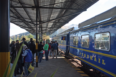
 John delivered us to the station and dispatched us with our tickets for the ride to and from Aguas Calientes,the station from which the ruins are accessed. We entered the departure hall and found a place to hang out until they opened the gates to load the coaches. The waiting area is tourist city with folks from all corners of the world, waiting to get on board the trail. They are lined up and anxious but seem to forget that each seat has a number that corresponds to the number on the ticket in hand. There is no scramble for seats as there are only as many passengers as there are seats and each car seems to have a porter who makes sure the program works. John delivered us to the station and dispatched us with our tickets for the ride to and from Aguas Calientes,the station from which the ruins are accessed. We entered the departure hall and found a place to hang out until they opened the gates to load the coaches. The waiting area is tourist city with folks from all corners of the world, waiting to get on board the trail. They are lined up and anxious but seem to forget that each seat has a number that corresponds to the number on the ticket in hand. There is no scramble for seats as there are only as many passengers as there are seats and each car seems to have a porter who makes sure the program works.
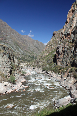 We boarded about 15 minutes before departure and made our way to our seats. As our tickets were in order, we had two windows and an aisle. Soon we were joined by seat mates, a family group from the Netherlands, who turned out to be totally normal. The train soon left and we made talk for the most of the ride to Aguas Calientes. The train initially travels We boarded about 15 minutes before departure and made our way to our seats. As our tickets were in order, we had two windows and an aisle. Soon we were joined by seat mates, a family group from the Netherlands, who turned out to be totally normal. The train soon left and we made talk for the most of the ride to Aguas Calientes. The train initially travels 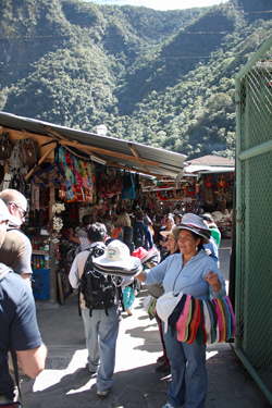 along the valley floor, descending but not at a steep rate until it enters a canyon and really begins the descent that will last for the remainder of the trip. At one point, the descent is too steep for ordinary track design and, as a result, the train makes a switchback in order to drop a sufficient distance to continue its run through what now becomes a full fledged canyon with towering walls on both sides. along the valley floor, descending but not at a steep rate until it enters a canyon and really begins the descent that will last for the remainder of the trip. At one point, the descent is too steep for ordinary track design and, as a result, the train makes a switchback in order to drop a sufficient distance to continue its run through what now becomes a full fledged canyon with towering walls on both sides.
The train continues through the canyon for the rest of the trip, stopping at the juncture of the Inca trail and the railway; however there is no time for any exit and wander about the station. For the whitewater rafter or hard boater, the river that occupies the bottom of the canyon offers continuing whitewater, capturing the atention of this former 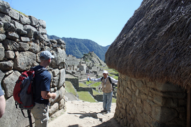 boater. We saw it at low water, I can only imagine the difficulty of the rapids when the river is flush with summer runoff. There are other sights along the way such as Nevado Veronica, a snow capped mountain of significance to the Inca, a hydro dam, and the locals just going about their daily business. boater. We saw it at low water, I can only imagine the difficulty of the rapids when the river is flush with summer runoff. There are other sights along the way such as Nevado Veronica, a snow capped mountain of significance to the Inca, a hydro dam, and the locals just going about their daily business.
After a bit over three hours, the train arrived at the Aguas Caliente station and we got off to secure our tickets to the ruins. John had made arrangements for a local guide to meet us at the station in order to obtain tickets. We were also told that this fellow could provide a guided tour of the ruins and we figured this was the way to go as none of us had invested time otherwise to develop sufficientbackground knowledge 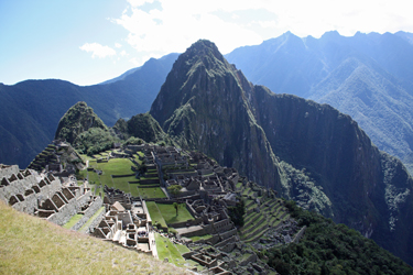 of the site faciliate any sort of meaningful walk about. Abelardo guide met us as we left the station gate and soon we were off through the warren of hawkers and souvenir sales areas that form a bazaar extending for perhaps one hundred yards beyond the rail station gate. Once you traverse the maze of vendors, you cross the river into Aguas Calientes proper where our guide parked us in the main square and departed with our passports in hand to get our entry tickets. of the site faciliate any sort of meaningful walk about. Abelardo guide met us as we left the station gate and soon we were off through the warren of hawkers and souvenir sales areas that form a bazaar extending for perhaps one hundred yards beyond the rail station gate. Once you traverse the maze of vendors, you cross the river into Aguas Calientes proper where our guide parked us in the main square and departed with our passports in hand to get our entry tickets.
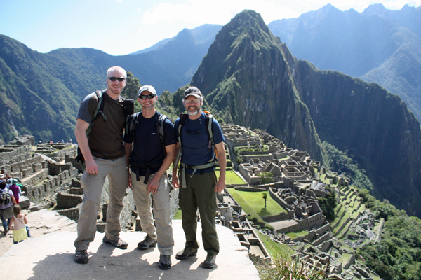
Abelardo was back in ten minutes, tickets in hand for the ruins and the bus, and we were off. The ruins themselves are atop an adjacent mountain and the distance between town and the ruins is covered in a shuttle bus that climbs 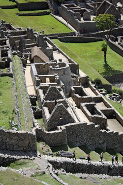 well over 1000 feet and covers a couple of miles in the process. One can walk but doing so would consume the morning and would seem to functionally force an overnight in the process if any time at the ruins was desired before heading back to catch the train. The bus operation is a seamless affair and soon enough we were riding up the switchback road to the ruins above. Once at the top, we presented our tickets and were on our way to the initial overlook, from which the ruins present themselves in classic National Geographic fashion. well over 1000 feet and covers a couple of miles in the process. One can walk but doing so would consume the morning and would seem to functionally force an overnight in the process if any time at the ruins was desired before heading back to catch the train. The bus operation is a seamless affair and soon enough we were riding up the switchback road to the ruins above. Once at the top, we presented our tickets and were on our way to the initial overlook, from which the ruins present themselves in classic National Geographic fashion.
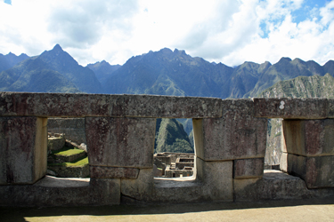
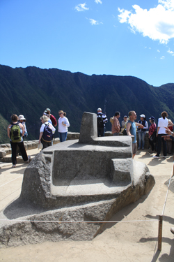 I'll say this about Machu Picchu . . . what you see on the cover of National Geographic and/or a travel poster is what you get. Ruins, green terraces, scenic background . . . all in a pristine trash free state. Sometimes you don't get all of those thrown into one package south of the border but this site is everything it is made out to be. Abelardo gave us an overview of the site in good english and then we wandered up a hill to gain an even better perspective. We ended up with a 3 hour I'll say this about Machu Picchu . . . what you see on the cover of National Geographic and/or a travel poster is what you get. Ruins, green terraces, scenic background . . . all in a pristine trash free state. Sometimes you don't get all of those thrown into one package south of the border but this site is everything it is made out to be. Abelardo gave us an overview of the site in good english and then we wandered up a hill to gain an even better perspective. We ended up with a 3 hour 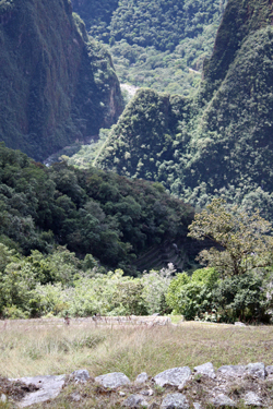 tour of the site, with an excellent explanation of the astronomical aspects, development aspects, and general archeology of the site from its "discovery" to present. What is also interesting is the number of terraces that flow down the hill into the unexcavated and well vegetated flanks of the site. Clearly, Machu Picchu is only partially excavated. tour of the site, with an excellent explanation of the astronomical aspects, development aspects, and general archeology of the site from its "discovery" to present. What is also interesting is the number of terraces that flow down the hill into the unexcavated and well vegetated flanks of the site. Clearly, Machu Picchu is only partially excavated.
Some of the highlights of the site for us included the incredible stone work where Inca stone cutters integrated the natural rock with their structures. The size of the stones moved is fascinating as is the degree of precision they maintained in their fitting of stones throughout the site. As 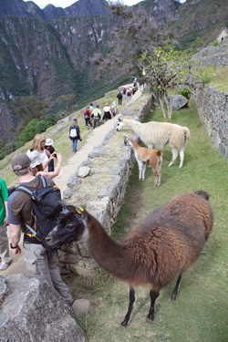 noted, our three hour tour gave us a good overview and we had all the time we needed to cover the site. Our schedule did not allow for an extended visit but I'll confess to having a causal interest in ruins and I knew that we would be spending the next two weeks trekking through mountains, with plenty of time available for relaxing with the surroundings. We concluded our visit and were off for the bus back down to town. noted, our three hour tour gave us a good overview and we had all the time we needed to cover the site. Our schedule did not allow for an extended visit but I'll confess to having a causal interest in ruins and I knew that we would be spending the next two weeks trekking through mountains, with plenty of time available for relaxing with the surroundings. We concluded our visit and were off for the bus back down to town.
We had an hour and a bit to wait before the train's departure so we lunched at one of the huge number of eateries in Aguas Calientes. We went light as we planned to find "that" Lomo joint that Carlos told us of when we got back to Cusco. Regardless, the we picked out a place to eat, to the delight of the waiter who also serves as a barker and tout, and had a light lunch, complete with the golden cola . . . of course. From there is was back to the train and what I'd call a long ride back to Cusco. The three hour ride to the site was fun and interesting, but the ride back, especially after dark, got a bit tiresome and I was quite content to be back at the Poroy station, with a ride waiting to town.
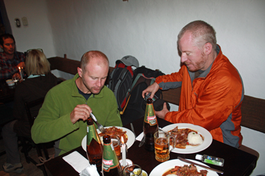
 Did I mention that John was dead on dependable? Well needless to say, he was spot on and soon delivered us to an alternative restaurant, one block from the hotel, that he said (and correctly so) served a really good Lomo Saltado. John even came in and mentioned to the waiter that we'd like a bit of heat in the mix and soon enough we had Lomo a bit more like that of the northern mountains. The dinner was great and the beers went down smoothly. However, as much as we would like to have called it a day, we still had to gather our gear for the start of the real reason for our trip, a trip to the trail head and the beginning of the climbing portion of the adventure. Did I mention that John was dead on dependable? Well needless to say, he was spot on and soon delivered us to an alternative restaurant, one block from the hotel, that he said (and correctly so) served a really good Lomo Saltado. John even came in and mentioned to the waiter that we'd like a bit of heat in the mix and soon enough we had Lomo a bit more like that of the northern mountains. The dinner was great and the beers went down smoothly. However, as much as we would like to have called it a day, we still had to gather our gear for the start of the real reason for our trip, a trip to the trail head and the beginning of the climbing portion of the adventure.
 It took us about an hour to sort gear into four duffels and otherwise get ready for our 7:00 departure for the trailhead in the town of Tinqui. We had already met with our cook as to eating preferences and knew at this point that Carlos pretty much had these types of arrangements dialed in, hence no worries at this point. We piled the duffels in the corner and hit the hay as we knew the alarm would go off all to early the next morning. It took us about an hour to sort gear into four duffels and otherwise get ready for our 7:00 departure for the trailhead in the town of Tinqui. We had already met with our cook as to eating preferences and knew at this point that Carlos pretty much had these types of arrangements dialed in, hence no worries at this point. We piled the duffels in the corner and hit the hay as we knew the alarm would go off all to early the next morning.
|
