Mt. Champion & Pt. 13,736
November 4, 2012 - South Ridge from Hwy. 82 Hairpin Turn
A climb of Mt. Champion and Pt. 13,736 seemed like the perfect way to spend a bluebird day, one of a series that now spanned the later half of October and were expanding into November. We had spent the previous night at the Leadville Super 8 after a great Lomo Saltado meal on the way through Denver and we were ready to climb. But no need to hurry at this time of year, we arrived at the trailhead at 8 a.m. after a stop in town for coffee, hot chocolate and some pastries. No thunderstorms . . . no hurry.
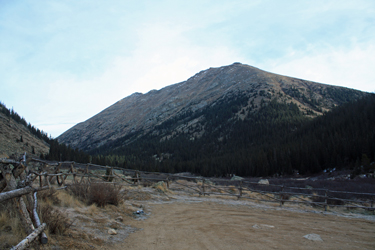 Our first decision was whether to hike up the valley to ascend a far ridge to the summit of Pt. 13,736 or, alternatively, get the climbing part of the day over by taking on Mt. Champion's south ridge. We chose to respond to the chill morning air by warming up with the climb to the summit of Champion. From there we would traverse to the Pt. and then descend to the valley for the walk out. G, Cal and I hefted our packs and we were on our way through the gate, headed up the two track to toward the base of Mt. Champion. We went perhaps a quarter mile before turning east to cross the creek and loom for a route up the southern end of Champion. Our first decision was whether to hike up the valley to ascend a far ridge to the summit of Pt. 13,736 or, alternatively, get the climbing part of the day over by taking on Mt. Champion's south ridge. We chose to respond to the chill morning air by warming up with the climb to the summit of Champion. From there we would traverse to the Pt. and then descend to the valley for the walk out. G, Cal and I hefted our packs and we were on our way through the gate, headed up the two track to toward the base of Mt. Champion. We went perhaps a quarter mile before turning east to cross the creek and loom for a route up the southern end of Champion.
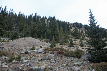 The creek offered a dry rock crossing after which we headed for a muck pile on the premise that there was a mine up high on the flank and a muck pile down low. Even though the Champion Mine was serviced by an aerial tramway, I hoped that some reason caused someone to cut a trail down to his side of the mountain to gain the Independence Pass track of years gone by. I also kind of spotted a squiggle on the map indicating a number of old road beds. Well . . . we did not intercept the road of my hope and instead cut a strong trail a couple hundred yards directly up through the timber. The trail lead upward and around the end of the mountain to an opening at the base of an inviting gully. The creek offered a dry rock crossing after which we headed for a muck pile on the premise that there was a mine up high on the flank and a muck pile down low. Even though the Champion Mine was serviced by an aerial tramway, I hoped that some reason caused someone to cut a trail down to his side of the mountain to gain the Independence Pass track of years gone by. I also kind of spotted a squiggle on the map indicating a number of old road beds. Well . . . we did not intercept the road of my hope and instead cut a strong trail a couple hundred yards directly up through the timber. The trail lead upward and around the end of the mountain to an opening at the base of an inviting gully.
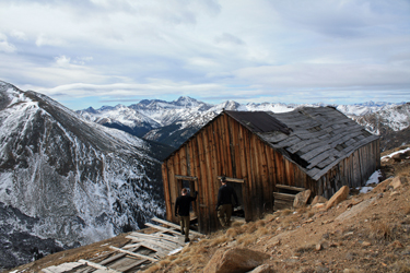 We worked our way upward, skipping a number of trail segments to just take a direct "get it over with" line upward. The theory worked just fine as we gained elevation and within an hour or so broke the skyline that we knew was not the summit but would certainly be getting close. The skyline break was of course a change of slope and as we took a breather, we could see the remains of the Champion Mine off to the east. Being a mining head and having curious Cal on board, meant that we had to check out the ruins, simply no other option. The old winding gear lay in a nearby depression and the gang house offered a moment to consider miners past and the harsh winters that took their toll on both men and machine. We worked our way upward, skipping a number of trail segments to just take a direct "get it over with" line upward. The theory worked just fine as we gained elevation and within an hour or so broke the skyline that we knew was not the summit but would certainly be getting close. The skyline break was of course a change of slope and as we took a breather, we could see the remains of the Champion Mine off to the east. Being a mining head and having curious Cal on board, meant that we had to check out the ruins, simply no other option. The old winding gear lay in a nearby depression and the gang house offered a moment to consider miners past and the harsh winters that took their toll on both men and machine.
 From the Champion Mine, we cut north and passed a few more collapsed adits before simply walking the more sedate slope to the summit proper to join the wind that had allowed us to this point without an interference. That would not be the case from the Champion summit on. The down jackets came out and after having a bite to eat and leaving a worm for Pacha, we were up and on our way across the ridge and saddle to Pt. 13,736. The wind was biting, and cold hands were had by all. From the Champion Mine, we cut north and passed a few more collapsed adits before simply walking the more sedate slope to the summit proper to join the wind that had allowed us to this point without an interference. That would not be the case from the Champion summit on. The down jackets came out and after having a bite to eat and leaving a worm for Pacha, we were up and on our way across the ridge and saddle to Pt. 13,736. The wind was biting, and cold hands were had by all.
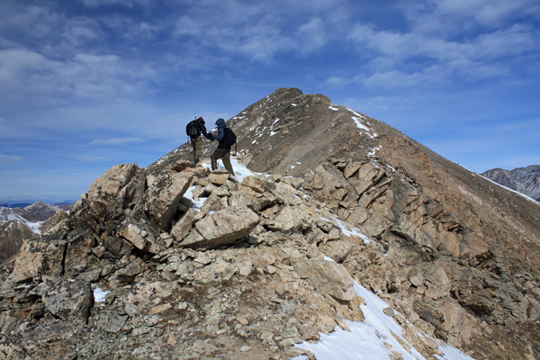
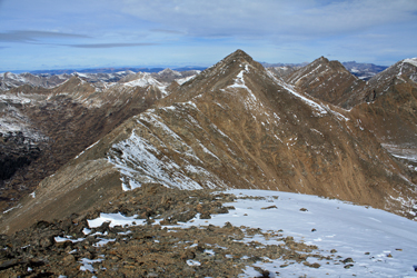 The mittens and heavy gloves came out and the hoods and wind stopper hats were broken out for the traverse. The route was a range of class 2 terrain, broken here and there by a hand and foot scramble up a rocky hump. Once we passed the saddle, the uphill movement started to warm the hands again as the terrain treated us to climbs along the steeper eastern side of the ridge. For me, the terrain was a test ground for the healing ankle, broken 12 weeks before in the San Juans. The range of motion is not what it wa so I took a bit of extra time over the more rough terrain, paying a bit more attention to the foot placement than I once did, where hopping talus was an effortless affair. The mittens and heavy gloves came out and the hoods and wind stopper hats were broken out for the traverse. The route was a range of class 2 terrain, broken here and there by a hand and foot scramble up a rocky hump. Once we passed the saddle, the uphill movement started to warm the hands again as the terrain treated us to climbs along the steeper eastern side of the ridge. For me, the terrain was a test ground for the healing ankle, broken 12 weeks before in the San Juans. The range of motion is not what it wa so I took a bit of extra time over the more rough terrain, paying a bit more attention to the foot placement than I once did, where hopping talus was an effortless affair.
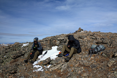
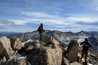 We topped the rocky summit of Pt. 13,736 at about 11:30 a.m. and found shelter from the wind long enough for some gummy bears, Gu and hydration. We discussed the route down and in lieu of taking the northerly ridge of Pt. 13,736, we opted to return to the summit between the Point and Champion, where we spied what looked like a route downward. The traverse back to the saddle was easy, the drop from there was the test to date of the ankle and he psyche. We knew that the visible part of the route would be a mix of scree and smaller talus, mostly likely loose. We topped the rocky summit of Pt. 13,736 at about 11:30 a.m. and found shelter from the wind long enough for some gummy bears, Gu and hydration. We discussed the route down and in lieu of taking the northerly ridge of Pt. 13,736, we opted to return to the summit between the Point and Champion, where we spied what looked like a route downward. The traverse back to the saddle was easy, the drop from there was the test to date of the ankle and he psyche. We knew that the visible part of the route would be a mix of scree and smaller talus, mostly likely loose.
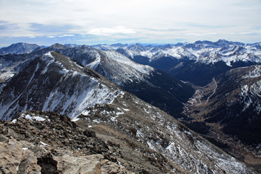 We were not wrong and in response we intentionally cut out of the trough zone and onto the bounding ridge, hoping for consolidated ground. The route to the ridge in and of itself was an exercise in steep loose ground as we trended south into a steep zone, requiring a cut back to the north to skirt the class 5 ground. We attained the ridge and got the relief we wanted until the bottom third of the descent. The selection of routes narrowed as the ground cliffed and offered a small selection of slots and juniper covered noses for descent routes. We were not wrong and in response we intentionally cut out of the trough zone and onto the bounding ridge, hoping for consolidated ground. The route to the ridge in and of itself was an exercise in steep loose ground as we trended south into a steep zone, requiring a cut back to the north to skirt the class 5 ground. We attained the ridge and got the relief we wanted until the bottom third of the descent. The selection of routes narrowed as the ground cliffed and offered a small selection of slots and juniper covered noses for descent routes.
 Cal took a nose, G and I put our bet on a slot and we both won. My route was loose as heck and I used those hiking poles to the absolute max. We broke the steep zone and dropped to the boggy valley floor via a talus fan and cut across the flats to the far side where we knew there was a strong trail leading downstream to the trailhead. the trail turned out to be all the way up at the edge of the far tree line but it made for dry and quick travel and within 15 minutes we were back at the truck, having achieved two Bicentennial summits in 6 hours. Cal took a nose, G and I put our bet on a slot and we both won. My route was loose as heck and I used those hiking poles to the absolute max. We broke the steep zone and dropped to the boggy valley floor via a talus fan and cut across the flats to the far side where we knew there was a strong trail leading downstream to the trailhead. the trail turned out to be all the way up at the edge of the far tree line but it made for dry and quick travel and within 15 minutes we were back at the truck, having achieved two Bicentennial summits in 6 hours.
|
