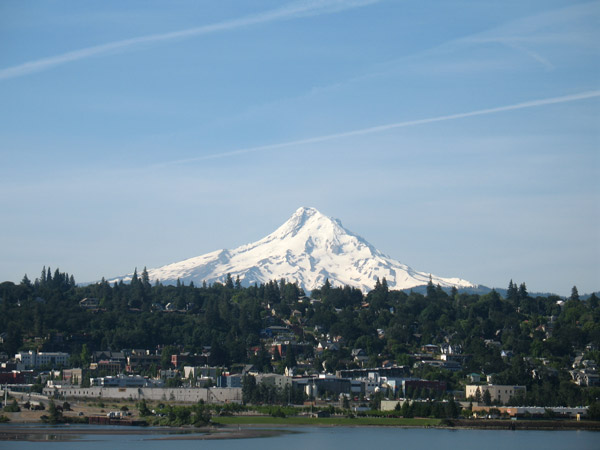
Mount Hood
Hogsback Route with Old Crater Variation - June 18, 2008
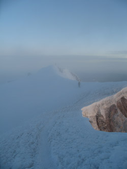
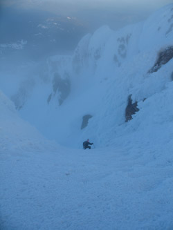
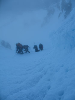
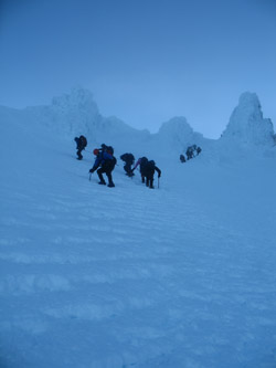
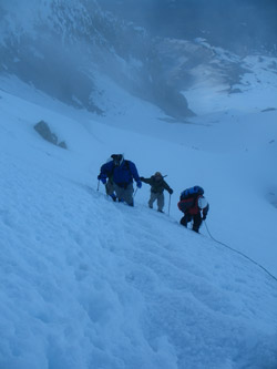
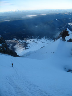
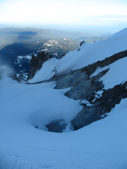
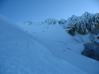
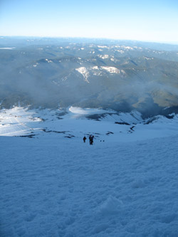
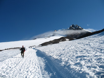
(photos show descent from summit, entire ascent was before dawn)
We moved onto Mt. Hood following our successful climb of Mt. Rainier just a few days earlier. We came off Rainier and 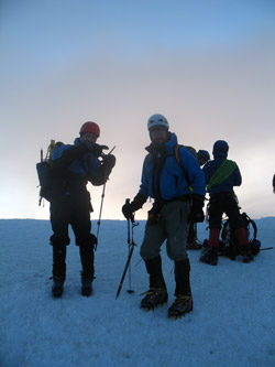 headed toward Portland to find some good food and a place to stay before making a stop the next morning at the Mountaineer Shop (on Broadway in downtown Portland) to see if we could find a guide to the routes on Hood or just some old fashioned word of mouth as to the conditions on the mountain. We were lucky enough to find a fellow who was familiar with a number of the routes and he gave us a good bit of insight as to what might be in shape as well as the recent snow conditions. headed toward Portland to find some good food and a place to stay before making a stop the next morning at the Mountaineer Shop (on Broadway in downtown Portland) to see if we could find a guide to the routes on Hood or just some old fashioned word of mouth as to the conditions on the mountain. We were lucky enough to find a fellow who was familiar with a number of the routes and he gave us a good bit of insight as to what might be in shape as well as the recent snow conditions.
 We left Portland and headed for the parking lot of the Timberline Lodge. This would be our starting point for the climb so we wanted to see as much of the route as possible before we arrived at 0 dark 30 the next morning. The route was clear as there appeared to be a herd path from the base to the break in the crater rim just prior to the summit, slightly out of view. We found the climber check in/registration desk just inside the door of the lower ski lodge and picked up a self registration packet and a supply of blue bags for the climb. We left Portland and headed for the parking lot of the Timberline Lodge. This would be our starting point for the climb so we wanted to see as much of the route as possible before we arrived at 0 dark 30 the next morning. The route was clear as there appeared to be a herd path from the base to the break in the crater rim just prior to the summit, slightly out of view. We found the climber check in/registration desk just inside the door of the lower ski lodge and picked up a self registration packet and a supply of blue bags for the climb.
 Our planned start at midnight did not leave much time for sleep so rather than get a room, we pitched camp at a National Forest Service campground on the south side of the road about half way between Government Camp and Rhododendron. We sorted gear, pitched the tents and ate enough dinner to perhaps make for uncomfortably full stomachs at the start of the climb, just a few hours distant. The alarm was set for 11 p.m. and as one can imagine, it went off on time . . . but still too darn early. The camp came down in a few minutes and we were on our way to the overnight parking area of the lodge. Our planned start at midnight did not leave much time for sleep so rather than get a room, we pitched camp at a National Forest Service campground on the south side of the road about half way between Government Camp and Rhododendron. We sorted gear, pitched the tents and ate enough dinner to perhaps make for uncomfortably full stomachs at the start of the climb, just a few hours distant. The alarm was set for 11 p.m. and as one can imagine, it went off on time . . . but still too darn early. The camp came down in a few minutes and we were on our way to the overnight parking area of the lodge.
 We were climbing in mid June but we still not expect to see 20 cars parked ahead of us and quite a few groups gathering their gear for a summit climb. Obviously we would have company this morning . . . We set off at 12:05 and it was warm, as in the low 40's at the parking lot. Of course, we had 5000 vertical feet to put under our feet and it would cool down as we climbed through the night. The route for those starting from the base on foot, as compared those avail themselves of the snow cat ride up the first 2500 to 3000 feet, runs along the eastern edge of the flank of the mountain side which is groomed for the skiers year round. The snow was warm but in good shape and we post holed very little before traversing over to the the snow cat groomed path right at the edge of the groomed slope. We were climbing in mid June but we still not expect to see 20 cars parked ahead of us and quite a few groups gathering their gear for a summit climb. Obviously we would have company this morning . . . We set off at 12:05 and it was warm, as in the low 40's at the parking lot. Of course, we had 5000 vertical feet to put under our feet and it would cool down as we climbed through the night. The route for those starting from the base on foot, as compared those avail themselves of the snow cat ride up the first 2500 to 3000 feet, runs along the eastern edge of the flank of the mountain side which is groomed for the skiers year round. The snow was warm but in good shape and we post holed very little before traversing over to the the snow cat groomed path right at the edge of the groomed slope.
 The key to the climb at this point was to find the right track through the snow torn up by the snow cat tracks. The snow cat tracks do not compact the snow but instead make a shredded mess of all but a centerline icy strip. That strip was our salvation as it minimized having to walk along in 4 to 5 inches of nicely crushed ice. We climbed through the darkness, steadily gaining vertical and being passed about every half hour to forty-five minutes by a snow cat filled with guided climbing teams. Not a bad racket, get the first 2500 to 3000 feet out of the way without any effort whatsoever. The key to the climb at this point was to find the right track through the snow torn up by the snow cat tracks. The snow cat tracks do not compact the snow but instead make a shredded mess of all but a centerline icy strip. That strip was our salvation as it minimized having to walk along in 4 to 5 inches of nicely crushed ice. We climbed through the darkness, steadily gaining vertical and being passed about every half hour to forty-five minutes by a snow cat filled with guided climbing teams. Not a bad racket, get the first 2500 to 3000 feet out of the way without any effort whatsoever.
 We arrived at the snow cat drop point after about 2 1/2 hours of climbing afterwhich the route left the graded course and stretched onto decent snow. No crampons yet but good cold snow that was giving a minimal track . . . but I'll admit that we cheated a bit, trekking up a good course of steps set by another climber. We reached a rock band and sought a spot out of the slight but quite humid wind. It was not that cold but I think the moisture in the air cut through my layering system that in the dry air of Colorado has never before failed me. We shot a Gu, drank some water, applied crampons and each swapped an ice axe for one of our hiking poles. We arrived at the snow cat drop point after about 2 1/2 hours of climbing afterwhich the route left the graded course and stretched onto decent snow. No crampons yet but good cold snow that was giving a minimal track . . . but I'll admit that we cheated a bit, trekking up a good course of steps set by another climber. We reached a rock band and sought a spot out of the slight but quite humid wind. It was not that cold but I think the moisture in the air cut through my layering system that in the dry air of Colorado has never before failed me. We shot a Gu, drank some water, applied crampons and each swapped an ice axe for one of our hiking poles. 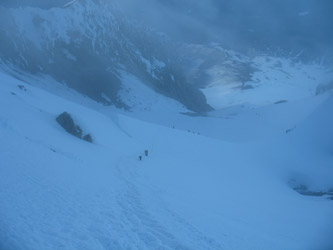 The route next led up a constant slope, perhaps 20 degrees more or less, into the remnant of the crater, the south side of which appears to have blown out and or been eroded away many moons ago. We topped this walking pitch and the ground steepened as we made the next traverse that would lead us to the "Hogsback" snow ridge that provides access to the remnant north wall of the crater rim. We now encountered the smell of sulphur from the fumeroles that flank the approach to the Hogsback, each devoid of snow and issuing a plume of yellow smoke/vapor. The route next led up a constant slope, perhaps 20 degrees more or less, into the remnant of the crater, the south side of which appears to have blown out and or been eroded away many moons ago. We topped this walking pitch and the ground steepened as we made the next traverse that would lead us to the "Hogsback" snow ridge that provides access to the remnant north wall of the crater rim. We now encountered the smell of sulphur from the fumeroles that flank the approach to the Hogsback, each devoid of snow and issuing a plume of yellow smoke/vapor.
 The traversing trail, perhaps no longer than a few hundred yards, deposited us at the start of the Hogsback proper, where we took a moment to survey the route and elected to continue to the summit un-roped. Ahead of us lay a steeper, perhaps 30 to 35 degree ridge, perhaps just a bit more than one hundred yards at most into which a herd path had been cut by many previous groups. We saw two guided ropes ahead of us and slowed our ascent in the hope that if we dithered our way up the slope, they would stay ahead of us enough that we would not have to stop and wait for them before they crested the crater rim. The traditional route up through the rim went through a pitch called the Pearly Gates. Now, the Pearly Gates route had no visible traffic as the guided groups were traversing 70 degrees to the left at the bergshrund instead of crossing the gap and going on up the remainder of the Hogsback. The "in route" is referred to as the Old Crater Variation and we elected to stick with that route as well. The traversing trail, perhaps no longer than a few hundred yards, deposited us at the start of the Hogsback proper, where we took a moment to survey the route and elected to continue to the summit un-roped. Ahead of us lay a steeper, perhaps 30 to 35 degree ridge, perhaps just a bit more than one hundred yards at most into which a herd path had been cut by many previous groups. We saw two guided ropes ahead of us and slowed our ascent in the hope that if we dithered our way up the slope, they would stay ahead of us enough that we would not have to stop and wait for them before they crested the crater rim. The traditional route up through the rim went through a pitch called the Pearly Gates. Now, the Pearly Gates route had no visible traffic as the guided groups were traversing 70 degrees to the left at the bergshrund instead of crossing the gap and going on up the remainder of the Hogsback. The "in route" is referred to as the Old Crater Variation and we elected to stick with that route as well.
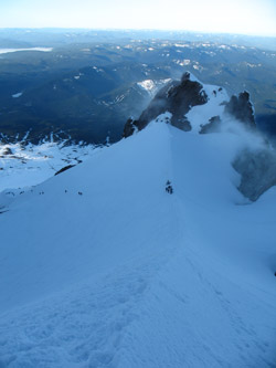 The guided groups plodded along, five to a rope, steadily climbing along an ascending path cut into the now steeper 45 degree side slope of the crater. We maintained a creep, not wanting to be in their slide path in the event another Mt. Hood debacle was in the cards. After about 200 yards, we too turned toward the rim and made our way up the steepest section of the route, a hard snow slope, likely running about 50 degrees. The groups had cut a regular set of steps into the slope but none the less, one did not want to take a slide to the fumeroles, perhaps 400 vertical feet below. The guided groups plodded along, five to a rope, steadily climbing along an ascending path cut into the now steeper 45 degree side slope of the crater. We maintained a creep, not wanting to be in their slide path in the event another Mt. Hood debacle was in the cards. After about 200 yards, we too turned toward the rim and made our way up the steepest section of the route, a hard snow slope, likely running about 50 degrees. The groups had cut a regular set of steps into the slope but none the less, one did not want to take a slide to the fumeroles, perhaps 400 vertical feet below.
 G was out ahead, climbing through a guided group as Ed and I proceeded more slowly behind the second rope. Ed worked his way to the break in the crater rim but I suffered one of those moments on the mountain that is better put off but doing so is not always an option. Simply put the turtle's head was peeking out and it was not going to go back in. There was no one ahead and the two following ropes had yet to creep around to the steeper pitch and into sight . . . what the hell. I set those crampons and and broke out the blue bag, more or less filled it, and carefully applied the twist tie . What do you do with a blue bag on a 50 degree slope? Well, my answer was simple, I'd been cold all morning so a blue bag tucked nicely against the chest brought a touch of warmth and put off the inevitable entropy for just a few minutes more. Sorry folks, but that is the reality of mountaineering and sometimes you just make due with the cards you are dealt. G was out ahead, climbing through a guided group as Ed and I proceeded more slowly behind the second rope. Ed worked his way to the break in the crater rim but I suffered one of those moments on the mountain that is better put off but doing so is not always an option. Simply put the turtle's head was peeking out and it was not going to go back in. There was no one ahead and the two following ropes had yet to creep around to the steeper pitch and into sight . . . what the hell. I set those crampons and and broke out the blue bag, more or less filled it, and carefully applied the twist tie . What do you do with a blue bag on a 50 degree slope? Well, my answer was simple, I'd been cold all morning so a blue bag tucked nicely against the chest brought a touch of warmth and put off the inevitable entropy for just a few minutes more. Sorry folks, but that is the reality of mountaineering and sometimes you just make due with the cards you are dealt.
 My business completed, I climbed no more than 25 feet to the top of the crater rim and walked to the true summit about 50 yards distant along a well corniced slope. The other two ropes were on the top and we slipped in next to the pack, snapped a few photos and made a beeline back to the top of the ice slope leading down. As we were not climbing as a roped team and we had no clients in tow, our plan was to courteously play through the pack and get off the peak before these ropes got into the swing of the belay down the slope. Credit due, the guides for the rope setting up a belay at the top of the slope took one look at us, offered a play through, and off we went. The other teams were now ascending the crux of the climb, so we set course off to their side and let them creep upward. My business completed, I climbed no more than 25 feet to the top of the crater rim and walked to the true summit about 50 yards distant along a well corniced slope. The other two ropes were on the top and we slipped in next to the pack, snapped a few photos and made a beeline back to the top of the ice slope leading down. As we were not climbing as a roped team and we had no clients in tow, our plan was to courteously play through the pack and get off the peak before these ropes got into the swing of the belay down the slope. Credit due, the guides for the rope setting up a belay at the top of the slope took one look at us, offered a play through, and off we went. The other teams were now ascending the crux of the climb, so we set course off to their side and let them creep upward.
 As we passed these groups, I remembered my earlier days of snow climbing years before. The guides were putting in protection and moving the ropes upward and each client was crouched in a low self belay position as the guide offered instruction. We simply walked by on our way down the slope, but such is the benefit of experience as compared to the first time out. I think we played through no less than five or six rope teams as we took a slightly up slope course on our way back down the long traverse to the bergshrund break and then down the Hogsback proper to the saddle on the ridge between the fumeroles. We dropped the packs for a minute or two, goo and drinks in hand, letting yet more rope teams pass before we hiked on down to the edge of the crater basin and dropped onto the more gentle slopes below. As we passed these groups, I remembered my earlier days of snow climbing years before. The guides were putting in protection and moving the ropes upward and each client was crouched in a low self belay position as the guide offered instruction. We simply walked by on our way down the slope, but such is the benefit of experience as compared to the first time out. I think we played through no less than five or six rope teams as we took a slightly up slope course on our way back down the long traverse to the bergshrund break and then down the Hogsback proper to the saddle on the ridge between the fumeroles. We dropped the packs for a minute or two, goo and drinks in hand, letting yet more rope teams pass before we hiked on down to the edge of the crater basin and dropped onto the more gentle slopes below.
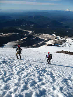 Once on the gentler slopes, we needed only to complete a 4000 vertical downhill slog to make it back to the parking lot. We dropped another 500 feet or so, packed away the ice axes in favor of two hiking poles and spent the next two hours, first on good snow and then on steadily crappier snow as the sun warmed the slopes. We hit the parking lot at 9:30 a.m., having left at just a bit after midnight, made the summit at 5:30 a.m., and ascended and then descended 5000 vertical feet. Once on the gentler slopes, we needed only to complete a 4000 vertical downhill slog to make it back to the parking lot. We dropped another 500 feet or so, packed away the ice axes in favor of two hiking poles and spent the next two hours, first on good snow and then on steadily crappier snow as the sun warmed the slopes. We hit the parking lot at 9:30 a.m., having left at just a bit after midnight, made the summit at 5:30 a.m., and ascended and then descended 5000 vertical feet.
 In hindsight, the greatest challenge of Hood came in the mindless slog up to the snow cat drop-off point and then the frustration of working one's way up the rest of the peak in and or around rope teams on the steeper sections. We could have avoided any frustration by selecting another route, but our beta indicated that the snow conditions had been a bit tenuous on other routes over the past days due to recent storms. We also did not realize that few folks had been climbing Hood recently and the weather window we were thankful to have was the same window all the local climbers and guided groups had been waiting for. As the photos attest, Hood was a crowded climb, a condition were were simply not accustomed to as most our climbing is not in the summer hiking/climbing season and is usually on more challenging routes. Regardless, we'd scored the high point for Oregon, a second summit for trip, and another day in what was turning out to be a wonderful weather window. In hindsight, the greatest challenge of Hood came in the mindless slog up to the snow cat drop-off point and then the frustration of working one's way up the rest of the peak in and or around rope teams on the steeper sections. We could have avoided any frustration by selecting another route, but our beta indicated that the snow conditions had been a bit tenuous on other routes over the past days due to recent storms. We also did not realize that few folks had been climbing Hood recently and the weather window we were thankful to have was the same window all the local climbers and guided groups had been waiting for. As the photos attest, Hood was a crowded climb, a condition were were simply not accustomed to as most our climbing is not in the summer hiking/climbing season and is usually on more challenging routes. Regardless, we'd scored the high point for Oregon, a second summit for trip, and another day in what was turning out to be a wonderful weather window.
|
