-
Mt. Bierstadt Group Summit - Front Range, Colorado
-
A rest before the summit push on Dallas Peak - San Juan Range, Colorado
-
Broken Ankle + 6 Miles = Tired
-
The classic San Juan approach - San Juan Range, Colorado
-
Overlooking Noname Basin from Twin Thumbs Pass - San Juan Range, Colorado
-
Upper Noname Basin - San Juan Range, Colorado
-
Nearing Noname Cabin - San Juan Range, Colorado
-
Twin Thumbs Twins - San Juan Range, Colorado
-
Nearing the summit of Pt. 13,736 - Sawatch Range, Colorado
-
Blustery day on Iowa Peak - Sawatch Range, Colorado
-
Morning snow at 15k, Cerro Ramada - Cordillera Ramada
-
Artesonraju from the summit of Nevado Pisco - Cordillera Blanca, Peru
-
February crowds on Gray's Peak - Front Range, Colorado
-
Kicking steps on Cerro Lliani - Cordillera Vilcanota, Peru
-
Final traverse to the summit of Wheeler Mountain - Ten Mile Range, Colorado
-
The long walk to Pachanta - Cordillera Vilcanota, Peru
- banner31
Afternoon at 17k on Cerro Ramada - Cordillera Ramada, Argentina
- banner22
The final ridge on Iowa Peak - Sawatch Range, Colorado
-
Summer summit on Longs Peak - Front Range, Colorado
-
A rest day at the Pachanta Hot Springs - Cordillera Vilcanota, Peru
-
Mind over matter on Mt. Parnassas - Front Range, Colorado
-
Rest stop on Cerro Lliani - Cordillera Vilcanota, Peru
- banner30
Post nap surprise on Cerro Ramada - Cordiller Ramada, Argentina
-
Summit on Cerro Lliani - Cordillera Vilcanota, Peru
- banner23
Ridge walking on Grizzly Peak - Sawatch Range, Colorado
-
Enroute the summit via the West Ridge on Pacific Peak - Ten Mile Range, Colorado
-
Mule train bound for Chilca - Cordillera Vilcanota, Peru
-
Taking in the view from Fletcher Peak - Ten Mile Range, Colorado
-
Hiking on Silverheels - Mosquito Range, Colorado
-
Traversing! Gladstone Peak - San Juan Range, Colorado
- banner24
The best of times at Willow Lake - Sangre de Christo Range, Colorado
- banner29
High Altitude Cerebral Edema? - Cordillera Ramada, Argentina
-
Bound for Chilca - Vilcanota Range, Peru
-
Going alpine light, Holy Cross Ridge - Sawatch Range, Colorado
-
Cumbre! Campa I - Cordillera Vilcanota, Peru
-
Roadside lunch with the best of company - Cordillera Vilcanota, Peru
- banner25
Long ridge walk to the summit of California Peak - Sangre de Christo Range, Colorado
- banner28
Crossing el Rio Colorado . . . in the afternoon - Cordillera Ramada, Argentina
- banner37
Dealing with Fall snows high on Casco Peak - Sawatch Range, Colorado
-
Moonrise over Mercedario - Cordillera Ramada, Argentina
-
Still climbing at 20,900 on Cerro Ramada - Cordiller Ramada, Argentina
-
Talus on Halo Ridge, Mt. of the Holy Cross - Sawatch Range, Colorado
- banner26
Deteriorating conditions on Mt. Arkansas - Ten Mile Range, Colorado
- banner27
After the climb - Cordillera Ramada, Argentina
- banner38
Taking in the view from the summit of Crystal Peak - Tenmile Range, Colorado
-
Topping out on Mt. Arkansas' North Couloir - Mosquito Range, Colorado
-
Glissade on Mt. Arkansas - Mosquito Range, Colorado
-
Hard snow morning on Teakettle Mountain - San Juan Range, Colorado
-
Spring snow announces the start of the climb on Dallas Peak - San Juan Range, Colorado
-
Crossing the Eolus Catwalk - San Juan Range, Colorado

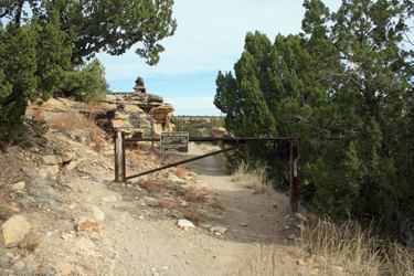 We'd driven the four hours from Cheyenne to La Junta the day before and done a short hike around Vogel Canyon, an nearby locale known for petroglyphs. After a KOA overnight and good Mexican food, we got an early morning start for the Withers Canyon trailhead, the entry point for Picketwire. The weather was perfect, 70 degrees, partly overcast and little if any wind. We parked at the trailhead, packed lunch and water and were soon on our way down the trail and through the pipe gate guarding the trail that descends into a tributary branch of the canyon.
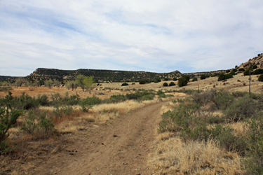 The trail descends about 250 vertical feet right after the gate and then gently descends for about a mile to the juncture with the main canyon is reached. The trail is actually a well worn 4WD track that provides firm but but sometimes sandy course . . . easy walking. The trail turns south to southwest and soon passes the remains of a building or two, remants of the prior use of the area by ranchers and herders. This is Santa Fe trail country and there is no doubt that many folks have passed through over the course of the past centuries. We continued
 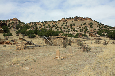 along, skirting the slopes above the Purgatoire River and sometimes winding along the broad canyon bottom . . . an up and down over a spur here and there. After about 2 miles we reached the site of the Dolores Mission. The ruins of the Mission include the remains of a structure and the associated graveyard.
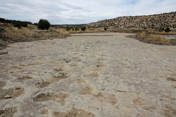
 Signage details the type of dinosaurs that made the two distinctive sets of tracks and the environment at the time the tracks were made. We took in the expanse of tracks along the river. There are literally hundreds of tracks exposed and likely untold others remain buried where the soils still overlie what was once mud and is now stone.
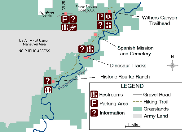