2006 Apolobamba Expedition
Trek from Sunchuli Camp to Jatunpampa Camp
 Today would be the first of two days that would eventually lead us to Charazani. We knew we had a long walk ahead of us and that we would cross a number of passes before we reached the pick-up point, two days hence. Alcides noted that the first day would be about 8 hours and that he wanted to get an 8 a.m. start on the hike. The Brits that shared our camp were going out as well and planned to start a bit earlier, but we figured to pass them fairly early as we were pretty fit at this point in the trip. Today would be the first of two days that would eventually lead us to Charazani. We knew we had a long walk ahead of us and that we would cross a number of passes before we reached the pick-up point, two days hence. Alcides noted that the first day would be about 8 hours and that he wanted to get an 8 a.m. start on the hike. The Brits that shared our camp were going out as well and planned to start a bit earlier, but we figured to pass them fairly early as we were pretty fit at this point in the trip.
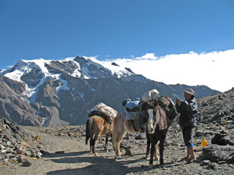
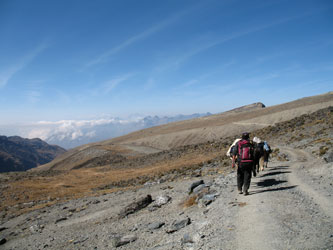
 Mario prepared a light breakfast while we broke the personal tents down and got the gear lined up for the mules. Breakfast over, Alcides arranged the now much lighter loads for the three members of the hauling crew. Each was loaded up, voicing their necessary complaints as they assumed their duties, and started down the trail. The route climbs out along the side of the valley, traversing the hillside above the Sunchuli mine and then slowly turns to the west to attain the 4900m pass that separates the Sunchuli valley from the valley containing the ruined mining hamlet of Viscachani. The trail intercepts the mining road at the top of the pass, where we stopped to adjust our loads and toss another rock onto the cairn formed by the similar efforts of travelers over the past. Mario prepared a light breakfast while we broke the personal tents down and got the gear lined up for the mules. Breakfast over, Alcides arranged the now much lighter loads for the three members of the hauling crew. Each was loaded up, voicing their necessary complaints as they assumed their duties, and started down the trail. The route climbs out along the side of the valley, traversing the hillside above the Sunchuli mine and then slowly turns to the west to attain the 4900m pass that separates the Sunchuli valley from the valley containing the ruined mining hamlet of Viscachani. The trail intercepts the mining road at the top of the pass, where we stopped to adjust our loads and toss another rock onto the cairn formed by the similar efforts of travelers over the past.
 We left the Sunchuli valley behind and hiked along the mining road as it switched back and forth to drop into a broad valley whose base held the Viscachani ruins. Little remains of the mining effort beside a few holes in the nearby outcrops of rock and the deteriorated walls of camp buildings. I do not know the history of this place but the story seems to be the same as I have seen over the breadth of Colorado. Miners came, they may have gotten something for their efforts and they moved on, leaving the harsh elements of the mountain climate to slowly erase their presence over the following years. We left the Sunchuli valley behind and hiked along the mining road as it switched back and forth to drop into a broad valley whose base held the Viscachani ruins. Little remains of the mining effort beside a few holes in the nearby outcrops of rock and the deteriorated walls of camp buildings. I do not know the history of this place but the story seems to be the same as I have seen over the breadth of Colorado. Miners came, they may have gotten something for their efforts and they moved on, leaving the harsh elements of the mountain climate to slowly erase their presence over the following years.
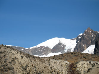
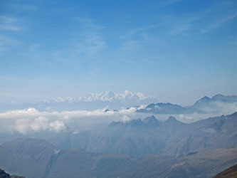
 The route from Viscachani departs the mining road and takes a well trodden trail traversing the hillside, passing small shallow lakes and contouring along the high ground as it gains elevation. Alcides, Mario, and the pack train had moved ahead over the morning and they soon disappeared around the crest of the hill as G and I took a more leisurely pace. To the north was Akamani, Cavayani and spine of the southern half of the Apolobamba range. We also saw Andean condors riding the thermals over the flank of Akamani as we trekked steadily along. We arrived at the crest of the hill and saw that the trail now turned to the north and descended to a divide at the edge of a deep canyon. There stood the mules and crew, awaiting our pokey arrival. The route from Viscachani departs the mining road and takes a well trodden trail traversing the hillside, passing small shallow lakes and contouring along the high ground as it gains elevation. Alcides, Mario, and the pack train had moved ahead over the morning and they soon disappeared around the crest of the hill as G and I took a more leisurely pace. To the north was Akamani, Cavayani and spine of the southern half of the Apolobamba range. We also saw Andean condors riding the thermals over the flank of Akamani as we trekked steadily along. We arrived at the crest of the hill and saw that the trail now turned to the north and descended to a divide at the edge of a deep canyon. There stood the mules and crew, awaiting our pokey arrival.
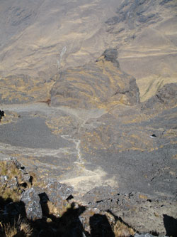
 We gathered at the edge of the canyon and took time for some lunch, we had been going for a half day and the rest felt good. We stopped for perhaps 15 minutes before Alcides told me that the next leg of our trip was to descend to the base of the adjacent canyon, about 2500 feet below. He noted that there were two routes to the bottom, but that only one was suitable for the pack train. He was going to get started and advised us to take the left turn at the juncture visible about 400 feet below our lunch spot. With G and I properly advised, he and Mario were off for the bottom of the canyon, where would would join up again later. We gathered at the edge of the canyon and took time for some lunch, we had been going for a half day and the rest felt good. We stopped for perhaps 15 minutes before Alcides told me that the next leg of our trip was to descend to the base of the adjacent canyon, about 2500 feet below. He noted that there were two routes to the bottom, but that only one was suitable for the pack train. He was going to get started and advised us to take the left turn at the juncture visible about 400 feet below our lunch spot. With G and I properly advised, he and Mario were off for the bottom of the canyon, where would would join up again later.
 G and I finished lunch and hefted the packs to start making our way down. The trail is very steep but after the first 400 feet of switchbacks, it levels for a moment to divide into tow paths, one going straight over the lip and the other cutting left to descend a side drainage with a gentler and more horse friendly grade. We cut left and followed the trail left by the mules as they dropped their version of breadcrumbs to mark their travels. The drop through the talus filled couloir was steep and in a place or two it looked as if the horses must have taken a jump or two to descend a couple of rock steps. If this is the gentler route of the two, the other must be something else. G and I finished lunch and hefted the packs to start making our way down. The trail is very steep but after the first 400 feet of switchbacks, it levels for a moment to divide into tow paths, one going straight over the lip and the other cutting left to descend a side drainage with a gentler and more horse friendly grade. We cut left and followed the trail left by the mules as they dropped their version of breadcrumbs to mark their travels. The drop through the talus filled couloir was steep and in a place or two it looked as if the horses must have taken a jump or two to descend a couple of rock steps. If this is the gentler route of the two, the other must be something else.
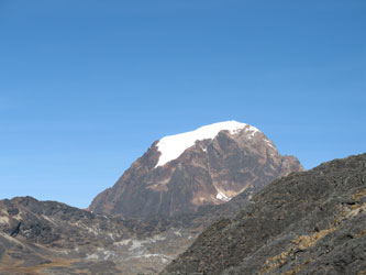
 We lost enough altitude to regain some of the smells of the outdoors and again see a few of the small trees that grow in the Apolobamba. We also noted the increasing amount of grass and the bromeliads that cling to the sides of the rock walls, displaying their pretty red flowers. We dropped and dropped and dropped until the floor of the valley was visible and we contoured east to the grassy campsite known as Incacancha. This would have been a good place to stop and we did in fact stop in the soft grass for about 1/2 hour before saddling up for the climb up the other side of the canyon. We'd covered a long way already but it was to early to call it a day. Alcides had noted the route to follow before we dropped down and noted that the next pass to be crossed was the one visible at the top of the canyon . . . the far wall of the canyon. We lost enough altitude to regain some of the smells of the outdoors and again see a few of the small trees that grow in the Apolobamba. We also noted the increasing amount of grass and the bromeliads that cling to the sides of the rock walls, displaying their pretty red flowers. We dropped and dropped and dropped until the floor of the valley was visible and we contoured east to the grassy campsite known as Incacancha. This would have been a good place to stop and we did in fact stop in the soft grass for about 1/2 hour before saddling up for the climb up the other side of the canyon. We'd covered a long way already but it was to early to call it a day. Alcides had noted the route to follow before we dropped down and noted that the next pass to be crossed was the one visible at the top of the canyon . . . the far wall of the canyon.
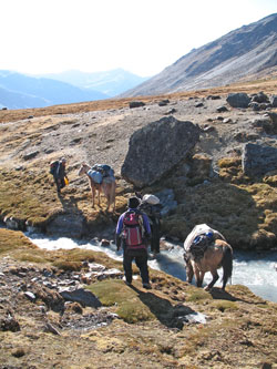
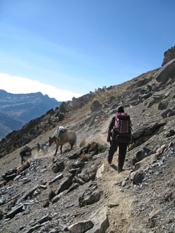
The brief rest felt good and the horses took in some grass and water during the break but soon enough we all saddled up to get the remaining climb over with. A steady ascent all morning followed by the loss of 2500 or more feet just seemed to tell my body and psyche that the worst was over. But it wasn't, we had to gain every bit of the 2500 feet back and then get some more after that as the true pass was not just at the crest of the canyn wall. We crossed the stream at the base of the valley and started up. Unfortunately, the trail was not real clear, not as in not knowing where to go, but as in which faint llama trail do you select to crawl along in order to gain elevation without expending any more effort than need be. However, after about 300 vertical feet, the braided trail traces merge into a defined path . . . up you go.
 We climbed, one rest step at a time, until we made the high point that we had seen from the far side. By this time it was later in the afternoon and the cold mists were filling the valley and bringing more than a casual chill to the air. The weather was changing . . . there was the feel of snow in the air. The fog came in thick as we crested the canyon and the visibility dropped to perhaps 50 feet, at most. Alcides and Mario would appear and disappear as they moved steadily along but generally the only sign that we were not a lone traveling pair were the hoof marks left in the trail below our feet. The pass proper was not at the canyon crest but yet another mile along the still ascending terrain that separated the Incacancha canyon from the next one we would descend into. We climbed, one rest step at a time, until we made the high point that we had seen from the far side. By this time it was later in the afternoon and the cold mists were filling the valley and bringing more than a casual chill to the air. The weather was changing . . . there was the feel of snow in the air. The fog came in thick as we crested the canyon and the visibility dropped to perhaps 50 feet, at most. Alcides and Mario would appear and disappear as they moved steadily along but generally the only sign that we were not a lone traveling pair were the hoof marks left in the trail below our feet. The pass proper was not at the canyon crest but yet another mile along the still ascending terrain that separated the Incacancha canyon from the next one we would descend into.
 We reached the pass proper, as indicated by yet another pile of stones, and we added our own sign of passing. Word has it that doing so is good luck and given the fog and drizzle that now enveloped us, I was hoping for a touch of luck in the weather department. Our entire trip had been one of sunny days, afternoon fog and cold nights, all OK by us and entirely proper for winter in the Apolobamba. But we had heard that that the Apolobamba could be wet and less placid than other ranges and this looked like a touch of that other personality. The good news was that our camp would be lower and if there was a snow line that evening, we would hopefully be below it. We reached the pass proper, as indicated by yet another pile of stones, and we added our own sign of passing. Word has it that doing so is good luck and given the fog and drizzle that now enveloped us, I was hoping for a touch of luck in the weather department. Our entire trip had been one of sunny days, afternoon fog and cold nights, all OK by us and entirely proper for winter in the Apolobamba. But we had heard that that the Apolobamba could be wet and less placid than other ranges and this looked like a touch of that other personality. The good news was that our camp would be lower and if there was a snow line that evening, we would hopefully be below it.
 We descended to the camp at Jatunpampa, first through a series of switchbacks and then traversing across an alpine flat to another pile of rocks and then a pre-Columbian road that dropped into the valley before us. We kept moving, dropping slowly down through the cloud base and after perhaps another 20 to 30 minutes we arrived at the Jatunpampa camp beside a large haystack shaped rock. We set up the tents and settled in for some dinner as the clouds now dropped a steady rain down upon us. However, we were dry and regardless of the weather, we were within just a few hours of Curva and Charazani the next day. Behind us lay the better part of 12 or 15 miles of trail, four passes and a solid 8 hour trek. We descended to the camp at Jatunpampa, first through a series of switchbacks and then traversing across an alpine flat to another pile of rocks and then a pre-Columbian road that dropped into the valley before us. We kept moving, dropping slowly down through the cloud base and after perhaps another 20 to 30 minutes we arrived at the Jatunpampa camp beside a large haystack shaped rock. We set up the tents and settled in for some dinner as the clouds now dropped a steady rain down upon us. However, we were dry and regardless of the weather, we were within just a few hours of Curva and Charazani the next day. Behind us lay the better part of 12 or 15 miles of trail, four passes and a solid 8 hour trek.
|
