UN 13,631 a.k.a. "Anderson Peak"
Telluride Creek / Enterprise Mine Road- June 17, 2013
I was told by a friend that the reason to climb Centennials and Bicentennials is to introduce one to new valleys and other portions of familiar ranges that one's quest for the 14'ers left out of the mix. The lure of a remote Bicentennial drew me from Cheyenne (not hard to do, I assure you) on this June Saturday afternoon to make the rather long trip to the Telluride Creek trailhead. I wasn't solo, my wife and I have a deal, she tags along and we make a slow touristy stop here and there trip to the trail head and while I do the alpine start, she sleeps in while I climb.
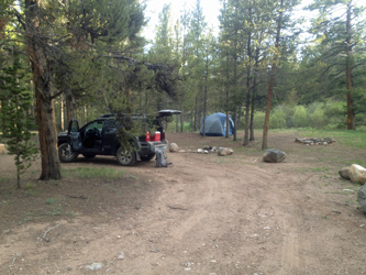 The trip from Buena Vista to the trailhead is no short haul, every bit of a 40 mile jaunt across Cottonwood Pass and on to the far side of the Sawatch. The drive over was uneventful but for one putz crawling along with a trailer loaded with 4 wheelers . . . a putz who just could not grasp the concept of allowing faster traffic to pass. He eventually failed to maintain adequate guard and as a result will take his due share of Colorado dust back to his home state located on the Pacific coast, south of Oregon. After crossing the pass we passed the Taylor Reservoir and went about 9 miles further to the Tellurium Creek road, where we found a camp spot abut a quarter mile off the main road. The trip from Buena Vista to the trailhead is no short haul, every bit of a 40 mile jaunt across Cottonwood Pass and on to the far side of the Sawatch. The drive over was uneventful but for one putz crawling along with a trailer loaded with 4 wheelers . . . a putz who just could not grasp the concept of allowing faster traffic to pass. He eventually failed to maintain adequate guard and as a result will take his due share of Colorado dust back to his home state located on the Pacific coast, south of Oregon. After crossing the pass we passed the Taylor Reservoir and went about 9 miles further to the Tellurium Creek road, where we found a camp spot abut a quarter mile off the main road.
 Nice spot . . . but for the prior users believing that the proper disposal method for a couple of bags of shit from their porta potty was a shallow burial for the local critters to dig up. I had a large trash bag and with the aid of stick, we left the site in better shape than what we found. Yes, for those who read my site on a regular basis, it is time for my annual rant as to the reprobates that who rightly should not have proceeded beyond being a brown stain on a mattress. I am one of those guys who picks up aluminum cans, fragments of clay pigeons, pistol and rifle brass, beer bottles and yes, using a stick, I'll even pick up a couple of bags of shit here and there to leave the site in better shape than I find it . . . every time. For the life of me, I do not understand the mentality of those who abuse our National Forests, given the degree of respect that I have for the resource. Enough of the rant . . . I'm done for 2013. Nice spot . . . but for the prior users believing that the proper disposal method for a couple of bags of shit from their porta potty was a shallow burial for the local critters to dig up. I had a large trash bag and with the aid of stick, we left the site in better shape than what we found. Yes, for those who read my site on a regular basis, it is time for my annual rant as to the reprobates that who rightly should not have proceeded beyond being a brown stain on a mattress. I am one of those guys who picks up aluminum cans, fragments of clay pigeons, pistol and rifle brass, beer bottles and yes, using a stick, I'll even pick up a couple of bags of shit here and there to leave the site in better shape than I find it . . . every time. For the life of me, I do not understand the mentality of those who abuse our National Forests, given the degree of respect that I have for the resource. Enough of the rant . . . I'm done for 2013.
 We pitched camp and were both tired so we were in the tent by 8:30 and I had the alarm set for 4:00, figuring that I had a seven hour climb in front of me and that I'd like to be back by noon. The night was warm and I slept well, until the alarm went off, and I had to motivate myself to get up and going. I had the iPod and with it the promise of a good book on tape, which is my diversion when hiking solo before the sun is up and the solar prozac brings me into a motivated and . . . hospitable state of mind. I was on the road by 4:30 and putting one foot in front of the other until I came to a point where the creek was, in part, running down the road. It was still dark and I knew I had a creek crossing in the cards, water on the road was a sure sign I was getting close. We pitched camp and were both tired so we were in the tent by 8:30 and I had the alarm set for 4:00, figuring that I had a seven hour climb in front of me and that I'd like to be back by noon. The night was warm and I slept well, until the alarm went off, and I had to motivate myself to get up and going. I had the iPod and with it the promise of a good book on tape, which is my diversion when hiking solo before the sun is up and the solar prozac brings me into a motivated and . . . hospitable state of mind. I was on the road by 4:30 and putting one foot in front of the other until I came to a point where the creek was, in part, running down the road. It was still dark and I knew I had a creek crossing in the cards, water on the road was a sure sign I was getting close.
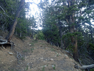
 The crossing came after about 100 yards of hugging the edge to keep the feet dry. There was no obvious crossing upstream, and none downstream either. "Oh, now wait a minute, there is something seriously horizontal up there there in the shadows" I thought. yes, a no old two log bridge, no longer level or seriously stable but good enough for my needs. I was soon across and on my way up the road for another mile or so until I reached the split in the road that I needed not to miss and which right fork I wanted to take. I had read a trip report that told of the road, from this point on to well above tree line, being subject to miles of backhoe bucket scoops being taken in what logically was an effort to reclaim the road. Well, prior reports and photos do not lie, the road is a sometimes, most times, frustrating course to travel. The crossing came after about 100 yards of hugging the edge to keep the feet dry. There was no obvious crossing upstream, and none downstream either. "Oh, now wait a minute, there is something seriously horizontal up there there in the shadows" I thought. yes, a no old two log bridge, no longer level or seriously stable but good enough for my needs. I was soon across and on my way up the road for another mile or so until I reached the split in the road that I needed not to miss and which right fork I wanted to take. I had read a trip report that told of the road, from this point on to well above tree line, being subject to miles of backhoe bucket scoops being taken in what logically was an effort to reclaim the road. Well, prior reports and photos do not lie, the road is a sometimes, most times, frustrating course to travel.
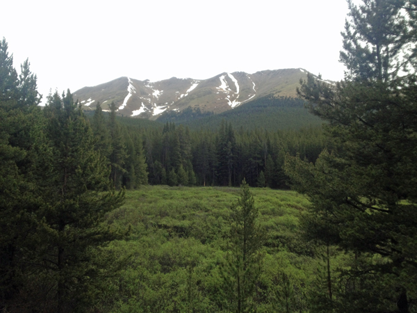
 The road initially cuts around a boggy area before heading uphill, a direction it continues to take until well over 12,000 in elevation. the course is through trees and the road was once quite a wide route. One can hike the edge of the road through the trees as there is virtually no under story at all, but over the course of years, there has been enough traffic that a worn course winds its way through and around the potholes. I didn't see signs of human traffic as all of the tracks had cloven hooves (Centaur traffic?) and left these piles of brown pellets along the way. Over the course of time the elk have tracked a good course and I usually took advantage of their efforts. The road initially cuts around a boggy area before heading uphill, a direction it continues to take until well over 12,000 in elevation. the course is through trees and the road was once quite a wide route. One can hike the edge of the road through the trees as there is virtually no under story at all, but over the course of years, there has been enough traffic that a worn course winds its way through and around the potholes. I didn't see signs of human traffic as all of the tracks had cloven hooves (Centaur traffic?) and left these piles of brown pellets along the way. Over the course of time the elk have tracked a good course and I usually took advantage of their efforts.
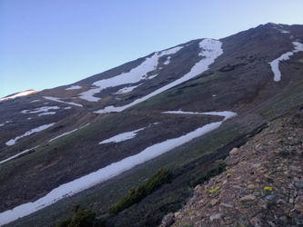
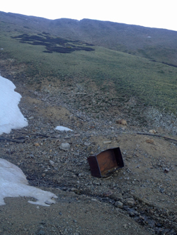
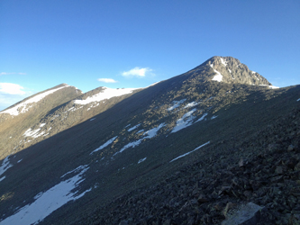
 There are multiple sites that have mine ruins as one climbs upward and the trees thin out. After perhaps a mile and a half, tree line is reached and the road can be seen traversing at a steep angle up the flank of the peak, headed for a couple of large muck piles. At this point it was time to stop for a good snack before taking on the last mogul run before the climb to the summit. Up an down, in and out, I hiked up that darned road until I reached the substantive muck pile where a 3 ton tram car lay on it side in the midst of twisted rail but little else. I climbed a few more switchbacks and arrived at the end of the road, nothing but good old fashioned talus ahead! There are multiple sites that have mine ruins as one climbs upward and the trees thin out. After perhaps a mile and a half, tree line is reached and the road can be seen traversing at a steep angle up the flank of the peak, headed for a couple of large muck piles. At this point it was time to stop for a good snack before taking on the last mogul run before the climb to the summit. Up an down, in and out, I hiked up that darned road until I reached the substantive muck pile where a 3 ton tram car lay on it side in the midst of twisted rail but little else. I climbed a few more switchbacks and arrived at the end of the road, nothing but good old fashioned talus ahead!
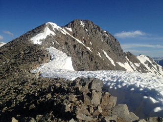
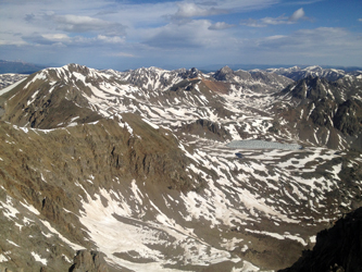
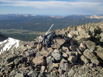 The only thing separating me from the ridge that would lead to the summit was about 300 to 400 feet of vertical to be surmounted via a talus slope. There was no obvious trail, so I picked my way upward in a climbing traverse to to the ridge saddle that separates the summit of Anderson peak from another point on the ridge to the east. Once I arrived on the saddle, there was a climber's trace that ran the crest of the ridge and climbed upward toward the summit to my left. The route to the summit involved a class 2 climb to a short flat and then another class 2 climb to the highest point. The actual highpoint is reached by traversing another 100 75 feet along the summit crest to a pile of rocks and register tube. I reached the highpoint and sat down to rest and watch the formerly clear view of the Elk Range succumb to clouds and the signs of a thunderstorm headed in my general direction. The only thing separating me from the ridge that would lead to the summit was about 300 to 400 feet of vertical to be surmounted via a talus slope. There was no obvious trail, so I picked my way upward in a climbing traverse to to the ridge saddle that separates the summit of Anderson peak from another point on the ridge to the east. Once I arrived on the saddle, there was a climber's trace that ran the crest of the ridge and climbed upward toward the summit to my left. The route to the summit involved a class 2 climb to a short flat and then another class 2 climb to the highest point. The actual highpoint is reached by traversing another 100 75 feet along the summit crest to a pile of rocks and register tube. I reached the highpoint and sat down to rest and watch the formerly clear view of the Elk Range succumb to clouds and the signs of a thunderstorm headed in my general direction.
 I left the standard gummy bear offering to Pachamama and finished off a sleeve of Girl Scout Thin mints before hefting the pack for the trip back down. I'm not a signer of registers but I was curious when the last person had signed so I took a look see and was surprised to see no registered visits since the middle of September 2012. The climb up took mea bit over 4 hours and I figured I'd have no less than two and half hours in the trip back down. My descent was simple reversal of course though I'd considered a more direct route down a steep and then shallow couloir that led down to tree line and a sure intercept with the road as it cut back toward the boggy section. I had dark skies on the horizon but not moving so quickly that a bail out was in order, so I hoofed the road on back down in lieu of a direct decent. At a bit before 11:30, I was back at camp and we were soon ready to motorvate to BV for a quick snack before taking our assigned position in the I-70 parking lot. I left the standard gummy bear offering to Pachamama and finished off a sleeve of Girl Scout Thin mints before hefting the pack for the trip back down. I'm not a signer of registers but I was curious when the last person had signed so I took a look see and was surprised to see no registered visits since the middle of September 2012. The climb up took mea bit over 4 hours and I figured I'd have no less than two and half hours in the trip back down. My descent was simple reversal of course though I'd considered a more direct route down a steep and then shallow couloir that led down to tree line and a sure intercept with the road as it cut back toward the boggy section. I had dark skies on the horizon but not moving so quickly that a bail out was in order, so I hoofed the road on back down in lieu of a direct decent. At a bit before 11:30, I was back at camp and we were soon ready to motorvate to BV for a quick snack before taking our assigned position in the I-70 parking lot.
|
