Hagerman Peak
September 11, 2011 - South Ridge
G, Bob and I needed to get out for a good September car camping/climbing trip and I was looking to tick off one last Centennial for the year. The timing was right . . . we also tend to make an annual pilgrimage to the Elks every fall and if we can time it right . . . we try to catch the aspen during the change of colors. Since I "needed" two Elk Range Centennials, Hagerman and Thunder Pyramid, and since there was no way I was going to do Thunder Pyramid on rock when it is such an inviting snow climb, we opted for a trip to Lead King Basin and Hagerman Peak.
 We left Cheyenne at noon on Saturday . . . (clearly the makings of a true "turbo" trip) . . . and arrived in Glenwood at about 4:30 for dinner. With good mexican food consumed, we set camp at the USFS Bogan Flats campground, a few miles shy of Marble. Tents went up, a 750 ml. bottle of Baileys came out, and by 8:30 we were not only ready for the sleeping bags but quite mellow as well. We agreed that 4:00 a.m. would be zero hour and we hoped to drive all the way to the 4WD trailhead at the head of Lead King Basin. We left Cheyenne at noon on Saturday . . . (clearly the makings of a true "turbo" trip) . . . and arrived in Glenwood at about 4:30 for dinner. With good mexican food consumed, we set camp at the USFS Bogan Flats campground, a few miles shy of Marble. Tents went up, a 750 ml. bottle of Baileys came out, and by 8:30 we were not only ready for the sleeping bags but quite mellow as well. We agreed that 4:00 a.m. would be zero hour and we hoped to drive all the way to the 4WD trailhead at the head of Lead King Basin.
We were up with a minimum of fuss and literally had the tents down and the truck on the road at 4:30. We passed through Marble and proceeded to Crystal town site and the 2WD trail head, which lies at the end of the rough dirt road from Marble. At the 2WD trail head there was a sign warning of the rough character of the remaining 2 miles to the 4 WD trail head. This is the same general message one gets at the start of the Holy Cross jeep trail but in this case, the message turned out to be flat out unadulterated bullshit on the part of the clowns who put up the sign. I could have driven the next two miles in my stock Tacoma and not even caused my non 4WD wife a moment's angst.
 With the Holy Cross sign in mind, we parked at the 2WD trail head and hefted the packs for the two mile hike to the head of Lead King Basin. The road march went quickly, kind of like walking up my driveway, and we covered the distance in an hour or so. The sun rose as we hiked along, illuminating a pretty solid ceiling of dark gray clouds, leading us to wonder if the weather would allow for our intended route up Hagerman, the less traveled Southwest Ridge. We arrived at the 4WD trailhead to find six stock Toyota and Nissan trucks and SUV's, proving the point that the bad road warnings were little more than With the Holy Cross sign in mind, we parked at the 2WD trail head and hefted the packs for the two mile hike to the head of Lead King Basin. The road march went quickly, kind of like walking up my driveway, and we covered the distance in an hour or so. The sun rose as we hiked along, illuminating a pretty solid ceiling of dark gray clouds, leading us to wonder if the weather would allow for our intended route up Hagerman, the less traveled Southwest Ridge. We arrived at the 4WD trailhead to find six stock Toyota and Nissan trucks and SUV's, proving the point that the bad road warnings were little more than 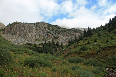 wives' tales. wives' tales.
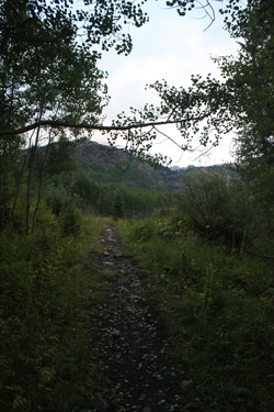
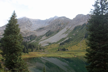
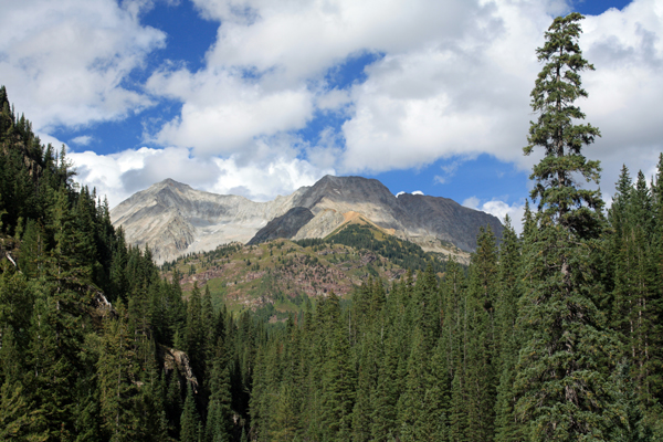
We easily located the trail and continued hiking up valley, planning to take the route that circled Geneva Lake and then cut around via the path to Trail Rider Pass. The route to the lake first led through a grove of aspen before coming out into the open near a very scenic waterfall dropping from the headwall of the hanging valley that holds Geneva Lake. The trail turned back to switchback multiple times, allowing us to gain the 500 feet or so that we needed to arrive at the top of the falls. Form there it was just a few more minutes walk to Geneva Lake, which we circled on the left side. We took our first break of the climb about half way around the lake and watched the clouds lift in some areas 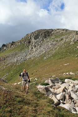 but generally remain in place around the summit of Hagerman Peak. but generally remain in place around the summit of Hagerman Peak.
We were off again after but a few minutes and headed around the remainder of the lake, picking up the route to Trail Rider Pass with little difficulty. The trail led around the base of the high ground that eventually climbs to form Hagerman's 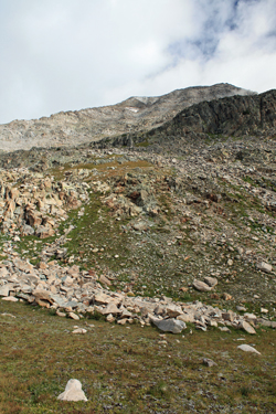 Southwest Ridge and took us on a gentle up and down course through groves of pine and a meadow or two before hooking down and around to intercept the small stream noted on the maps as the approach to either the ridge or more customary face route. Our arrival at the junction gave us a chance to decide if the ridge route was a viable choice, given the increasing cloud cover and falling barometer. We gave the clouds a hard look and as the west was pretty dark, we opted for the easier route, knowing that the ridge would offer but one or two escape routes and the promise of rain and/or snow on an exposed stretch of class 3 terrain was not the most enchanting idea. Southwest Ridge and took us on a gentle up and down course through groves of pine and a meadow or two before hooking down and around to intercept the small stream noted on the maps as the approach to either the ridge or more customary face route. Our arrival at the junction gave us a chance to decide if the ridge route was a viable choice, given the increasing cloud cover and falling barometer. We gave the clouds a hard look and as the west was pretty dark, we opted for the easier route, knowing that the ridge would offer but one or two escape routes and the promise of rain and/or snow on an exposed stretch of class 3 terrain was not the most enchanting idea.
For us it would be the face route this morning. so up the stream course we went, starting on the trail to the left and eventually climbing up through the stream bed proper before picking up mixed segments further along. Within no more than ten minutes of climbing, we exited the stream and took the obvious mixed rock and grass 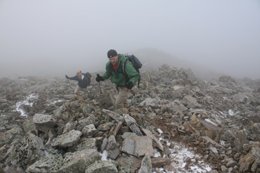 slope that would lead to an upper basin and the start of the face climb in earnest. Once through this gully, we arrived at the flat grassy knoll spoken of in the guide where we adjusted layers in the face of oncoming precipitation. The next leg called for a short winding climb to the top of another flat, no more the 75 vertical feet and then a climb of a short headwall, first by talus hopping and then by short rock steps through one of a couple of breaks in this short semi cliff face. slope that would lead to an upper basin and the start of the face climb in earnest. Once through this gully, we arrived at the flat grassy knoll spoken of in the guide where we adjusted layers in the face of oncoming precipitation. The next leg called for a short winding climb to the top of another flat, no more the 75 vertical feet and then a climb of a short headwall, first by talus hopping and then by short rock steps through one of a couple of breaks in this short semi cliff face.
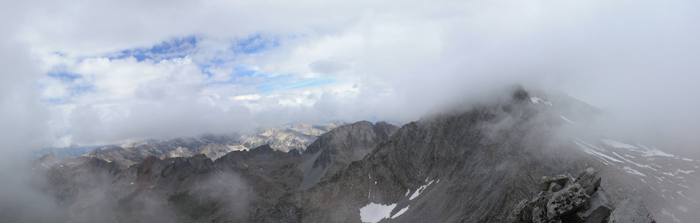
 After topping the short cliffs, we had only to ascend one of the couple of wide gullies that led to the summit, a climb of perhaps 1800 feet lay before us. We rest stepped onward and upward, putting up with a mix of sunny spots, a bit of rain lower down and multiple snow showers as we climbed. There was nothing exciting about this portion of the climb, simply a case of one foot in front of another as the altimeters ticked off the ascent. We exchanged leads back and forth, not on purpose but simply the result of one or the other taking a different course through the braided climber's trails that cut upward through base of our chosen swale. As we came within one hundred or so vertical feet of the summit ridge, the terrain steepened to Class 2+ or Class 3, the "3" route being ur deliberate choice, but it did not last long as we were soon on the summit ridge, veiled in cloud. After topping the short cliffs, we had only to ascend one of the couple of wide gullies that led to the summit, a climb of perhaps 1800 feet lay before us. We rest stepped onward and upward, putting up with a mix of sunny spots, a bit of rain lower down and multiple snow showers as we climbed. There was nothing exciting about this portion of the climb, simply a case of one foot in front of another as the altimeters ticked off the ascent. We exchanged leads back and forth, not on purpose but simply the result of one or the other taking a different course through the braided climber's trails that cut upward through base of our chosen swale. As we came within one hundred or so vertical feet of the summit ridge, the terrain steepened to Class 2+ or Class 3, the "3" route being ur deliberate choice, but it did not last long as we were soon on the summit ridge, veiled in cloud.
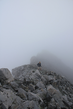
I had no doubt of our location on the summit ridge but as to the summit proper there wa a slight problem . . . we could neither summit nor anything else beyond about 50 yards from where we were. I suggested to Bob that we wend our way north for a bit in the hope that the clouds might lift for just a bit so we could gauge 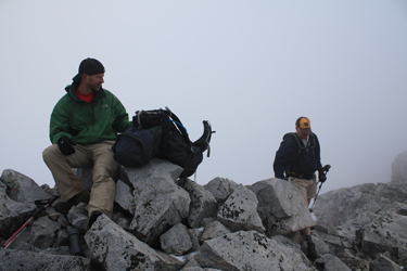 our position. Sure enough, after about 5 minutes, there was a ten second lift and there, about 100 yards ahead of us, was the summit, confirmed by the arrival of the Southwest Ridge. We all three made our way to the high point and sat for about 15 minutes to take some photos, eat some lunch and hope for a bit of sun or a cloud free moment to take in the surroundings. After ten minutes or so, we were rewarded for our patience as the clouds lifted and the Elks to the north were bathed in light and the summit of Snowmass even made a brief appearance. our position. Sure enough, after about 5 minutes, there was a ten second lift and there, about 100 yards ahead of us, was the summit, confirmed by the arrival of the Southwest Ridge. We all three made our way to the high point and sat for about 15 minutes to take some photos, eat some lunch and hope for a bit of sun or a cloud free moment to take in the surroundings. After ten minutes or so, we were rewarded for our patience as the clouds lifted and the Elks to the north were bathed in light and the summit of Snowmass even made a brief appearance.
At this point, we all were starting to chill so we packed the extra layers away and made our way from the summit back across the ridge to the head of the wide descent route. The upper class 2+ terrain was easily descended, followed by
another 800 feet of descent before the sun came out to stay, most of the clouds moved on and we figured we'd score a dry and warm hike out to the truck, about 7 miles distant. Did I mention that b.s. sign that added four 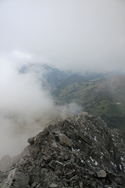 miles to our trip? We took our next break above the short headwall before settling in for the long, but really quite nice, hike back to the 2WD trail head. We passed back through the grass and rock filled gully, made short work of the stream bed to the Trail Rider Pass trail and then opted to descend into Fravert Basin instead of repeating the route back around Geneva lake. miles to our trip? We took our next break above the short headwall before settling in for the long, but really quite nice, hike back to the 2WD trail head. We passed back through the grass and rock filled gully, made short work of the stream bed to the Trail Rider Pass trail and then opted to descend into Fravert Basin instead of repeating the route back around Geneva lake.
The trail down into the basin provided a rapid descent through aspen not yet thinking about a change of color. But for a few small and battered trees, the aspen were green and clearly getting at least one more week of summer green in before the explosion of fall colors that will surely accent this already beautiful valley. We dropped to the valley floor, cut a mile or so over to the base of the waterfall descending from 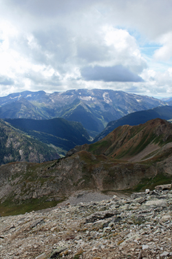 Geneva Lake and then fast marched toward the 4WD trail head, at least until I came face to face with the biggest porcupine I'd ever seen. This fellow was ready without a doubt for winter and as we both came to a mutual stop about 20 feet distant from one another, the question was who would yield the trail. The stare down lasted about 45 seconds before the better armed fellow opted to exit trail left and let us pass. Geneva Lake and then fast marched toward the 4WD trail head, at least until I came face to face with the biggest porcupine I'd ever seen. This fellow was ready without a doubt for winter and as we both came to a mutual stop about 20 feet distant from one another, the question was who would yield the trail. The stare down lasted about 45 seconds before the better armed fellow opted to exit trail left and let us pass.
The 4WD terminus came within a few more minutes and marked a good point to stop and eat a bit before hiking the last two miles to the end of the climb. Those two miles went fast and at 4:20, we were back at the truck, having scored the summit despite the snow showers and having covered about 15 miles and 5000 vertical feet in a bit over ten hours.
|
