Pts. 13,832 & 13,811
July 10, 2010 - via Silver Creek
(see page for Redcloud climb for photos from trailhead to Redcloud saddle)
The day before this climb, I summitted Half Peak via the Cataract Lake approach and I was a bit stiff when the alarm woke me at 4 a.m. But . . . I'd had a great dinner the night before and a good night's sleep . . . I was, at least mentally, ready for a long ridge run. Little did I know just how long this run would be.
 I was headed for the Silver Creek trail head within just a few minutes. The trip to the start of the climb took about a half hour from the Mill Creek Campground, including about a half dozen courtesy "pull over and douse the headlights" pauses for participants in the Hardrock 100 endurance race. I figured if they were willing to go that far, the least I could do was pull over when they got close, sans lights, to spare their night vision and not raise any dust. I was headed for the Silver Creek trail head within just a few minutes. The trip to the start of the climb took about a half hour from the Mill Creek Campground, including about a half dozen courtesy "pull over and douse the headlights" pauses for participants in the Hardrock 100 endurance race. I figured if they were willing to go that far, the least I could do was pull over when they got close, sans lights, to spare their night vision and not raise any dust.
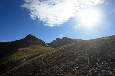
I was away from the trail head before the coming of dawn and making my way up the trail that I recalled from a climb of Redcloud and Sunshine ten years before. The course started off going steeply uphill and then into the trees 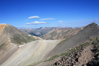 for perhaps a mile of so. I noted on my departure that there would be no lack of company at least as far as the saddle, where one must choose right, for 14'ers, or left, for 13'ers.
The darkness behind me bobbed with the headlights of groups getting ready for a 14'er climb in the trail head meadow that had no less than a dozen vehicles with tents staked in close proximity. I don't think I'd gone more than 100 yards before the first gaggle of cotton clad early risers hustled past me en route to the summit far above. for perhaps a mile of so. I noted on my departure that there would be no lack of company at least as far as the saddle, where one must choose right, for 14'ers, or left, for 13'ers.
The darkness behind me bobbed with the headlights of groups getting ready for a 14'er climb in the trail head meadow that had no less than a dozen vehicles with tents staked in close proximity. I don't think I'd gone more than 100 yards before the first gaggle of cotton clad early risers hustled past me en route to the summit far above.
I made slow time through the trees, taking in the momentary joy of occaisional trail sections that were flat or in a case or two sloped down for just a short bit. But, every flat gave way to another upward pitch, which I knew had to be the case if I ever 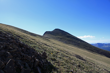 expected to break tree line. It was half light when I got to the trees and passed the expected snowbank that bridged the creek, a remnant of winter activity
in the avi trough that led upward from the opposite bank. The route through this portion was well graded and passed through multiple talus fans before taking a steep pitch or two to land me in the more grassy and mellow upper part of the valley. Another group passed and then another, but I was in no hurry as I knew about the likely outcome, which I expected would be later evidenced by the "out" marks on the trail register. expected to break tree line. It was half light when I got to the trees and passed the expected snowbank that bridged the creek, a remnant of winter activity
in the avi trough that led upward from the opposite bank. The route through this portion was well graded and passed through multiple talus fans before taking a steep pitch or two to land me in the more grassy and mellow upper part of the valley. Another group passed and then another, but I was in no hurry as I knew about the likely outcome, which I expected would be later evidenced by the "out" marks on the trail register.
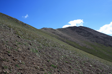
 The trail through the upper valley gently climbed and turned to give a view of the saddle that connects the ridge on which the 14'ers and 13's are located. I arrived at the slopes just below the saddle and noted that the trail had been relocated and that the trip up the slope proper would be by way of a widely switchbacked course rather than the erosion prone direct assault of yesteryear . . . good, no very good by me. I reached the saddle and noted a line of climbers heading up the flank of Redcloud but that was not to be my route this morning. No, I was going to exit saddle left and make my way on up to Point 13,832 and, if the weather held, on across to Pt. 13,811 before retracing my course back to the saddle. The trail through the upper valley gently climbed and turned to give a view of the saddle that connects the ridge on which the 14'ers and 13's are located. I arrived at the slopes just below the saddle and noted that the trail had been relocated and that the trip up the slope proper would be by way of a widely switchbacked course rather than the erosion prone direct assault of yesteryear . . . good, no very good by me. I reached the saddle and noted a line of climbers heading up the flank of Redcloud but that was not to be my route this morning. No, I was going to exit saddle left and make my way on up to Point 13,832 and, if the weather held, on across to Pt. 13,811 before retracing my course back to the saddle.
The first part of the ridge run is just a trail hike along the spine of the ridge until I neared the flank of a rock point that I sough to skirt via the base. I found an obvious trail across the talus and cut first on a level path and then, at the far end, on an upward traverse to the next saddle. From a distance, the route is not really clear, but for every forward step, I gained a bit more insight as to where the trail was going to lead. The guides say this is a Class 1 climb and it is, but the route does not always reveal its gentle nature until you approach the apparent crux. From the small saddle, I took a climbing traverse to a knob of rock and landed in a Class 1 wonderland on the far side, a nice climbers path that gently ascended along the back side of the summit of Pt. 13,832.
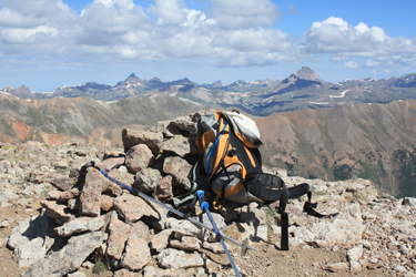
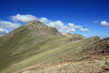 I traversed a bit past the summit and then realized that one or more of the "goat trails" that cut up from my course were leads to the summit. I snagged the next left exit and within no more than 75 feet of vertical, I was on the summit, solo and without another climber in sight. I snacked on a banana, shot a Gu and sipped Cytomax. I traversed a bit past the summit and then realized that one or more of the "goat trails" that cut up from my course were leads to the summit. I snagged the next left exit and within no more than 75 feet of vertical, I was on the summit, solo and without another climber in sight. I snacked on a banana, shot a Gu and sipped Cytomax.
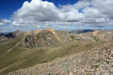
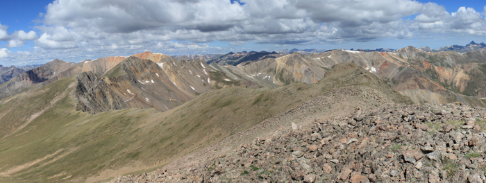
The route from the Redcloud saddle had offered a few surprises but was direct and really little more than a stroll. However as tame as the course along the backside of these points is, the front side is comprised of sharp cliffs and a far drop to the valley below. I took in the view both down and up as I now had to decide if I wanted to make the hike to Pt. 13,811, no less than a mile distant.
 Ten years ago, I turned right at the Redcloud saddle, summitted and then made the decision to make the traverse to Sunshine . . . in the face of clouds building over the Weminuche. The result was that those clouds became electrical storms and I got my butt run back across the connecting ridge by the fireworks. I stood on the summit of Pt. 13,832 and remembered that run very well. Now here I was and there were clouds in the sky, would they signal a second round to my lesson or would they simply sweep by without issue?
It was still quite early and there was no sign that the white puffs were towering, just a relatively thin set of clouds moving by on a lazy wind. I decided to connect the points but with the proviso that if the sky began to show signs of threat, the gig was up and the retreat was on. Ten years ago, I turned right at the Redcloud saddle, summitted and then made the decision to make the traverse to Sunshine . . . in the face of clouds building over the Weminuche. The result was that those clouds became electrical storms and I got my butt run back across the connecting ridge by the fireworks. I stood on the summit of Pt. 13,832 and remembered that run very well. Now here I was and there were clouds in the sky, would they signal a second round to my lesson or would they simply sweep by without issue?
It was still quite early and there was no sign that the white puffs were towering, just a relatively thin set of clouds moving by on a lazy wind. I decided to connect the points but with the proviso that if the sky began to show signs of threat, the gig was up and the retreat was on.
 Connecting these two Points is not a minor league walk . . . it is a long haul down the flank of Pt. 13,832, up and round the back of an intermediate point and then back down to another connecting saddle and then on up to the summit of Pt. 13,811. The vertical for a climb of Pt. 13,832 alone was a bit over 3,400 feet but adding the second point takes the score up to about 4,700 feet. I am not a huge fan of climbing post summit and this connection was going to offer another 1300 feet of just that. I skirted the intermediate point, trying not to gain too much elevation but for every foot pushed aside, there was a price to be paid in an ever growing length of the course that is needed for a zero gain traverse. I split the difference and circled perhaps 100 vertical feet below the intermediate point before dropping down to the next saddle. Connecting these two Points is not a minor league walk . . . it is a long haul down the flank of Pt. 13,832, up and round the back of an intermediate point and then back down to another connecting saddle and then on up to the summit of Pt. 13,811. The vertical for a climb of Pt. 13,832 alone was a bit over 3,400 feet but adding the second point takes the score up to about 4,700 feet. I am not a huge fan of climbing post summit and this connection was going to offer another 1300 feet of just that. I skirted the intermediate point, trying not to gain too much elevation but for every foot pushed aside, there was a price to be paid in an ever growing length of the course that is needed for a zero gain traverse. I split the difference and circled perhaps 100 vertical feet below the intermediate point before dropping down to the next saddle.
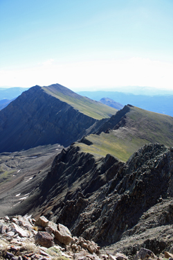
 At this point, I was a bit tired but the clouds were still holding off so I endeavored to make reasonable time to the summit before me. I hung more or less on the ridge line, using a climber's trace where available and rock hopping where there was no obviously trodden course.
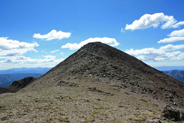
I gained the last mini saddle on the ridge and then breezed along a trail to the summit proper . . . Pt. 13,811 was now in hand. Another couple of sips, a Gu and some photos before I was off to track my way back to the first point and the Redcloud saddle. The clouds were still holding off but the clock was running and I had a long ways to go, all of it above 13k. I easily descended to the first saddle and silently bemoaned the need to climb about 300 vertical to get to the other side of the intermediate hump. I got it over with and then dropped to the next saddle but this time I had to climb to within 75 or 100 vertical of the Pt 13,832 summit. But those feet came easily, I was on the second wind of the descent and without pause I skirted the higher Point and moved on under darkening skies to tread the easy course back toward the talus track and easy hike back to the Redcloud saddle. At this point, I was a bit tired but the clouds were still holding off so I endeavored to make reasonable time to the summit before me. I hung more or less on the ridge line, using a climber's trace where available and rock hopping where there was no obviously trodden course.
I gained the last mini saddle on the ridge and then breezed along a trail to the summit proper . . . Pt. 13,811 was now in hand. Another couple of sips, a Gu and some photos before I was off to track my way back to the first point and the Redcloud saddle. The clouds were still holding off but the clock was running and I had a long ways to go, all of it above 13k. I easily descended to the first saddle and silently bemoaned the need to climb about 300 vertical to get to the other side of the intermediate hump. I got it over with and then dropped to the next saddle but this time I had to climb to within 75 or 100 vertical of the Pt 13,832 summit. But those feet came easily, I was on the second wind of the descent and without pause I skirted the higher Point and moved on under darkening skies to tread the easy course back toward the talus track and easy hike back to the Redcloud saddle.
 I stopped on the saddle to take a few photos and then started on down the trail to the valley below. I made good time and passed a number of cotton clusters on my way out of the upper valley and on down to the distant tree line. I made the trees and within no time was in sight of the trail head, the many vehicles and the ever present red and yellow rental jeeps. I summitted both points in a bit under 8 hours and did so without any of the summer hubbub once past the Redcloud saddle. A good climb. I stopped on the saddle to take a few photos and then started on down the trail to the valley below. I made good time and passed a number of cotton clusters on my way out of the upper valley and on down to the distant tree line. I made the trees and within no time was in sight of the trail head, the many vehicles and the ever present red and yellow rental jeeps. I summitted both points in a bit under 8 hours and did so without any of the summer hubbub once past the Redcloud saddle. A good climb.
|
