Gladstone Peak
North Ridge - August 20, 2011
The deal with Ed is simple . . . I'll repeat 14'ers but along the way we tag the Centennials that I am trying to accrue for my own tick list. Ed was "in need" of the Wilson group of 14'ers and nestled right between Mount Wilson and Wilson peak is Gladstone Peak, a Centennial 13'er. Our plan, if all went well and the weather held, would be to climb both Gladstone Peak and Wilson Peak from the new Silverpick trail head.
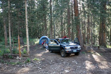 We traveled from the Denver and Cheyenne the day before and staked out a good camp spot along the improved forest road that led to the trail head. The next day, we were up at 4 and on the trail by 4:45, knowing that we first had to cover 3.7 miles to the Rock of Ages Saddle. I'd been there before but that was back in the day of the old trail head and my map reading was telling me that I'd just signed on for about an extra mile in each direction. Regardless, we got a start in the dark and kept a keen eye out for the trail junctures that we'd read of lately as opportunities to not get to the saddle. We traveled from the Denver and Cheyenne the day before and staked out a good camp spot along the improved forest road that led to the trail head. The next day, we were up at 4 and on the trail by 4:45, knowing that we first had to cover 3.7 miles to the Rock of Ages Saddle. I'd been there before but that was back in the day of the old trail head and my map reading was telling me that I'd just signed on for about an extra mile in each direction. Regardless, we got a start in the dark and kept a keen eye out for the trail junctures that we'd read of lately as opportunities to not get to the saddle.
 Our fears were totally unfounded as we walked an old mining road first through the woods and then around the nose of an intermediate ridge to gain the old route up toward the saddle. The new trail was created to avoid private property and though it adds a mile or so I would guess in each direction, it is a pleasant, sometimes steep, but well graded route. We came around the ridge that separates the drainage in which the new trail starts, dropped down just a bit and connected to the old road that I was familiar with from back in about 2002. Our fears were totally unfounded as we walked an old mining road first through the woods and then around the nose of an intermediate ridge to gain the old route up toward the saddle. The new trail was created to avoid private property and though it adds a mile or so I would guess in each direction, it is a pleasant, sometimes steep, but well graded route. We came around the ridge that separates the drainage in which the new trail starts, dropped down just a bit and connected to the old road that I was familiar with from back in about 2002.
 We were now in daylight and as we walked up the road toward some old mining ruins I took in the sweet smell of sulfides oxidizing in the air. As a former mining engineer, I love the smell of "mine air" with its tincture of sulphur to lead one on back down memory lane, with but a touch of rock drill oil being the only missing element. The road climbed steadily and soon we came to a hard switchback to the left where the new trail cut off to switchback to a point just above the old stone bunkhouse that in years past was on our route. We stuck with the private property avoidance program and took the new course,climbing steeply and then traversing along the side of the hill to again intercept the old mining road. We were now in daylight and as we walked up the road toward some old mining ruins I took in the sweet smell of sulfides oxidizing in the air. As a former mining engineer, I love the smell of "mine air" with its tincture of sulphur to lead one on back down memory lane, with but a touch of rock drill oil being the only missing element. The road climbed steadily and soon we came to a hard switchback to the left where the new trail cut off to switchback to a point just above the old stone bunkhouse that in years past was on our route. We stuck with the private property avoidance program and took the new course,climbing steeply and then traversing along the side of the hill to again intercept the old mining road.
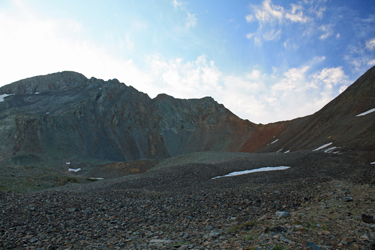
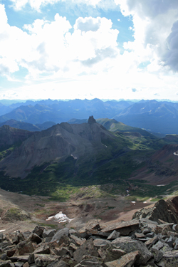
 The mining road eventually climbs to the base of the slope that at its furthest extent is the Rock of Ages saddle. The road does continue but the trail takes a more direct climb and as predicted, again intercepts the road higher up for another hillside traverse before cutting a switchback to give a final leg along the old track. The road at this point has fallen to the vestiges of time and while quite discernable as a road, is The mining road eventually climbs to the base of the slope that at its furthest extent is the Rock of Ages saddle. The road does continue but the trail takes a more direct climb and as predicted, again intercepts the road higher up for another hillside traverse before cutting a switchback to give a final leg along the old track. The road at this point has fallen to the vestiges of time and while quite discernable as a road, is 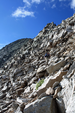 really more of a path due to the scree and talus working to cover the old and wider path. The grade remains a steady upward character and after about fifteen minutes, we arrived at the saddle. Up to this point, the view is of Wilson Peak only but the saddle presents the whole vista, ranging from Wilson Peak to Gladstone and on through Mount Wilson and the connecting ridge to El Diente. really more of a path due to the scree and talus working to cover the old and wider path. The grade remains a steady upward character and after about fifteen minutes, we arrived at the saddle. Up to this point, the view is of Wilson Peak only but the saddle presents the whole vista, ranging from Wilson Peak to Gladstone and on through Mount Wilson and the connecting ridge to El Diente.
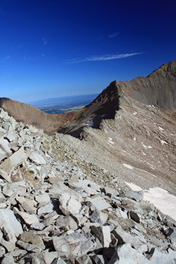 We stopped for about five minutes to take in the view before turning left and starting the hike up to the Wilson/Gladstone saddle. The guide book notes that one can drop to the old mine pad and then aim for the lower point on the connecting ridge, but I'd been up Wilson Peak before and remembered a traveled path heading toward Gladstone. We picked an chose our way to the flank of Wilson Peak and stopped upon arrival to give thought to which peak we would attempt first. Gladstone was the choice as we still had good weather and we figured to get the farther summit first and catch what I remembered to be the easier Wilson Peak summit on the return trip. We stopped for about five minutes to take in the view before turning left and starting the hike up to the Wilson/Gladstone saddle. The guide book notes that one can drop to the old mine pad and then aim for the lower point on the connecting ridge, but I'd been up Wilson Peak before and remembered a traveled path heading toward Gladstone. We picked an chose our way to the flank of Wilson Peak and stopped upon arrival to give thought to which peak we would attempt first. Gladstone was the choice as we still had good weather and we figured to get the farther summit first and catch what I remembered to be the easier Wilson Peak summit on the return trip.
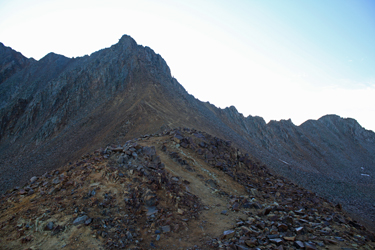
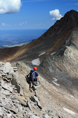
The climbers trail toward Gladstone started strong and petered out in no time flat. After no more than one hundred yards the nature of the climb was apparent, we were going to boulder hop all the way along the ridge until we got to the climb proper. The boulders were generally solid and stable but we had to side hill around the various bumps that make up the 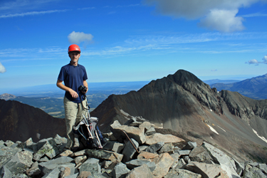 toothy connection between the two peaks. We stuck to the eastern side, there was no choice, and cussed our way along the ridge, mostly losing elevation in the knowledge that we would have to cross the low point that the trail from the other side would have presented us had we chosen the other approach. We found this not to be a route with any diversion or break from the boulders, just a solid uninterrupted exercise in boulder hopping and the occasional reversal caused by the need to drop down when the route forward became too steep or a dead end in the rocks. toothy connection between the two peaks. We stuck to the eastern side, there was no choice, and cussed our way along the ridge, mostly losing elevation in the knowledge that we would have to cross the low point that the trail from the other side would have presented us had we chosen the other approach. We found this not to be a route with any diversion or break from the boulders, just a solid uninterrupted exercise in boulder hopping and the occasional reversal caused by the need to drop down when the route forward became too steep or a dead end in the rocks.
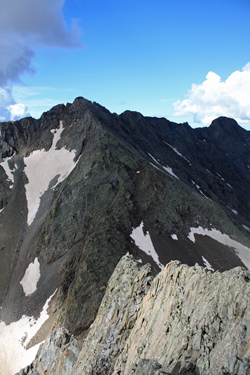 We reached the lowest point in the connecting ridge and started up the slopes of Gladstone proper. I'd heard that the peak had a lot of loose talus and that is an under statement. Gladstone Peak is like a fart, you cannot trust it. With very hundred feet of climb, the handholds get more and more loose and the big rocks tilt and totter more than those below. We climbed the flank, below the ridge proper and found the going a bit stiff with lots of solid class 3 and class 4 ground, all guarded by loose rock. I think both Ed and I set a good bit of small stuff loose and called out to one another when the loose stone was in one case the size of a washer or dryer. We maintained a traversing course, aiming for the summit and picking and choosing routes that would keep us in solid ground where possible. We reached the lowest point in the connecting ridge and started up the slopes of Gladstone proper. I'd heard that the peak had a lot of loose talus and that is an under statement. Gladstone Peak is like a fart, you cannot trust it. With very hundred feet of climb, the handholds get more and more loose and the big rocks tilt and totter more than those below. We climbed the flank, below the ridge proper and found the going a bit stiff with lots of solid class 3 and class 4 ground, all guarded by loose rock. I think both Ed and I set a good bit of small stuff loose and called out to one another when the loose stone was in one case the size of a washer or dryer. We maintained a traversing course, aiming for the summit and picking and choosing routes that would keep us in solid ground where possible.
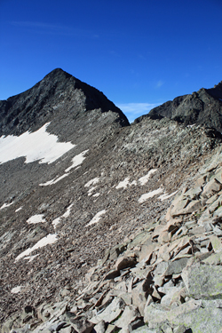
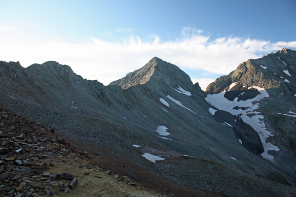
 We climbed toward a point at the easterly edge of the summit proper and as we neared the top the slope lessened a bit and then presented us with a brief class 2 scramble to the summit proper. The view from the top is worth the climb, assuming you are still alive and not pinned below some boulder having the life crushed from your broken frame. The route down toward the connecting saddle with Mount Wilson is some very tough looking ground for sure. Our route up was no charmer either but that was OK, we were headed down the ridge proper for as far as we could in an effort to avoid some of the looser ground we climbed through on the way upward. The ridge gave good footing for about 100 feet of descent before a drop off reminded us that the price for the summit was a retreat through the tougher ground we climbed on the way up. We climbed toward a point at the easterly edge of the summit proper and as we neared the top the slope lessened a bit and then presented us with a brief class 2 scramble to the summit proper. The view from the top is worth the climb, assuming you are still alive and not pinned below some boulder having the life crushed from your broken frame. The route down toward the connecting saddle with Mount Wilson is some very tough looking ground for sure. Our route up was no charmer either but that was OK, we were headed down the ridge proper for as far as we could in an effort to avoid some of the looser ground we climbed through on the way upward. The ridge gave good footing for about 100 feet of descent before a drop off reminded us that the price for the summit was a retreat through the tougher ground we climbed on the way up.
 We picked our way back through the ratty ground, not having any real problem but being careful to stay close and to call out the loose stuff that was large enough to worry about. We prevailed and found ourselves back at the low point of the connecting ridge where we decided to do our best to hold a contour line that looked as if it offered the path a least resistance. The contour proved a friendly path that allowed us to rock hop along a side hill course missing most of the large talus that plagued our approach but still giving us the change to rock hop here and there. We finally crossed around the intermediate points and arrived back at the notch where the trail from the Rock of Ages saddle arrived to meet our course and the regular route up Wilson Peak. We picked our way back through the ratty ground, not having any real problem but being careful to stay close and to call out the loose stuff that was large enough to worry about. We prevailed and found ourselves back at the low point of the connecting ridge where we decided to do our best to hold a contour line that looked as if it offered the path a least resistance. The contour proved a friendly path that allowed us to rock hop along a side hill course missing most of the large talus that plagued our approach but still giving us the change to rock hop here and there. We finally crossed around the intermediate points and arrived back at the notch where the trail from the Rock of Ages saddle arrived to meet our course and the regular route up Wilson Peak.
We came across a fellow sitting at the juncture and chatted with him as we decided whether to move on up the trail to the summit of Wilson Peak. We headed up but that is another climb in and of itself . . .
|
