Pt. 13,626
January 6, 2012 - Grouse Creek Drainage
The weekend weather pattern had been poor of late . . . that was until the first Sunday of the New Year . . . which brought a forecast of a bluebird climbng day. Ed and I had schemed earlier as to getting out and we both had a free weekend on tap. Our opportunity was combined with an on line trip report of a rather intrepid group that tackled Mt Princeton from the backside and, in doing so, solved the route finding dilemma we would have otherwise faced in gaining tree line in the Grouse Creek drainage.
 We arrived in Buena Vista and overnighted at the Super 8, knowing that the morning would be far more alluring from the comfort of a warm room than the chill of a tent pitched in the dark and an overnight in the confines of a down cocoon. As the years slide by, now 52 in all, my enthusiasm for the December through March camping scene admittedly has slackened and I feel blessed to have less aged but equally unenthusiastic partners who are all too willing to trade warmth for the "I can hack it" points that now seem to carry so little value within our group. We arrived in Buena Vista and overnighted at the Super 8, knowing that the morning would be far more alluring from the comfort of a warm room than the chill of a tent pitched in the dark and an overnight in the confines of a down cocoon. As the years slide by, now 52 in all, my enthusiasm for the December through March camping scene admittedly has slackened and I feel blessed to have less aged but equally unenthusiastic partners who are all too willing to trade warmth for the "I can hack it" points that now seem to carry so little value within our group.
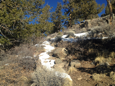
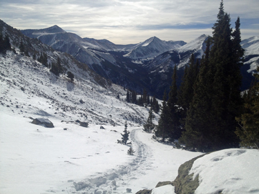
 We found the trailhead as advertised in the report of yet another, the "no camping" sign providing confirmation of our location. The Xterra offered warmth while the snow covered road leading off into the trees offered us little more than the promise of cold and that wonderful tired feeling that comes at the end of ten or twelve hours expended in gaining a summit in the midst of winter. We hefted the packs, lashed the snowshoes on just in case, and were on our way. The trail started as an old road with but a few inches of snow and led up along the course of Grouse Creek for a quarter mile or so. We knew that we had to cut off to the right at some point and kept our eyes peeled for a cairn or other sign. We found the trailhead as advertised in the report of yet another, the "no camping" sign providing confirmation of our location. The Xterra offered warmth while the snow covered road leading off into the trees offered us little more than the promise of cold and that wonderful tired feeling that comes at the end of ten or twelve hours expended in gaining a summit in the midst of winter. We hefted the packs, lashed the snowshoes on just in case, and were on our way. The trail started as an old road with but a few inches of snow and led up along the course of Grouse Creek for a quarter mile or so. We knew that we had to cut off to the right at some point and kept our eyes peeled for a cairn or other sign.
 What we found before we found the right route was a wonderfully alluring sucker trap leading up and the the . . . left. It looked so good, it climbed and it had traffic. I know from my caving days the lure of a good sucker trap, that piece of gotta go passage that just calls to the cave explorer and then with a note of finality leaves one looking at a blank wall. We surmounted a slick set of rocks and after gaining 75 feet or so, we found that that the traffic was just slough . . . a classic sucker trap and we were had. What we found before we found the right route was a wonderfully alluring sucker trap leading up and the the . . . left. It looked so good, it climbed and it had traffic. I know from my caving days the lure of a good sucker trap, that piece of gotta go passage that just calls to the cave explorer and then with a note of finality leaves one looking at a blank wall. We surmounted a slick set of rocks and after gaining 75 feet or so, we found that that the traffic was just slough . . . a classic sucker trap and we were had.
The trap however had a silver lining, it was the perfect vantage point to see the obvious traffic pattern calling out from the other bank. We descended and picked up a solid traffic pattern and headed on upward. The snow petered out so we connected trail segments, real trail here and there but more likely than not the scuff marks left by a hiking boot on a gravelly surface, easy to see and follow after a couple hundred climbs but not so obvious to the less experienced climber. We continued up and then . . . there was a cairn, swhich we knew they were out there but we also knew that they were the sentinels of a tough to follow path in the summer, not to mention the winter.
 We hit snow again and followed the tracks of the prior group to the vicinity of a large snag, after which I chased one too many cairns, or the promise thereof, and lost their course and started making my own. I knew the other crew had gone high so after going a couple hundred yards, we came upon a shallow gully that offered a route upward in a hurry. I took the chance and when we topped out on the next flat, there was a snowshoe trench, clear as day, now joined by our lonely tracks coming up slope from the woods below. Now we had a route and enough snow that we were not going get off course between here and when we chose to part company for Pt. 13,626 in lieu of Mt. Princeton's southwest ridge. We hit snow again and followed the tracks of the prior group to the vicinity of a large snag, after which I chased one too many cairns, or the promise thereof, and lost their course and started making my own. I knew the other crew had gone high so after going a couple hundred yards, we came upon a shallow gully that offered a route upward in a hurry. I took the chance and when we topped out on the next flat, there was a snowshoe trench, clear as day, now joined by our lonely tracks coming up slope from the woods below. Now we had a route and enough snow that we were not going get off course between here and when we chose to part company for Pt. 13,626 in lieu of Mt. Princeton's southwest ridge.
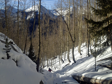
 We found ourselves below the treed portion of the SW ridge and moving up drainage until we hit a tributary drainage that I knew from prior narratives would take us to tree line. The tracks cut up hill, and I mean hard up hill, and we followed. Soon enough we arrived at another way point, a stream gully that I recognized and which gave us our final leg to tree line, or what we thought was tree line. I'm being facetious in my description but I would swear that we climbed to well over 15,000 feet before we finally got high enough to escape the damned trees in this drainage. The trees never seemed to give way and even after we broke loose from the majority of them, the route just took us up and round a curve to more damned trees. We found ourselves below the treed portion of the SW ridge and moving up drainage until we hit a tributary drainage that I knew from prior narratives would take us to tree line. The tracks cut up hill, and I mean hard up hill, and we followed. Soon enough we arrived at another way point, a stream gully that I recognized and which gave us our final leg to tree line, or what we thought was tree line. I'm being facetious in my description but I would swear that we climbed to well over 15,000 feet before we finally got high enough to escape the damned trees in this drainage. The trees never seemed to give way and even after we broke loose from the majority of them, the route just took us up and round a curve to more damned trees.
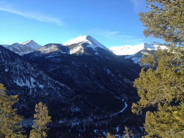
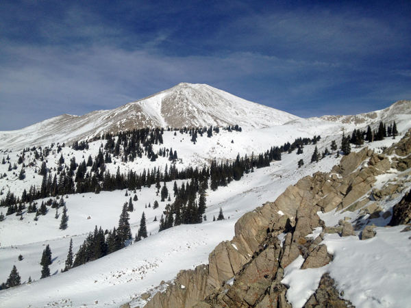
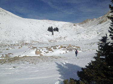 We continued on the strong trial until it cut up to Princeton's SW Ridge and we broke the crest of the ridge to see where Pt. 13,626 lay up the valley. We found our point but realized that we were already too high by a hundred feet and we would have to loose some elevation to continue. I was told by a friend that once you climb the 14'ers and elect to climb the Centennials, there is the reward of new valleys, unseen by the 14'er bagging crowd. We were now in such a place and it turned out to be a cruel place in the winter. I looked down to see that the route to our summit would cause us to cross what look like lateral moraines coming down from the Princeton ridge. We continued on the strong trial until it cut up to Princeton's SW Ridge and we broke the crest of the ridge to see where Pt. 13,626 lay up the valley. We found our point but realized that we were already too high by a hundred feet and we would have to loose some elevation to continue. I was told by a friend that once you climb the 14'ers and elect to climb the Centennials, there is the reward of new valleys, unseen by the 14'er bagging crowd. We were now in such a place and it turned out to be a cruel place in the winter. I looked down to see that the route to our summit would cause us to cross what look like lateral moraines coming down from the Princeton ridge.
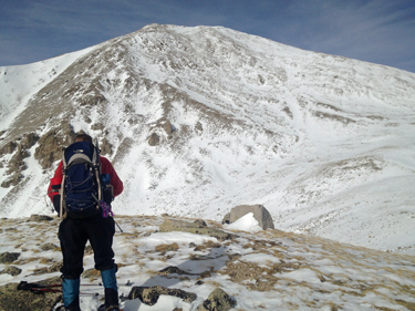 These features would cause us to lose 100 feet and then gain the 100 feet back in order to go on to the next similar feature. In the summer these are not a problem, but now we are looking at bare slopes, holding 18 to 24 inches of powdered sugar snow and the opportunity to get buried in a slough. We had to gain the ridges but also use extra effort and distance to pick the right line and avoid the open slopes. Finally, we crossed the last one and found ourselves standing atop a knoll that gave us a view of the final ascent to the summit of Pt. 13,626. We would, of course, have to go down to get up but we chose to make a somewhat straightish line to the far ridge in order to not loose too much elevation. These features would cause us to lose 100 feet and then gain the 100 feet back in order to go on to the next similar feature. In the summer these are not a problem, but now we are looking at bare slopes, holding 18 to 24 inches of powdered sugar snow and the opportunity to get buried in a slough. We had to gain the ridges but also use extra effort and distance to pick the right line and avoid the open slopes. Finally, we crossed the last one and found ourselves standing atop a knoll that gave us a view of the final ascent to the summit of Pt. 13,626. We would, of course, have to go down to get up but we chose to make a somewhat straightish line to the far ridge in order to not loose too much elevation.
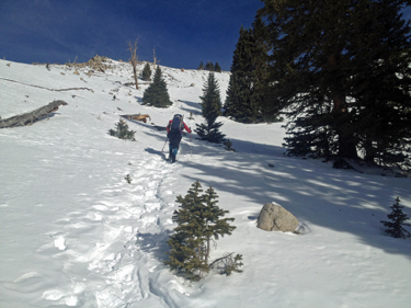
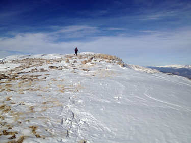
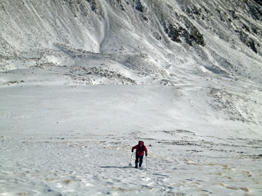 We connected high points before finally veering left to make the ridge line proper from which it was easy, just climb up. My legs were screaming as we'd resorted to using the snowshoes from the top of the gully just below tree line to this point and would do so to the summit. The elevation gain turned out to be the better part of 1100 feet from the knoll and not until we knocked that down to 400 feet did I get my summit mojo, which made the rest of the climb a less painful experience. We summitted at 2:10 or so, having been moving steadily for 7 hours. I thought it would be faster ascent but it was winter and nothing comes easy in the way of summits when the effort occurs at the start of January. We connected high points before finally veering left to make the ridge line proper from which it was easy, just climb up. My legs were screaming as we'd resorted to using the snowshoes from the top of the gully just below tree line to this point and would do so to the summit. The elevation gain turned out to be the better part of 1100 feet from the knoll and not until we knocked that down to 400 feet did I get my summit mojo, which made the rest of the climb a less painful experience. We summitted at 2:10 or so, having been moving steadily for 7 hours. I thought it would be faster ascent but it was winter and nothing comes easy in the way of summits when the effort occurs at the start of January.
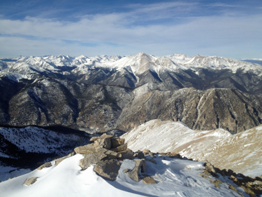
 We remained on the summit long enough to get a bite, a sip and leave the requisite gummy bear for Pachamama, in prayer for no wind in our faces and no orthopedic upsets between the summit and the truck. We followed our ascent route down, figuring that our tracks and later those of the other group would provide a solid enough route to allow easy transit to the trailhead in the dark. My descents usually take 2/3 of the time required to climb up, so I was figuring that at least the last third of the wooded portion of the drop would be in the dark. We moved steadily down and traversed over the spines to reunite with the track of the other party which was well beaten and beaten again . . . we had a highway. We made good time through the woods and by 4:30 were looking at the valley bottom and connecting a cairn here and there with the solid trail, even as it broke out into the partly melted slope above the road. We remained on the summit long enough to get a bite, a sip and leave the requisite gummy bear for Pachamama, in prayer for no wind in our faces and no orthopedic upsets between the summit and the truck. We followed our ascent route down, figuring that our tracks and later those of the other group would provide a solid enough route to allow easy transit to the trailhead in the dark. My descents usually take 2/3 of the time required to climb up, so I was figuring that at least the last third of the wooded portion of the drop would be in the dark. We moved steadily down and traversed over the spines to reunite with the track of the other party which was well beaten and beaten again . . . we had a highway. We made good time through the woods and by 4:30 were looking at the valley bottom and connecting a cairn here and there with the solid trail, even as it broke out into the partly melted slope above the road.
 Our total time was just about an even ten hours as we made a very quick movement back from the summit. The prior group's snowshoe track likely gave us the summit, no reservations as to that admission, which comes with thanks and more than a modicum of respect for their route finding a week earlier. We found snowshoes to be the easiest way to travel once we broke tree line and ended up using them all the way to the summit and all the way back as far as the top of the final slope down to Grouse Creek. Overall, a great but tiring climb, somewhat due to the distance, the need for flotation, and that wee bit of winter weight we all seem to add around the Holidays. Our total time was just about an even ten hours as we made a very quick movement back from the summit. The prior group's snowshoe track likely gave us the summit, no reservations as to that admission, which comes with thanks and more than a modicum of respect for their route finding a week earlier. We found snowshoes to be the easiest way to travel once we broke tree line and ended up using them all the way to the summit and all the way back as far as the top of the final slope down to Grouse Creek. Overall, a great but tiring climb, somewhat due to the distance, the need for flotation, and that wee bit of winter weight we all seem to add around the Holidays.
|
