West Spanish Peak
July 8, 2012 - Cordova Pass - West Spanish Peak Trail
The weekend goal was to pick off Phoenix Peak on my way toward my goal of completing the Centennials but a cat with a swollen head and the arrival of the monsoon (a true blessing this year due to fires) made for a change of plans. My wife and I planned to leave Cheyenne at noon but upon arriving home, I was presented with a head bitten cat, the obvious result of a recent fight. I'm an old hand with cats so I played the role of Sgt. Strongarm and my wife the part of Nurse Peroxide. We left a cleaned up but very pissed off cat at home and were finally on our way at around 2 p.m.
The net effect of the delay is that we would arrive in Creede at dark if we stopped for dinner. Not stopping for dinner was out of the question and we were further slowed by torrential rains at multiple points along the way. We finally ended up in Creede, in the dark, and in the rain at 9:30, looking for a commando spot that would let me access the trailhead from the tart the next morning. We ended up driving a circuit of the Willow Creek loop and then leaving Creede in a state of general piss off as the rain fell and fell and fell. We headed back toward Del Norte and found a spot at the U.S.F.S. Palisades Campground about 10 miles east of town. The spot we chose was in the trees and for a moment, the rain let up to a light drizzle and we bailed into setting up the tent, pumping up the air mattress and getting set for the night. I don't think either of us had set up camp in the rain in a number of yers and to her credit my wife bailed in just like we did years ago.
 We were wet but inside the tent was dry and we both got a great night's sleep lulled by the pitter patter of rain for most of the night. I never even bothered to set the alarm. We broke camp the next morning by about 8:30 and went back to Creede to scope out the Willow Creek TH for another trip. I hiked a bit of the 4WD road to get a feel for how it would treat a stock Tacoma and concluded I would be walking the road the next time I took a shot at Phoenix. We cooked breakfast along side of the road, old school for sure, and then walked around Creede before heading east to Del Norte and Monte Vista. We hit Monte Vista a bit after noon and did the picnic lunch in the park, before taking an informal walking tour of the town. We were wet but inside the tent was dry and we both got a great night's sleep lulled by the pitter patter of rain for most of the night. I never even bothered to set the alarm. We broke camp the next morning by about 8:30 and went back to Creede to scope out the Willow Creek TH for another trip. I hiked a bit of the 4WD road to get a feel for how it would treat a stock Tacoma and concluded I would be walking the road the next time I took a shot at Phoenix. We cooked breakfast along side of the road, old school for sure, and then walked around Creede before heading east to Del Norte and Monte Vista. We hit Monte Vista a bit after noon and did the picnic lunch in the park, before taking an informal walking tour of the town.
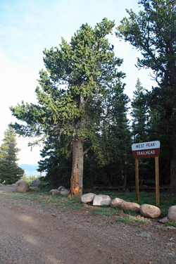 My plan to climb Phoenix did not include a Sunday alternative due to the driving distance back to Cheyenne, we just did not want to get back at midnight. I figured instead to head for La Veta and camp just below the Spanish Peaks. I figured I could pull off a climb of bicentennial West Spanish Peak the next morning and then we could head for home, salvaging the weekend with a day of tourism and a morning of climbing. We scored a great camp site at the Blue Lake Campground off CO 12 and were set for the night. The next morning we were up by 5:45 and broke camp to make the drive to Cordova Pass/West Peak Trailhead and the start of the climb. We repeated the old school breakfast scene at Cordova Pass, once again setting the stove up on the tailgate and having bacon and cup-o-noodles. My plan to climb Phoenix did not include a Sunday alternative due to the driving distance back to Cheyenne, we just did not want to get back at midnight. I figured instead to head for La Veta and camp just below the Spanish Peaks. I figured I could pull off a climb of bicentennial West Spanish Peak the next morning and then we could head for home, salvaging the weekend with a day of tourism and a morning of climbing. We scored a great camp site at the Blue Lake Campground off CO 12 and were set for the night. The next morning we were up by 5:45 and broke camp to make the drive to Cordova Pass/West Peak Trailhead and the start of the climb. We repeated the old school breakfast scene at Cordova Pass, once again setting the stove up on the tailgate and having bacon and cup-o-noodles.
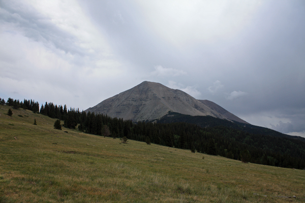
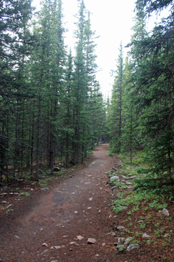 With breakfast done and the clock reading 7:30, I hefted my pack and was on my way toward West Spanish Peak. The reports I had read indicated that the first part of the trail would be a flattish, well groomed, hike to the base of the ridge, after which the climb to the summit would come in one sustained ridge ascent of 1800+ feet in less than a mile. The trail was as advertised, a hike through the woods to a large clearing that gave a great view of the peak. The trail did in fact roll up and down as it slowly gained elevation en route to the ridge. After crossing the open field, the trail remained in the woods until coming to a junction with the Arishapa trail, marking the start of a series of gentle switchbacks leading toward tree line. The trail was well signed and well traveled, leaving no room for loss of route or doubt as to destination. With breakfast done and the clock reading 7:30, I hefted my pack and was on my way toward West Spanish Peak. The reports I had read indicated that the first part of the trail would be a flattish, well groomed, hike to the base of the ridge, after which the climb to the summit would come in one sustained ridge ascent of 1800+ feet in less than a mile. The trail was as advertised, a hike through the woods to a large clearing that gave a great view of the peak. The trail did in fact roll up and down as it slowly gained elevation en route to the ridge. After crossing the open field, the trail remained in the woods until coming to a junction with the Arishapa trail, marking the start of a series of gentle switchbacks leading toward tree line. The trail was well signed and well traveled, leaving no room for loss of route or doubt as to destination.
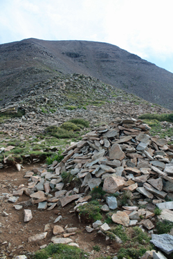 The route broke tree line after about 1/2 mile and there lay the ridge that would lead to the summit. The route upward is marked by a large cairn, about 4 feet high and then a few smaller piles here and there as the trail starts its upward climb. The trail comes and goes but after about 100 yards, it gains strength, leading little doubt as to route. The path winds here and there but generally makes a beeline for the heights, while clinging to the southern side of the ridge most of the way. The route did braid a bit here and there but at every point where the route was not simply obvious, a moment of hesitation allowed me to re-identify the traffic pattern and move further upward. The route broke tree line after about 1/2 mile and there lay the ridge that would lead to the summit. The route upward is marked by a large cairn, about 4 feet high and then a few smaller piles here and there as the trail starts its upward climb. The trail comes and goes but after about 100 yards, it gains strength, leading little doubt as to route. The path winds here and there but generally makes a beeline for the heights, while clinging to the southern side of the ridge most of the way. The route did braid a bit here and there but at every point where the route was not simply obvious, a moment of hesitation allowed me to re-identify the traffic pattern and move further upward.
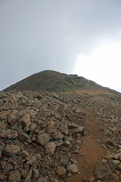 The trail jogged and jumped as small ledges presented themselves before I broke the ridge proper and the trail continued its serpentine course upward. I expected that the skyline was the summit but as I broke the high point, I spotted the true summit off in the distance about one quarter mile from my ridge break point. At this point, the weather was starting to deteriorate but I was still early and there was time to traverse the short ridge to tag the summit proper. The clouds were not yet a threat but that possibility remained an option for later in the day, without a doubt. I tagged the true summit and took the required summit shot and an additional few moments to do a bit of clean up. It seems that there is no summit register on this peak and that over the past month about a dozen climbers had chosen to vandalize the highpoint by marking their names on rocks and placing them on the summit cairn for all to see. Sorry assholes, I chucked all your rocks over the crest, erasing your efforts to leave more than footprints. The trail jogged and jumped as small ledges presented themselves before I broke the ridge proper and the trail continued its serpentine course upward. I expected that the skyline was the summit but as I broke the high point, I spotted the true summit off in the distance about one quarter mile from my ridge break point. At this point, the weather was starting to deteriorate but I was still early and there was time to traverse the short ridge to tag the summit proper. The clouds were not yet a threat but that possibility remained an option for later in the day, without a doubt. I tagged the true summit and took the required summit shot and an additional few moments to do a bit of clean up. It seems that there is no summit register on this peak and that over the past month about a dozen climbers had chosen to vandalize the highpoint by marking their names on rocks and placing them on the summit cairn for all to see. Sorry assholes, I chucked all your rocks over the crest, erasing your efforts to leave more than footprints.
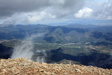 I reversed course for the truck, and descended the ridge making much better time on the descent, passing three people working to ascend to the summit now shadowed by darkening clouds. My arrival back at tree line was marked with the first roll of thunder and as I walked the mile and a half of easy terrain to the trailhead, there were another two or three obvious indications that the old adage of being off the summit by noon, or in this case 11:30 would be a really good idea during the monsoon season. I was back at the truck at noon and by 2:00 we were in Walsenburg looking back at one of the darkest walls thunderstorms that I've ever seen, and no sign of the Spanish Peaks within. I reversed course for the truck, and descended the ridge making much better time on the descent, passing three people working to ascend to the summit now shadowed by darkening clouds. My arrival back at tree line was marked with the first roll of thunder and as I walked the mile and a half of easy terrain to the trailhead, there were another two or three obvious indications that the old adage of being off the summit by noon, or in this case 11:30 would be a really good idea during the monsoon season. I was back at the truck at noon and by 2:00 we were in Walsenburg looking back at one of the darkest walls thunderstorms that I've ever seen, and no sign of the Spanish Peaks within.
|
