Dyer Peak (winter climb & ski)
January 10, 2009 - from Iowa Gulch winter closure
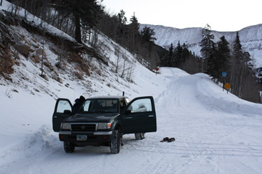
G celebrated the start of the 2009 by having his right ACL reconstructed and, though invited on this climb 5 days post-op, he "opted" not to join us. Bob and I left Cheyenne on Friday afternoon and headed to Leadville for a night at the Super 8 and dinner in Leadville. We fought our way through the ski traffic and made it to Leadville at 8 pm. We were at the Super 8 by 9:30 and agreed that an alpine start was not needed as the climb of Dyer Peak would only be about 9 miles round trip and a bit over 3000 feet of elevation gain. I figured if we hit the trail head at 7 am we would be in good shape for closing the day out by 4 pm. Just in time to fight the predictable ski traffic back to Denver.
 It was -6F when we left the motel and I assure you it had not warmed up by much by the time we got to the trail head. We killed a little bit of time to let dawn arrive and I started the climb off with what was to be a sign of things to come, a good trail head morning constitutional of dubious slump characteristics. I halked it up to a heavy dinner . . . I'm used to lighter fare . . . surely nothing to worry about, just one of those minor system upsets. We hefted the packs and set off up the road toward Iowa Gulch, a 3 mile trek to the base of the my planned route up the eastern flank of Dyer Peak. I led and for the first mile, we snowshoed along a well trod path made by other snowshoers and a skier or two. After a mile, the ski tracks cut off to a side drainage and the snowshoers seemed to have lost interest at about the second mile. It was -6F when we left the motel and I assure you it had not warmed up by much by the time we got to the trail head. We killed a little bit of time to let dawn arrive and I started the climb off with what was to be a sign of things to come, a good trail head morning constitutional of dubious slump characteristics. I halked it up to a heavy dinner . . . I'm used to lighter fare . . . surely nothing to worry about, just one of those minor system upsets. We hefted the packs and set off up the road toward Iowa Gulch, a 3 mile trek to the base of the my planned route up the eastern flank of Dyer Peak. I led and for the first mile, we snowshoed along a well trod path made by other snowshoers and a skier or two. After a mile, the ski tracks cut off to a side drainage and the snowshoers seemed to have lost interest at about the second mile.
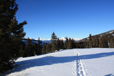
 I was now breaking trail but with an eye toward the drift pattern of the snow, I could still pick up signs of previous travelers and stay on a compacted course for most of the way to the part of the road that, in all my prior trips up to Iowa gulch in the spring and winter, is blown free of snow. I don't think I really had to break trail through more than 100 yards of loose snow, but where it was loose, the shoes sank a full foot before hitting a layer that would support us. We made the blown free section of road and the wind, that had been absent to this point, now came on, gusting here and there. Not a hard wind but enough to slide down through the side drainages, bringing with it a skiff of snow here and there in the form of a snow devil or a plume from the looming summit ridge of Mount Sherman. I was now breaking trail but with an eye toward the drift pattern of the snow, I could still pick up signs of previous travelers and stay on a compacted course for most of the way to the part of the road that, in all my prior trips up to Iowa gulch in the spring and winter, is blown free of snow. I don't think I really had to break trail through more than 100 yards of loose snow, but where it was loose, the shoes sank a full foot before hitting a layer that would support us. We made the blown free section of road and the wind, that had been absent to this point, now came on, gusting here and there. Not a hard wind but enough to slide down through the side drainages, bringing with it a skiff of snow here and there in the form of a snow devil or a plume from the looming summit ridge of Mount Sherman.
 We tracked along the shelf road as the path cut along the southernmost flank of Dyer Peak and stuck with the road almost to the summer trail head parking. However, instead of going to the head of the gulch and then choosing between Dyer and Gemini, I elected to again cut up the eastern flank of Dyer, picking a rounded rock strewn course between a well loaded avalanche path to the south and a jagged gully a bit to the north. I'd been up this route before, when G, Reach, and I skied Dyer about three winters before. Before we started; however, Bob took the opportunity to imitate my start of climb cleansing session. Is there a Bolivian pattern here? . . . With Bob's need taken care of, we started up the slope, toward what I recalled to be a ridge line traverse to the unseen summit. We tracked along the shelf road as the path cut along the southernmost flank of Dyer Peak and stuck with the road almost to the summer trail head parking. However, instead of going to the head of the gulch and then choosing between Dyer and Gemini, I elected to again cut up the eastern flank of Dyer, picking a rounded rock strewn course between a well loaded avalanche path to the south and a jagged gully a bit to the north. I'd been up this route before, when G, Reach, and I skied Dyer about three winters before. Before we started; however, Bob took the opportunity to imitate my start of climb cleansing session. Is there a Bolivian pattern here? . . . With Bob's need taken care of, we started up the slope, toward what I recalled to be a ridge line traverse to the unseen summit.
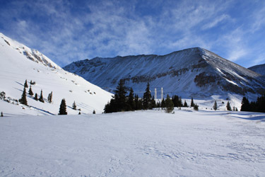
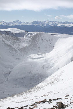 Bob started lagging behind and by the time were half way up the slope I knew there was a problem. He'd made another impromptu stop and from my wealth of climbing experience, I realized he was doing the "bonk." Nothing like a bug in the bowel to make a climb interesting, and within one half hour, I was sure that whatever he had eaten was also present in my dinner. So there we are at 13,450, Bob cramped up in the legs due to dehydration and in the bowel due to gosh knows what we ate . . . and now I have joined his club with a less than 10 second warning that I have another membership payment due immediately. This climb had gone to hell real quick, and all of about 1/2 mile from the summit. In addition to bad bowels, the beautiful and warming sun filled sky was being swept away by a dark gray scud of cloud, now obscuring the Sawatch as well as neighboring Mosquito 14'er and high 13'er summits. Bob started lagging behind and by the time were half way up the slope I knew there was a problem. He'd made another impromptu stop and from my wealth of climbing experience, I realized he was doing the "bonk." Nothing like a bug in the bowel to make a climb interesting, and within one half hour, I was sure that whatever he had eaten was also present in my dinner. So there we are at 13,450, Bob cramped up in the legs due to dehydration and in the bowel due to gosh knows what we ate . . . and now I have joined his club with a less than 10 second warning that I have another membership payment due immediately. This climb had gone to hell real quick, and all of about 1/2 mile from the summit. In addition to bad bowels, the beautiful and warming sun filled sky was being swept away by a dark gray scud of cloud, now obscuring the Sawatch as well as neighboring Mosquito 14'er and high 13'er summits.
I know from our prior climb that the summit was still about 1/2 mile off and would have been reached by crossing to the ridge proper and then traversing to the summit cone. G, Reach, and I had summited Dyer earlier but a repeat of that experience was not 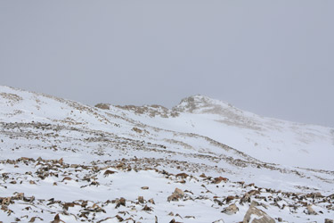 be so on this now gray and dismal early afternoon. I passed my water to Bob along with another Goo, and after a few minutes, we headed back down to the road about 200 feet below our turn point. The trip out was a long trek as this is about the only section of downhill road that I know that actually is longer on the way out than it is on the way in. Seems that way every time . . . be so on this now gray and dismal early afternoon. I passed my water to Bob along with another Goo, and after a few minutes, we headed back down to the road about 200 feet below our turn point. The trip out was a long trek as this is about the only section of downhill road that I know that actually is longer on the way out than it is on the way in. Seems that way every time . . .
We made the truck at a bit after 3:30 and made the next stop in Leadville, the Safeway restroom to be exact, for another reminder to select an alternate eating establishment for our next trip. We made a similar all hands stop at the Georgetown visitor center and a damn fast final approach to my driveway to wrap up this 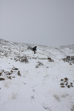 Bolivia style trip. But I will note that having been sick in Bolivia for ten days straight, this was mild in comparison, but still this is certainly no way to conduct a winter climb . . . Bolivia style trip. But I will note that having been sick in Bolivia for ten days straight, this was mild in comparison, but still this is certainly no way to conduct a winter climb . . .
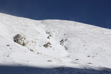
For those interested in skiing this peak, on our previous trip we skinned in all the way to the summer trail head and then carried the skis up the described route to the ridge line. We left the skis at the creat of the ridge line snow field and hiked to the summit, probably a mile further on. Summit in hand, we retreated back along the ridge and skied the large snowfield that in the right circumstances has "Watch Out!" written all over it. From there, we skied the road on back to the truck, three miles distant. The road out is not very steep and much of the ski is spent poling or kicking here and there to make forward progress, hence the road does not provide a carefree three mile glide to the trail head. But, skiing did seem better than hoofing it as I recall.
|
