Mt. Sneffels
Southwest Ridge - August 22, 2011 & June 17, 2012
August 22, 2011 . . .
Ed and I came to within one hundred feet of the summit of Sneffels in May but were defeated by snow conditions as we tried to exit the upper gully of the Lavender Col route. It is easy to tick off the peak when one gets that close but Ed had it in his mind that he had not quite scored the summit. It was not our only "darn close but turned around with reach of the top" as we'd been driven off of Mt. Lindsey by a very small but very electrically charged cloud just 50 yards from the summit. With the "Wilsons" in hand already on this trip, we figured to take care of those last few yards with an early morning Sneffels climb before heading back to the front range.
 We'd camped the night before at the second USFS campground, located just a bit below our start point for the May trip. As we drove up the shelf road and the 4 WD track, I watched the miles tick over on the odometer and was impressed with the distance we covered just a few months before on snowshoes. This time we were treading along in the trusty 200k+ mile Toyota, figuring to get started from the upper trail head. We left camp at a bit after 3 a.m. and were up to the trail head and walking by 4. We'd met a fellow the prior afternoon at the new Silverpick trail head and he suggested that we consider the Southwest Ridge route as an alternative to the Lavender Col. We'd both been up the regular route in the snow and I remembered doing it back in about 2000 when it was a scree slog that did not stick out as something one would want to repeat if not required to do so. We'd camped the night before at the second USFS campground, located just a bit below our start point for the May trip. As we drove up the shelf road and the 4 WD track, I watched the miles tick over on the odometer and was impressed with the distance we covered just a few months before on snowshoes. This time we were treading along in the trusty 200k+ mile Toyota, figuring to get started from the upper trail head. We left camp at a bit after 3 a.m. and were up to the trail head and walking by 4. We'd met a fellow the prior afternoon at the new Silverpick trail head and he suggested that we consider the Southwest Ridge route as an alternative to the Lavender Col. We'd both been up the regular route in the snow and I remembered doing it back in about 2000 when it was a scree slog that did not stick out as something one would want to repeat if not required to do so.
 We hiked up the road headed for the Blue Lakes Pass, knowing that the start of the SW Ridge would be the pass proper. There was a bit of a chill in the air this morning, as compared to the warmth that we'd had the last two mornings for early starts in the Wilsons. It wasn't a Fall chill by any means but there was a touch of a breeze and I had gloves on, We hiked up the road headed for the Blue Lakes Pass, knowing that the start of the SW Ridge would be the pass proper. There was a bit of a chill in the air this morning, as compared to the warmth that we'd had the last two mornings for early starts in the Wilsons. It wasn't a Fall chill by any means but there was a touch of a breeze and I had gloves on, 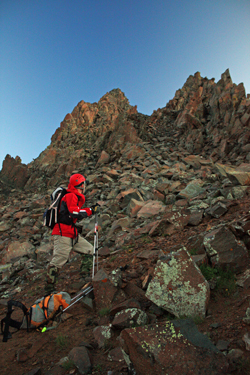 actually my mitten shells, but not because of the temperature. You see, it had rained the night before and I'd left my hiking poles out . . . the result was wet foam grips and that just did not seem like fun. Not being a Cottoneer, I actually took a fair amount of my cold weather gear along on this trip, so the outer mitten shells over my liners was just what I needed. actually my mitten shells, but not because of the temperature. You see, it had rained the night before and I'd left my hiking poles out . . . the result was wet foam grips and that just did not seem like fun. Not being a Cottoneer, I actually took a fair amount of my cold weather gear along on this trip, so the outer mitten shells over my liners was just what I needed.
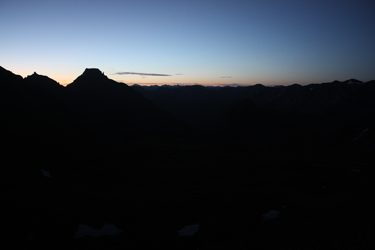
The distance to Blue Lakes Pass is about 2 miles and we figured that if we made a steady pace, we could arrive right when there was enough light to turn right and climb the 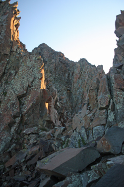 ridge. I think we might have stopped for a Gu once along the way but otherwise we made steady progress as the sky began to show some signs of dawn the the east. The trail started as road, then went to single track and then before the pass proper, took a couple of major zigs back and forth, switching back to cross the saddle. We arrived about 15 minutes before there was enough light to climb the ridge, so we both took the opportunity to lighten our loads as the sun made steady progress. ridge. I think we might have stopped for a Gu once along the way but otherwise we made steady progress as the sky began to show some signs of dawn the the east. The trail started as road, then went to single track and then before the pass proper, took a couple of major zigs back and forth, switching back to cross the saddle. We arrived about 15 minutes before there was enough light to climb the ridge, so we both took the opportunity to lighten our loads as the sun made steady progress.
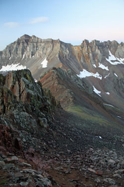
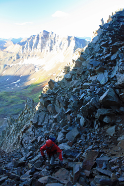 As Potosi Peak took on a bit of a glow, we started up the SW Ridge on a well defined trail. The course tracked the base of the western side of the ridge for about 300 feet of vertical before we really had to address any more technical ground. The trail led us to a gully that was marked by a cairn or two but was clearly the route that took the uphill traffic. The gully presented solid class 3 climbing for perhaps 150 to 200 feet of vertical before bringing us to the head of a large couloir that drops to the east. I'd read of this point in the guidebook and knew that we were to cross the top of the slot and then continue upward through class 4 terrain. We took a look to the left and that was not the way so into the slot we dropped, descending the noted 30 feet. The traffic sign remained strong as we climbed a short pitch instead of dropping further. As Potosi Peak took on a bit of a glow, we started up the SW Ridge on a well defined trail. The course tracked the base of the western side of the ridge for about 300 feet of vertical before we really had to address any more technical ground. The trail led us to a gully that was marked by a cairn or two but was clearly the route that took the uphill traffic. The gully presented solid class 3 climbing for perhaps 150 to 200 feet of vertical before bringing us to the head of a large couloir that drops to the east. I'd read of this point in the guidebook and knew that we were to cross the top of the slot and then continue upward through class 4 terrain. We took a look to the left and that was not the way so into the slot we dropped, descending the noted 30 feet. The traffic sign remained strong as we climbed a short pitch instead of dropping further.
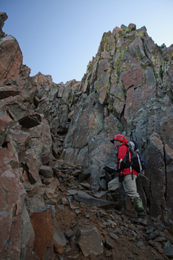 The pitch, marked by a small cairn, led us to the upward continuation of the slot, which we crossed into after a hugging move around a rock or two that we ended up on the back side of by means of the previous short upward move. The rains from the night before made for mud under foot as we crossed over the upper extension of the slot and took to the class 4 climbing that would lead to the ridge proper. We gained perhaps another hundred feet of vertical via exposed climbing before the slope lessened and we were on the more mild ridge crest The pitch, marked by a small cairn, led us to the upward continuation of the slot, which we crossed into after a hugging move around a rock or two that we ended up on the back side of by means of the previous short upward move. The rains from the night before made for mud under foot as we crossed over the upper extension of the slot and took to the class 4 climbing that would lead to the ridge proper. We gained perhaps another hundred feet of vertical via exposed climbing before the slope lessened and we were on the more mild ridge crest 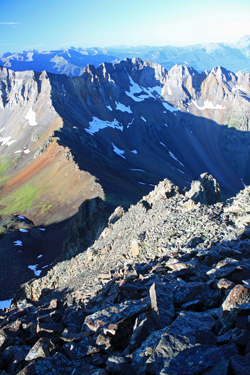 proper. The ridge continued on, granting gentle class 2 terrain with no route finding issues. However as we neared the top, I think we strayed a bit further on ridge proper than the others before us did and found ourselves on a series of grippy granite forming the rounded ridge crest. I suspect that if we had we stayed a bit lower we would have avoided this more exposed terrain and had the use of trail segments on the face below ridge proper. proper. The ridge continued on, granting gentle class 2 terrain with no route finding issues. However as we neared the top, I think we strayed a bit further on ridge proper than the others before us did and found ourselves on a series of grippy granite forming the rounded ridge crest. I suspect that if we had we stayed a bit lower we would have avoided this more exposed terrain and had the use of trail segments on the face below ridge proper.
We worked our way up the now sun dried ridge for another five minutes or so before coming to the major herd paths that come up from the top of the Lavender Col. Clearly some climb the Col and then strike out onto the face, some do the slot above the Col . . . regardless there was no shortage of well 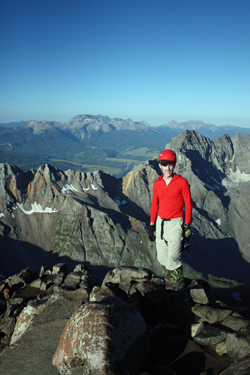 used trail segments to choose from as we climbed to the summit proper. Ed was soon standing atop Mt. Sneffels . . . nobody would be able to claim that he had anything less than a full summit. We'd made the climb in 4 hours, a bit longer than we thought it would take. The mud along the ridge cost us a bit of time as that portion of the route did offer a bit of exposure and we took our time. We took photos from the summit but after no more than ten minutes, we were on our way down. used trail segments to choose from as we climbed to the summit proper. Ed was soon standing atop Mt. Sneffels . . . nobody would be able to claim that he had anything less than a full summit. We'd made the climb in 4 hours, a bit longer than we thought it would take. The mud along the ridge cost us a bit of time as that portion of the route did offer a bit of exposure and we took our time. We took photos from the summit but after no more than ten minutes, we were on our way down.
We were going to descend the Lavender Col route so we connected the ledges that are clearly the route for the vast majority of ascents. We elected to skip crossing over to the top of the chute above the Col but instead chose an entry ramp about half way down the length of the narrow gully. We crossed to the other side of the chute to pick up the climber's trail, figuring it was better to forgo the still wet rocks for a bit of a herd path where the bit stuff was long since 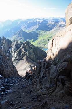 stabilized by thousands of feet before us. As we reached the top of the Col, we saw our first climber of the day, about 2/3 of the way up to the saddle at the top of the Col. We headed down, making sure not to knock anything loose, but making good time, hiking poles a flailin'. stabilized by thousands of feet before us. As we reached the top of the Col, we saw our first climber of the day, about 2/3 of the way up to the saddle at the top of the Col. We headed down, making sure not to knock anything loose, but making good time, hiking poles a flailin'.
We exchanged greetings with the other fellow and moved on, passing another 6 or 8 people in the lower reaches of the Col. The trail down through was as I remembered it, a severely braided set of tracks winding their way down through the screen and small talus that make up the Lavender Col. At the bottom, we came to a set of stone steps in the trail and a pair of five foot cairns that marked the start of the upward 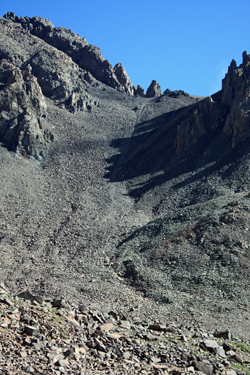 trek through the scree. Kind of a gate way . . . a asinine creation by some dimwitted Cottoneer seeking to bring order to the mountain. We passed another 6 Cottoneers on their way up by the time the re-aligned trail went somewhat flat and we came to a cut off that, with an investment of a quarter mile, took us back to the Blue Lakes Pass trail and its single dirt track. trek through the scree. Kind of a gate way . . . a asinine creation by some dimwitted Cottoneer seeking to bring order to the mountain. We passed another 6 Cottoneers on their way up by the time the re-aligned trail went somewhat flat and we came to a cut off that, with an investment of a quarter mile, took us back to the Blue Lakes Pass trail and its single dirt track.
Once on the dirt trail, we were away from the uphill traffic and easily covered the distance to the jeep trail that marked about the one half way point back to the truck. We were passed by a jeep or two and a few late starters oblivious of the darkening skies but soon enough we were back at the truck, sipping a cold iced tea and getting the gear stowed for the drive back to Denver and Cheyenne.
June 17, 2012 . . . repeat performance, different cast . . . 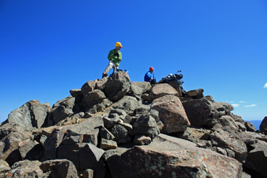
The day before Bob and I scored the summit of Dallas Peak but G and Calvin had not had the opportunity to summit, hence a 14'er repeat was in my cards, G got a repeat but by a different route and Bob and Calvin scored new 14'er via this fun route. Bob and Calvin led the way from start to finish and had no issues with route finding other than the one sucker trap that I think takes in most every climber along the way. We ended up with a six hour climb, good weather the whole time, and made sure everyone got a summit over this trip to the San Juans.
Mt. Sneffels' Lavender Col in the dry and in the snow . . .
|

