Drift Peak (winter climb & ski)
April 27, 2008 - from Mayflower Gulch
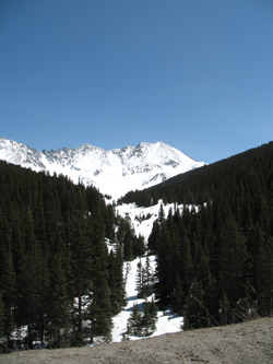
G and I had been bouncing around the idea of a return to Mayflower Gulch and a climb of one of the peaks ranging from Pacific on one end of the gulch to Drift on the other. We also somehow convinced Bob, G's work compadre, to come along as he had climbed 14'ers of the Collegiate range but not taken on anything similar in the winter months. We also baited him with the idea that we would ski the peak (or at least part of it), hence tugging at his desire to give back country skiing a try. With that loose plan in hand, we chose to take a shot at Fletcher peak, the 13,950 foot high center point of the jagged ridge that forms the terminal wall of Mayflower Gulch.
 We saw no reason to get up at 0 dark 30 and make a 3 plus hour drive to the trail head so long as Leadville offered the opportunity to overnight just 15 miles from the start of the climb and the more important promise of prime rib at Quincy's restaurant the night before the climb. We left Cheyenne at 3 p.m. and we stopped along the road looking up Mayflower Gulch just about three hours later. Lots of snow in the valley, that much was obvious and we walked perhaps 100 yards up the snow packed road to get a look at the climbing possibilities. G and I tried Atlantic in the winter of 2002 and remembered the deep snow and our progress up that long ridge to a spot near the top where we turned around. Pacific looked good but what really caught our eye was the centered highpoint of Fletcher. We saw no reason to get up at 0 dark 30 and make a 3 plus hour drive to the trail head so long as Leadville offered the opportunity to overnight just 15 miles from the start of the climb and the more important promise of prime rib at Quincy's restaurant the night before the climb. We left Cheyenne at 3 p.m. and we stopped along the road looking up Mayflower Gulch just about three hours later. Lots of snow in the valley, that much was obvious and we walked perhaps 100 yards up the snow packed road to get a look at the climbing possibilities. G and I tried Atlantic in the winter of 2002 and remembered the deep snow and our progress up that long ridge to a spot near the top where we turned around. Pacific looked good but what really caught our eye was the centered highpoint of Fletcher.
 If you are climbing in the Leadville area . . . I cannot over recommend getting dinner at Quincy's on Harrison Avenue, about midway through the town of Leadville. The menu is a bit different, you choose only the size of the prime rib or the filet, depending on the night you go there. My experience is that Friday and Saturday are prime nights and for the other nights of the week the choice is limited to the size of the filet you want. Add a baked potato and salad and you have enough protein and starch to get you up any 14'er in the area. I don't miss this place if I'm climbing nearby. Needless to say, we caught dinner before going to overnight at the Super 8 a mile beyond the second bend in the road. The room was oppressively hot but despite a parking lot full of corporate transportation, it was a quiet night, at least until we got up at 4 a.m. to head for the trail head. If you are climbing in the Leadville area . . . I cannot over recommend getting dinner at Quincy's on Harrison Avenue, about midway through the town of Leadville. The menu is a bit different, you choose only the size of the prime rib or the filet, depending on the night you go there. My experience is that Friday and Saturday are prime nights and for the other nights of the week the choice is limited to the size of the filet you want. Add a baked potato and salad and you have enough protein and starch to get you up any 14'er in the area. I don't miss this place if I'm climbing nearby. Needless to say, we caught dinner before going to overnight at the Super 8 a mile beyond the second bend in the road. The room was oppressively hot but despite a parking lot full of corporate transportation, it was a quiet night, at least until we got up at 4 a.m. to head for the trail head.
 The temperature on Sunday was supposed to approach 50 and we wanted to make sure that we did not run into wet slide conditions later in the day. The ridge we were looking to climb is named after the fellow killed on that ridge by an avalanche. I suspect that slide was a classic winter run but we saw no point in giving the ridge a hyphenated name to memorialize a late start on our part. We gathered our gear and made our way to the convenience store for some early am low end nourishment before arriving at the trail head at 5 am sharp. We looked at the thermometer and it had dropped to all of 6 degrees, hence we thought we might set tight just a bit until the sky started to lighten up. We did not wait long and all three of us bailed out to ready our gear. We set everything on the snow and piled back into the truck of a pre start pre-heat of our cores. The temperature on Sunday was supposed to approach 50 and we wanted to make sure that we did not run into wet slide conditions later in the day. The ridge we were looking to climb is named after the fellow killed on that ridge by an avalanche. I suspect that slide was a classic winter run but we saw no point in giving the ridge a hyphenated name to memorialize a late start on our part. We gathered our gear and made our way to the convenience store for some early am low end nourishment before arriving at the trail head at 5 am sharp. We looked at the thermometer and it had dropped to all of 6 degrees, hence we thought we might set tight just a bit until the sky started to lighten up. We did not wait long and all three of us bailed out to ready our gear. We set everything on the snow and piled back into the truck of a pre start pre-heat of our cores.
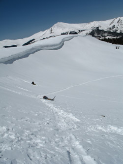
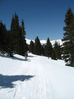
 We stepped into the skis and snowshoes at 6 am sharp and were moved out smartly to keep warm. The day was bright but we also knew that we would not see any real sun hit for another two hours due to the orientation of the gulch. The route starts as an old mining road that goes for about one and one half miles to the mine that lies at the head of the gulch. We skinned and walked along the road, me in the lead, until we got to the mine cabin where I cut off to the right and started to climb in a skirting course to the ridge line that forms the base of the west ridge up Drift Peak. G and I knew from prior trips that the ridge proper, even down low, would likely have a well developed cornice, which it did. But there was a gap and after skiing across the just plain perfect glade above the cabin, we stepped out of the the skis to kick a couple dozen steps to the crest of the broad lower ridge. We stepped into the skis and snowshoes at 6 am sharp and were moved out smartly to keep warm. The day was bright but we also knew that we would not see any real sun hit for another two hours due to the orientation of the gulch. The route starts as an old mining road that goes for about one and one half miles to the mine that lies at the head of the gulch. We skinned and walked along the road, me in the lead, until we got to the mine cabin where I cut off to the right and started to climb in a skirting course to the ridge line that forms the base of the west ridge up Drift Peak. G and I knew from prior trips that the ridge proper, even down low, would likely have a well developed cornice, which it did. But there was a gap and after skiing across the just plain perfect glade above the cabin, we stepped out of the the skis to kick a couple dozen steps to the crest of the broad lower ridge.
 It was time for a discussion of what we wanted to ski this day as we could carry the skis much higher and make a run from perhaps the 1/2 or even the 2/3 mark of the climb. The only problem with that plan was that lugging the skis higher would mean more tired legs after the summit bid and the ski routes from higher up looked steep and perhaps well loaded. The short slope we just climbed had a hard layer under the most recent snow, giving me pause to consider the outcome of a fall on a slope a bit beyond my ability. I chose discretion and left my skis at the base of the ridge. My compadres did the same and we set off for the summit, Bob now in hikers and G and I in our ski boots. It was time for a discussion of what we wanted to ski this day as we could carry the skis much higher and make a run from perhaps the 1/2 or even the 2/3 mark of the climb. The only problem with that plan was that lugging the skis higher would mean more tired legs after the summit bid and the ski routes from higher up looked steep and perhaps well loaded. The short slope we just climbed had a hard layer under the most recent snow, giving me pause to consider the outcome of a fall on a slope a bit beyond my ability. I chose discretion and left my skis at the base of the ridge. My compadres did the same and we set off for the summit, Bob now in hikers and G and I in our ski boots.
Our boots are made for AT gear and have much more flex than the standard down hill boot. But, they are still less than ideal for a climb calling for the better part of 2000 vertical feet of ascent. I was less than enthused but G and I were in the same boat and putting on the lighter leather hikers I had stashed in my pack seemed like an invite for frozen feet. In hind sight, we were best off in the ski boots as my feet were cold on and off for the whole of the climb.
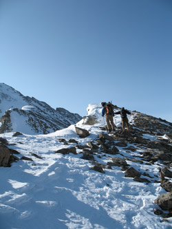
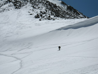
 I set off in the lead and we climbed the shortish steep section that forms the start of the ridge proper. The snow was firm and had a good frozen layer under the thin loose covering of recent snow. The hard layer took a good step but the step was, in many places, little for than a one inch ledge. While I have climbed for nearly a decade in plastic boots, with and without crampons, this was Bob's first experience with the slice kicked step and he found it took a bit of getting used to. I did my best, however, to kick solid toe holes wherever the snow would allow. Where the layer was really hard, I took a course a little closer to the rocks but not too close so as to avoid rotted out pockets filled with sugary facets. I set off in the lead and we climbed the shortish steep section that forms the start of the ridge proper. The snow was firm and had a good frozen layer under the thin loose covering of recent snow. The hard layer took a good step but the step was, in many places, little for than a one inch ledge. While I have climbed for nearly a decade in plastic boots, with and without crampons, this was Bob's first experience with the slice kicked step and he found it took a bit of getting used to. I did my best, however, to kick solid toe holes wherever the snow would allow. Where the layer was really hard, I took a course a little closer to the rocks but not too close so as to avoid rotted out pockets filled with sugary facets.
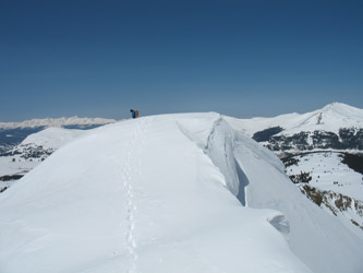 Once atop the first hump, we got a view of what the ridge would provide in the way of climbing. The ridge undulated gently and then took another short step up before again rising and falling through progressively deeper powder. We trekked along, content with an unexpected ridge climb including a brief one at a time wade across a powdery starting zone. The exposure is not bad, in my traveled eyes, but the terrain does fall off steeply to both sides and the snow lies in a suspect convex pillow atop the ridge. We climbed steadily until we reached the last steep section that likely climbs the better part of 600 to 800 vertical feet before reaching the juncture of the west ridge and the ridge coming north Wheeler Peak to the south. Again we were presented with a combination of good front pointing step kicking conditions and stretches of hard frozen snow that yielded little more purchase than a one inch ledge unless you took time for 3 kicks per step. Once atop the first hump, we got a view of what the ridge would provide in the way of climbing. The ridge undulated gently and then took another short step up before again rising and falling through progressively deeper powder. We trekked along, content with an unexpected ridge climb including a brief one at a time wade across a powdery starting zone. The exposure is not bad, in my traveled eyes, but the terrain does fall off steeply to both sides and the snow lies in a suspect convex pillow atop the ridge. We climbed steadily until we reached the last steep section that likely climbs the better part of 600 to 800 vertical feet before reaching the juncture of the west ridge and the ridge coming north Wheeler Peak to the south. Again we were presented with a combination of good front pointing step kicking conditions and stretches of hard frozen snow that yielded little more purchase than a one inch ledge unless you took time for 3 kicks per step.
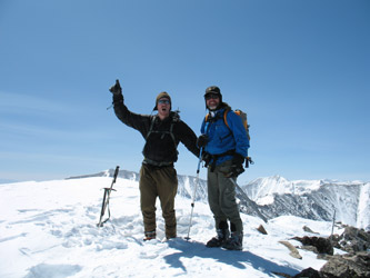
 None of us were using crampons, so we kicked nice steps and kept our ice axes at the ready in case of a slip. The climb was steep but comfortable for G and I, less so for Bob simply due to his lesser experience. We progressed steadily upward and broke the ridge proper and took a rest for a few minutes. As Bob had not submitted a high 13er or 14er in the winter, the final 150 feet of vertical were his to lead and after perhaps 8 or 10 minutes we all set off with Bob in the lead. The terrain was mixed snow and class 2/3 scrambling and within 15 minutes we were trudging along the brief summit ridge to the top of Drift Peak. None of us were using crampons, so we kicked nice steps and kept our ice axes at the ready in case of a slip. The climb was steep but comfortable for G and I, less so for Bob simply due to his lesser experience. We progressed steadily upward and broke the ridge proper and took a rest for a few minutes. As Bob had not submitted a high 13er or 14er in the winter, the final 150 feet of vertical were his to lead and after perhaps 8 or 10 minutes we all set off with Bob in the lead. The terrain was mixed snow and class 2/3 scrambling and within 15 minutes we were trudging along the brief summit ridge to the top of Drift Peak.
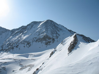
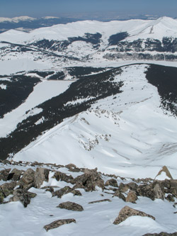
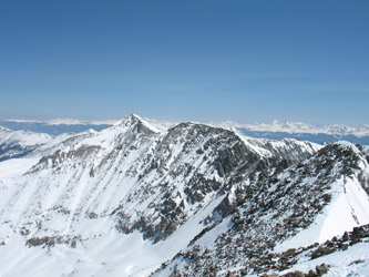
The view back down into Mayflower Gulch was impressive as we looked at our beaten path up the sinuous ridge. The route on to the summit of Fletcher was a high alpine ridge scramble, as advertised, and we decided to let that piece of ridge lie for another trip. We saw Quandary Peak from another side, the rugged side not traveled by the fearless summer Cottoneers who climb the peak in droves. We also looked at Pacific Peak in the distance and were duly impressed by the rugged nature of its ridge route as well. After perhaps 5 minutes on the chilly summit we were ready to descend the ridge in search of warmer feet and fingers.
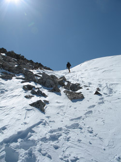
 The descend was event free though we did space ourselves out and cross the snow field at the base of the upper most steep section one at a time. The snow at this one spot has a wonderful convex roll and we figured if there was any one spot that might crack, this was it. After that, we made good time on back down the ridge to the ski stash at perhaps the12,000 foot mark. Some water, some Goo and we were all ready to get the skis on to make the final 1.5 distance with as little effort as possible. We all broke over the edge at the gap in the cornice and after attempting turns, G and Bob were down in the snow. I managed to extend my first leg long and make a fall free turn before scooting in a long leg into the vast open are below the cornice. I was not too worried about the cornice as the warm day that the forecast had called for never came. The descend was event free though we did space ourselves out and cross the snow field at the base of the upper most steep section one at a time. The snow at this one spot has a wonderful convex roll and we figured if there was any one spot that might crack, this was it. After that, we made good time on back down the ridge to the ski stash at perhaps the12,000 foot mark. Some water, some Goo and we were all ready to get the skis on to make the final 1.5 distance with as little effort as possible. We all broke over the edge at the gap in the cornice and after attempting turns, G and Bob were down in the snow. I managed to extend my first leg long and make a fall free turn before scooting in a long leg into the vast open are below the cornice. I was not too worried about the cornice as the warm day that the forecast had called for never came.
 We skied to the remains of the mine cabins below, all of us enjoying what for me was the finest patch of AT snow I'd experienced to date. A nice hard layer down about 2 inches and enough powder to take out all of the bumps. We skied in and out of one another's tracks and then dropped onto the road proper for the mile plus run to the truck. Ten minutes later we had skirted five groups, ten dogs and were back at the trail head, just a bit under eight hours after we started. No a bad day to catch a high 13'er, a snowy ridge, and a great ski out. We skied to the remains of the mine cabins below, all of us enjoying what for me was the finest patch of AT snow I'd experienced to date. A nice hard layer down about 2 inches and enough powder to take out all of the bumps. We skied in and out of one another's tracks and then dropped onto the road proper for the mile plus run to the truck. Ten minutes later we had skirted five groups, ten dogs and were back at the trail head, just a bit under eight hours after we started. No a bad day to catch a high 13'er, a snowy ridge, and a great ski out.
A spring snow climb of Fletcher Peak from Mayflower Gulch . . .
|
