The Jagged, Pigeon & Turret Mts. Attempt
August 7, 2012 - Upper Chicago Basin to Upper Noname Basin via Twin Thimbs Pass
The plan called for us to break camp and be on the trail to Twin Lakes by 5 a.m. at the latest. G and Bob would then climb Windom Peak while I remained with the packs, pulling guard duty against the marmots and goats that would surely take an interest in our provisions. We made the trek to the upper valley, climbing the relatively newly re- constructed trail up through the draw draining the lakes, avoiding the scree and other rougher sections that were once de rigor for the approach to the Weminuche 14'ers.
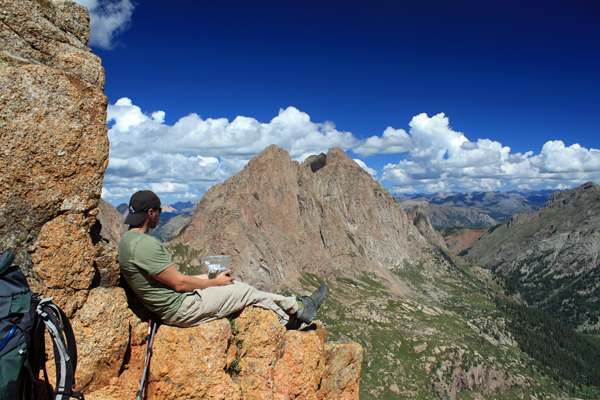
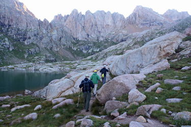 We arrived at the lakes in the early light of day and dropped the packs in a pile. G and Bob took a break and I prepared to keep an eye on the gear. We hoped for a rock face or other vertical feature that would let us hang everything on a rope but there really wasn't a good spot. I had already been up Windom so I opted to stay behind so that G and Bob could make the climb ultra light. They packed up their water and GU's in a single small day pack and were on the move with another fellow in tow. I harbored no doubts that they would summit and no more than two and half hours later, they arrived back at the packs, G having finished the 14'ers in the process. We arrived at the lakes in the early light of day and dropped the packs in a pile. G and Bob took a break and I prepared to keep an eye on the gear. We hoped for a rock face or other vertical feature that would let us hang everything on a rope but there really wasn't a good spot. I had already been up Windom so I opted to stay behind so that G and Bob could make the climb ultra light. They packed up their water and GU's in a single small day pack and were on the move with another fellow in tow. I harbored no doubts that they would summit and no more than two and half hours later, they arrived back at the packs, G having finished the 14'ers in the process.
 In the mean time, I fended off numerous goat advances, each well planned to draw my attention in one direction as another of the goat force approached from some unseen angle. Seriously they are not that swift, but they lack nothing in being patient for an opportunity or a turned back. As I fended off goats, numerous other parties came, rested and moved on to the various summits. What surprised me was the number who asked me such questions as "which way is Windom?" and "how do you get to Eolus?" I did not ask such questions back in my day, probably because I had a map, a semi tired looking pack, and the experience of 40 14'ers or so. I guess this is a sign of the times . . . a Basin full of raw Cottoneers out to bag their quota of 14'ers. In the mean time, I fended off numerous goat advances, each well planned to draw my attention in one direction as another of the goat force approached from some unseen angle. Seriously they are not that swift, but they lack nothing in being patient for an opportunity or a turned back. As I fended off goats, numerous other parties came, rested and moved on to the various summits. What surprised me was the number who asked me such questions as "which way is Windom?" and "how do you get to Eolus?" I did not ask such questions back in my day, probably because I had a map, a semi tired looking pack, and the experience of 40 14'ers or so. I guess this is a sign of the times . . . a Basin full of raw Cottoneers out to bag their quota of 14'ers.
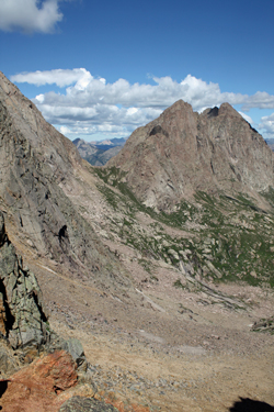
We gathered our gear and set off for Twin Thumbs, finding no trail but seeing climber's signs along the lower flank leading to a hidden flat about half way up. From there the trail was a bit more talus but still not loose until we nearly reached the pass proper, where a strong climber's trail cuts back and forth to knock out the last 50 feet of 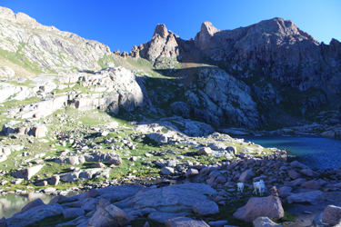 vertical. Without too much effort, we were all atop Twin Thumbs and looking out into the upper reaches of an arm of Noname Creek. We took a break, ate some of the beef jerky prepared for the trip and then hefted the packs once again to descend the really steep slope that dropped for the first 75 feet or so on the far side of the pass. We all took our time on this slope, moving back and forth on ledges, wishfully thinking that a bit on snow on this route would turn this from a leg breaker to a gentle heel stepping descent. But this was summer and we had to take our time to make the descent safely. vertical. Without too much effort, we were all atop Twin Thumbs and looking out into the upper reaches of an arm of Noname Creek. We took a break, ate some of the beef jerky prepared for the trip and then hefted the packs once again to descend the really steep slope that dropped for the first 75 feet or so on the far side of the pass. We all took our time on this slope, moving back and forth on ledges, wishfully thinking that a bit on snow on this route would turn this from a leg breaker to a gentle heel stepping descent. But this was summer and we had to take our time to make the descent safely.
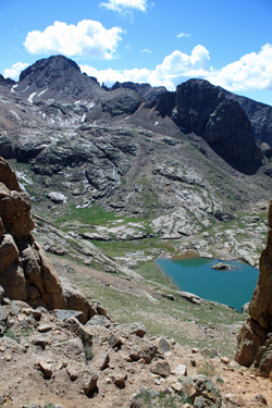 We all got down below the steep upper section, landing on a scree section where we began to traverse to the left to make our way to the saddle that would drop us into the Ruby Creek drainage. The route was not clear as to how far we would have to drop to make the traverse as there were a number of gullies and it would be unclear where the cliffs blocked passage until we got to the various break points. In hindsight, staying high treated us well and going lower, as originally seemed to be the best route, would not have worked at all. We traversed half way across to the upper Noname/Ruby saddle and then stopped to formulate a game plan. We were all carrying enough weight for the better part of a week so we thought do we (1) drop into the Ruby drainage knowing that we would later have to hump the weight back over into Noname, or (2) do we drop to a nice lake about halfway to the valley floor and set up spike camp where we could climb the Ruby peaks with almost no weight. We all got down below the steep upper section, landing on a scree section where we began to traverse to the left to make our way to the saddle that would drop us into the Ruby Creek drainage. The route was not clear as to how far we would have to drop to make the traverse as there were a number of gullies and it would be unclear where the cliffs blocked passage until we got to the various break points. In hindsight, staying high treated us well and going lower, as originally seemed to be the best route, would not have worked at all. We traversed half way across to the upper Noname/Ruby saddle and then stopped to formulate a game plan. We were all carrying enough weight for the better part of a week so we thought do we (1) drop into the Ruby drainage knowing that we would later have to hump the weight back over into Noname, or (2) do we drop to a nice lake about halfway to the valley floor and set up spike camp where we could climb the Ruby peaks with almost no weight.
 We opted for the drop as the clouds were coming in and we figured it would better to climb out of Ruby with no weight and in doing so make progress toward our climb of Jagged. We worked our way down to the first of a series of cliffs and found a passage down via some large talus, aiming for a grass slope that would give an easy descent. G led off, followed by Bob and I brought up the rear. About half way down, I inadvertently rolled my right ankle and went down hard on a rock. The camera rolled from the pack and I let out a string of expletives. What really bothered me was the snap . . crackle . . . and pop sound coming from my ankle as I went down. I do not know if the sound was in the air or in my bones but it was very much real, as was the pain that followed. I thought . . . is that what a snapping bone is like or did I just disconnect every ligament on the outside of the joint? We opted for the drop as the clouds were coming in and we figured it would better to climb out of Ruby with no weight and in doing so make progress toward our climb of Jagged. We worked our way down to the first of a series of cliffs and found a passage down via some large talus, aiming for a grass slope that would give an easy descent. G led off, followed by Bob and I brought up the rear. About half way down, I inadvertently rolled my right ankle and went down hard on a rock. The camera rolled from the pack and I let out a string of expletives. What really bothered me was the snap . . crackle . . . and pop sound coming from my ankle as I went down. I do not know if the sound was in the air or in my bones but it was very much real, as was the pain that followed. I thought . . . is that what a snapping bone is like or did I just disconnect every ligament on the outside of the joint?
Bob turned around after I called out and I asked him to come back and give me a hand with the camera, which had rolled down hill. He asked if I was OK as I was sitting there with my feet in front of me. I looked at him, not knowing whether to laugh or cry, and said simply that I was not OK but in fact that I 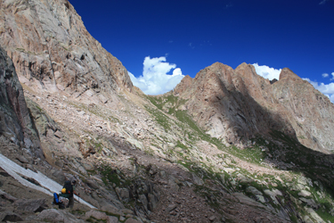 believed that I had broken my ankle. I followed that with the disappointing admission that I had just put an end to everyone's climbing trip and that I'd be along, just give me some space and solo time cause my ankle hurt like hell. He descended and I followed, making no pace whatsoever and gingerly working my way across talus to a path in the green grass around the small lake. I was more than halfway to tears but determined to make the camp spot when G came back and we talked about what had happened. I stopped at the lake and got my foot out of the shoe and sock and into the cold water, while G took my pack to the camp spot. believed that I had broken my ankle. I followed that with the disappointing admission that I had just put an end to everyone's climbing trip and that I'd be along, just give me some space and solo time cause my ankle hurt like hell. He descended and I followed, making no pace whatsoever and gingerly working my way across talus to a path in the green grass around the small lake. I was more than halfway to tears but determined to make the camp spot when G came back and we talked about what had happened. I stopped at the lake and got my foot out of the shoe and sock and into the cold water, while G took my pack to the camp spot.
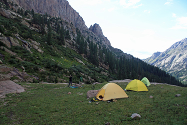
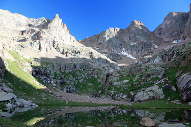 I iced the foot for about a twenty minutes before going the last 100 feet to the camp, hobbling on my hiking poles, where G had set up my tent and gotten my sleeping bag and pad laid out. We looked at the foot and it just did not look good and it sure did not feel good. I tried to walk it out but got only a few yards before I knew for sure, this simple roll was not going away with a bit of rubbing and a night of rest. I iced it for another hour over the next two hours, as the afternoon storm rolled through, and then we fixed dinner and discussed options. We agreed that the best option was a retreat to Needleton. The only problem was that we were only half way down the valley, a valley with no clear exit trail, and that meant I was faced with a morning bushwhack on a bum foot. We looked at the various routes from the rock buttress below the tents and G and Bob even poked around the area below camp before we called it a night. I iced the foot for about a twenty minutes before going the last 100 feet to the camp, hobbling on my hiking poles, where G had set up my tent and gotten my sleeping bag and pad laid out. We looked at the foot and it just did not look good and it sure did not feel good. I tried to walk it out but got only a few yards before I knew for sure, this simple roll was not going away with a bit of rubbing and a night of rest. I iced it for another hour over the next two hours, as the afternoon storm rolled through, and then we fixed dinner and discussed options. We agreed that the best option was a retreat to Needleton. The only problem was that we were only half way down the valley, a valley with no clear exit trail, and that meant I was faced with a morning bushwhack on a bum foot. We looked at the various routes from the rock buttress below the tents and G and Bob even poked around the area below camp before we called it a night.
 Actually, we had the PLB option as I bought a PLB three years before in case of a back country emergency. Push the button and ride a chopper out in the a.m . . . that option was certainly available . . . or we could walk out. Pushing the button would spread worry, at the very least, through three families, the hoof out option would be a more private experience that would last for no less than a couple of days and alarm nobody on the home front. The PLB option also brings to possibility of an accident involving search and rescue personnel coming to another's aid. My final analysis was that I was still mobile, though slow, and that unless that changed and I could not travel with the aid of poles, we would not use the PLB. I just did not see this as a immenent threat of death, call the cavalry, circumstance. Actually, we had the PLB option as I bought a PLB three years before in case of a back country emergency. Push the button and ride a chopper out in the a.m . . . that option was certainly available . . . or we could walk out. Pushing the button would spread worry, at the very least, through three families, the hoof out option would be a more private experience that would last for no less than a couple of days and alarm nobody on the home front. The PLB option also brings to possibility of an accident involving search and rescue personnel coming to another's aid. My final analysis was that I was still mobile, though slow, and that unless that changed and I could not travel with the aid of poles, we would not use the PLB. I just did not see this as a immenent threat of death, call the cavalry, circumstance.
Night came . . . a long night . . . and I struggled to sleep and somehow elevate my ace bandaged foot. I was cold, I was cold, I was cramped and I knew the next day would be a true backcountry adventure.
|
