Pyramid Peak
(two climbs 7 years apart, later climb on snow)
September 15, 2001 - Northeast Ridge
|
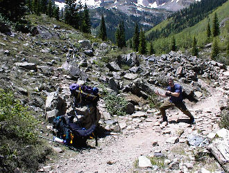
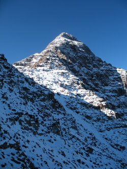
Could you possibly miss this cut off to Pyramid in the dark? |
Gary and I were looking at the onset of hunting season for him and another long semester of law school for me, neither of which is supportive of an active climbing schedule. We were determined to score another challenging peak and headed for Aspen to attempt Pyramid. Camping was sparse but we found a site that we could occupy for one night before we would have to move on in favor of the group who held a later reservation. The description of Pyramid indicated that we would have an eight-hour day ahead of us but we still planned an early start to avoid any afternoon storms, though none were predicted
|
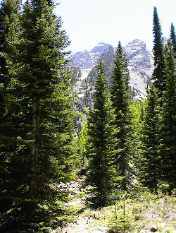
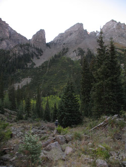
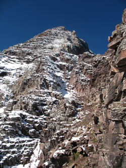
The route to the bowl, right up the center . . . after we found the trail. |
Neither of us had been up the Pyramid trail proper but we “knew” where the cut off was and headed out in the dark. Of course, we missed the cut off and went about 100 yards too far before deciding to cut back toward the peak, planning to intersect the trail with a traverse across the slope above. When one looks at the ascent up to the valley below the north face of Pyramid, it is obvious where the trail has to climb to get there. We traversed and hit the trail quite high up on the slope and found on our descent that we had paralleled the formal route for much of our initial climb.
|
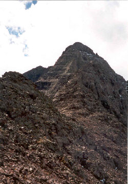
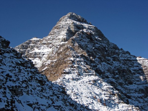
The Northeast Ridge route from the saddle |
The valley below Pyramid is a bowl filled with glacial till and as you approach the head of the valley, you come across a crater like depression, which demonstrates that the valley is an ice filled bowl with a covering of stone. We circled around the depression and followed the eastern bank of the moraine to the trail which switchbacks up to the saddle at the base of Pyramid’s northeastern ridge. Pyramid Peak is renowned for difficult route finding and exposure, a reputation well deserved. The initial portion of the climb was well cairned and we soon came to the ledges portion of the route. The ledges sound ominous but the exposure only about 15 feet and we had passed this point only to look back minutes later to realize that “those were the ledges”. The next challenge is the green colored stone band where the trail crosses through a steep couloir and then wraps up through the green rock to a series of ledges above. From this point, the route was much less well marked and the exposure increased substantially. The key way points mentioned in guidebooks are clearly seen above, but one must pick the correct route, not always to minimize the climbing difficulty but more to lessen the exposure in case of mishap. The climb can be made with no more than class 4 difficulty if the correct route is always selected but pulling that off will be a challenge. We ended up in some lower class 5 territory and upon weighing the 1000-foot exposure; we backed off and reassessed the route.
|
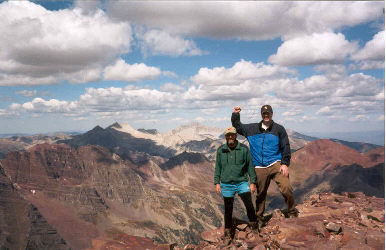
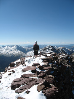
Howard and Gary atop Pyramid, Capital and Snowmass in the background |
After reaching an obvious skyline cleft the route shifts to an upward trending ledge system which places the climber on the summit of Pyramid. The view from Pyramid includes the Bells and at a much further distance, Capital and Snowmass. We ate lunch and headed down, finding that the correct route up is much more clearly visible on the descent. We picked our way down the ledges and onward to the base of the northeast ridge. Another rest and then down into the bowl below the north face and finally to the official trail that we had missed that morning. In hindsight, our morning route was a bit on the long side but surely, an easier climb than the deep gouge we descended. Nevertheless, our route finding bust had cost almost two hours and brought the total climb to about ten hours. Pyramid proved to be a tough climb but with proper route finding, the exposure and difficulty can be managed but not eliminated.
September 14, 2008 - Northeast Ridge - Snow
 Ed and I make a weekend climb just about every September, usually to score some out of the way 14'er that is still on his tick list and that he can convince me that I should climb again. One year we did Capital, then another time the north face of Castle, then Lindsey and this year, it was to be Pyramid. I'd been up the peak, literally on the same weekend but seven years prior. I'd tossed out the idea of a Pyramid climb a few weeks earlier as I knew that I'd be itching to climb something in September and that Ed would be willing to take a shot at another 14'er before winter proper arrived. And what better peak to go for than something in the Aspen area, especially if the leaves were beginning to change and the cottoneers had been driven off by the passing of Labor Day. Ed and I make a weekend climb just about every September, usually to score some out of the way 14'er that is still on his tick list and that he can convince me that I should climb again. One year we did Capital, then another time the north face of Castle, then Lindsey and this year, it was to be Pyramid. I'd been up the peak, literally on the same weekend but seven years prior. I'd tossed out the idea of a Pyramid climb a few weeks earlier as I knew that I'd be itching to climb something in September and that Ed would be willing to take a shot at another 14'er before winter proper arrived. And what better peak to go for than something in the Aspen area, especially if the leaves were beginning to change and the cottoneers had been driven off by the passing of Labor Day.
I met Ed at his place in Thornton, 1:20 south of Cheyenne and 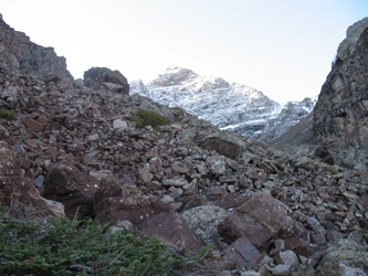 by 12:30 in the afternoon we we'd packed his car and were headed west hoping to score a campsite on the road to the bells and knowing that dinner would be at the Hickory Hut in Aspen. The September trip is now pretty much about tradition and with tradition comes food and in this case it has been and would remain the BBQ joint right past the second curve, coming into town. We first stopped at the Bells parking lot and having found that there were no open camp spots in the valley, we made for Difficult camp on the far side of Aspen. En route was dinner, as good as expected, and then were were off to get a campsite for the night before getting up not too early the next day for a bit of climbing. by 12:30 in the afternoon we we'd packed his car and were headed west hoping to score a campsite on the road to the bells and knowing that dinner would be at the Hickory Hut in Aspen. The September trip is now pretty much about tradition and with tradition comes food and in this case it has been and would remain the BBQ joint right past the second curve, coming into town. We first stopped at the Bells parking lot and having found that there were no open camp spots in the valley, we made for Difficult camp on the far side of Aspen. En route was dinner, as good as expected, and then were were off to get a campsite for the night before getting up not too early the next day for a bit of climbing.
 The weather had been very late fallish in Cheyenne and I had not seen the Front Range peaks in a week at least so when Ed suggested bringing an ice axe, I wondered why? But Saturday morning was clear as a bell and I knew as soon as I got to the Wyoming line on I-25 that I was glad that I brought both an axe and crampons. The peaks of the Front Range had 2000 feet of snow on them and I began to wonder what shape the Elks would be in, hoping that the answer would be dry. But that would not be the case as we found when drove up the Roaring Fork Valley and saw that there was every bit of 1500 to 2000 feet of snow on the higher Elk range peaks, Pyramid included. The weather had been very late fallish in Cheyenne and I had not seen the Front Range peaks in a week at least so when Ed suggested bringing an ice axe, I wondered why? But Saturday morning was clear as a bell and I knew as soon as I got to the Wyoming line on I-25 that I was glad that I brought both an axe and crampons. The peaks of the Front Range had 2000 feet of snow on them and I began to wonder what shape the Elks would be in, hoping that the answer would be dry. But that would not be the case as we found when drove up the Roaring Fork Valley and saw that there was every bit of 1500 to 2000 feet of snow on the higher Elk range peaks, Pyramid included.
 We woke at 4:45 and hoped to get to the parking lot and on up to the Pyramid Peak climber's trail by 6 a.m. We did not make very good time qnd took some time in the parking lot to gather our gear before Ed set a quick pace toward and around Maroon Lake. We did not know that the trail had been re-aligned and soon enough we were on some scenic loop and not seeing, in the darkness that was just beginning to break, the familiar trail that cut up and over the debris fan that separates Maroon from Crater Lake above. We spotted the old trail but not a new cut off . . . so our answer was a dainty cross country to avoid the old trail that is being restored while seeking to intercept the new alignment that surely was just a bit up the hillside. We found our route and by sun-up we were at the climber's trail cut-off. We woke at 4:45 and hoped to get to the parking lot and on up to the Pyramid Peak climber's trail by 6 a.m. We did not make very good time qnd took some time in the parking lot to gather our gear before Ed set a quick pace toward and around Maroon Lake. We did not know that the trail had been re-aligned and soon enough we were on some scenic loop and not seeing, in the darkness that was just beginning to break, the familiar trail that cut up and over the debris fan that separates Maroon from Crater Lake above. We spotted the old trail but not a new cut off . . . so our answer was a dainty cross country to avoid the old trail that is being restored while seeking to intercept the new alignment that surely was just a bit up the hillside. We found our route and by sun-up we were at the climber's trail cut-off.
 The old trail to the amphitheater below Pyramid was a real bear and ranged anywhere from water filled rut to loose talus and scree. That was in the past and now the trail has been re-aligned and the talus slopes tamed by steps . . . the old rutted cut is gone, nowhere to be seen. I will give credit due and say that the folks who reconstructed the trail did an absolutely magnificent job all the way to the cusp of the amphitheater. We hiked on up to the large bowl and then took a breather at one of the large cairns that marks the now rock hopping course across the topographic lip that marks the start of the middle third of the climb. Another climber, Ross caught up to us at this point and after a few minutes, the three of us set off in a flurry of chat. The old trail to the amphitheater below Pyramid was a real bear and ranged anywhere from water filled rut to loose talus and scree. That was in the past and now the trail has been re-aligned and the talus slopes tamed by steps . . . the old rutted cut is gone, nowhere to be seen. I will give credit due and say that the folks who reconstructed the trail did an absolutely magnificent job all the way to the cusp of the amphitheater. We hiked on up to the large bowl and then took a breather at one of the large cairns that marks the now rock hopping course across the topographic lip that marks the start of the middle third of the climb. Another climber, Ross caught up to us at this point and after a few minutes, the three of us set off in a flurry of chat.
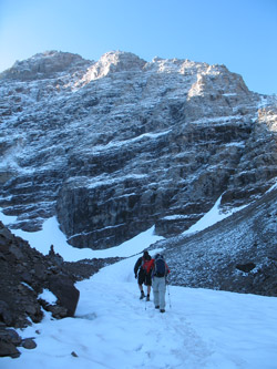
 The amphitheater was as I remember it . . . nothing but rock, in fact it has all the look of what I suspect it to be and that is a stationary dirty ice field. We stuck to the now much less marked trail but if you are climbing Pyramid without a guide and are marginally competent, you ought ought be able to spot the wear on the rocks well enough to pick your way along the trail to the side west side of the bowl and pick up either the snowfield that snakes its way all the way up and around to the slope below the climb up the northwest ridge. I really did not want to kick quasi steps in the hard snow slope so I stuck to the rock on the side and took a well beaten trail up to a crossing of the snow and then over the morainal rock to the base of the scree climb to the saddle below the northwest ridge. The amphitheater was as I remember it . . . nothing but rock, in fact it has all the look of what I suspect it to be and that is a stationary dirty ice field. We stuck to the now much less marked trail but if you are climbing Pyramid without a guide and are marginally competent, you ought ought be able to spot the wear on the rocks well enough to pick your way along the trail to the side west side of the bowl and pick up either the snowfield that snakes its way all the way up and around to the slope below the climb up the northwest ridge. I really did not want to kick quasi steps in the hard snow slope so I stuck to the rock on the side and took a well beaten trail up to a crossing of the snow and then over the morainal rock to the base of the scree climb to the saddle below the northwest ridge.
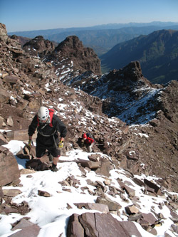
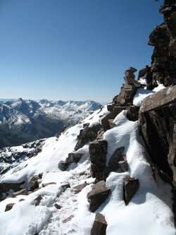
 The climb to the ridge proper is a combination of scree and trail segments that, on this climb, were mud segments. The gain in elevation is probably the better part of 700 feet and we worked hard for the gain. The slope becomes more gradual toward the top and as we found on our descent, it does not really matter if you hang left or right, you will get to the saddle at the top. We were still in shadow until we reached the saddle and then we were treated to the full warmth of the sun as well as a great view of the remainder of the route, all snow but for the lowest portion of the ridge. The peak looked great in its white mantle but the snow was telling my inner climber that this could be a bit more challenging than when I climbed it before, both on a friction and route finding basis. The climb to the ridge proper is a combination of scree and trail segments that, on this climb, were mud segments. The gain in elevation is probably the better part of 700 feet and we worked hard for the gain. The slope becomes more gradual toward the top and as we found on our descent, it does not really matter if you hang left or right, you will get to the saddle at the top. We were still in shadow until we reached the saddle and then we were treated to the full warmth of the sun as well as a great view of the remainder of the route, all snow but for the lowest portion of the ridge. The peak looked great in its white mantle but the snow was telling my inner climber that this could be a bit more challenging than when I climbed it before, both on a friction and route finding basis.
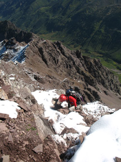
 We stopped for a few minutes to shoot a goo, chug some water or Cytomax and then started on up the best part of the climb. By this point Ross had stuck with us this far and we had pretty much gelled as an agreeable climbing party of three. I've done enough solo climbing to know what fun it can be to snag another climber on the way and Ross brought some great climbing conversation to the group. I took the lead along the traverse of the short pinnacle that you must bypass to reach the formal start of the climb and then I continued the climbing traverse, connecting a cairns here and there to eventually cross over a fin and look down at the "ledge" section of the climb. I've read stories online of woe as to the character of the ledge but honestly, the exposure is all of 40 feet and short of being icy, it is just a brief sideways skirt to move beyond the narrowest section.iest We stopped for a few minutes to shoot a goo, chug some water or Cytomax and then started on up the best part of the climb. By this point Ross had stuck with us this far and we had pretty much gelled as an agreeable climbing party of three. I've done enough solo climbing to know what fun it can be to snag another climber on the way and Ross brought some great climbing conversation to the group. I took the lead along the traverse of the short pinnacle that you must bypass to reach the formal start of the climb and then I continued the climbing traverse, connecting a cairns here and there to eventually cross over a fin and look down at the "ledge" section of the climb. I've read stories online of woe as to the character of the ledge but honestly, the exposure is all of 40 feet and short of being icy, it is just a brief sideways skirt to move beyond the narrowest section.iest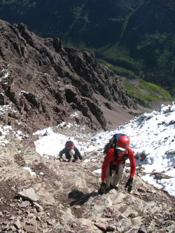 We passed beyond the ledge and continued upward, cutting right to leave the obvious couloir and traverse around to the start of what is called the "green couloir." It was not looking green today as it was mostly snow but with enough rock to give good holds and solid footing. This section seems to be mostly solid rock with its bedding such that the class 3 climbing is, for for me, of little challenge. We gained perhaps 200 vertical on this rock before cutting again to the right to re-enter the slabby red sedimentary rock the Bells and Pyramid are known for. From there on it was just a case of doing the weave back and forth to gain the summit. There were a few cuts left and a few more right including a couple of class 4 pitches that flirted with some of the most serious multiple hundred foot exposure spots the peak has to offer. We passed beyond the ledge and continued upward, cutting right to leave the obvious couloir and traverse around to the start of what is called the "green couloir." It was not looking green today as it was mostly snow but with enough rock to give good holds and solid footing. This section seems to be mostly solid rock with its bedding such that the class 3 climbing is, for for me, of little challenge. We gained perhaps 200 vertical on this rock before cutting again to the right to re-enter the slabby red sedimentary rock the Bells and Pyramid are known for. From there on it was just a case of doing the weave back and forth to gain the summit. There were a few cuts left and a few more right including a couple of class 4 pitches that flirted with some of the most serious multiple hundred foot exposure spots the peak has to offer.
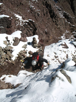 I remembered the hairiest section from years before and knew to traverse ten feet or so to the right to put the exposure out of the way and make another ten feet of gain without the life insurance worries. Once beyond those the tougher sections we cut left for the last time and gained perhaps the final 150 feet of climb to reach the summit. Ross scored the summit first, having taken a slightly different route but Ed and I soon followed. We took in the view of Capitol, Snowmass, the Bells and even got Ross the hero shot that puts the Bells in perfect focus in the background. We ate lunch, broke out the obligatory gummi worms and Ed even renewed his Bob club membership while cavorting with the drop offs that surrounded his lofty throne. I remembered the hairiest section from years before and knew to traverse ten feet or so to the right to put the exposure out of the way and make another ten feet of gain without the life insurance worries. Once beyond those the tougher sections we cut left for the last time and gained perhaps the final 150 feet of climb to reach the summit. Ross scored the summit first, having taken a slightly different route but Ed and I soon followed. We took in the view of Capitol, Snowmass, the Bells and even got Ross the hero shot that puts the Bells in perfect focus in the background. We ate lunch, broke out the obligatory gummi worms and Ed even renewed his Bob club membership while cavorting with the drop offs that surrounded his lofty throne.
 We were on the summit for forty minutes or so before hefting the packs and starting our way down the sometimes wet and muddy ledges leading back to the ridge far below. The descent down to the exposed section went well and we all dropped easily down the short step but ten feet from the most exposed portion of the route. We stepped to the left, acquired the route down through the green couloir and then cut left again at its base to move over into the and across the next gully over. We noted where a group ahead of us had stayed high and then cut down over a fin but thought it best to make our way down as we had come up. We had spotted another group climbing up and we met them perhaps 100 yards upclimb of the ledges section. A group of seven with a full range of confidence ranging from a "we will take it slow" leader to a number of tail enders all seeming a bit concerned about their progress and the terrain ahead. We were on the summit for forty minutes or so before hefting the packs and starting our way down the sometimes wet and muddy ledges leading back to the ridge far below. The descent down to the exposed section went well and we all dropped easily down the short step but ten feet from the most exposed portion of the route. We stepped to the left, acquired the route down through the green couloir and then cut left again at its base to move over into the and across the next gully over. We noted where a group ahead of us had stayed high and then cut down over a fin but thought it best to make our way down as we had come up. We had spotted another group climbing up and we met them perhaps 100 yards upclimb of the ledges section. A group of seven with a full range of confidence ranging from a "we will take it slow" leader to a number of tail enders all seeming a bit concerned about their progress and the terrain ahead.
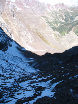
 We crossed the ledge again and then Ross took the lead on down the ridge proper to the small saddle before one traverses around the higher ground to land once again on the saddle at the top of the couloir climb leading up from the upper end of the amphitheater. We took a couple of minutes rest and then dropped down the mostly muddy slope to the amphitheater below where we opted to take the snow hike across the late season snow fields rather than the boulder hop across the moraine proper. The later portion of the snow gave many opportunities for standing and sometimes sitting glissades but I was really quite glad to reach the drop off where I knew there was good trail and solid footing to the car below. We crossed the ledge again and then Ross took the lead on down the ridge proper to the small saddle before one traverses around the higher ground to land once again on the saddle at the top of the couloir climb leading up from the upper end of the amphitheater. We took a couple of minutes rest and then dropped down the mostly muddy slope to the amphitheater below where we opted to take the snow hike across the late season snow fields rather than the boulder hop across the moraine proper. The later portion of the snow gave many opportunities for standing and sometimes sitting glissades but I was really quite glad to reach the drop off where I knew there was good trail and solid footing to the car below.
 The trail down from the amphitheater was wonderful and soon enough we hit the debris fan at the bottom of the valley and then made for a very brisk hike out the last mile or so to the car. We were on the peak for about ten hours and managed to score it with a mantle of snow over the upper 1500 feet of the mountain. I did not plan a snowy climb of one of the tougher Elk Range peaks but as we climbed everything felt right, hence the three of us scored a summit and Ed and Ross got new 14'ers for their lists. The trail down from the amphitheater was wonderful and soon enough we hit the debris fan at the bottom of the valley and then made for a very brisk hike out the last mile or so to the car. We were on the peak for about ten hours and managed to score it with a mantle of snow over the upper 1500 feet of the mountain. I did not plan a snowy climb of one of the tougher Elk Range peaks but as we climbed everything felt right, hence the three of us scored a summit and Ed and Ross got new 14'ers for their lists.
|
