Bard Peak
April 1, 2012 - via the Bakerville Bushwhack & Southern Slope
I'd climbed the week before and gone on a long bike ride the previous day so when I saw the weather forecast calling for 40 mph winds with gusts to 60 mph, I was not to enthused about a drive south to climb Bard Peak. The alarm went off at 5:15 and I rolled over to go back to sleep, I really figured the wind would be howling and I knew I would be solo, hence just suffering without a fellow climber to be equally chilled. However, something brought me from bed to the computer at 6:00 and I noted that that the temp in Georgetown was already 50 degrees with but a 20 mph wind. I figured the wind might be blowing up high but the temps were right for a day out. I departed Cheyenne at 6:15 a.m (truck and gear were pre-packed . . . just in case ;)
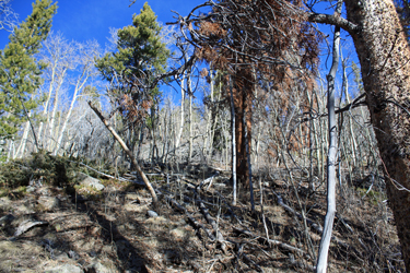 I arrived at the Bakerville trailhead at a bit before 9 a.m., not really psyched about this alleged very steep bushwhack through the trees to break tree line, all sans trail and likely in the snow. But on the drive up, I noted the snow line was pretty high and as I parked I could see snow high in the trees on the opposite side of the valley. My route would be up a more southerly facing route, hence I thought I'd give it a shot. I hefted the pack, decided to leave the snowshoes in the truck and figured to just give it a shot. I arrived at the Bakerville trailhead at a bit before 9 a.m., not really psyched about this alleged very steep bushwhack through the trees to break tree line, all sans trail and likely in the snow. But on the drive up, I noted the snow line was pretty high and as I parked I could see snow high in the trees on the opposite side of the valley. My route would be up a more southerly facing route, hence I thought I'd give it a shot. I hefted the pack, decided to leave the snowshoes in the truck and figured to just give it a shot.
 I took the guidebook suggested route, which calls for going a bit west of the bridge over I-70 and then start up the stream course, staying on the est side for a more clear route. The route was a true bushwhack but I figured it would take an hour and a half and I could just make the best of a mindless uphill struggle. I pushed up through small dead fall and through a small rock band before dropping back down and coming up fairly close to the creek. The terrain was now more open as I had gained a few hundred vertical feet and I climbed slowly upward for another five minutes before I spotted what looked like an overflow channel for the stream. It was no overflow channel, it was a very strong trail, heading up valley, in just the direction I needed to go. I took the guidebook suggested route, which calls for going a bit west of the bridge over I-70 and then start up the stream course, staying on the est side for a more clear route. The route was a true bushwhack but I figured it would take an hour and a half and I could just make the best of a mindless uphill struggle. I pushed up through small dead fall and through a small rock band before dropping back down and coming up fairly close to the creek. The terrain was now more open as I had gained a few hundred vertical feet and I climbed slowly upward for another five minutes before I spotted what looked like an overflow channel for the stream. It was no overflow channel, it was a very strong trail, heading up valley, in just the direction I needed to go.
The operative word for this trail is steep, the topo says one has to gain and gain elevation one does for a good quarter mile before the terrain flattens out again and steep was replaced by the new operative word . . . snow. The woods now thickened and the shadows and gain in elevation allowed for the snow to remain through the recent warm spell. It started off in patches, then a solid blanket of 8" going up to about 24 " before reaching tree line. I was in luck; however, as there was at least one person ahead of me and he was stomping a well crafted track. I could not really tell if it was one or two 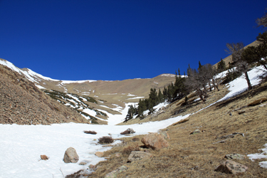 persons but I did not care so long as they remained enthused of the idea of getting to the open slopes above tree line. My hunch was in favor of "they" and on that assumption, they cut left and cut right, crossed logs and rock hopped where given the chance. persons but I did not care so long as they remained enthused of the idea of getting to the open slopes above tree line. My hunch was in favor of "they" and on that assumption, they cut left and cut right, crossed logs and rock hopped where given the chance.
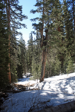
After about a quarter mile of effort, the stream channel became more defined as the trees rapidly opened and the bare slopes of the valley that lay between Parnassus and Bard lay before me. The map showed a wide drainage that would lead to the saddle between the two peaks.
 The base of the drainage looked to be filled with snow and after I climbed a hundred feet of it, I realized that regardless of the sun, it had enough depth and cold to remain firm. The snow line appeared to be continuous and after about a quarter mile, it cut to the right and climbed toward the saddle. I rest stepped a steady track upward, the snow warm enough to give a good step ut still cold enough to obviate any avi issues. The rest step is made for this type of terrain and faithfully practiced it for the next 1500 vertical feet to a point just one or two hundred feet below the saddle where the snow line petered out. The base of the drainage looked to be filled with snow and after I climbed a hundred feet of it, I realized that regardless of the sun, it had enough depth and cold to remain firm. The snow line appeared to be continuous and after about a quarter mile, it cut to the right and climbed toward the saddle. I rest stepped a steady track upward, the snow warm enough to give a good step ut still cold enough to obviate any avi issues. The rest step is made for this type of terrain and faithfully practiced it for the next 1500 vertical feet to a point just one or two hundred feet below the saddle where the snow line petered out.
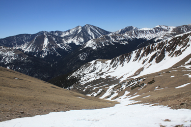
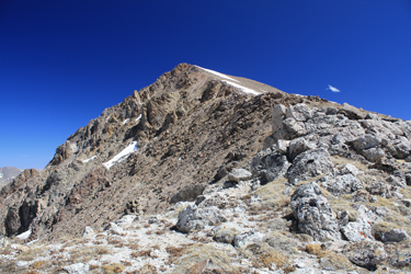
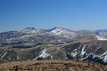
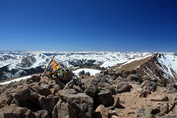
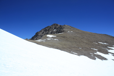 I stepped off the snow and covered a hundred yards of bare ground before getting back on a snow lense that lay below the saddle proper. At this point, I still could not quite see the summit of Bard or Parnassus though the map told where each lay. I broke the saddle and then had the summit of Bard in sight, along with two figures descending from the high point. I cut to the right and started a gentle traversing climb to along the scalloped back of the summit pyramid, seeing that this peak had a cliffy side and a gentle slope side. The first hump yielded after a few minutes climb and then I simply stepped out the distance to the summit proper, marked by a mound of rocks, USCGS benchmark and a stick pointing semi upward. I stepped off the snow and covered a hundred yards of bare ground before getting back on a snow lense that lay below the saddle proper. At this point, I still could not quite see the summit of Bard or Parnassus though the map told where each lay. I broke the saddle and then had the summit of Bard in sight, along with two figures descending from the high point. I cut to the right and started a gentle traversing climb to along the scalloped back of the summit pyramid, seeing that this peak had a cliffy side and a gentle slope side. The first hump yielded after a few minutes climb and then I simply stepped out the distance to the summit proper, marked by a mound of rocks, USCGS benchmark and a stick pointing semi upward.
 I took the required summit photos, ate a half power bar and took a few sips from the water bladder before hefting the pack for the trip down. I could see the Bakerville exit from the summit but figured there was a good hour and a half of hiking between me and the bottom end of the trail. The descent was easy down to the top of the slow line and then even easier as the conditions were perfect for a standing glissade. I much prefer the standing version over the ass on snow variety, the behind stays warm and the standing version is a bit more styling' in my book. I made short work of 1500 feet of now softening snow. Once back in the woods, I heard voices ahead and within a minute or two passed the two fellows who had stomped the original track. I took the required summit photos, ate a half power bar and took a few sips from the water bladder before hefting the pack for the trip down. I could see the Bakerville exit from the summit but figured there was a good hour and a half of hiking between me and the bottom end of the trail. The descent was easy down to the top of the slow line and then even easier as the conditions were perfect for a standing glissade. I much prefer the standing version over the ass on snow variety, the behind stays warm and the standing version is a bit more styling' in my book. I made short work of 1500 feet of now softening snow. Once back in the woods, I heard voices ahead and within a minute or two passed the two fellows who had stomped the original track.
 I had a fast pace so I offered to take the lead and put a good stomp in place for them. One had snowshoes so had I been on the ball I'd have slowed to allow him to pack a proper trail, but I was ready to call it a day so I took the lead with proper thanks and compliments as to the approach that morning. After 15 minutes of postholing here and there, I broke out of the snow to the steep portion of the trail, dispatched that section in good time and instead of cutting off where I had joined the trail that a.m., I continued down the well developed trail to almost the elevation of the highway. Feeling I had gone a bit too far west, I bushwhacked to the highway and then hoofed about 5 minutes back down the shoulder of the road to the Bakerville exit and my waiting truck. Overall a 4 hour climb to cover about 2 1/2 miles and 4000 vertical feet and a retreat over the same terrain in 1.5 hours flat. I had a fast pace so I offered to take the lead and put a good stomp in place for them. One had snowshoes so had I been on the ball I'd have slowed to allow him to pack a proper trail, but I was ready to call it a day so I took the lead with proper thanks and compliments as to the approach that morning. After 15 minutes of postholing here and there, I broke out of the snow to the steep portion of the trail, dispatched that section in good time and instead of cutting off where I had joined the trail that a.m., I continued down the well developed trail to almost the elevation of the highway. Feeling I had gone a bit too far west, I bushwhacked to the highway and then hoofed about 5 minutes back down the shoulder of the road to the Bakerville exit and my waiting truck. Overall a 4 hour climb to cover about 2 1/2 miles and 4000 vertical feet and a retreat over the same terrain in 1.5 hours flat.
|
