Longs Peak
July 22, 2007 - North Face, a.k.a. Cable Route - Summer
G and I had done the North Face on the eve of the huge blizzard of 2003 and with a trip to Bolivia looming, we figured it would be a good way to test our level of fitness, not that there was a great deal of time to remedy any shortfalls exposed in the process. We agreed to leave Cheyenne at midnight to get a start up the trail at 2 a.m., a reasonable time for a summer climb of Longs Peak by most of the mere mortal routes. We stopped for gas and were on our way to Estes Park and the Longs Peak trail head parking lot. We arrived at 2:15 and found, perhaps not totally surprisingly, that but for just a few spots, the lot was nearly full. By the time we gathered our gear and started on the trail, at 2:30, the lot was literally full.
 We've been up this trail so many times, winter and summer that every turn and switchback are committed to memory. We each carried a half quart of water, knowing that we could pump more at multiple points along the way, hence no need to lug the extra weight. The morning was warm, perhaps too warm as we set a respectable pace and soon sweated our backs, making for a nice chill when we stopped and took off the pack. We had a bit of weight on as I was carrying a 60 meter 9.4mm rope and G had our rock rack. We covered the first two miles in an hour and stopped to pump a full quart each at the last creek crossing before the trail breaks the tree line. Water pumped, we moved on through the last of the trees and through the krumholz, climbing toward the Chasm Lake junction. We've been up this trail so many times, winter and summer that every turn and switchback are committed to memory. We each carried a half quart of water, knowing that we could pump more at multiple points along the way, hence no need to lug the extra weight. The morning was warm, perhaps too warm as we set a respectable pace and soon sweated our backs, making for a nice chill when we stopped and took off the pack. We had a bit of weight on as I was carrying a 60 meter 9.4mm rope and G had our rock rack. We covered the first two miles in an hour and stopped to pump a full quart each at the last creek crossing before the trail breaks the tree line. Water pumped, we moved on through the last of the trees and through the krumholz, climbing toward the Chasm Lake junction.
 To say that there were other folks on the trail would be an understatement. We looked at the flank of Mt. Lady Washington and saw the bouncing dots of headlamps on the heads of those who had an earlier start. To our rear, there was a similar string of lights for those starting later. I climbed Longs in 1999 and there were perhaps 40 people on the summit at 8:30 . . . I expected the same experience today. We made the Chasm Lake junction and without stopping continued upward toward Granite Pass. I recalled that in 2007, when we did this route in winter, it took us about 4 hours to reach the pass, we would do it today in 3 hours. To say that there were other folks on the trail would be an understatement. We looked at the flank of Mt. Lady Washington and saw the bouncing dots of headlamps on the heads of those who had an earlier start. To our rear, there was a similar string of lights for those starting later. I climbed Longs in 1999 and there were perhaps 40 people on the summit at 8:30 . . . I expected the same experience today. We made the Chasm Lake junction and without stopping continued upward toward Granite Pass. I recalled that in 2007, when we did this route in winter, it took us about 4 hours to reach the pass, we would do it today in 3 hours.
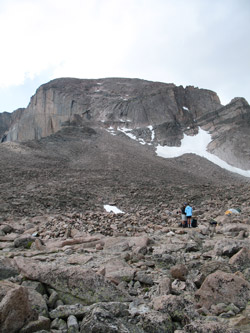
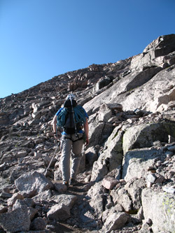
 The route to the North Face or Cables route is the same as the popular Keyhole, until just before the Boulderfield. One can cut off at or beyond the Boulderfield camp area and we cut off toward the North Face before getting to the camp area. We boulder hopped toward the talus cone that leads up the technical pitch that is the crux of a North Face climb. Our quick pace slowed as we were gaining more elevation with every step and working to keep our balance as we moved from rock to rock. We intercepted the trail trace and fragments that lead to the base of the crux pitch and just connected the dots to the vicinity of Chasm View. The route to the North Face or Cables route is the same as the popular Keyhole, until just before the Boulderfield. One can cut off at or beyond the Boulderfield camp area and we cut off toward the North Face before getting to the camp area. We boulder hopped toward the talus cone that leads up the technical pitch that is the crux of a North Face climb. Our quick pace slowed as we were gaining more elevation with every step and working to keep our balance as we moved from rock to rock. We intercepted the trail trace and fragments that lead to the base of the crux pitch and just connected the dots to the vicinity of Chasm View.
 When we climbed this route in 2003, the entire slope leading to the base of the crux was well consolidated snow, hence we were climbing with axes and crampons. Today is was approach shoes and losing a step here and there as the scree underfoot did its job. We arrived near the Chasm View drop off and looked up to spot an eyebolt or two to identify the proper crack to climb to the easier slopes above. We spotted one and then made our way up a steeply inclined ramp in the granite to a flat area below the crux pitch. We were still not there yet as we had to climb another Class 3/4 pitch to gain the lowest eyebolt. When we climbed this route in 2003, the entire slope leading to the base of the crux was well consolidated snow, hence we were climbing with axes and crampons. Today is was approach shoes and losing a step here and there as the scree underfoot did its job. We arrived near the Chasm View drop off and looked up to spot an eyebolt or two to identify the proper crack to climb to the easier slopes above. We spotted one and then made our way up a steeply inclined ramp in the granite to a flat area below the crux pitch. We were still not there yet as we had to climb another Class 3/4 pitch to gain the lowest eyebolt.
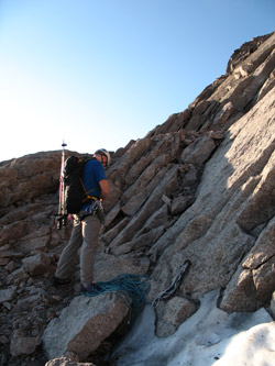
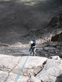
 When we climbed this route in winter, we never saw the lower bolt as it was well buried in the snow. this time it was there in plain view and we chose to use it as a belay anchor. G would lead the climb and I set up a belay while he laid out the rope, put the rack in order and tied into the line. He moved confidently up the pitch, utilizing six pieces of protection and two remaining eye bolts for his ascent and top anchor (3 nuts, 1 cam, and 1 tri-cam). The climb is rated 5.4 by Dawson and that appeared to be an accurate rating, based upon our experience on this climb. (Go read the Disclaimer again and remember the subjective (opinion) nature of any rating). When we climbed this route in winter, we never saw the lower bolt as it was well buried in the snow. this time it was there in plain view and we chose to use it as a belay anchor. G would lead the climb and I set up a belay while he laid out the rope, put the rack in order and tied into the line. He moved confidently up the pitch, utilizing six pieces of protection and two remaining eye bolts for his ascent and top anchor (3 nuts, 1 cam, and 1 tri-cam). The climb is rated 5.4 by Dawson and that appeared to be an accurate rating, based upon our experience on this climb. (Go read the Disclaimer again and remember the subjective (opinion) nature of any rating).
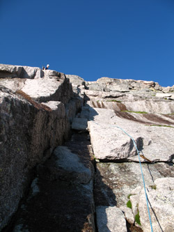
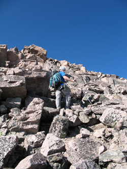 G tied in at the top and within just a minute or two, I was climbing with the security of a top rope. When I reached the top, we untied from the belay point and packed away the rope and rack for the climb to the summit above. I did not find that the route to the summit involved any serious degree of route finding as there were multiple cairns and trail segments, all easily connected. Bear in mind, that our eyes have looked for routes on well over 100 14'er climbs and multiple peaks ranging from the Canadian Rockies to Bolivia. A discriminating eye will pick up the route, a less experienced eye should carefully note the top of the technical pitch, so that it can be located on the descent. G tied in at the top and within just a minute or two, I was climbing with the security of a top rope. When I reached the top, we untied from the belay point and packed away the rope and rack for the climb to the summit above. I did not find that the route to the summit involved any serious degree of route finding as there were multiple cairns and trail segments, all easily connected. Bear in mind, that our eyes have looked for routes on well over 100 14'er climbs and multiple peaks ranging from the Canadian Rockies to Bolivia. A discriminating eye will pick up the route, a less experienced eye should carefully note the top of the technical pitch, so that it can be located on the descent.
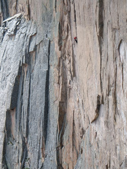
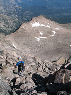 We traversed the North Face, steadily climbing between two bands of more steep rock before turning more sharply upward and climbing atop boulders and scrambling up steep sections of the slope. The difficulty never exceeded hand and foot climbing, so long as the proper route was selected and the smoothed rock bands were avoided. Remember, the North Face is above the Diamond Face. You do not want to let any rock get loose and you don't want to imitate any of the loose rock that could potentially plummet down the Diamond. If the weather is good, there will be folks on that wall. The summit came quickly and soon we were looking at a crowd of Cottoneers, all of who had made the summit via the Keyhole Route. We traversed the North Face, steadily climbing between two bands of more steep rock before turning more sharply upward and climbing atop boulders and scrambling up steep sections of the slope. The difficulty never exceeded hand and foot climbing, so long as the proper route was selected and the smoothed rock bands were avoided. Remember, the North Face is above the Diamond Face. You do not want to let any rock get loose and you don't want to imitate any of the loose rock that could potentially plummet down the Diamond. If the weather is good, there will be folks on that wall. The summit came quickly and soon we were looking at a crowd of Cottoneers, all of who had made the summit via the Keyhole Route.
 For those not in the know, Cottoneers are the jeans clad and tennis shoe borne individuals who, after the snows melt, ascend to the top of the 14'ers, generally woefully short of the proper gear for an emergency or substantive change in the weather. Of course, not everyone was a Cottoneer but there were more than a few I assure you. We snacked and remained on the summit for one half hour before hefting the packs for the trip back down. For those not in the know, Cottoneers are the jeans clad and tennis shoe borne individuals who, after the snows melt, ascend to the top of the 14'ers, generally woefully short of the proper gear for an emergency or substantive change in the weather. Of course, not everyone was a Cottoneer but there were more than a few I assure you. We snacked and remained on the summit for one half hour before hefting the packs for the trip back down.
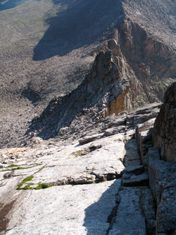
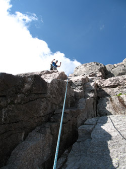
 We reversed our path, picking up the trail segments and cairns as indicative of our being on the correct course to our drop off point. We met another party at the top of the pitch and as they were completing their ascent, we were able to go right to the task of setting up our rappel to the top of the talus cone below. While we were able to climb the crux in one pitch, it would take two rappels on the doubled rope to make our way back to our lower starting point. We made the rappels, stopping to reset the rope at the projecting eyebolt, located at about the middle of the crux. We reversed our path, picking up the trail segments and cairns as indicative of our being on the correct course to our drop off point. We met another party at the top of the pitch and as they were completing their ascent, we were able to go right to the task of setting up our rappel to the top of the talus cone below. While we were able to climb the crux in one pitch, it would take two rappels on the doubled rope to make our way back to our lower starting point. We made the rappels, stopping to reset the rope at the projecting eyebolt, located at about the middle of the crux.
 The gathered our gear and set off for the boulder field, but no before taking in the view from Chasm View. We could see perhaps five two person pairs on the Diamond, slowly working their way up the vertical face. Not my game . . . but I must give them credit. We broke out the hiking poles and were off to the Boulderfield, taking trail segments that let us intersect the main Keyhole trail just above the camping area. We were now moving smartly along and but for a stop at the snow melt stream at the lower boundary of the Boulderfield, we stopped only for a few seconds here and there for a drink on the way back to the truck far below. We were done at about 2:20 in the afternoon, a time we could have cut back to about 1:30 had we elected to tag the summit and refrain from a summit snack and the second 20 minute rest at the terminus of the Boulderfield. In contrast to our 15 1/2 hour winter ascent, we did the same route, with some relaxed moments, in 12 hours. The gathered our gear and set off for the boulder field, but no before taking in the view from Chasm View. We could see perhaps five two person pairs on the Diamond, slowly working their way up the vertical face. Not my game . . . but I must give them credit. We broke out the hiking poles and were off to the Boulderfield, taking trail segments that let us intersect the main Keyhole trail just above the camping area. We were now moving smartly along and but for a stop at the snow melt stream at the lower boundary of the Boulderfield, we stopped only for a few seconds here and there for a drink on the way back to the truck far below. We were done at about 2:20 in the afternoon, a time we could have cut back to about 1:30 had we elected to tag the summit and refrain from a summit snack and the second 20 minute rest at the terminus of the Boulderfield. In contrast to our 15 1/2 hour winter ascent, we did the same route, with some relaxed moments, in 12 hours.
All in all a solid alpine day under mostly partly cloudy skies, no wind of note, and temperatures that were simply too warm to be expected or honestly, to be wished for above treeline. We also realized that the summer route lacks the crampon cruise that makes the talus cone an easier affair. I think it fair to say that a snowed in dihedral, as we experienced it in 2003, made for an easier climb than the summer "rock only" version.
|
