Traver, McNamee & Clinton Peaks
May 16, 2009 - Southwest Face from Climax Mine/Fremont Parking
 Gerry Roach's Thirteener's Guide tells of must climb couloir on the southwest face of Traver Peak. He also provides a well placed caveat that you have to get it when the snow is in the right shape. It is a great couloir climb and yes, you do want to get it when the conditions are aligned for a crampon cruise. Gerry Roach's Thirteener's Guide tells of must climb couloir on the southwest face of Traver Peak. He also provides a well placed caveat that you have to get it when the snow is in the right shape. It is a great couloir climb and yes, you do want to get it when the conditions are aligned for a crampon cruise.
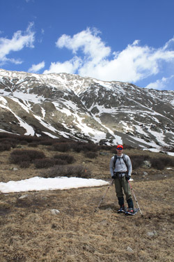
Bob was coming to the close of a week off when he called me to inquire of plans for Saturday. I did not really have any but I had been perusing the 13'er guide for about . . . three years . . . and responded to his inquiry with no delay. "We'll leave at 1:30 a.m. from my place and I've got one picked out." I will admit that I am a big fan of the Mosquito Range, only three hours from 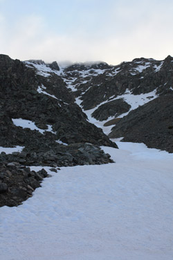 Cheyenne, good elevation, some really rugged terrain, more or less all season access, and enough easy 14'ers to keep the Cottoneers away from the 13'ers. I've had my sights set on the west face of Mt. Democrat for a long time but instead, I cut a mile off the approach and decided the couloir on Traver would be the route. Cheyenne, good elevation, some really rugged terrain, more or less all season access, and enough easy 14'ers to keep the Cottoneers away from the 13'ers. I've had my sights set on the west face of Mt. Democrat for a long time but instead, I cut a mile off the approach and decided the couloir on Traver would be the route.
We left Cheyenne on time and hit drizzle by the time we got to Longmont, rain by Denver and it was still raining as we climbed toward the tunnel on I-70. This was not in the forecast and I really didn't want to do a spring snow climb in the rain. Well, actually, a spring snow climb in the rain was a no go for all of the obvious snow stability reasons. This was looking to be one of those long drives for naught, but there was always the chance that the clouds and the precip were just piled against the Front Range and we would pop out of the tunnel onto a dry road, see stars in the sky and have a perfect frozen snow night. That is not quite what happened . . . the road was bone dry, the moon was somewhat visible through a slight haze while the temps were clearly borderline. I told Bob that if the conditions were not right, we'd just pick a hike/snowshoe route on another peak to salvage the day.
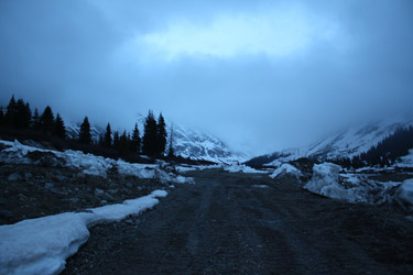
 We exited I-70 and climbed over Fremont Pass to the parking area at the hairpin turn below the Climax Mine. I'd never climbed from that trail head before and it was 04:45 dark when we got there. I hopped out of the truck to stomp a nearby snowbank . . . the old frozen or not frozen test . . . and found that the snow was not frozen at the trail head. Not a good sign. There was also a touch of a cold wet wind, so I figured ten more minutes in the truck would not hurt. I got warm, got on the climbing garb and then took another shot at starting this climb. The wind was now gone and the moon peeking through . . . just the glimmer of hope I needed to motivate me to get going. We debated whether to take the snow shoes or not, finally deciding to strap them onto the packs, just in case the snow on the valley floor was deep and soft. We exited I-70 and climbed over Fremont Pass to the parking area at the hairpin turn below the Climax Mine. I'd never climbed from that trail head before and it was 04:45 dark when we got there. I hopped out of the truck to stomp a nearby snowbank . . . the old frozen or not frozen test . . . and found that the snow was not frozen at the trail head. Not a good sign. There was also a touch of a cold wet wind, so I figured ten more minutes in the truck would not hurt. I got warm, got on the climbing garb and then took another shot at starting this climb. The wind was now gone and the moon peeking through . . . just the glimmer of hope I needed to motivate me to get going. We debated whether to take the snow shoes or not, finally deciding to strap them onto the packs, just in case the snow on the valley floor was deep and soft.
 The road you are supposed to take turns to the right in a another hair pin turn and appears to then cut back and track the west side of the valley. Well, I got my idiot card punched (again) by not looking closely at the topo map in the book and instead just went directly up the center of the valley. It was dark, there was an obvious gate, I'd not been there in summer, and I can still come up with a few more excuses given very little time. We ducked under the gate and bee lined up valley right into a snowy area obviously being reclaimed, hence lots of mud and water, and ice . . . and well a really lousy route. There was now enough light to see a bit and while I still could not pick out "the" road, I did spot some snow pushed up and knew that was the sign of a plowed course. We slogged over to a cat track and continued up valley along its course. The end result was that we now spotted the base of the couloir and pretty much straight lined it to the talus/snow fan at its base. Unfortunately, the cat track only went a hundred yards so the snowshoes came in very handy as we post holed our way through the deeper spots. The road you are supposed to take turns to the right in a another hair pin turn and appears to then cut back and track the west side of the valley. Well, I got my idiot card punched (again) by not looking closely at the topo map in the book and instead just went directly up the center of the valley. It was dark, there was an obvious gate, I'd not been there in summer, and I can still come up with a few more excuses given very little time. We ducked under the gate and bee lined up valley right into a snowy area obviously being reclaimed, hence lots of mud and water, and ice . . . and well a really lousy route. There was now enough light to see a bit and while I still could not pick out "the" road, I did spot some snow pushed up and knew that was the sign of a plowed course. We slogged over to a cat track and continued up valley along its course. The end result was that we now spotted the base of the couloir and pretty much straight lined it to the talus/snow fan at its base. Unfortunately, the cat track only went a hundred yards so the snowshoes came in very handy as we post holed our way through the deeper spots.
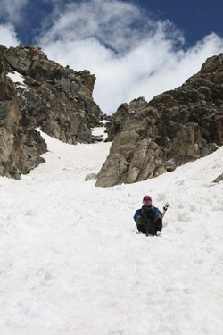
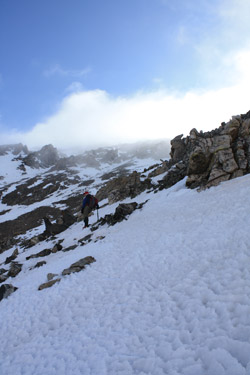 We arrived at the base of the climb and the question was of condition of the snow in the couloir. I saw no slide debris up through the route and the nearby snow in the cleft itself was frozen. We dropped the snowshoes and broke out the ice axes. The couloir was described as averaging 38 degrees and I'd peg that as accurate. We started up through the lower section, looking up to a rocky section that in our early morning, slope foreshortening minds, seemed to represent the top of the climb. Trust me, it doesn't. The snow was frozen but more than a bit rotten as well. We'd break through here and there, not into wet mush, but into unconsolidated crystals. Nothing was going anywhere but sometimes you got a step and sometimes the crampons held on the surface. Given the narrowing confines of the couloir, I had a hunch the snow would improve with elevation and shade from the previous day's sun. I was correct and by the time we reached the rock "Y", the snow was in much better shape. We arrived at the base of the climb and the question was of condition of the snow in the couloir. I saw no slide debris up through the route and the nearby snow in the cleft itself was frozen. We dropped the snowshoes and broke out the ice axes. The couloir was described as averaging 38 degrees and I'd peg that as accurate. We started up through the lower section, looking up to a rocky section that in our early morning, slope foreshortening minds, seemed to represent the top of the climb. Trust me, it doesn't. The snow was frozen but more than a bit rotten as well. We'd break through here and there, not into wet mush, but into unconsolidated crystals. Nothing was going anywhere but sometimes you got a step and sometimes the crampons held on the surface. Given the narrowing confines of the couloir, I had a hunch the snow would improve with elevation and shade from the previous day's sun. I was correct and by the time we reached the rock "Y", the snow was in much better shape.
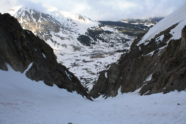
 The couloir appears to split about halfway up but, in hindsight, the "left" split is the climb and the "right" is an exit from the couloir. If you want to climb snow all the way to the summit area, go left, if the snow is no good and you want an exit onto class 2 rock adjacent to the snow, go right. This is hindsight, so we made our choice using a different guide, the right turn was clearly the steeper route and we were having a good climb, so we wanted to take the harder course. Bob kicked steps up the right course and we topped out on rock with the option to veer back toward the left and parallel the snow on upward. We climbed the easy but loose terrain and opted not to get back onto the snow as we had a good route and clear line. The "surprise" was that we were only a bit more than half way up the ascent and there was still a good bit of climbing to get to the top. The couloir appears to split about halfway up but, in hindsight, the "left" split is the climb and the "right" is an exit from the couloir. If you want to climb snow all the way to the summit area, go left, if the snow is no good and you want an exit onto class 2 rock adjacent to the snow, go right. This is hindsight, so we made our choice using a different guide, the right turn was clearly the steeper route and we were having a good climb, so we wanted to take the harder course. Bob kicked steps up the right course and we topped out on rock with the option to veer back toward the left and parallel the snow on upward. We climbed the easy but loose terrain and opted not to get back onto the snow as we had a good route and clear line. The "surprise" was that we were only a bit more than half way up the ascent and there was still a good bit of climbing to get to the top.
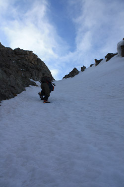
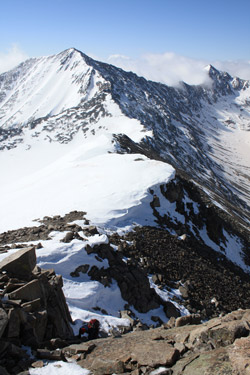
This approach to the summit proper of Traver can give you a nice section of class 3 climbing if you go for the summit block directly, perhaps 75 feet of vertical component (the route itself is not vertical). Once atop the ridge leading to the summit, we realized there was a class 2 snow walk around as well, but we had opted for the scramble. The scramble yielded a false summit from which we 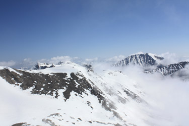 easily walked to the summit proper. We saw that the clouds of our drive in had bulled their way over the Front Range and were now butting up against the eastern flank of the Mosquitos. The valleys to the east were filled in by white and the ridge between Mts. Buckskin and Democrat were like a dam holding back a wall of white demanding access to the Arkansas valley. easily walked to the summit proper. We saw that the clouds of our drive in had bulled their way over the Front Range and were now butting up against the eastern flank of the Mosquitos. The valleys to the east were filled in by white and the ridge between Mts. Buckskin and Democrat were like a dam holding back a wall of white demanding access to the Arkansas valley.
With all the weather below us, the air on the summit was dead still, the sun was shining and one could not imagine a finer day in the mountains. We snacked, hydrated and I suggested to to Bob that we make the walk to McNamee and on over the Clinton Peak as well. The route looked tame and I did not figure the traverse would take that long. We hefted the packs and were soon off to score two additional summits. The walk off Traver was on good solid snow 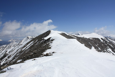 and the firm snow held for the whole of the traverse and return. We summitted McNamee perhaps 15 to 20 minutes later and looked down into the gaping open pit of the Climax Mine. As a Colorado Mines grad in Mining Engineering, I would love to have done a hitch in Leadville but the days of Mines and Amax being conjoined twins as to employing graduates had passed by the time I graduated in '84. Though no longer in the mining game, I am still fascinated by the scope of the operation. We moved off the summit of McNamee and walked the snow to the summit of Clinton Peak. The route was clearly corniced, as we saw from Traver, so we were pretty much walking at the rear rock/snow interface and steering clear of the edge that had already fallen away in a place or two. and the firm snow held for the whole of the traverse and return. We summitted McNamee perhaps 15 to 20 minutes later and looked down into the gaping open pit of the Climax Mine. As a Colorado Mines grad in Mining Engineering, I would love to have done a hitch in Leadville but the days of Mines and Amax being conjoined twins as to employing graduates had passed by the time I graduated in '84. Though no longer in the mining game, I am still fascinated by the scope of the operation. We moved off the summit of McNamee and walked the snow to the summit of Clinton Peak. The route was clearly corniced, as we saw from Traver, so we were pretty much walking at the rear rock/snow interface and steering clear of the edge that had already fallen away in a place or two.
 We rested a bit on the summit of Clinton but still .. . no wind and lots of sun. The clouds were lifting out of the eastern valleys so it was time to head on back to Traver and the truck. We reversed our course over McNamee and back to the saddle below the Traver summit. I'd scoped out the access to the upper reaches of the route down so we made a traverse over to intercept the descending snow field. We gained the snow, put our crampons back on, and once again stowed the hiking poles in favor of ice axes. The upper part of the snow was in fair shape but warming quickly. No dripping snowballs but I don't think the drippy aspect was more than an hour off. We found the center of the couloir was a post hole minefield, grabbing here and there and making for a miserable descent. The snow had gone to s%#t for sure. We passed through the center without delay but did gain better snow through the bottom third of the descent. Soon enough we were back at the stashed snow shoes and taking a break before heading for the truck. We rested a bit on the summit of Clinton but still .. . no wind and lots of sun. The clouds were lifting out of the eastern valleys so it was time to head on back to Traver and the truck. We reversed our course over McNamee and back to the saddle below the Traver summit. I'd scoped out the access to the upper reaches of the route down so we made a traverse over to intercept the descending snow field. We gained the snow, put our crampons back on, and once again stowed the hiking poles in favor of ice axes. The upper part of the snow was in fair shape but warming quickly. No dripping snowballs but I don't think the drippy aspect was more than an hour off. We found the center of the couloir was a post hole minefield, grabbing here and there and making for a miserable descent. The snow had gone to s%#t for sure. We passed through the center without delay but did gain better snow through the bottom third of the descent. Soon enough we were back at the stashed snow shoes and taking a break before heading for the truck.
 We reversed our course back to the truck, skipping the reclaim bog and using the cat track and later plowed road for all it was worth. We skirted the head frame quickly and without delay or inspection to avoid the consequences of being off route, though at the time, we did not know where, under the snow, the official route through the valley actually was. Not problem and no hassles as were were back at the car in no time and . . . lo and behold, there lay the proper route, clear as day, staring us in the eye, but for the fact that we completely missed it in the morning darkness. Our total climb took 9 hours, about 1 1/2 hours of which was taken by the effort to score the two additional 13'er summits. In hindsight, the snow at the start was not optimal and though not thawed, it really needed a good consolidating thaw and hard freeze to bring it back into crampon cruise condition. The delay to our descent, realized in gaining the two additional summits, translated into pushing the envelope as to warming snow. We were off before the drippy snowball point but not by much. Clearly, it would have been more appropriate to have skipped the additional summits and made an earlier descent on better snow. We reversed our course back to the truck, skipping the reclaim bog and using the cat track and later plowed road for all it was worth. We skirted the head frame quickly and without delay or inspection to avoid the consequences of being off route, though at the time, we did not know where, under the snow, the official route through the valley actually was. Not problem and no hassles as were were back at the car in no time and . . . lo and behold, there lay the proper route, clear as day, staring us in the eye, but for the fact that we completely missed it in the morning darkness. Our total climb took 9 hours, about 1 1/2 hours of which was taken by the effort to score the two additional 13'er summits. In hindsight, the snow at the start was not optimal and though not thawed, it really needed a good consolidating thaw and hard freeze to bring it back into crampon cruise condition. The delay to our descent, realized in gaining the two additional summits, translated into pushing the envelope as to warming snow. We were off before the drippy snowball point but not by much. Clearly, it would have been more appropriate to have skipped the additional summits and made an earlier descent on better snow.
Snowed out on the other side of the valley . . . Mts. Arkansas and Tweeto
|
