Mounts Lincoln, Cameron, & Bross
September, 1983 - Quartzville Creek Road
March 10, 2012 - Kite Lake
Mt. Lincoln was my 1st 14'er and 28 years later became my 101st 14'er summit. There were a lot of differences between those two climbs, the first climb being an unknowing Cottoneer's Fall day hike and the second being a bit more seasoned climber's solo winter climb.
September 1983 - the 1st 14'er . . .
Mount Lincoln was my first 14’er and I was not out to climb all of them at that point, in fact, I was just a tag along on someone else’s hike. Roger, Dan and I took off early from the School of Mines in Golden to check out Mount Lincoln in connection with a hypothetical mine design project Roger had selected as a senior project. Lincoln was seriously mined in the past century and we were headed there to scope out the remains of an aerial tramway that Roger was incorporating in his mine planning design project.
We found the Quartzville Creek trailhead and headed up. We were certified Cottoneers: a nice late start, jeans and tennis shoes, and sandwiches in a sack. We walked, and walked, and walked and were even passed by a haul truck that was involved in some mining effort near the top of the peak. We scoped out mine ruins along the way eventually made it to the top. We then wandered over to Cameron and then around the bowl to the wide flat summit of Mt. Bross, before heading down the flank of Bross to the Volkswagen “Thing” that I called transportation during my college years.
We then had two, maybe three, 14’ers under our belts and did not even know that nearby Democrat was a 14'er too.
March 2012 - the 101st 14'er . . .
 The weather forecast for Saturday was not bluebird, it was beyond bluebird . . . 30 degrees, no wind and sunny all day. I tried to get G to go out but he was martially arting and Robert had just gotten back from a business trip and needed some family time. I was going climbing, even if it meant a solo trip. The weather forecast for Saturday was not bluebird, it was beyond bluebird . . . 30 degrees, no wind and sunny all day. I tried to get G to go out but he was martially arting and Robert had just gotten back from a business trip and needed some family time. I was going climbing, even if it meant a solo trip.
I have no issues with solo climbs, in fact I have always enjoyed them I as I set my own pace, take photos and make it most of the way through a book on tape during the approach and retreat portions of the climb. I generally will pick a route that will have some climber traffic and sometimes I end up climbing with someone that I meet along the way. A winter climb of Mts. Lincoln and Bross fit the bill exactly.
 I beat the alarm and was out the door and southbound from Cheyenne at 3 a.m., headed for Fairplay. I knew it would be a fantastic ski weekend but figured I was still early enough to take I-70 in the morning, which was exactly the case . . . no traffic at all. I came to the end of the plowed section of road to Kite Lake at 6:30 and, after lending a couple of shovels to the two guys who were a bit over ambitious with their Jeep, I got my stuff to together for a 7 a.m. depart. I hefted my pack on time and headed up what I knew would be every bit of 3 to 3.5 miles of road before arriving at Kite Lake and the start of the real climb. Two months before, we had driven all the way to the end of the road but winter had to come eventually and as such, I put the ear buds in my ears for a long walk. I beat the alarm and was out the door and southbound from Cheyenne at 3 a.m., headed for Fairplay. I knew it would be a fantastic ski weekend but figured I was still early enough to take I-70 in the morning, which was exactly the case . . . no traffic at all. I came to the end of the plowed section of road to Kite Lake at 6:30 and, after lending a couple of shovels to the two guys who were a bit over ambitious with their Jeep, I got my stuff to together for a 7 a.m. depart. I hefted my pack on time and headed up what I knew would be every bit of 3 to 3.5 miles of road before arriving at Kite Lake and the start of the real climb. Two months before, we had driven all the way to the end of the road but winter had to come eventually and as such, I put the ear buds in my ears for a long walk.
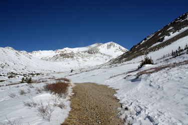
 The route alternated between snow and exposed road, the snow never being very deep and in almost all cases being wind hammered enough to avoid any postholing. I made Kite Lake after an hour and a half and took a short break to pick my route up Mts. Lincoln and Bross, or would it be vice versa? Rather than head for the Democrat/Cameron saddle, I picked the trail that heads for Bross right out of the campground. The route to the climb proper was mostly snow and again it was wind hammered enough that again there were no postholes to slow up my progress. I headed for the closer gully that has a trail on its SE flank but in lieu of taking the trail, I stayed on the snow that looked to fill the base of the gully. The snow took a nice step and was not steep enough to require me to break out he axe nor cause concern as to having anything move. The route alternated between snow and exposed road, the snow never being very deep and in almost all cases being wind hammered enough to avoid any postholing. I made Kite Lake after an hour and a half and took a short break to pick my route up Mts. Lincoln and Bross, or would it be vice versa? Rather than head for the Democrat/Cameron saddle, I picked the trail that heads for Bross right out of the campground. The route to the climb proper was mostly snow and again it was wind hammered enough that again there were no postholes to slow up my progress. I headed for the closer gully that has a trail on its SE flank but in lieu of taking the trail, I stayed on the snow that looked to fill the base of the gully. The snow took a nice step and was not steep enough to require me to break out he axe nor cause concern as to having anything move.
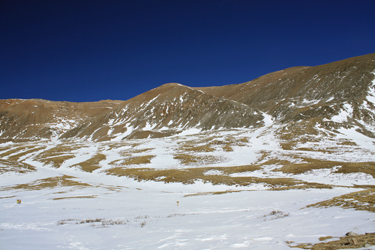
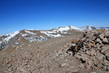
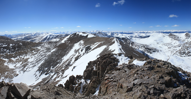
 I elected not to take the gully proper but instead a snowfield that led up the NW crest, a route that would provide easy footing on snow or alternatively a summer trail that from a distance could be seen to snake its way upward. I was not interested in a scree climb so I really had my eye on the scree/snow interface as easy terrain to climb. About 1/3 of the way up, the snow became less attractive than the now solid climber's trail, so I opted for the dry ground and made my way along the ridge proper toward the summit. After what was becoming an endless slog, the slope broke and I found myself nearing the summit plateau for Mt. Bross. I worked my way up the lessening slope until I reached the rolling summit "flats" and discerned which of the piled stone windbreaks marked the summit of Mt. Bross. I stopped for just a minute or two on this, my 100th 14'er summit, took a few photos, and hefted the pack again to make the long hike over to Mt. Lincoln in the distance. I elected not to take the gully proper but instead a snowfield that led up the NW crest, a route that would provide easy footing on snow or alternatively a summer trail that from a distance could be seen to snake its way upward. I was not interested in a scree climb so I really had my eye on the scree/snow interface as easy terrain to climb. About 1/3 of the way up, the snow became less attractive than the now solid climber's trail, so I opted for the dry ground and made my way along the ridge proper toward the summit. After what was becoming an endless slog, the slope broke and I found myself nearing the summit plateau for Mt. Bross. I worked my way up the lessening slope until I reached the rolling summit "flats" and discerned which of the piled stone windbreaks marked the summit of Mt. Bross. I stopped for just a minute or two on this, my 100th 14'er summit, took a few photos, and hefted the pack again to make the long hike over to Mt. Lincoln in the distance.
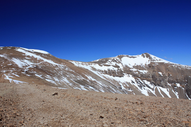
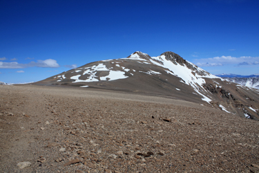 The route over to Mt. Lincoln is just a high traverse with enough distance and drop to allow Mts. Lincoln and Bross to be identified as separate 14'ers. But the two peaks are quite different in character, Bross being the flat rolling mound and Lincoln providing a bit of a ridge traverse before a short climb to the summit proper. I'd guess the distance to be a mile and half or so and the majority of the route was blown free of an significant snow. I hiked the old mining road from Bross toward Lincoln, skirting the summit of Cameron Pt. en route. The winds that had been at peace for the first part of the climb came up while I was crossing but they were to my back, so what the hey . . . The route over to Mt. Lincoln is just a high traverse with enough distance and drop to allow Mts. Lincoln and Bross to be identified as separate 14'ers. But the two peaks are quite different in character, Bross being the flat rolling mound and Lincoln providing a bit of a ridge traverse before a short climb to the summit proper. I'd guess the distance to be a mile and half or so and the majority of the route was blown free of an significant snow. I hiked the old mining road from Bross toward Lincoln, skirting the summit of Cameron Pt. en route. The winds that had been at peace for the first part of the climb came up while I was crossing but they were to my back, so what the hey . . .
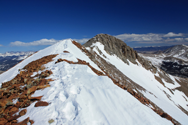 I climbed the first bump on the way to the summit of Lincoln and only then remembered the short stretch of ridge walk to the summit cone, which I climbed making use of a short snowfield and then the obvious summer trail to the top. The winds died off as I arrived, perhaps a bit of a thumbs up from Pachamama for returning to this place after so many years. I spent perhaps 5 minutes on top before heading for the truck a good six miles and three hours distant. I re-crossed the Lincoln Cameron saddle, skirting the top of Cameron once again and dropped off the Cameron/Bross saddle at the sign indicating the preferred route down. The route may be preferred but after dropping down a few old mine road switchbacks, the obvious course petered out for me and I took a series of fine heel kicking I climbed the first bump on the way to the summit of Lincoln and only then remembered the short stretch of ridge walk to the summit cone, which I climbed making use of a short snowfield and then the obvious summer trail to the top. The winds died off as I arrived, perhaps a bit of a thumbs up from Pachamama for returning to this place after so many years. I spent perhaps 5 minutes on top before heading for the truck a good six miles and three hours distant. I re-crossed the Lincoln Cameron saddle, skirting the top of Cameron once again and dropped off the Cameron/Bross saddle at the sign indicating the preferred route down. The route may be preferred but after dropping down a few old mine road switchbacks, the obvious course petered out for me and I took a series of fine heel kicking 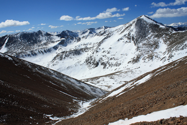 snow patches to drop elevation in a hurry. Again, not enough snow to cause worry as to movement but sufficient to allow a descent without messing about with the scree. The gully descent landed my right above Kite Lake and right back on the summer trail, albeit now a snow filled swale. snow patches to drop elevation in a hurry. Again, not enough snow to cause worry as to movement but sufficient to allow a descent without messing about with the scree. The gully descent landed my right above Kite Lake and right back on the summer trail, albeit now a snow filled swale.
I broke for a snack at one of the picnic tables at Kite Lake, the sky was blue without a cloud, the air was still and the sun felt great . . . winter climbing at its absolute best. After a drink, a Gu and some gorp, I had only to hike a bit over 3 miles of road to conclude the day's adventure. Each of the three miles proved a bit longer than the preceding one but after an hour and a half, I arrived back at the parking area, having covered about 12 miles over 9 hours.
|
