Vermilion Peak
North Ridge Variations - May 24, 2013 - Spring Snow
Two years before, Ed and I took a shot at Vermilion but scored Fuller instead. A pure and simple case of not reading the map we brought along and climbing what we thought was the right peak. Well, close made for a fun climb but not good enough to claim the summit of the Centennial that brought us to Ice Lake Basin.
 I'm not one to climb on Memorial Day but having finished the 14'ers and all of the Centennials within easy driving distance of the Front Range, I figured to combine one day of climbing with two days of wandering around the San Juans with my wife. We've got an arrangement where I pick a peak with trailhead camping, make an alpine start and then do things together for the rest of the weekend. I get a peak in and we get most of the weekend to hike, soak, 4WD or do whatever. This was one of those weekends. I'm not one to climb on Memorial Day but having finished the 14'ers and all of the Centennials within easy driving distance of the Front Range, I figured to combine one day of climbing with two days of wandering around the San Juans with my wife. We've got an arrangement where I pick a peak with trailhead camping, make an alpine start and then do things together for the rest of the weekend. I get a peak in and we get most of the weekend to hike, soak, 4WD or do whatever. This was one of those weekends.
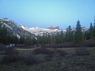
We left Wyoming on Friday morning and made good time en route to Mineral Creek Campground outside of Silverton. I did not know exactly when the jeep crowds descended on Ouray and Silverton but figured an earlier arrival was better than a 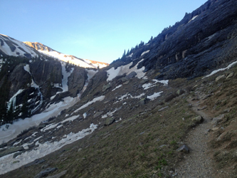 late one. We were pleasantly surprised to find not just a couple of open spaces but that there were no campers but for the campground host and one RV'er. We picked a shady spot and set up Chateau Xterra for the night. Once camp was set, we napped a bit and then went into Silverton for dinner before calling it a night. My alarm was set for 3:30 as a compromise between wanting to sleep in and knowing that what snow remained in the upper basin would start going to hell within the first hours of daylight. late one. We were pleasantly surprised to find not just a couple of open spaces but that there were no campers but for the campground host and one RV'er. We picked a shady spot and set up Chateau Xterra for the night. Once camp was set, we napped a bit and then went into Silverton for dinner before calling it a night. My alarm was set for 3:30 as a compromise between wanting to sleep in and knowing that what snow remained in the upper basin would start going to hell within the first hours of daylight.
The alarm went off, too soon as always, and I worked up the motivation to get on the trail. The gear was packed from the night before so I needed only to conclude the snowshoe debate. Take them or not? I knew from my prior trip 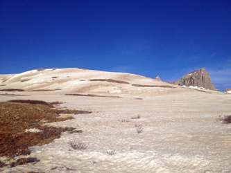 to Fuller that the snow would go to crap and if it was deep, I'd wish I had the shoes. But I was also three weeks later and there was much less snow . . . I figured the snow had been sun beaten and would be taking on some summer character. I knew the route to the peak and knew that I'd make good time over familiar territory. I also assumed I'd see no real snow until the upper basin, hence I elected to leave the shoes behind in favor of going light and fast. to Fuller that the snow would go to crap and if it was deep, I'd wish I had the shoes. But I was also three weeks later and there was much less snow . . . I figured the snow had been sun beaten and would be taking on some summer character. I knew the route to the peak and knew that I'd make good time over familiar territory. I also assumed I'd see no real snow until the upper basin, hence I elected to leave the shoes behind in favor of going light and fast.
Rather than take the trail directly out of the campground, I elected to walk back down the road and then cut up the 4WD road to Clear Lake as far as the first switchback, from which I could connect to the trail up Ice Lake Basin by means of a stub connector that crosses the creek on the remains of a log bridge. I knew there would be no 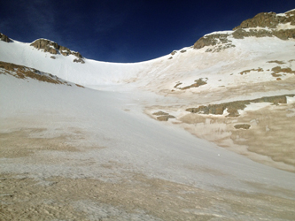 snow in the lower woods but with the melt going on in serious fashion, I had a hunch that the regular creek crossing could translate into wet feet so the road route seemed to be the better option. The half mile down the road and half mile up the side of the hill was quick and I soon left the road onto the short stub trail that leads to the creek crossing. snow in the lower woods but with the melt going on in serious fashion, I had a hunch that the regular creek crossing could translate into wet feet so the road route seemed to be the better option. The half mile down the road and half mile up the side of the hill was quick and I soon left the road onto the short stub trail that leads to the creek crossing.
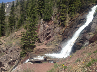
The creek was running nicely and the splatter from the upper falls had coated the entire log crossing with a layer of ice. Very nice, one slip and you get a ride down the side of the hill courtesy of the second falls. The answer here was putting on the crampons for a safe crossing and then stashing them again, not to be used for another couple of miles. With the creek crossing safely behind me, I made good time on the gentle trail leading to the 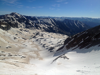 open patch of rock glacier that one crosses before taking on the headwall below the Lower Ice Lake Basin. On my prior climb of Fuller, we took the headwall on directly, climbing a snow slope that provided easy access to the Lower Basin. However this time I was on a clear trail and the route cut off into the woods to the far left of the headwall. open patch of rock glacier that one crosses before taking on the headwall below the Lower Ice Lake Basin. On my prior climb of Fuller, we took the headwall on directly, climbing a snow slope that provided easy access to the Lower Basin. However this time I was on a clear trail and the route cut off into the woods to the far left of the headwall.
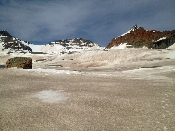
The trail entered the woods and soon enough provided hummocks of snow, not much but enough to have to climb over snow for 50 feet here and 75 feet there and generally being just about strong enough to support my weight, but only just about. Thankfully, the hummocks didn't last too long and after a half mile of winding about in the woods, I came to the top of the headwall and the anticipated stroll across the Lower Basin. Now I had 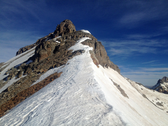 a clear dry hiking trail through the thinly wooded basin and around to a view of the next headwall. Like the lower headwall, we took this one on directly two years before, with an ice axe and snow shoe slog right up the middle. But not this time, as there was a clear trail that traversed the scree and talus bank below the wall and provided access to the next basin up. a clear dry hiking trail through the thinly wooded basin and around to a view of the next headwall. Like the lower headwall, we took this one on directly two years before, with an ice axe and snow shoe slog right up the middle. But not this time, as there was a clear trail that traversed the scree and talus bank below the wall and provided access to the next basin up.
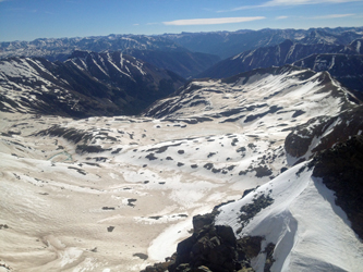
I crossed an intermediate creek, actually the lower reaches of the outfall from Ice Lake, and headed up the gentle traverse to a patch of lingering snow near the top. The snow was angled at 50 degrees and presented a 20 foot obstacle between me and the trail beyond. It was obvious ice axe and crampon territory but I opted instead to do the adjacent willow jungle gym challenge that over the 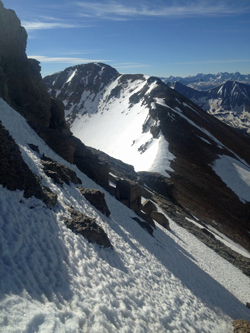 course of only 8 feet would get me past the obstacle. I think it came down to two evils and I chose the one that let me avoid getting gear out of the pack. Once back on dry trail, I traversed to the shallow basin that lies below the rocky hummocks that rise a couple hundred feet and denote the edge of the basin holding Fuller Lake. course of only 8 feet would get me past the obstacle. I think it came down to two evils and I chose the one that let me avoid getting gear out of the pack. Once back on dry trail, I traversed to the shallow basin that lies below the rocky hummocks that rise a couple hundred feet and denote the edge of the basin holding Fuller Lake.
Now faced with functionally continuous snow, it was time for the crampons. No axe yet, but the need for a bit of bite was obvious as the best route would be a direct move up slope on the still frozen snow. I donned the crampons, crossed one section of verglas covered rock and moved into the crampon cruise mode. Now it would be a case of one foot in front of another first up and over the hump to the Fuller Lake outfall and then across one more hump to the basin that lay below the face of Vermilion, Fuller and Golden Horn. From there I would move to the col dividing Fuller from Vermilion and then climb the Southeast Ridge of Vermilion to the summit proper.
 I crossed the basin below the snow slope and found the snow still frozen though the sun had been on it for no less than an hour by this point. No sign of recent avi action so I traversed back and forth across the wide couloir. The upper snow was beginning to soften and . . . it was only 8 in the morning. Clearly an early start was justified as I did not want to posthole my way out of the upper basin later in the morning. I made the top of the slope and broke out the axe for the single move up and over the 4 foot high vertical wall at the top. One easy move put me on the ridge proper and after a couple of Girl Scout Thin Mints ('tis the season . . . ), I was summit bound. I crossed the basin below the snow slope and found the snow still frozen though the sun had been on it for no less than an hour by this point. No sign of recent avi action so I traversed back and forth across the wide couloir. The upper snow was beginning to soften and . . . it was only 8 in the morning. Clearly an early start was justified as I did not want to posthole my way out of the upper basin later in the morning. I made the top of the slope and broke out the axe for the single move up and over the 4 foot high vertical wall at the top. One easy move put me on the ridge proper and after a couple of Girl Scout Thin Mints ('tis the season . . . ), I was summit bound.
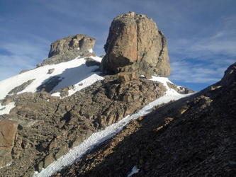
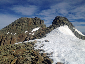 The ridge held a climber's trail that led the way for the first hundred yards before the snow on the backside of the peak covered it and necessitated a rising traverse across the hard snowfield for 100 yards and perhaps 100 vertical feet. This placed me at the first tower, that I cut around the base of on a wisp of a trail. The route then became unclear so I dropped down 30 feet or so, cut across a fin and then worked my way up the other side of the tower base, picking up a strong climber's track leading back to the ridgeline. The ridgeline offered a traverse to a view of the final rise to the summit and the impression of a jagged cleft separating me from that higher ground. The ridge held a climber's trail that led the way for the first hundred yards before the snow on the backside of the peak covered it and necessitated a rising traverse across the hard snowfield for 100 yards and perhaps 100 vertical feet. This placed me at the first tower, that I cut around the base of on a wisp of a trail. The route then became unclear so I dropped down 30 feet or so, cut across a fin and then worked my way up the other side of the tower base, picking up a strong climber's track leading back to the ridgeline. The ridgeline offered a traverse to a view of the final rise to the summit and the impression of a jagged cleft separating me from that higher ground.
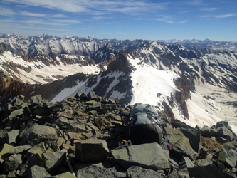 As is so often the case, the hardest looking pitch from a distance fades to an easy traverse once you turn the right corner. Corner turned, I simply crossed 15 more feet of flat snow and climbed the last 50 vertical to the summit proper. The summit is not large, more of the juncture of ridges, but it offer enough room to drop the pack and snap some photos before turning to make the climb back down. The summit also offers a view of the more technical Vermilion Dollar Couloir route as well as the difficult Northeast Ridge. Being solo, neither appealed to me as an ascent or descent route on this trip. I hefted the pack and returned the way I had come, leaving the summit at 9:05 or so and hoping that the snow below the col would not treat me to a festival of postholes. As is so often the case, the hardest looking pitch from a distance fades to an easy traverse once you turn the right corner. Corner turned, I simply crossed 15 more feet of flat snow and climbed the last 50 vertical to the summit proper. The summit is not large, more of the juncture of ridges, but it offer enough room to drop the pack and snap some photos before turning to make the climb back down. The summit also offers a view of the more technical Vermilion Dollar Couloir route as well as the difficult Northeast Ridge. Being solo, neither appealed to me as an ascent or descent route on this trip. I hefted the pack and returned the way I had come, leaving the summit at 9:05 or so and hoping that the snow below the col would not treat me to a festival of postholes.
 I made the drop off point and found good snow and heel plunged my way to the base of the slope in no time. I received Pachamama's favor in my descent but another hour and someone following me would have been taught the harsh lesson of a poorly chosen start time. The traverse across the high ground above Fuller Lake was mostly hard enough to cross but did offer a posthole here and there, just to remind me to make time and to teach me to stay in the center of the snowfield in order to avoid those shallow slushy edges. I crossed the Fuller Lake outfall and then dropped down the headwall leading to the top of the traversing trail and short snowfield that offered a lesson in willow grabs on the way up. I'd missed my ascent route but did find a few trail segments to signal that my bushwhack was not completely off the wall. I made the drop off point and found good snow and heel plunged my way to the base of the slope in no time. I received Pachamama's favor in my descent but another hour and someone following me would have been taught the harsh lesson of a poorly chosen start time. The traverse across the high ground above Fuller Lake was mostly hard enough to cross but did offer a posthole here and there, just to remind me to make time and to teach me to stay in the center of the snowfield in order to avoid those shallow slushy edges. I crossed the Fuller Lake outfall and then dropped down the headwall leading to the top of the traversing trail and short snowfield that offered a lesson in willow grabs on the way up. I'd missed my ascent route but did find a few trail segments to signal that my bushwhack was not completely off the wall.
 A short session with the willows next to the steep snowbank delivered me to the upward traversing trail and then onto the flats, signaling that the snowy portion of the climb was over with. I crossed the flats and dropped back into the woods, waging a brief encounter with a few of the hummocks, one of which laid me on my back for a nice 6 foot slide. perhaps the fatigue of the drive from Cheyenne the day before was telling . . . but I was soon up and moving across the rock glacier an then back through the wood to the falls crossing. The old logs were no longer icy but still a bit slick in a spot or two. I did not really want to put the crampons back on so a few well placed handfuls of gravel from the trail gave me the traction I needed for the one dicey footfall and then I was across. The road march fell into place and I was back at the truck in time for lunch . . . 4 a.m. start with a 12:15 finish. A short session with the willows next to the steep snowbank delivered me to the upward traversing trail and then onto the flats, signaling that the snowy portion of the climb was over with. I crossed the flats and dropped back into the woods, waging a brief encounter with a few of the hummocks, one of which laid me on my back for a nice 6 foot slide. perhaps the fatigue of the drive from Cheyenne the day before was telling . . . but I was soon up and moving across the rock glacier an then back through the wood to the falls crossing. The old logs were no longer icy but still a bit slick in a spot or two. I did not really want to put the crampons back on so a few well placed handfuls of gravel from the trail gave me the traction I needed for the one dicey footfall and then I was across. The road march fell into place and I was back at the truck in time for lunch . . . 4 a.m. start with a 12:15 finish.
|
