Rotator Placeholder Image
 
  • Mt. Bierstadt Group Summit - Front Range, Colorado
  • A rest before the summit push on Dallas Peak - San Juan Range, Colorado
  • Broken Ankle + 6 Miles = Tired
  • The classic San Juan approach - San Juan Range, Colorado
  • Overlooking Noname Basin from Twin Thumbs Pass - San Juan Range, Colorado
  • Upper Noname Basin - San Juan Range, Colorado
  • Nearing Noname Cabin - San Juan Range, Colorado
  • Twin Thumbs Twins - San Juan Range, Colorado
  • Nearing the summit of Pt. 13,736 - Sawatch Range, Colorado
  • Blustery day on Iowa Peak - Sawatch Range, Colorado
  • Morning snow at 15k, Cerro Ramada - Cordillera Ramada
  • Artesonraju from the summit of Nevado Pisco - Cordillera Blanca, Peru
  • February crowds on Gray's Peak - Front Range, Colorado
  • Kicking steps on Cerro Lliani - Cordillera Vilcanota, Peru
  • Final traverse to the summit of Wheeler Mountain - Ten Mile Range, Colorado
  • The long walk to Pachanta - Cordillera Vilcanota, Peru
  • banner31
    Afternoon at 17k on Cerro Ramada - Cordillera Ramada, Argentina
  • banner22
    The final ridge on Iowa Peak - Sawatch Range, Colorado
  • Summer summit on Longs Peak - Front Range, Colorado
  • A rest day at the Pachanta Hot Springs - Cordillera Vilcanota, Peru
  • Mind over matter on Mt. Parnassas - Front Range, Colorado
  • Rest stop on Cerro Lliani - Cordillera Vilcanota, Peru
  • banner30
    Post nap surprise on Cerro Ramada - Cordiller Ramada, Argentina
  • Summit on Cerro Lliani - Cordillera Vilcanota, Peru
  • banner23
    Ridge walking on Grizzly Peak - Sawatch Range, Colorado
  • Enroute the summit via the West Ridge on Pacific Peak - Ten Mile Range, Colorado
  • Mule train bound for Chilca - Cordillera Vilcanota, Peru
  • Taking in the view from Fletcher Peak - Ten Mile Range, Colorado
  • Hiking on Silverheels - Mosquito Range, Colorado
  • Traversing! Gladstone Peak - San Juan Range, Colorado
  • banner24
    The best of times at Willow Lake - Sangre de Christo Range, Colorado
  • banner29
    High Altitude Cerebral Edema? - Cordillera Ramada, Argentina
  • Bound for Chilca - Vilcanota Range, Peru
  • Going alpine light, Holy Cross Ridge - Sawatch Range, Colorado
  • Cumbre! Campa I - Cordillera Vilcanota, Peru
  • Roadside lunch with the best of company - Cordillera Vilcanota, Peru
  • banner25
    Long ridge walk to the summit of California Peak - Sangre de Christo Range, Colorado
  • banner28
    Crossing el Rio Colorado . . . in the afternoon - Cordillera Ramada, Argentina
  • banner37
    Dealing with Fall snows high on Casco Peak - Sawatch Range, Colorado
  • Moonrise over Mercedario - Cordillera Ramada, Argentina
  • Still climbing at 20,900 on Cerro Ramada - Cordiller Ramada, Argentina
  • Talus on Halo Ridge, Mt. of the Holy Cross - Sawatch Range, Colorado
  • banner26
    Deteriorating conditions on Mt. Arkansas - Ten Mile Range, Colorado
  • banner27
    After the climb - Cordillera Ramada, Argentina
  • banner38
    Taking in the view from the summit of Crystal Peak - Tenmile Range, Colorado
  • Topping out on Mt. Arkansas' North Couloir - Mosquito Range, Colorado
  • Glissade on Mt. Arkansas - Mosquito Range, Colorado
  • Hard snow morning on Teakettle Mountain - San Juan Range, Colorado
  • Spring snow announces the start of the climb on Dallas Peak - San Juan Range, Colorado
  • Crossing the Eolus Catwalk - San Juan Range, Colorado

2006 Apolobamba Expedition

Introduction

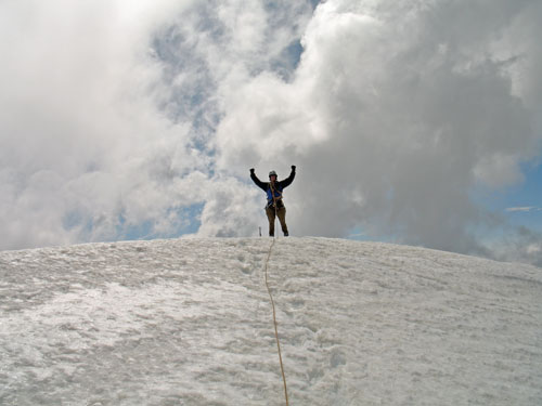
Our 2006 summer expedition took us to Bolivia's remote and somewhat uncharted Apolobamba range. The trip extended over two weeks and included three summits, Nevados Sunchulli and Posnanski, both located above Lago Kotani, and Cavayani, located in the Cuchillo/Sunchulli Pass region. Between climbs, we covered over 75 miles on foot and completed multiple reconnaissance hikes, simply to locate viable routes on these off the beaten path peaks.

Our Apolobamba Expedition report provides a narrative description of the trip on day by day basis and includes photos taken during the course of the trek, the recon hikes and all three summit climbs. In addition, there is discussion of our logistical arrangements to include lodging, camps, ground transportation, mules, and most of the other arrangements we required to get to and travel through the southern Apolobamba. I have also included a large list of GPS waypoints for the whole of the trek as well as the the individual climbs and "Google Earth" aerials with our camps and treking/climbing routes marked.

I will also take this opportunity to include a request . . . if you have Apolobamba information to share or corrections to any our our identifications, please don't hesitate to contact us. There is not a great deal of Apolobamba information available that pertains to the type of trip we took, i.e. a couple of guys pack their gear and go wandering about the Apolobamba in a merry mixed band of four people and three mules. Also, if you know of another site that should be included in my list of links, please let me know.

With that said . . . let me tell you the story of our expedition to the southern Apolobamba.