Ice Mountain & North Apostle
Ice Ascent via Refrigerator Couloir - Steep Snow
Ice Descent via Northeast Ridge
North Apostle via Southwest Ridge
Bob and I had not been out since our snow climb of Traver and Clinton Peaks back in May . . . therefore a climb was long overdue. I presented the idea of the Ice Mountain & North Apostle Combo, via the connecting saddle and Bob who had spent many a weekend in Winfield as a kid was up for a return to that old stomping ground. We left Cheyenne at 5:00 p.m. and after a stop for dinner 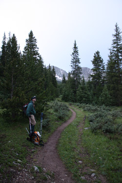 near Longmont, we were headed for Leadville and then on to a camp at the end of the 4WD road below the flank of Huron Peak. Things started to go south, literally, at Leadville when I stopped to get some breakfast fixings and found that what Safeway did carry was not in stock. I know . . . Leadville is Little Debbie Choco Cake country but I kind of gave that stuff up and there was nothing to be had that would not fit in a Climax lunch pail. I know, I worked underground for 6 years and had my fill of Choco Cakes. But we were just getting started on our southbound trip . . . near Longmont, we were headed for Leadville and then on to a camp at the end of the 4WD road below the flank of Huron Peak. Things started to go south, literally, at Leadville when I stopped to get some breakfast fixings and found that what Safeway did carry was not in stock. I know . . . Leadville is Little Debbie Choco Cake country but I kind of gave that stuff up and there was nothing to be had that would not fit in a Climax lunch pail. I know, I worked underground for 6 years and had my fill of Choco Cakes. But we were just getting started on our southbound trip . . .
We were turning onto the Chaffee County road to go to Winfield when I looked at the gas gauge and remembered that I wanted to fill up in Leadville. I wanted to fill up because I was going to be walking if I did not do so, hence the next task was a 180 degree turn and a half hour diversion back to Leadville to get gas and then back to the cut off to Winfield. I like my sleep and we had an alpine start planned so I just lost well over one half hour of my beauty sleep. The trip to Winfield was without hassle until we got to the four wheel drive portion of the road . . . that is when I remembered that I did not pack the tent poles for the tent we were going to 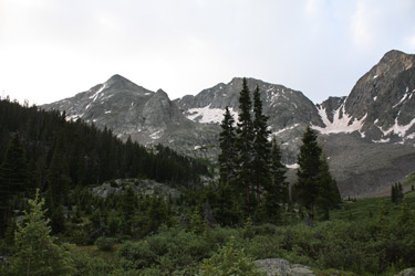 set up to stay dry while it rained that night. It is now II p.m. and I've managed to screw up breakfast, waste 45 minutes of good sleeping time and forget the poles for the tent, the only tent we brought. I'm 48 years old and I've been climbing and camping for 25 years and I still amaze myself at the degree of idiocy I am able to muster. set up to stay dry while it rained that night. It is now II p.m. and I've managed to screw up breakfast, waste 45 minutes of good sleeping time and forget the poles for the tent, the only tent we brought. I'm 48 years old and I've been climbing and camping for 25 years and I still amaze myself at the degree of idiocy I am able to muster.
We pulled to a flattish spot at the end of the 4WD road and I asked Bob if he was ready to set up the tent. He said he was so I told him that instead I would offer him an alternate challenge and that challenge would be to set it up without poles. He was not impressed but then I told him I had a plan . . . namely drape the tent fly over the bed of the truck after inflating the air mattress in the bed. I had a number of 20 foot long 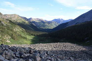 cinch straps so I knew we could lash up something when Bob suggested securing the fly to the cab and soon enough, we had a tent of sorts set up over the bed of the truck. Add a 6" thick air mattress and you have enough shelter to beat the rain until the planned alpine start. My alpine starts are usually on the order of 3 or 4 in the morning, especially when the rains have been beating up the mountains for about ten straight weekends but Bob and I said the hell with it and set the alarm for 4:30 a.m. cinch straps so I knew we could lash up something when Bob suggested securing the fly to the cab and soon enough, we had a tent of sorts set up over the bed of the truck. Add a 6" thick air mattress and you have enough shelter to beat the rain until the planned alpine start. My alpine starts are usually on the order of 3 or 4 in the morning, especially when the rains have been beating up the mountains for about ten straight weekends but Bob and I said the hell with it and set the alarm for 4:30 a.m.
As if we were expected guests, the rain began at about 4:00 and carried on steadily until just after we got up to the alarm. The tent fly truck bed 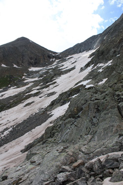 cover had done its job and we were still dry after five hours of fitful sleep. I just hoped that we could pull off a climb of at least one peak without an injury or some other finale fit for the debacle I seemed to be building for the record book. We got our stuff together and I dropped the PLB in the pack, why tempt fate, . . . and we were off at about 5:20. We had cover had done its job and we were still dry after five hours of fitful sleep. I just hoped that we could pull off a climb of at least one peak without an injury or some other finale fit for the debacle I seemed to be building for the record book. We got our stuff together and I dropped the PLB in the pack, why tempt fate, . . . and we were off at about 5:20. We had 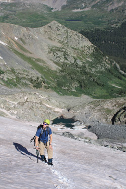 camped no more than 100 feet from the trail head gate so within just a minute we had the opportunity to get wet as we made our way through the willows that grow just on the far side of the gate. Once past the willows it was open trail, pretty much an old mining road to the old Hamilton town site, and we walked on steadily in the growing light. We had the headlamps on but did not need them after about the first 10 minutes. camped no more than 100 feet from the trail head gate so within just a minute we had the opportunity to get wet as we made our way through the willows that grow just on the far side of the gate. Once past the willows it was open trail, pretty much an old mining road to the old Hamilton town site, and we walked on steadily in the growing light. We had the headlamps on but did not need them after about the first 10 minutes.
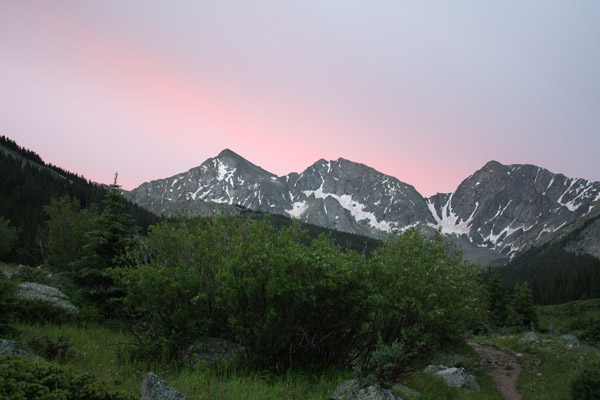
The day, however, was going to get better, much better and the first sign was that as we reached the Hamilton town site, we could see the Three Apostles with the most impressive alpenglow I've seen in my 25 years of climbing. A shimmering wave of pink draped atop these majestic peaks told us that perhaps, just perhaps, this day was going to be OK after all. I 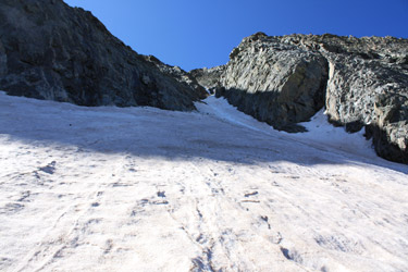 stopped to snap photos and this made for a good opportunity to take a sip and shoot a Goo in an attempt to ward off a lead weighted stomach, courtesy of my Safeway breakfast. We hefted the packs and moved on, soon arriving at the Apostles Basin trail juncture, which is well marked and obvious. We took the Apostle turn and I started counting steps, having read on Kane's Summit Post page that after 100 steps, there would be a cut off to the right which was the correct route. Kane described the route well and soon after step 100 (actually for me it came at step 170) there was the cut off, exactly as advertised. stopped to snap photos and this made for a good opportunity to take a sip and shoot a Goo in an attempt to ward off a lead weighted stomach, courtesy of my Safeway breakfast. We hefted the packs and moved on, soon arriving at the Apostles Basin trail juncture, which is well marked and obvious. We took the Apostle turn and I started counting steps, having read on Kane's Summit Post page that after 100 steps, there would be a cut off to the right which was the correct route. Kane described the route well and soon after step 100 (actually for me it came at step 170) there was the cut off, exactly as advertised.
 I knew we had to cut down to cross the creek on a large, but early morning wet, log and then climb up the finger of ground that divides the two streams that empty diverging valleys. The trail climbed steadily and the amount of wet weather we have been getting was obvious as the entire forest floor was green and the moss was hanging from the limbs of the pines. Not quite the southern spanish moss but you can get the idea without the chiggers. We went the next mile on the obvious trail until dumped into the northern terminus of a willow filled meadow, the Apostles Basin. I followed the trail across the grassy opening until it dropped to cross the creek and then rise on to the opposite bank before pulling only a semi successful disappearing act. The guides do not mention a trail at this point but in fact there is, for those with a bit of climbing experience, enough of a trace that you can cross to the eastern edge/flank of the basin and work your way along the edge without doing a willow bushwhack. I knew we had to cut down to cross the creek on a large, but early morning wet, log and then climb up the finger of ground that divides the two streams that empty diverging valleys. The trail climbed steadily and the amount of wet weather we have been getting was obvious as the entire forest floor was green and the moss was hanging from the limbs of the pines. Not quite the southern spanish moss but you can get the idea without the chiggers. We went the next mile on the obvious trail until dumped into the northern terminus of a willow filled meadow, the Apostles Basin. I followed the trail across the grassy opening until it dropped to cross the creek and then rise on to the opposite bank before pulling only a semi successful disappearing act. The guides do not mention a trail at this point but in fact there is, for those with a bit of climbing experience, enough of a trace that you can cross to the eastern edge/flank of the basin and work your way along the edge without doing a willow bushwhack.
 We made our way up basin until we had to cut around a rocky outcropping and make a decision as to our ascent up the wide couloir that leads to the saddle connecting North Apostle and Ice Mountain. I recalled that Roach took a route up the eastern side but at this point, my trail sense had failed me and I was not picking up an obvious flow of traffic. I'm really a boulder hopper at heart so we cut down and across a slight patch of willows and ascended the flank of the rock glacier and started making our way up the western approach to the couloir. My choice to go west was in part driven by the desire to avoid what looked like a tundra slope in favor of rock hopping and that I was unsure if there was some cliffing action just out of sight. Our We made our way up basin until we had to cut around a rocky outcropping and make a decision as to our ascent up the wide couloir that leads to the saddle connecting North Apostle and Ice Mountain. I recalled that Roach took a route up the eastern side but at this point, my trail sense had failed me and I was not picking up an obvious flow of traffic. I'm really a boulder hopper at heart so we cut down and across a slight patch of willows and ascended the flank of the rock glacier and started making our way up the western approach to the couloir. My choice to go west was in part driven by the desire to avoid what looked like a tundra slope in favor of rock hopping and that I was unsure if there was some cliffing action just out of sight. Our 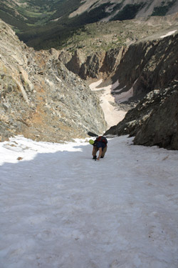 western approach offered a rounded headwall but also what I was pretty sure was a connecting ramp, so west we went. western approach offered a rounded headwall but also what I was pretty sure was a connecting ramp, so west we went.
The brief ascent up onto the rock glacier calls for a short but slightly exposed scramble up the toe of the rock glacier, which by its very definition lies at the angle of repose for the rocks, read really big rocks, at the top . . . just give them an excuse. Actually, I scoped left and right and noticed that other brave souls had the same idea and there was a route of sorts up the toe. Since there were no partial skeletons covered in rock, I gave it a shot and a few minutes later, Bob and I were on the top of the rock glacier and moving upward, one hop at a time. The course is a long sweeping ascent guided not only by the need to ascend but also by which immediate move will get you to the next balancing act, at an elevation slightly higher than the take off point. We hopped and hopped and hopped until we ran out of boulders and found ourselves climbing a slight snow slope to access the much smoother base of the mountain proper.
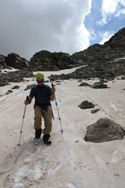
 This is where I figured to find a ramp that would lead up to the snow slope leading up the wide couloir and I was not too far off course. I'd guessed about 50 feet too low and when I tried to connect with the snow, I found that I needed to back track to gain some elevation and then we would be able to scramble along the smoother rolling terrain to connect with the snow. We had to cross a few snow slopes to get to our jumping off point but we had axes and the snow was just great for kicking a half to three quarter boot wide step for the crossing, albeit axe in hand. Bob took a bit higher route but we both arrived at the edge of the wide snowfield and neither of us had to lose a foot of elevation to get there. This is where I figured to find a ramp that would lead up to the snow slope leading up the wide couloir and I was not too far off course. I'd guessed about 50 feet too low and when I tried to connect with the snow, I found that I needed to back track to gain some elevation and then we would be able to scramble along the smoother rolling terrain to connect with the snow. We had to cross a few snow slopes to get to our jumping off point but we had axes and the snow was just great for kicking a half to three quarter boot wide step for the crossing, albeit axe in hand. Bob took a bit higher route but we both arrived at the edge of the wide snowfield and neither of us had to lose a foot of elevation to get there. 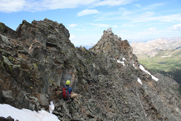 Well below us was the partially frozen lake held back by a portion of this headwall, not the place I needed to go in an uncontrolled slide. Well below us was the partially frozen lake held back by a portion of this headwall, not the place I needed to go in an uncontrolled slide.
We put on our crampons, stowed the hiking poles and I led off kicking an upward traversing route that would give us a climbing serpentine route to the saddle far above. I found the snowfield to be just plain typical, an early steep section that then mellows into a wider and more mildly angled climb. But it seems that the milder upper section is always about two or three times as far as I perceive it to be from the bottom. I ran into the same effect two months earlier on Uncompahgre and I just thought to myself, "boy this is going to be a trudge." Bob took a traverse or two to get his crampon 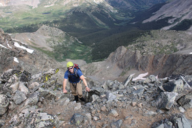 feet back after two months off but was soon close behind as I trudged up the upper section to the base of what I knew to be the Refrigerator Couloir, a steep snow route to the top of Ice Mountain that had been on my tick list for a season or two. But I also knew we were late in the snow season and at 9:30, late in the day from a snow climbing perspective. feet back after two months off but was soon close behind as I trudged up the upper section to the base of what I knew to be the Refrigerator Couloir, a steep snow route to the top of Ice Mountain that had been on my tick list for a season or two. But I also knew we were late in the snow season and at 9:30, late in the day from a snow climbing perspective.
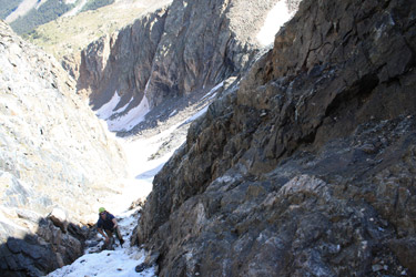
We climbed past the throat of the couloir, across rubble littered snow, to an area unpocked by the debris that obviously is shed by the upper slopes of Ice Mountain, down through the Refrigerator. I told Bob of the stories of engine block sized rocks coming down the cleft and the fact that the route was likely more than a bit dangerous track to the summit of Ice 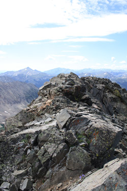 Mountain. But on the other hand, the snow was in great shape, the sun had not gotten to the couloir yet and Bob wanted to climb it. I gave it some thought, had not seen a rock yet, and we committed to a try, but not without the option to retreat if we found the upper reaches melted out, icy or otherwise not to our liking. I sure did not want a 2/3 climb followed by a retreat but I learned a long time ago that a pitch of class 5 climbing sans rock gear in crampons has enough pucker factor to last a lifetime and I still have enough a stash of old pucker to lend some to Bob if he needs it. Mountain. But on the other hand, the snow was in great shape, the sun had not gotten to the couloir yet and Bob wanted to climb it. I gave it some thought, had not seen a rock yet, and we committed to a try, but not without the option to retreat if we found the upper reaches melted out, icy or otherwise not to our liking. I sure did not want a 2/3 climb followed by a retreat but I learned a long time ago that a pitch of class 5 climbing sans rock gear in crampons has enough pucker factor to last a lifetime and I still have enough a stash of old pucker to lend some to Bob if he needs it.
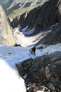
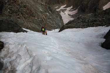
I noted to Bob that the center of the couloir was a deep runnel that seemed to give counsel and guidance to the rocks ejected out of the throat of the climb. I was not going near it and neither would he, instead I chose a flank route and crossed the runnel at the 1/3 mark where the couloir narrows and the runnel comes to an abrupt halt. We made steady progress and I found the going steep enough that I was most comfortable using the French technique with the axe in the self belay stance. The snow gave a full step but did not collapse under foot and it never gave me pause as to being too hard to 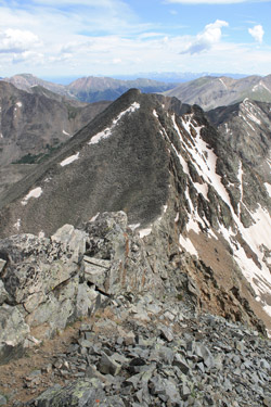 pull off an arrest or so soft that the snow and I would take a united slide. The steps were just plain sweet and Bob trudged along behind me, grinning from ear to ear. We arrived at the center section where the walls close and the route is but 6 or 8 feet wide. We were still on snow but the snow was obviously sitting atop a layer of alpine ice, exposed on both sides but well covered in the center three quarters of the width of the slot. pull off an arrest or so soft that the snow and I would take a united slide. The steps were just plain sweet and Bob trudged along behind me, grinning from ear to ear. We arrived at the center section where the walls close and the route is but 6 or 8 feet wide. We were still on snow but the snow was obviously sitting atop a layer of alpine ice, exposed on both sides but well covered in the center three quarters of the width of the slot.
We passed the constriction and then the slope opened up again but also got a bit steeper and I French footed my way to within 10 yards of the top, axe again in the self belay position for the entirety of the upper third of the climb. I must say this is one pretty piece of alpine real estate, steep snow, a touch of ice, and enough of a runout to remind you of why you got up at the early hour and why you just love this type of climbing. Now the down side, is that there is the better part of a 1500 foot runout and under the wrong conditions, this is not a route that will suffer fools well, if at all, should one screw up. We topped out and stepped lively off the snow to the left and found a spot to take off the 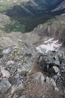 crampons. I quickly noticed the reason for the discharge of rock and debris down the couloir, the ground at the top is all loose, quite often angular and sharp . . . a wonderful source for the missiles that one must be on the look out for. Well, let's be honest, now that I've been to the top, if you climb this route you are really just playing the odds and hoping for the best. If you choose to climb behind another party, you are a fool, have stacked the odds against yourself, and you are hoping for the worst. crampons. I quickly noticed the reason for the discharge of rock and debris down the couloir, the ground at the top is all loose, quite often angular and sharp . . . a wonderful source for the missiles that one must be on the look out for. Well, let's be honest, now that I've been to the top, if you climb this route you are really just playing the odds and hoping for the best. If you choose to climb behind another party, you are a fool, have stacked the odds against yourself, and you are hoping for the worst.
The route from couloir exit is a five minute hand and foot class three scramble to the summit, which is a three way arret of sorts without the usual Sawatch flat spot. We set the packs down and took in the incredible scenery, not only of our lofty perch but also of the surrounding Collegiate Range, the Elks and a touch of San Juans were the visibility allowed. The clouds were starting to build but we'd gotten up the couloir in good time, landing on the summit at 10:20 or so, late by my standards but not inexcusably so. We were ready to move on after about ten minutes and though I did not know the route down to the Ice/North Apostle saddle, I knew 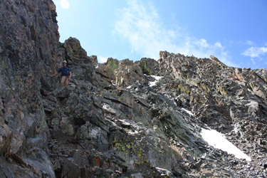 that to be the standard route, hence there would be enough foot traffic signs to allow one to pick one's way down the northwest Ridge with little difficulty. However, I say this with 80+ 14'ers under my belt, so what my be an obvious track across rock to me is, quite honestly, an indiscernible pattern to my wife on flat ground. that to be the standard route, hence there would be enough foot traffic signs to allow one to pick one's way down the northwest Ridge with little difficulty. However, I say this with 80+ 14'ers under my belt, so what my be an obvious track across rock to me is, quite honestly, an indiscernible pattern to my wife on flat ground.
I led off and picked my way down the ridge staying on the northern side of it for the whole of the descent, climbing carefully down the class 3 and 4 pitches that offer no forgiveness to carelessness climber. The route was quite exposed and we both made sure our hand holds were solid in this terrain that offers many a ready, but quite loose, point to grasp. I'd divide the descent into thirds, the first leg being class 4 and dropping perhaps 100 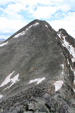 feet of vertical before depositing you at an obvious track that descends along a ramp like structure that yields perhaps another 100 feet. The excitement on the ramp came when Bob cut loose with a rock and I had to demonstrate the two handed wall grab and jumpwith the legs up in the air when the rock tumbles past. A neat trick that calls for the right hand holds, which I was fortunate to find just when I needed them. feet of vertical before depositing you at an obvious track that descends along a ramp like structure that yields perhaps another 100 feet. The excitement on the ramp came when Bob cut loose with a rock and I had to demonstrate the two handed wall grab and jumpwith the legs up in the air when the rock tumbles past. A neat trick that calls for the right hand holds, which I was fortunate to find just when I needed them.
The ramp seems to drop one into oblivion but instead of going down, I spotted the course climbing up and over another hump, after which it was another 100 feet of sinuous down climbing, not nearly as precipitous as the first segment. The last effort to gain the saddle comes in climbing up and over a class 2+ hump on the ridge to drop onto the saddle between Ice and North Apostle. The route up North Apostle is a herd path through a mix of scree and talus that, after 400 feet, granted us the summit of our second Centennial of the day. North Apostle offers the expected Sawatch summit, a rounded dome with room for the whole gang, and we took the opportunity to kill ten minutes on top before 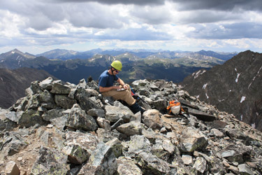 heading down. heading down.
The trip down to the saddle was a reversal of the ascent and then I just tracked the segmented and sometimes braided climber's trail to the base of the uppermost headwall in the broad couloir. We cut to descending climber's left, tapped into the upper most portion of the remaining snowfield and prepared to drop on down toward the lake far below. In the mean time, a solo climber was moving up the Refrigerator Couloir and within ten minutes the couloir coughed out the advertised engine block sized rock, which skidded and rolled about half way across the basin before coming to a stop in the soft snow. That settled our route selection task, we cut to climber's right, far to the right and  descended. We did stop and chat with an ascending climber and took his selection as to the route down the eastern flank of the gully, the opposite side from our ascent. In hindsight, neither side offers an easy descent as the descending right comes with lots of large talus and boulder hopping before you clear the couloir proper and surmount a gully or two before climbing down to the willows into the valley below. Lots of talus, lots of back and forth, and by the time I got to the upper most reach of the basin, my legs were half gelled. descended. We did stop and chat with an ascending climber and took his selection as to the route down the eastern flank of the gully, the opposite side from our ascent. In hindsight, neither side offers an easy descent as the descending right comes with lots of large talus and boulder hopping before you clear the couloir proper and surmount a gully or two before climbing down to the willows into the valley below. Lots of talus, lots of back and forth, and by the time I got to the upper most reach of the basin, my legs were half gelled.
 We skirted the edge of the rock glacier before cutting back to the side slope and working our way on down, effectively avoiding all but one patch of the pesky willows. I reminded Bob, as we pushed our way through the six foot deep sea of vegetative tendrils that this was nothing compared to the bad bush of "Nam". Not that I know bad bush from good bush, but I felt that I should make the remark, as I do every time we fight our way through a mass of willows. We traversed the edge of the basin and then I cut to the creek, hitting within 50 feet of the log crossing. From there it was just a matter of a two mile fast walk to the truck, where I disassembled the make do shelter as the Apostle basin disappeared into the most angry gray mass of cloud I've seen in a long time. The wind howled and without warning a 60 foot pine tree just 40 feet away snapped off four feet from the ground and nearly landed on the Toyota 4 Runner parked just down the road from us. Pachamama had spoken . . . so went left her to ruminate on her own. We skirted the edge of the rock glacier before cutting back to the side slope and working our way on down, effectively avoiding all but one patch of the pesky willows. I reminded Bob, as we pushed our way through the six foot deep sea of vegetative tendrils that this was nothing compared to the bad bush of "Nam". Not that I know bad bush from good bush, but I felt that I should make the remark, as I do every time we fight our way through a mass of willows. We traversed the edge of the basin and then I cut to the creek, hitting within 50 feet of the log crossing. From there it was just a matter of a two mile fast walk to the truck, where I disassembled the make do shelter as the Apostle basin disappeared into the most angry gray mass of cloud I've seen in a long time. The wind howled and without warning a 60 foot pine tree just 40 feet away snapped off four feet from the ground and nearly landed on the Toyota 4 Runner parked just down the road from us. Pachamama had spoken . . . so went left her to ruminate on her own.
|
