-
Mt. Bierstadt Group Summit - Front Range, Colorado
-
A rest before the summit push on Dallas Peak - San Juan Range, Colorado
-
Broken Ankle + 6 Miles = Tired
-
The classic San Juan approach - San Juan Range, Colorado
-
Overlooking Noname Basin from Twin Thumbs Pass - San Juan Range, Colorado
-
Upper Noname Basin - San Juan Range, Colorado
-
Nearing Noname Cabin - San Juan Range, Colorado
-
Twin Thumbs Twins - San Juan Range, Colorado
-
Nearing the summit of Pt. 13,736 - Sawatch Range, Colorado
-
Blustery day on Iowa Peak - Sawatch Range, Colorado
-
Morning snow at 15k, Cerro Ramada - Cordillera Ramada
-
Artesonraju from the summit of Nevado Pisco - Cordillera Blanca, Peru
-
February crowds on Gray's Peak - Front Range, Colorado
-
Kicking steps on Cerro Lliani - Cordillera Vilcanota, Peru
-
Final traverse to the summit of Wheeler Mountain - Ten Mile Range, Colorado
-
The long walk to Pachanta - Cordillera Vilcanota, Peru
- banner31
Afternoon at 17k on Cerro Ramada - Cordillera Ramada, Argentina
- banner22
The final ridge on Iowa Peak - Sawatch Range, Colorado
-
Summer summit on Longs Peak - Front Range, Colorado
-
A rest day at the Pachanta Hot Springs - Cordillera Vilcanota, Peru
-
Mind over matter on Mt. Parnassas - Front Range, Colorado
-
Rest stop on Cerro Lliani - Cordillera Vilcanota, Peru
- banner30
Post nap surprise on Cerro Ramada - Cordiller Ramada, Argentina
-
Summit on Cerro Lliani - Cordillera Vilcanota, Peru
- banner23
Ridge walking on Grizzly Peak - Sawatch Range, Colorado
-
Enroute the summit via the West Ridge on Pacific Peak - Ten Mile Range, Colorado
-
Mule train bound for Chilca - Cordillera Vilcanota, Peru
-
Taking in the view from Fletcher Peak - Ten Mile Range, Colorado
-
Hiking on Silverheels - Mosquito Range, Colorado
-
Traversing! Gladstone Peak - San Juan Range, Colorado
- banner24
The best of times at Willow Lake - Sangre de Christo Range, Colorado
- banner29
High Altitude Cerebral Edema? - Cordillera Ramada, Argentina
-
Bound for Chilca - Vilcanota Range, Peru
-
Going alpine light, Holy Cross Ridge - Sawatch Range, Colorado
-
Cumbre! Campa I - Cordillera Vilcanota, Peru
-
Roadside lunch with the best of company - Cordillera Vilcanota, Peru
- banner25
Long ridge walk to the summit of California Peak - Sangre de Christo Range, Colorado
- banner28
Crossing el Rio Colorado . . . in the afternoon - Cordillera Ramada, Argentina
- banner37
Dealing with Fall snows high on Casco Peak - Sawatch Range, Colorado
-
Moonrise over Mercedario - Cordillera Ramada, Argentina
-
Still climbing at 20,900 on Cerro Ramada - Cordiller Ramada, Argentina
-
Talus on Halo Ridge, Mt. of the Holy Cross - Sawatch Range, Colorado
- banner26
Deteriorating conditions on Mt. Arkansas - Ten Mile Range, Colorado
- banner27
After the climb - Cordillera Ramada, Argentina
- banner38
Taking in the view from the summit of Crystal Peak - Tenmile Range, Colorado
-
Topping out on Mt. Arkansas' North Couloir - Mosquito Range, Colorado
-
Glissade on Mt. Arkansas - Mosquito Range, Colorado
-
Hard snow morning on Teakettle Mountain - San Juan Range, Colorado
-
Spring snow announces the start of the climb on Dallas Peak - San Juan Range, Colorado
-
Crossing the Eolus Catwalk - San Juan Range, Colorado

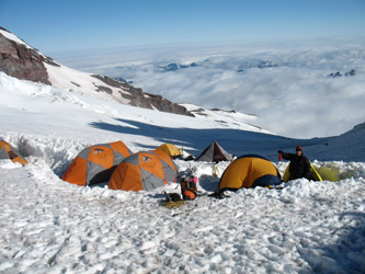 The guided teams were out of camp by midnight and we went back to sleep until the first light woke us to the sound of a strong wind sweeping across Camp Schurman. We again ate oatmeal and began the process of striking camp for the long walk back to the parking lot. The wind was coming up from the lower Winthrop glacier and the snow around the tents and camp was well frozen. The packs got heavy once again and we cramponed up for the walk down the Emmons to the Camp Curtis ridge and then on down the Interglacier to Glacier camp below. However, once we crossed the ridge on which the ranger hut sits, the sun had already begun working the snow and the Emmons decent was already mushing up at 8:00 in the morning. The crampons stayed on as there was a hard layer down a few inches but the snow conditions foretold what we had to look forward to later and lower along the descent.
 We took the long sweeping boot pack down the Emmons to navigate around the far end of the large crevasse that was just below the camp and then we made the short 200 foot climb back to solid ground just above Camp Curtis. It was time for the first gu stop/water break as the heat was on, at least for a few more minutes. The skies were, however not clear as we were going to drop into a cloud bank that filled the valley and started just a few hundred feet down the interglacier. The snow was really rotten by this point and I for one was hoping that the cloud cover might have forestalled the expected decrease in trail quality commensurate with losing elevation.
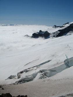 Initially I was disappointed as the footfalls went to mid shin, at best, and sometimes most of the way to the knee. This was not fun but every step was progress and we were at least going down hill. The fog came in and we lost sight of much beyond a hundred feet outside of our own little world but it did not last long enough to protect the snow and the post holing continued most of the way down the Interglacier. The clouds thinned and lifted as we neared the more gradual lower slopes and we could see multiple parties making their climb up and as Mr. T said in the A Team series, "I pity the poor fools" I would not have wanted to make the climb these groups were taking on as they literally slogged their way up what had become a mountain of mushy mashed potatoes, knee deep potatoes.
 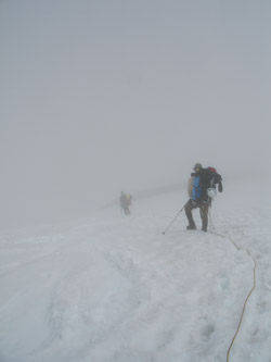 We took a breather on a rock outcrop at the bottom of the slope and packed the rope for the remainder of the trip out. The snow suddenly improved and within another 200 yards, we were stepping lightly on firm snow without breaking through. We kept going down and made the curve above Glacier Basin camp and walked along the stream until we had to cross to make our way down the steadily melting out trail. Just a few days had passed and the trail was continuing to melt out, enough that it at least seemed like there was less snow than when we climbed the same route 48 hours earlier. Regardless downhill progress can make many appearances more positive.
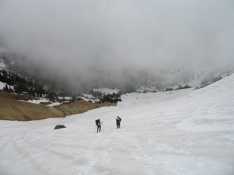 we knew that this point was just 1:15 uphill from the parking lot. The good trail segments came next and then we seemed to glide through the flood damaged sections with the same relative ease. Climb over a log here and there, side step through some brush but soon enough the last snowy stretch dropped us on the last paved campground loop, we were down.
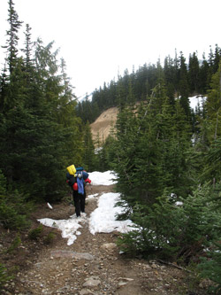 In hindsight, Rainier was no more difficult than any other glacier climb we had done in the past but one cannot forget that we had a great weather window and the advantage of coming to climb from living at elevation 6000 feet. I do not think we over estimated the climb as the approach was a tough 5000 feet and then the climb added another 5000 feet the very next day. We could have laid low for a day but we pulled off the two day climb without too much trouble. Of course, had the weather come in we could have had an epic but we were prepared for that occurrence. We did not have an abundance of food but we were otherwise clothed and geared for an extra stay or an overnight outside of the camp. We were prepared to wand the route at the slightest hint of trouble and in fact we took GPS locations and placed wands at the key junctures even though there was no hint of problem weather. We were also able to travel quickly due to past experience both as a rope team and experience on all the types of snow and ice we eventually climbed to reach the summit. All in all, a successful climb.