|
|---|
Notchtop MountainJune 7, 2008 - East Face Couloir (spring snow )
The operator of the guide service we used in Bolivia back in 2001 sat next to me in he airport in La Paz a few years later and we discussed how climbing gets tougher with age. He noted that in his opinion the first thing to go was perhaps not the body but instead "the alpine start" . . . and I'm afraid this trip showed our age. G and I needed a good full day out before the Rainier trip and we selected the East Face Couloir of Notchtop Mountain in Rocky Mountain National Park. We had looked at the route the year before when we climbed the flank of Halletts and then walked over to Ptarmigan Point to add some distance to the climb. We looked over the edge and noted the long finger of snow that dropped from the southern side of Notchtop's precipitous face to the valley far below.We took the drop to be 1500 to 2000 feet and figured that this would be a good climb for future Spring snow climb.
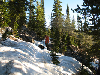
After climbing the far rock pile, we backtracked to Ptarmigan Point and then on over to the Flattop Mountain trail for our decent. The trail is gravel highway and we passed the exits for the Ptarmigan fingers, shot a photo or two of our completed route and headed on down the trail we had covered, perhaps too many times. The upper trail was windblown and clear but the lower section, in fact all of the section in the trees, was still snow covered and yes, it had gotten warm. Lots of slipping, sliding, and some post holing as we beat feet on down, making darn good time. I think we both really wanted off the now crappy low elevation snow and I know we both had food on the mind. We thankfully hit the clear trail and were back at the car at 2 p.m. We had a new route in hand, got in some good conditioning, and had talked our way through the final planning phase of the upcoming Rainier climb.
|

 We left my place at 3 a.m. after admitting the previous day that this would mean a departure from the trail head at about 5:30. That's late and we knew we were pushing the limit for the snow going to heck but since the forecast did not call for the temps to drop much below freezing, we figured we could just swap this route for a shaded course if the climbing window closed before we arrived. We indeed left the trail head at 5:30 and found that the first half mile or so of trail was clear but for a few snow hummocks. Beyond the juncture with the trail to Bierstadt Lake, the trail became wholly snow covered and the snow was hard enough that we did not posthole. We both had snow shoes on our packs as we did not anticipate a daytime high of 60 could do anything but make a return without the snow shoes a miserable experience.
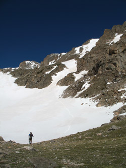 The approach to Lake Helene, where we would leave the rail and head for the base of the climb, was about 4.2 miles from the car. We had good daylight by the time we left the car so there was no route finding to speak of but even ff it had been dark we still would have followed the heavily skied and boot tracked trail to the lake. We arrived at the lake after about 2 hours, dropped the packs and took time for a drink and some food. We were carrying minimum water so the next stop was the outflow of the lake where we each pumped a quart of water for the climb up the couloir and on back down by whatever route we would later choose.
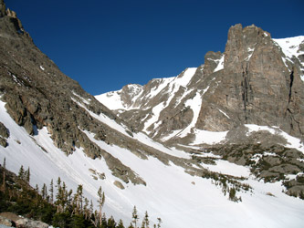
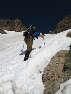 The valley below the flank of Notchtop has three lakes that are each perched at a different elevation, kind of a terraced affair. We stayed high and avoided dropping to the elevation of the upper most lake (the first one encountered) sticking to a route along the contact between the trees and the talus slope coming down the northern flank of Flattop. We managed to avoid most of the thickets of scrub pine but for two small stretches and were able to skirt across the snowfields forming the southern flank of the valley. The snow was softening underfoot but we were still not post holing, so all was well. We skirted the base of the cliffs and arrived at the tributary valley that cuts south to the Ptarmigan Fingers snow climbs and . . . the base of our planned climb as well.
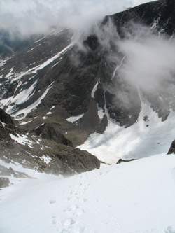 The route did not look that steep nor did it look that high. I got the sinking feeling we had walked five miles to walk up a softening 30 degree slope . . . well . . . I guess conditioning comes in all shapes and sizes . . . what the heck. We boulder hopped to the base of the couloir and stepped into the tracks of someone who has gone up earlier that morning (crampon front point marks still visible) and the snow was . . . not bad. It was 8:30 and it was not yet squeezably wet so we figured we'd climb the first 200 feet of vertical to a rock band that would let us see up the couloir and scope out any cornices that might threaten the route. We did the first few hundred feet, peeked around the corner and decided to climb onto a perch atop the rock band to break out an ice axe, stash a hiking pole and debate the need for crampons.
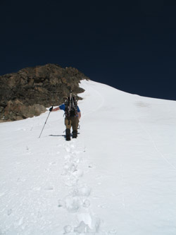 We nixed putting on crampons as the snow was yielding about a 4 to 6 inch footprint and the layer below was not stopping the axe shaft from getting good purchase. However, instead of going right up the center of the couloir, we cut diagonal to the sidewall to climb some steeper snow, perhaps up to 55 degrees then we climbed offset a few feet from the couloir edge through some crappy snow and saturated mud before getting back onto proper snow for the rest of the climb. G took the lead and kicked a good set of steps for another couple of hundred feet and then I took the lead again for the last couple of hundred feet.
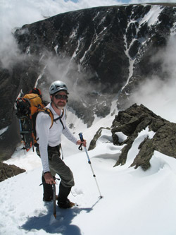 The last pitch (no protection just a lead change) was good sticky snow, the kind that molds around your boot and gives a solid step. Never a hint of an unstable layer, just good snow in the process of heating up and likely promising misbehavior later in the day. The angle steepened again and we enjoyed a good run of 50+ degree climbing until we reached nearly the top. The snow flattened out just below the top and G took over for the climb up and over the edge of the cornice that shadowed the path up the center of the couloir. We'd chosen a route to avoid its potential course and now needed only to pop over the top where the cornice smooths and transitions into the rock edge. Curiously, before the cornice was a small scale bergshrund where the snow was pulling away from the rock. G poked at the snow concealing the void and then elected to move left six feet and conclude the climb with ten feet of class 3 scramble. I followed.
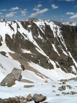 We topped out on the ridge that at some point is the "summit of Notchtop" assuming you are not an absolute purist and insist the the pinnacle portion of Notchtop is the true summit. It really did not matter to me as we came for the couloir and not the summit, should one become finnicky. We traversed north to the rock pile, perhaps one half mile away and climbed that as well. En route, we looked at the various other steep snow climbs that could bring one to the ridge, many of which had a decidedly technical character to them . . . food for thought next year.