|
||||||||||||||||||||||||||||||||||||
|---|---|---|---|---|---|---|---|---|---|---|---|---|---|---|---|---|---|---|---|---|---|---|---|---|---|---|---|---|---|---|---|---|---|---|---|---|
Sunlight Peak and Mount EolusJuly 15-18, 2002 - Red Couloir and North Ridge
Our recent trip to the Wilsons was a great success but the peaks of the Weminuche still remained to be climbed if I was to do my final two 14’ers. Due to forest fires, we had placed the train tickets in limbo and expected to use them some time next year. However, while looking at the Fourteener World forum, I noticed that the Durango and Silverton Railroad was again running trips through the Animas Canyon AND dropping hikers at Needleton. My wife and I looked at the reality of a climb next summer and came to the conclusion that the combination of an upcoming bar exam, an already planned vacation, and work demands would make taking a week to ride the train and climb an iffy proposition for 2003. So what do you do . . . turbo trip!
I called the railroad on the morning of the 15th and asked if a single spot was available for a Needleton drop off and found one for the next day. It is now 8 a.m. in Cheyenne and I headed for the garage to pack my gear, including the dreaded bigger pack needed for a multi night climbing trip. I knew I was short on time, with “in laws” and a sister headed to town for Frontier Days and a list of household tasks to be done before their arrival, but this was likely my last shot at finishing the 14’ers this year or even next. By ten, all the gear was packed and I was Durango bound.
Just south of Longmont, I came to the standard realization that I had forgotten something I would need but decided that I would just grab an extra at REI in Denver, where I planned to stop anyway. This is standard operating procedure for me at this point in my climbing career. When I was younger I would have used a pre-printed list of gear to ensure that nothing was forgotten but now that I’ve grown older and wiser, I don’t bother and take the lumps as they come . . . and they always come. I know I should know better, I’m an engineer for God’s sake, but workplace organization just doesn’t seem to always make it “out the gate.” I bought GU, a poly tee shirt and some hiking boot socks at REI and was once again enroute to Durango.
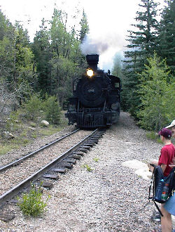
I arrived in Durango in the early evening and camped for the night at the United Campground, 4 miles north of town. This place has the best grassy tent area I’ve ever seen in a U.S. campground and if you need to overnight before or after, you will not find better. Due to the fires and the subsequent restrictions on the railroad, the Durango and Silverton was only running two trains to per day, a 9 a.m. and a second train, 45 minutes later. The later run would be the one to drop off hikers at Needleton, so I had time to do my grocery shopping the next day and then head for the railroad station to ditch my pack in the boxcar and await the start of the trip.
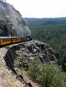
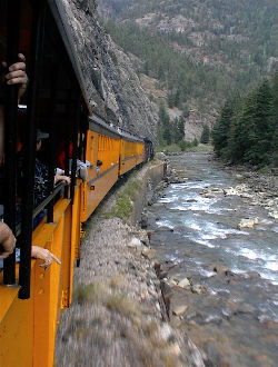
The first section pulled out on time and I made my way to a spot in one of the open cars to await the departure. I had hoped to snag a climbing partner for the two peaks, at the boxcar or trailhead, but I saw no signs of other climbers headed into the Weminuche. The trip up to Needleton is just an incredible train ride. Now realize of course, that I am a train fan and riding on a slow train to nowhere in a Central American country is my idea of fun, therefore I may be a bit biased. But one would have to be mightly cold hearted to not get a rush from taking a steam train up the Animas Canyon to start and later conclude a climbing trip. Two hours later, the conductor walked through the car and tapped me on the shoulder, saying to head for the front of the train as we were nearing Needleton.
The train pulled to a halt at the Needleton flag stop and before I got off, my bag was on the ground trackside. The conductor looked at me, noted aloud that it looked like a solo hike and for me to “be careful . . . we’ll see you in a few days.” I thanked him for the ride, hoisted my all to heavy pack and headed across the bridge over the Animas River. The first part of the slog to Chicago Basin is about a half mile walk along the river before encountering Needle Creek’s confluence with the Animas Rivers own path through the mountains. About 100 yards into the walk, the sky darkened and the first rain drops began to fall. I stopped, looked up, and asked myself just why I was standing here at the base of a 6 mile death march in the rain.
It was, of course, a bit late for questioning one’s motives, so I broke out the Gore-Tex outer shell and kept walking. I hit the canyon turn off and registered at the wilderness boundary, making a careful notation about peaks to be climbed, most likely camp spot, routes to be used, and timing. This was my second back-up as my wife had a detailed fact sheet, what we call the “where he at,” which I always leave with her in the event of a solo hike or climb. It provides exact route information, physical descriptions of gear, and the time at which I will call in and a time for her to call the Sheriff’s Department in event she does not hear from me. Though I am one to forget socks, I never skimp on the “where he at” and we have an ironclad agreement on the call time.
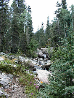
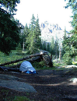
I walked the six miles to the upper basin in about 5 hours, taking my time and conserving energy for the next day’s climb. I maintained a leisurely pace, stopping to eat often and eating all along the way to keep the machinery going. Becoming overheated was not a worry, as the rain that started down below kept going all the way to the top, alternating between drizzle and full thunderstorm downpour. I was dry but the pack was wet and I was not looking forward to setting up a wet camp. My plan was to camp at around 11,200 feet and cut off as much of the approach to Sunlight and Eolus, in contrast to an earlier trip where we camped at about 10,500 and had an extra mile coming and going on our climb of Windom. I found a camp spot in some trees, above a meadow populated by four tents and 50 goats. Given the amount of horse manure on the trail up, I assumed someone had been packed in and there would be others in the upper basin. I was correct and found that a small suburb of Dallas had been relocated to the Chicago Basin for a Cottoneering convention or some similar climbing activity.
Dinner was over by eight and I settled into the tent for some sleep, though my first night on the ground is usually far removed from a decent night’s sleep at home. I set my alarm for 3:30 and wanted to hit the trail by 4 to beat out any repetition of the storms that had brewed by noon the previous day. I remembered that the climb up into the basin below Sunlight and Windom was a haul and an early start would not hurt, as I knew the route well enough to start in the dark. The alarm went off far too early and I lay there asking myself again why I was here and wouldn’t it be better to sleep in until 6 or 7? No, was my eventual answer and at 4 a.m. I was on the trail and heading toward the headwall that is the first obstacle to climbing Sunlight and Eolus.
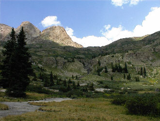
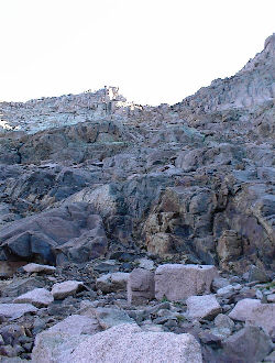
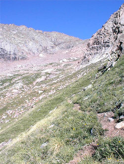
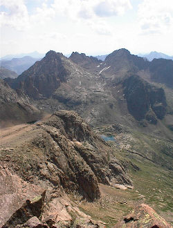
The trail up the headwall went quickly with a bit of a cool breeze that brought on a shiver or two. Rather than layer up, I elected to hike a touch on the cool side, knowing that the first hint of sun would eliminate any thoughts of another layer. I topped the headwall, passed the Twin Lakes, and climbed up and across the shoulder of rock needed to bypass the cliff bands that block a more direct route. The trail was well cairned to this point but I would guess that the “cairn building crew” were Windom climbers as there was little evidence of a concerted effort to mark a route up Sunlight. The route, for me, was plain to see and I headed up the combination of boulders and slabs to the base of the Red Couloir.
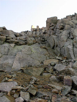
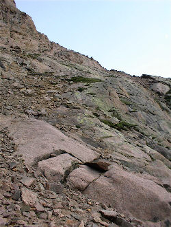
The climb of the couloir itself was not bad, just loose and braided with the trails of many who have chosen different paths through the scree filled gully. The route was not that steep and eventually I too reached the notch in the ridgeline separating Sunlight from the pinnacle laden ridge that includes Sunlight spire. I cut left and again followed a route marked not by cairns but by the wear on the lichens as I scrambled across boulders, working my way upward. The summit was not visible but again there was no lack of route, high on the boulders or lower on the scree, all of which continued to trend left until a short headwall was reached. I surmounted the headwall on the far right by dipping under a bridging slab, though there were other routes that would have attained the same goal, just with more exposure and challenge. I was solo and therefore stopping, assessing, and choosing the least exposed route in all cases.
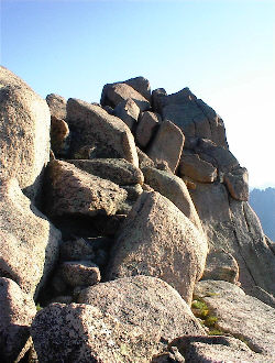
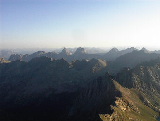
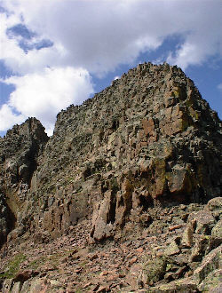
I reached the summit ridge and walked to the final move, which is more like a pile of four boulders than a single move to the top of one big rock. But, it is a move and a half, if you wish to stand on top of Sunlight Peak’s highest point. I did not make that move due to the exposure, my hand did rest on the high point, but I will admit that my feet did not. The guidebooks mention the consequences of a slip and they are dire. Since the USGS benchmark and the summit register are just below the top, I would certainly not give grief to anyone whose climb reached either of those two points of officialdom. The time was now 7:30 and the skies were clear of any clouds, a good day so far.
My next task was a safe descent from the boulder strewn summit and the Red Couloir below. I made good time down the gully and across the valley floor to the top of the headwall retaining the Twin Lakes. The time was now 9 a.m. and the skies remained clear . . . looked like an invitation to do Eolus to me. I stopped briefly to talk to some Cottoneer neighbors headed for what they thought was Windom and I took the opportunity to disappoint them with its true location, i.e. I let them look at my topo map, an essential that they, of course, had not brought along. I didn’t futz around with them for more than a few minutes before heading across the lake drainage to the obvious trail snaking up the basin nestled below the flank of Eolus.
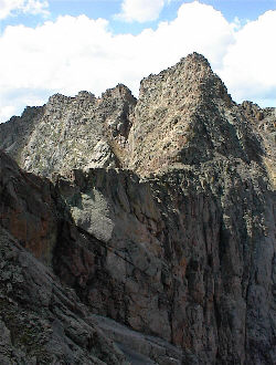
Eolus struck me as a peak whose personality is clearly split. The hike up the basin is as easy as climbing up Steven’s Gulch to do Gray’s Peak. I simply trod along the trail toward the cliff wall at the head of the basin, figuring that the trail would climb up an inclined bench to the ridgeline above. I was not disappointed and the trail simply goes to the cliff before cutting right to ascend to a wide saddle just below the Eolus ridgeline. I scrambled up to the ridge from there and wow, “what happened to the cakewalk?” The summit of Eolus is reached by crossing a saddle/ridge connecting the north and south highpoints of the peak. Since I was heading for the higher point on the south, I turned left and made my way across the ridge. The route is exposed and demands respect as a mis-step will likely conclude your climbing career.
I found that with the ridge behind me, the challenge of reaching the summit would increase and not slack with the hurdle of the ridge completed. I chose to ascend on the flank of the peak, following a cairned route that reminded me of ground leading to the summit of Capitol, loose rock, some braiding, and exposure to compound the climbing effort. The route was a typical combination of factors that alone were not that daunting, but the combination of loose ground and a not so obvious route, all perched atop the cliff band that defines the Eolus basin, made the final few hundred feet of vertical on Eolus as far cry from the easy strides required for the first 90% of the climb.
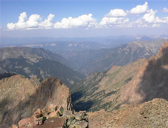
I reached the summit and stood atop my 54th 14’er. The clouds were building and I really had my mind more on a safe descent than any form of celebratory effort. I climbed Capitol with two fellows for whom that climb was their last 14’er and my reaction seemed to mirror theirs. I signed the register, drank some cytomax, shot a goo and took a few pictures. As is often the case, the route down was easier than the way up as I now had the perspective of being above the cairns and various routing selections. I was soon back at the summit side of the connecting ridge, with but one false turn in the process. I crossed the ridge again without incident, including the narrow section known as the “catwalk.” It was narrow but if I am right on my location, it was but a few steps in length. The rest of the ridge provided a comfortable three, four or more feet of width with solid holds where I needed them to climb over the miscellaneous blocks along the ridge top.
I came off the ridge and back onto the easy path, passing more neighbors on the way, each of whom was looking up and seeing a summit, while I looked up and saw building thunderheads. It was now 11 a.m. and they were headed for their first summit of the day as I expedited my departure from the heights below my second. I was not bugging out just to be off the peak, but I knew that the train to Durango would come through Needleton at 4:30 p.m. and if I could hustle, I would be homebound the next day and possibly avoid sitting through another afternoon of storms in the Basin and another at the flag stop the next afternoon. The route off Eolus was quick and I had but one stop to pump water as I had already been through 3 quarts. While filling my bottle, I also took a few moments to fill that of another neighbor, whose single bottle was down to a swallow and who literally had to be called over to get her bottle filled in lieu of a dry descent.
The camp came down quick, the only exception being the usual wrestling match I have with the sleeping pad. I love the way they self inflate but I would be willing to expend the lungpower to blow mine up if it would self deflate instead. With no small amount of time or effort, I won the battle with the pad and hefted the still all too heavy pack onto my shoulders for the hike to the Animas River far below. It was 1 p.m. and I had 3 ½ hours to cover the 6+ miles, all in a pair of new hiking boots for which this was the virgin trip. So far so good with the boots and I was liking them even more with every mile. The first mile was dry but after that, the thunderheads that were building around Eolus came to life, first with a bit of rain, then ½” hail which soon covered the trail for the next ½ mile. The hail melted away in the following downpour and then as I neared the valley floor, the skies grew less dark and the thunder stopped for my final mile. Needless to say, I was again dry but the pack was soaked and I was well into the tired mode. None too soon, the trail register appeared and I signed out and hustled along the river trail to the bridge across the Animas. I made the flagstop at 4 p.m. and within minutes the first train passed on its way to Durango. I was to flag the second section, so I had one half hour to wait, to hydrate, and eat some food before the train did indeed stop on my signal and haul my very tired body into town. It was a turbo trip if I’ve ever made one. When I left Cheyenne, I certainly did not expect to ride the train in on Tuesday morning and then ride it back out on Wednesday, having climbed both Sunlight and Eolus on that morning. I had a decent dinner Wednesday evening and by late Thursday afternoon, I was back in Cheyenne. |

