|
||||||||||||||
|---|---|---|---|---|---|---|---|---|---|---|---|---|---|---|
Blanca PeakApril 26-28, 2002 - Northwest Face and North Ridge
What fun would climbing be if everything went according to plan? Probably not much, we would all score a new summit on every trip, after a while, boredom would set in, and many of us would move on to some other entertainment. Trips such as our weekend in pursuit of Blanca and Little Bear provided the dose of adventure that turns a peak from a bagger’s target to a mountaineering accomplishment.
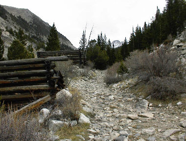
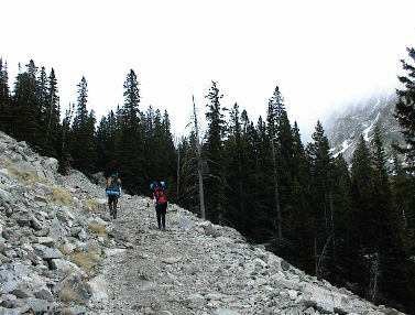
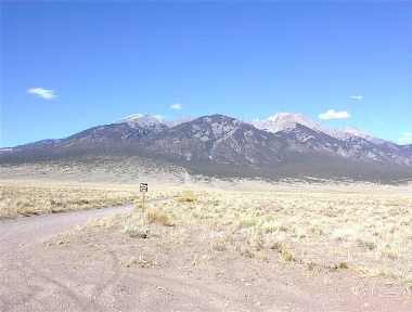
For any readers unfamiliar with climbing in the Sierra Blanca, the key to avoiding a long walk from the floor of the San Luis Valley (elevation 8000 feet) to base of most of the Sierra Blanca climbs is the Como Lake Road. Widely respected as one of Colorado’s toughest four wheel drive challenges, it is about 7 miles of terrain varying from sand to 3 and 4 foot ledges suitable only for a modified Jeep right off the Discovery channel. Fortunately, a stock Toyota Tacoma can take about 4.9 miles of the distance off the route if carefully driven. I am no expert at four-wheel drive but the fact that my Toyota is my only form of transportation ensures the “careful” element of the equation.
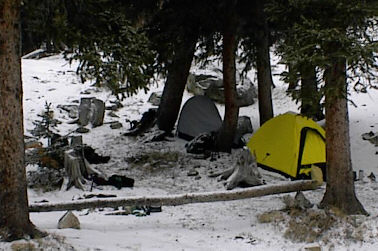
On the walk up, the wind had picked up a bit and a layer of cloud settled on the peaks at about the 13,500-foot level. Chilly gusts of wind would push us along on our trip up the road but we were content that the clouds would lift for the promised good weekend weather. Sometime around midnight, a rush of wind descended on our camp and built to a steady roar before being cut off in a flash of lightning and clap of thunder, at most one second later. Now bear in mind, we all live in Cheyenne and that means that a couple weeks of 50 mph winds is what we call normal. The storm lasted perhaps ten minutes before taking a half hour respite, and then the thunder and lightning came on again for round two. Of course, what fun is a storm without precipitation?
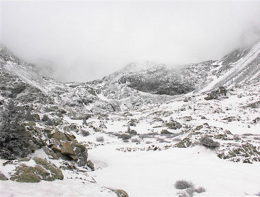
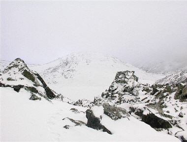
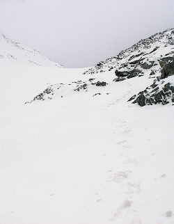
The year before, I climbed Ellingwood in May and I knew the basics of the route as I headed out under the beam of my headlamp. Gary and Diana did not have as far to go and got a later start at around 6:30, en route to the first couloir of Little Bear. The snow up through the woods on the far side of the lake was tracked but still solid and I was soon atop the first climbing segment and headed for the headwall beyond the Blue Lakes. The headwall can be passed on the right or left, however as I was a solo act, I skipped the right couloir route (a snow climb) in favor a linked summer trail segments on the left. Gary and I had agreed to “back at camp” times and I was determined to stick to snow routes that would provide a clear track of my route. I topped the headwall and moved on past a small lake, skirting it on the right side and crossing the hummock to descend toward the left side of Crater Lake. For readers not familiar with these climbs and planning to take a first shot in the spring, bear in mind the locales of these lakes and forget any thoughts of a quick didy-bop across those flat surfaces. I spotted more than one portion of soaked through snow and the unwary climber could find himself in real cold water without considering the hidden hazards of a winter lake traverse.
I made my way to the upper end of Crater Lake, all the time looking for a cairn to regain a traveled route through the “rock garden” in this portion of the valley. No such luck as the trail is off on the left side of the valley and I had long since missed whatever cut off may have been available. I looked at the rock in front of me and figured as long as it was traversable by snowfield, I would keep moving. I climbed a short rock pitch (six feet) and then weaved around the boulders and across hard snow to the flat ground just below the climb to ledgy section leading to the Ellingwood/Blanca saddle. This is also the point where the cloud cover and even more wind met the climber. I stopped to drink and found the back of my pack covered in rime ice and started doing the math. Lets see, as an engineer, I think the math goes like this: (Falling temperature) x (Solo travel) x (Decreasing visibility) x (Increasing wind) x (Not on trail) = Time to turn this climb and try another day. It was a good morning hike but I never did get to see Ellingwood, Blanca, or even their connecting saddle.
I headed back to camp and noticed another set of tracks on the road along the lake, toes pointing toward camp. Gary and Diana had similar luck but were also confounded by the lack of climbable snow. Gary and I had done Little Bear on snow last year and with the drought, figured the best shot at a repeat would be in April. No such luck, the couloir was filled with rock and knee deep facets. Trust me, when you want to snow climb Little Bear, facets are bad news and you might as well just cash the climb in at that point. Sure, it can be done, but did you drag those crampons along to slip and slide your way along when you should be cruisin’? We hit the tents for a nap and decided to re-assess the plan for the remainder of the weekend after a few hours. To stay for Sunday or not?
We overnighted in Alamosa and I ducked outside the motel at 4 a.m. to find a nearly full moon and still air. Against our natural inclination, we headed back to the Sierra Blanca and on up the Como Lake road, this time in the dark. Same parking spot, same drag ass hill to Como Lake (you darn right we did this one “alpine” style) and on up a route following the tracks of some fool who had been up there the day before. This time, however, Gary and I kept moving, up over the ledges, to the saddle and then on up Blanca’s ridge to the summit. The snow was sparse on the ridge but where found a snow segment; we took it (the snowfield above the ledges was 3 inches of powder on a hard spring base – glad I had the axe). Wind? You betcha . . . and we stayed away from that partially corniced edge of the ridge, it is one long way down. We wandered on back from the summit, crossing the lower snowfields, now bathed in some serious UV light (factor 30 x 2 applications = sunburn) and made the round trip in just a bit over 9 hours. Gary got a repeat and I picked up number 47 but Diana drew the miss card for the weekend. However, isn’t that part of this game? We miss and try again, the snow is good, the snow is bad, but we keep coming back?
|
