Pacaya Volcano
Tourist Hike to the Volcan Pacaya Lava Flow- March 15, 2009
Our day trip to Pacaya Volcano:
 While studying Spanish in Antigua, we could literally watch puffs of ash and smoke rise from the crater of Volcan Fuego so it is no wonder that Volcan Pacaya, southeast of Guatemala City is active to the point that you can hike to an incandescent lava flow, like right next to the lava as it flows in a stream down the the flank of the volcano. Arranging a trip to Pacaya is as easy as finding an Agente de Viajes on the main square in Antigua and paying your $8 for the bus ride to and from the trailhead. I acknowledge these are commerical tours with a group of 8 or 10 folks and it is a bit of a herd scenario but having done it, I'll admit to having a good time. I also think that, if you are based in Antigua, you could easily arrange a private trip with one of the travel operators and finagle a guide once you arrive at trailhead . . . there does not seem to be a guide shortage. The guides we had were radio equipped as security still appears to be a concern on Pacaya, as in past years. While studying Spanish in Antigua, we could literally watch puffs of ash and smoke rise from the crater of Volcan Fuego so it is no wonder that Volcan Pacaya, southeast of Guatemala City is active to the point that you can hike to an incandescent lava flow, like right next to the lava as it flows in a stream down the the flank of the volcano. Arranging a trip to Pacaya is as easy as finding an Agente de Viajes on the main square in Antigua and paying your $8 for the bus ride to and from the trailhead. I acknowledge these are commerical tours with a group of 8 or 10 folks and it is a bit of a herd scenario but having done it, I'll admit to having a good time. I also think that, if you are based in Antigua, you could easily arrange a private trip with one of the travel operators and finagle a guide once you arrive at trailhead . . . there does not seem to be a guide shortage. The guides we had were radio equipped as security still appears to be a concern on Pacaya, as in past years.
We paid our $8 for the trip, pocketed an extra Q40 for the park entry fee and were off on Saturday afternoon for the late afternoon/evening lava hike. The minibus picked us up in the central square in Antigua and I nabbed the "teniente" spot ("shotgun") so I could shoot picures through the front window. The bus made a circuit through Antigua picking up various tour participants at their hotels and hostels before wending its way up and over the the hills surrounding Antigua and dropping down toward Guate proper. We turned south before Guate and drove good roads all the way to the cut off that leads up to the volcano, its surrounding park, and neighboring communities. The van threaded its way through various small communities and climbed steadily along the forested slopes of the mountain. We passed an older lava flow that had made it to the road but did not stop there as we were enroute to the official trailhead, located in a small village near to a geothermal power plant.
 The van pulls in and as soon as you get out, you are swarmed by the local hiking stick vendors, all of whom are about 5 to 8 years of age. That hiking stick is a darn good idea and the price to "purchase" one is Q3 to Q5 each. Bargaining is part of the game but I sure didn't bargain with any gusto against a seasoned 6 year old. Two sticks for Q8, not a bad deal. Needless to say, if you visit Pacaya in this manner, get the stick, you'll be happy you did. A local guide then gathers your group together, assigns you an easy to remember group moniker . . . "Oso", "Pantera", "Tigre" . . . a good he man hombre name that they can holler out later to re-gather the group post lava when it is time to hike back to the trailhead. Sticks in hand, we were off to see the lava. The van pulls in and as soon as you get out, you are swarmed by the local hiking stick vendors, all of whom are about 5 to 8 years of age. That hiking stick is a darn good idea and the price to "purchase" one is Q3 to Q5 each. Bargaining is part of the game but I sure didn't bargain with any gusto against a seasoned 6 year old. Two sticks for Q8, not a bad deal. Needless to say, if you visit Pacaya in this manner, get the stick, you'll be happy you did. A local guide then gathers your group together, assigns you an easy to remember group moniker . . . "Oso", "Pantera", "Tigre" . . . a good he man hombre name that they can holler out later to re-gather the group post lava when it is time to hike back to the trailhead. Sticks in hand, we were off to see the lava.
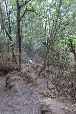
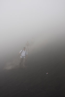
 These groups will by their very nature be of a heterogenous sort and if you are in reasonable shape you need not worry about holding the group back. The guides are also not going to leave anyone behind and are pretty consistent head counters. We started up the steep stone path that, after perhaps a quarter mile leads to a junction, afterwich the trail briefly drops before starting the real climbing portion of the ascent. The trail climbs up through a tangled forest area where the path is cut deeply into the ash of the last major explosive eruption, a blow that we were told sent ash as far south as El Salvador. The hiking at this point is steep but just keep up the trudge as this portion of the route is the crux of the climb for sure. Once atop the incised switchbacks the trail mellows and then turns right to continue as a more gentle ascent along the flank of the hill until the path intersects a road and old concrete structure. Our group stopped at this point to allow the tail end Charlies to catch up. At this point on our climb, the top of the volcano was socked in by a thick fog, These groups will by their very nature be of a heterogenous sort and if you are in reasonable shape you need not worry about holding the group back. The guides are also not going to leave anyone behind and are pretty consistent head counters. We started up the steep stone path that, after perhaps a quarter mile leads to a junction, afterwich the trail briefly drops before starting the real climbing portion of the ascent. The trail climbs up through a tangled forest area where the path is cut deeply into the ash of the last major explosive eruption, a blow that we were told sent ash as far south as El Salvador. The hiking at this point is steep but just keep up the trudge as this portion of the route is the crux of the climb for sure. Once atop the incised switchbacks the trail mellows and then turns right to continue as a more gentle ascent along the flank of the hill until the path intersects a road and old concrete structure. Our group stopped at this point to allow the tail end Charlies to catch up. At this point on our climb, the top of the volcano was socked in by a thick fog, 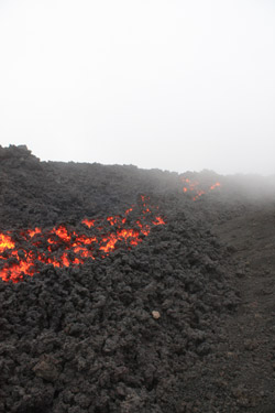 cutting the visibility to perhaps a hundred feet at best. It was late in the afternoon and it was obvious that we were not going to be afforded great views of the surround terrain. cutting the visibility to perhaps a hundred feet at best. It was late in the afternoon and it was obvious that we were not going to be afforded great views of the surround terrain.
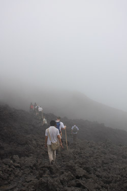
Our group, the "Osos" came together again and off we went through the fog on a footpath curving again along the flank of the peak but now above any vegetation and clearly on more recently created volcanic terrain. Bear in mind, this is not a trip through pristine forest but a path that passes power poles, old concrete pylons and the shells of decaying concrete structures no longer serving their intended purpose. We re-joined the road and again gathered at a point just above an ash bank that we would descend to the most recent lava flow, perhaps 100 feet below. We stood there in the fog, hearing voices below but seeing nothing but a wall of fog. Then, we all stepped off the trail and followed the lead of others scree skiing down through foot deep ash to what we could not see or otherwise discern. But, after a good ski, we all landed on a more recent flow and took time to . . . yes . . . re-group and more importantly empty our shoes of the ash that would remain resident for weeks to come and preclude white socks remaining white for a very long time.
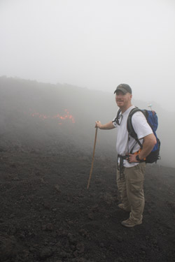
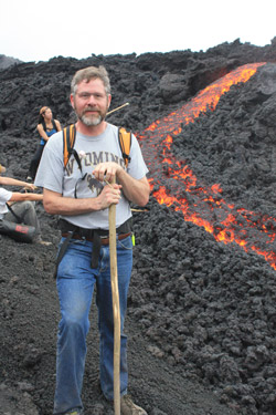
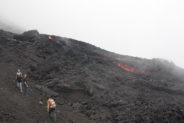 Once the shoes were emptied, the guide explained that the flow we were on was but a few years old and that we would hike across it to the present flow, just a 15 minute walk away. We hiked along the trail past lava pillars and cavities formed as the viscous lava flowed down this flank of the volcano. We came to another ashy area and then, through the fog, we spotted an incandescent glow ahead of us. A brief touch of the lava flow next to the trail showed that it was still hot to the touch and our guide explained that the adjacent lava was but 24 hours old and that the glow just ahead was today's lava actively flowing alongside the trail. Sure enough, 5 minutes later, there was indeed a six foot wide river of lava flowing but 6 feet Once the shoes were emptied, the guide explained that the flow we were on was but a few years old and that we would hike across it to the present flow, just a 15 minute walk away. We hiked along the trail past lava pillars and cavities formed as the viscous lava flowed down this flank of the volcano. We came to another ashy area and then, through the fog, we spotted an incandescent glow ahead of us. A brief touch of the lava flow next to the trail showed that it was still hot to the touch and our guide explained that the adjacent lava was but 24 hours old and that the glow just ahead was today's lava actively flowing alongside the trail. Sure enough, 5 minutes later, there was indeed a six foot wide river of lava flowing but 6 feet 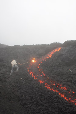 from the trail. It was not flowing quickly, perhaps 30 feet per minute, but it was a steady six foot wide river of molten rock, headed down hill. from the trail. It was not flowing quickly, perhaps 30 feet per minute, but it was a steady six foot wide river of molten rock, headed down hill.
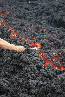
We climbed a bit further until we reached an ash bank abutting the lava from which you could see more lava above and discern the course of the red hot river as it snaked its way down through past flows, finding a course that would do for now but undoubtably change within the day. We toasted the obligatory marshmallows over the lava, which incidentally was also hot enough to roast the hair off your hand while you are pulling this tourist stunt. But what the heck, you don't get to be a doofus tourist like this very often and its just plain fun too. We never got to see any real view of the surrounding terrain, due to the fog that limited visibilty to a few hundred feet at best, and never did we see any sign of a summit cone or crater proper. After watching the flow for 20 minutes or so, grabbing a bite to eat from the pack, and taking lots of pictures, we Osos re-formed and began the trek back to the trailhead, about a mile and a half distant.
 We traced our route back through the older lava to the base of the ash ski slope. I was dreading the climb back up that slope but such is not the case as there was a trail that skirted the base to a bit of solid ground, obviating the need for what would have been a short but tough slog up the ash bank. We gathered again at one of the concrete building shells and then skirted along the back slope of the mountain to the top of the switchback section of trail. The sun was now just about down and by the time our group was about half way down the switchbaks, G and I broke out our headlamps to make the descent easier for us and possible for some of the folks less used to hiking. Word to the wise, bring a flashlight or headlamp if you do the afteroon hike, you'll be very glad you did. The fog stuck with us to the cow pasture before releasing its grasp and turning us over to night proper. We arrived at the last junction and dropped down the cobbled trail to the trailhead whereupon the gang of stick sellers were ensuring that anyone still bearing a stick (not otherwise burned in the lava) was quickly relieved of that stick to facilitate its prompt resale the next morning. We traced our route back through the older lava to the base of the ash ski slope. I was dreading the climb back up that slope but such is not the case as there was a trail that skirted the base to a bit of solid ground, obviating the need for what would have been a short but tough slog up the ash bank. We gathered again at one of the concrete building shells and then skirted along the back slope of the mountain to the top of the switchback section of trail. The sun was now just about down and by the time our group was about half way down the switchbaks, G and I broke out our headlamps to make the descent easier for us and possible for some of the folks less used to hiking. Word to the wise, bring a flashlight or headlamp if you do the afteroon hike, you'll be very glad you did. The fog stuck with us to the cow pasture before releasing its grasp and turning us over to night proper. We arrived at the last junction and dropped down the cobbled trail to the trailhead whereupon the gang of stick sellers were ensuring that anyone still bearing a stick (not otherwise burned in the lava) was quickly relieved of that stick to facilitate its prompt resale the next morning.
 The trailhead is replete with an open air tienda that sells the Central American trailhead standards, ranging from cola to beer and crackers to pork rinds . . . don't worry about end of the hike hunger. We all piled into the tourismo van and were on our way back, skirting the edge of Guate', up and over the hills and down into Antigua proper. We were delivered right back to the central square at about 9 p.m. The trailhead is replete with an open air tienda that sells the Central American trailhead standards, ranging from cola to beer and crackers to pork rinds . . . don't worry about end of the hike hunger. We all piled into the tourismo van and were on our way back, skirting the edge of Guate', up and over the hills and down into Antigua proper. We were delivered right back to the central square at about 9 p.m.
While our climb of Pacaya volcano did not include a summit and was certainly of the guided touristic variety, it was still a good time and besides. . . where in the U.S. do you get to go to a nearby volcano, hike to the lava flow, and toast marshmallows over molten rock. Thank the Lord that liability and the American penchant for not accepting personal responsiblity has not come to Guatemala and ruined the opportunity to poke at genuine red hot lava with a stick!
If you are thinking about a trip up Pacaya volcano, take a look at the USGS/Smithsonian's weekly volcanic activity report for an idea of what to expect. As of mid April 2009, the activity on pacaya had markedly increased with more lava flows and comments on internet travel sites of travel restrictions to the area. But, if you are in the neighborhood, even the hard core "no guide for me" climber might want to give this one a shot.
A plug for Antigua & Ixchel Spanish School. . .
 Winter in Cheyenne, Wyoming is not punctuated by cold, by snow, or by ice, but by the wind. The wind never seems to stop and according to the "old timers" it is only getting worse as every year passes. In 2008, the wind never seemed to quit for the summer, like it is supposed to, and by the time January 2009 rolled around I was more than ready for a break from the seemingly interminable suffering brought on by the phenomenon. I wanted to get warm but a mid winter climbing trip was not part of the equation as G had just had his ACL repaired and would be out of commission for 8 months, not to mention climbing anything in March. I cooked up an alternative, something that I had wanted to do for over ten years and finally the opportunity arrived . . . go to Antigua, Guatemala and spend a few weeks improving my Spanish. Winter in Cheyenne, Wyoming is not punctuated by cold, by snow, or by ice, but by the wind. The wind never seems to stop and according to the "old timers" it is only getting worse as every year passes. In 2008, the wind never seemed to quit for the summer, like it is supposed to, and by the time January 2009 rolled around I was more than ready for a break from the seemingly interminable suffering brought on by the phenomenon. I wanted to get warm but a mid winter climbing trip was not part of the equation as G had just had his ACL repaired and would be out of commission for 8 months, not to mention climbing anything in March. I cooked up an alternative, something that I had wanted to do for over ten years and finally the opportunity arrived . . . go to Antigua, Guatemala and spend a few weeks improving my Spanish.
 Climbing with Bob is about climbing but much of our climbing occurs in South America. My Spanish has been passable but what that really means is they have to talk slow and I am stuck in the present tense. Throw in a new verb tense and I'm quickly scrambling to discern the meaning. We want to continue trips to South America and leave the gringo trail further behind therefore making an effort to improve my Spanish seemed like a good alternate vacation plan. So G and I were off to Antigua, Guatemala for one and two weeks of Spanish class respectively. Climbing with Bob is about climbing but much of our climbing occurs in South America. My Spanish has been passable but what that really means is they have to talk slow and I am stuck in the present tense. Throw in a new verb tense and I'm quickly scrambling to discern the meaning. We want to continue trips to South America and leave the gringo trail further behind therefore making an effort to improve my Spanish seemed like a good alternate vacation plan. So G and I were off to Antigua, Guatemala for one and two weeks of Spanish class respectively.
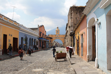
For those unfamiliar with Antigua, it is a beautiful city, the former capital of Spanish Central America and the home of more than a dozen Spanish language schools. Most of the schools 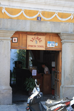 provide a 1:1 program for your selected number of hours per day. I figured if I wanted to learn some more of the language, Antigua was the place to accomplish the task. Gary and scoped out the various schools, chose the Ixchel Spanish School, and signed up for the 6 hour per day program. I found that four hours in the morning and two more in the afternoon to be challenging and I have no doubt that Gary found it even more so, given he had no prior Spanish schooling but for a dose of the Rosetta Stone. If a search for the Ixchel School or Antigua's Spanish schools in general has brought you to this site, I highly recommend Ixchel as they paid attention to what I told them I wanted to get from the course and lined up two teachers (morning and afternoon) who took me from one tense to four and really boosted my vocabulary. I was looking to give my Spanish a boost and Mariella and Angelica at Ixchel pulled it off. Bear in mind, I'm 48 years old and the old brain is getting a little more dense as to new tricks, but I really figured if I could get through law school at 42, I would have a shot at improving my Spanish at this stage in life as well. provide a 1:1 program for your selected number of hours per day. I figured if I wanted to learn some more of the language, Antigua was the place to accomplish the task. Gary and scoped out the various schools, chose the Ixchel Spanish School, and signed up for the 6 hour per day program. I found that four hours in the morning and two more in the afternoon to be challenging and I have no doubt that Gary found it even more so, given he had no prior Spanish schooling but for a dose of the Rosetta Stone. If a search for the Ixchel School or Antigua's Spanish schools in general has brought you to this site, I highly recommend Ixchel as they paid attention to what I told them I wanted to get from the course and lined up two teachers (morning and afternoon) who took me from one tense to four and really boosted my vocabulary. I was looking to give my Spanish a boost and Mariella and Angelica at Ixchel pulled it off. Bear in mind, I'm 48 years old and the old brain is getting a little more dense as to new tricks, but I really figured if I could get through law school at 42, I would have a shot at improving my Spanish at this stage in life as well.
Besides going there for school, Antigua is a safe and beautiful place to spend a few very mellow weeks. Ixchel arranged for a home stay with a family who generally host two to four students at the school. 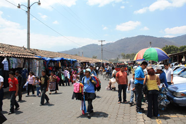 The folks we stayed with were wonderful hosts, the food was good and there was plenty of it. I'm not a big eater but big eater G was taken care of. Antigua has a substantial expatriot community and there is no lack of things to do if you have to stay in touch with your Ingles side or explore the more local fare. Movies, markets, and restaurants provide lots to do and the agentes viajes on the square and elsewhere can cover everything from a trip to Pacaya volcano to overnights to Tikal and the Pacific Coast beaches. Like any operator, you want to sniff around a bit before plunging in but we found Maya Tours on the main square to be well spoken of and they did a good job for us as to our volcano hike. There is also an expatriot outfit ("OX") that specializes in volcano climbs and overnights. Had I more time, I would have taken a trip up one of the other volcanos with that outfit. The folks we stayed with were wonderful hosts, the food was good and there was plenty of it. I'm not a big eater but big eater G was taken care of. Antigua has a substantial expatriot community and there is no lack of things to do if you have to stay in touch with your Ingles side or explore the more local fare. Movies, markets, and restaurants provide lots to do and the agentes viajes on the square and elsewhere can cover everything from a trip to Pacaya volcano to overnights to Tikal and the Pacific Coast beaches. Like any operator, you want to sniff around a bit before plunging in but we found Maya Tours on the main square to be well spoken of and they did a good job for us as to our volcano hike. There is also an expatriot outfit ("OX") that specializes in volcano climbs and overnights. Had I more time, I would have taken a trip up one of the other volcanos with that outfit.
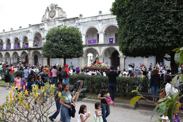
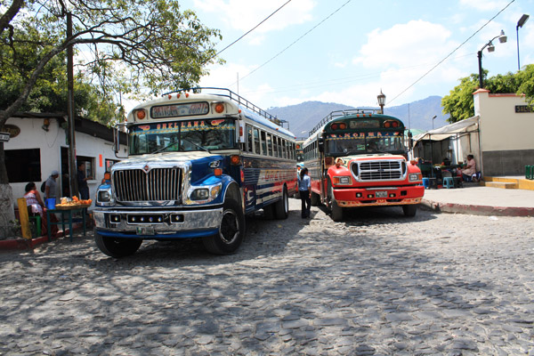
Antigua is a walking town with good connections to Guatemala City ("Guate") and the neighboring communities. During our stay, we also visited a number of the neighboring pueblos to 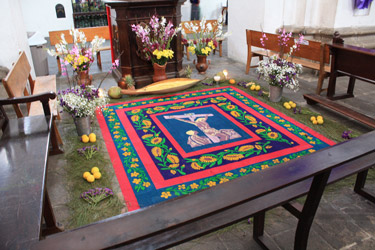 shop or view the festivities surrounding the lead up to Semana Santa, including the incredible "carpets" created from dyed sawdust that adorn the various churches. Antigua is a town of active churches and ruined churches and convents. I would hazard a guess that every Franciscan, Dominican, Jesuit or similar group has made its presence known in Antigua. The tectonic nature of the neighborhood has certainly played a part in providing ample ruins as Antigua has been rocked by world class earthquakes and continues to rock and roll to this day, depending upon the mood swings of Volcan Fuego. A visit to Antigua should include the walking tour of the churches and ruins as they are everwhere and such a tour will undoubtably include other local folklore as well. shop or view the festivities surrounding the lead up to Semana Santa, including the incredible "carpets" created from dyed sawdust that adorn the various churches. Antigua is a town of active churches and ruined churches and convents. I would hazard a guess that every Franciscan, Dominican, Jesuit or similar group has made its presence known in Antigua. The tectonic nature of the neighborhood has certainly played a part in providing ample ruins as Antigua has been rocked by world class earthquakes and continues to rock and roll to this day, depending upon the mood swings of Volcan Fuego. A visit to Antigua should include the walking tour of the churches and ruins as they are everwhere and such a tour will undoubtably include other local folklore as well.
|
