-
Mt. Bierstadt Group Summit - Front Range, Colorado
-
A rest before the summit push on Dallas Peak - San Juan Range, Colorado
-
Broken Ankle + 6 Miles = Tired
-
The classic San Juan approach - San Juan Range, Colorado
-
Overlooking Noname Basin from Twin Thumbs Pass - San Juan Range, Colorado
-
Upper Noname Basin - San Juan Range, Colorado
-
Nearing Noname Cabin - San Juan Range, Colorado
-
Twin Thumbs Twins - San Juan Range, Colorado
-
Nearing the summit of Pt. 13,736 - Sawatch Range, Colorado
-
Blustery day on Iowa Peak - Sawatch Range, Colorado
-
Morning snow at 15k, Cerro Ramada - Cordillera Ramada
-
Artesonraju from the summit of Nevado Pisco - Cordillera Blanca, Peru
-
February crowds on Gray's Peak - Front Range, Colorado
-
Kicking steps on Cerro Lliani - Cordillera Vilcanota, Peru
-
Final traverse to the summit of Wheeler Mountain - Ten Mile Range, Colorado
-
The long walk to Pachanta - Cordillera Vilcanota, Peru
- banner31
Afternoon at 17k on Cerro Ramada - Cordillera Ramada, Argentina
- banner22
The final ridge on Iowa Peak - Sawatch Range, Colorado
-
Summer summit on Longs Peak - Front Range, Colorado
-
A rest day at the Pachanta Hot Springs - Cordillera Vilcanota, Peru
-
Mind over matter on Mt. Parnassas - Front Range, Colorado
-
Rest stop on Cerro Lliani - Cordillera Vilcanota, Peru
- banner30
Post nap surprise on Cerro Ramada - Cordiller Ramada, Argentina
-
Summit on Cerro Lliani - Cordillera Vilcanota, Peru
- banner23
Ridge walking on Grizzly Peak - Sawatch Range, Colorado
-
Enroute the summit via the West Ridge on Pacific Peak - Ten Mile Range, Colorado
-
Mule train bound for Chilca - Cordillera Vilcanota, Peru
-
Taking in the view from Fletcher Peak - Ten Mile Range, Colorado
-
Hiking on Silverheels - Mosquito Range, Colorado
-
Traversing! Gladstone Peak - San Juan Range, Colorado
- banner24
The best of times at Willow Lake - Sangre de Christo Range, Colorado
- banner29
High Altitude Cerebral Edema? - Cordillera Ramada, Argentina
-
Bound for Chilca - Vilcanota Range, Peru
-
Going alpine light, Holy Cross Ridge - Sawatch Range, Colorado
-
Cumbre! Campa I - Cordillera Vilcanota, Peru
-
Roadside lunch with the best of company - Cordillera Vilcanota, Peru
- banner25
Long ridge walk to the summit of California Peak - Sangre de Christo Range, Colorado
- banner28
Crossing el Rio Colorado . . . in the afternoon - Cordillera Ramada, Argentina
- banner37
Dealing with Fall snows high on Casco Peak - Sawatch Range, Colorado
-
Moonrise over Mercedario - Cordillera Ramada, Argentina
-
Still climbing at 20,900 on Cerro Ramada - Cordiller Ramada, Argentina
-
Talus on Halo Ridge, Mt. of the Holy Cross - Sawatch Range, Colorado
- banner26
Deteriorating conditions on Mt. Arkansas - Ten Mile Range, Colorado
- banner27
After the climb - Cordillera Ramada, Argentina
- banner38
Taking in the view from the summit of Crystal Peak - Tenmile Range, Colorado
-
Topping out on Mt. Arkansas' North Couloir - Mosquito Range, Colorado
-
Glissade on Mt. Arkansas - Mosquito Range, Colorado
-
Hard snow morning on Teakettle Mountain - San Juan Range, Colorado
-
Spring snow announces the start of the climb on Dallas Peak - San Juan Range, Colorado
-
Crossing the Eolus Catwalk - San Juan Range, Colorado

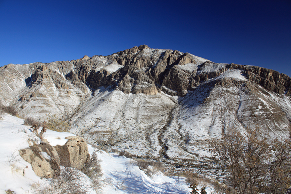
 I left at 7 a.m., starting from the same trailhead as Guadalupe but immediately cutting over to the Tejas Trail and stuck with that course for about a half mile outbound from the canyon to the Frijole Trail. The route to the top would be via Bear Canyon but long before reaching the base of the canyon, I'd have to get around the base of the mountain. The snow on the trail was beaten a bit but just as icy as the start the day before. The ice crunched underfoot but soon enough I was at the start of the Frijole Trail that would wind for a mile around the base, gently climbing along the way and dropping in and out of small drainages.
 After a bit over a mile, the trail up Bear Canyon lay at my feet and I had only to push up about 1500 feet over about 1.8 miles, mostly in the sun but perhaps one third in shadow. I knew from the day before that shadows would mean snow but I soon found out that sunny areas also promised snow in this ascending canyon. The first section switched back on the southern flank before traversing up to cross over the drainage at about the one third mark. The trail was now in shadow and working its way up the right sidewall through boulders and scrub oak. The snow got deeper, many sections of 18 to 24 inch snow with one lovely section where it had drifted to about 4 feet in depth, perhaps not 4 feet exactly but I know it came up to my armpits after the crust gave way.
 I fought my way up through the center third until the canyon widened out and I could see that the upper lip that I hoped was the rim was in fact the rim proper. But to get to that rim, I had a good dozen switchbacks to contend with and lots of trail onto which the wind had deposited that perfectly triangular drift of snow, you know where you can skirt the trail's outer edge or, if just inbound a bit, you get to posthole to your heart's content. I got some crust, some postholes and some trail edge, now pushing beyond the end of a track previously kicked as far as the center section of the canyon.
 After one of those eternity periods (probably all of an hour), I postholed through deepening snow to the rim's edge. I figured I would at least get the satisfaction of a trail juncture sign, marking the route to Hunter Peak versus the route into the "Bowl", the tree covered plateau that lies behind the precipices of Hunter. What I got was no sign and no sign of a trail to the summit of Hunter . . . why should there be, the area was covered with 18 to 24 inches of snow. I reverted to old fashioned map reading and took the shallow gully that would lead to a point just to the right side of the summit and intersect the cliff edge for sure. I found some wind hammered sections but they were few and far between as I mostly postholed my way upward until I spotted a trail swale in the glancing light.
 The swale was obviously the trail but it soon petered out and I orienteered for another hundred yards before again catching sign of the trail and then, once the trees got thick, picked out trimmed limbs and the shadow of the trail runnel. After perhaps a half hour of slow slog, I spotted a trail junction sign and found that it indicated the start of the short stub trail the summit of Hunter Peak. Ten minutes later, I trudged the reverse slope behind the cliffy face and stood on the summit proper. I'd ended up kicking a route from the middle of Bear Canyon upward but it worth the effort to be the first person post storm to summit this less popular peak.
 A brief lunch on the wind free summit and then I was headed down, retracing my trail through he woods to the top of the canyon. I descended and at perhaps the half way point, I encountered the tracks of another climber who had turned. Not surprising . . . as almost all of the other climbers I came across were ill prepared for the snow . . . simply a sign of the conditions anticipated as these conditions appears to be the rare exception for the more southerly based climbing crowd. I exited the canyon and found a more traffic on the Frijole trail as the afternoon hikers came out to enjoy the warming temps and noticeably less amount of snow on the trail.