Lackawanna Peak
May 22, 2010 - Spring - South Slopes
The plan was to find a climb that would not have an overly long approach through spring snow filled forest that would translate to a post hole hell at the end of the climb. Lackawanna Peak offered just the solution to the problem, a climb that would "attack the fall line" and do so right from the door of the truck.
 We took off from Cheyenne on Friday night and camped outside the gate of the campground near the head of Twin Lakes. The campground was closed but the entry drive offered a very flat gravel pad which was all we needed for a 6 hour night. We had the tent up by 10:30 and set the alarm for 5 a.m. There was little chance of a thunderstorm the following day and we knew that the climb would be short, hence a start of around 6 a.m. seemed plenty reasonable with regard to the alpine start. The alarm was almost welcome when it went off as the dead still of the prior night had turned into a windy early morning as the tent flapped in the breeze and the occasional gust drove part of the tent down enough to tap G in the head. We were up right away, the camp was packed, and we were soon on the road, by 5:25 or so. We took off from Cheyenne on Friday night and camped outside the gate of the campground near the head of Twin Lakes. The campground was closed but the entry drive offered a very flat gravel pad which was all we needed for a 6 hour night. We had the tent up by 10:30 and set the alarm for 5 a.m. There was little chance of a thunderstorm the following day and we knew that the climb would be short, hence a start of around 6 a.m. seemed plenty reasonable with regard to the alpine start. The alarm was almost welcome when it went off as the dead still of the prior night had turned into a windy early morning as the tent flapped in the breeze and the occasional gust drove part of the tent down enough to tap G in the head. We were up right away, the camp was packed, and we were soon on the road, by 5:25 or so.
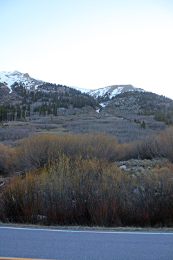
The drive to the start of the climb was short and we were soon at the road closure for Independence Pass. I knew that the road was not officially open for another week but I hoped that perhaps the highway crew might have left the gate open and perhaps allow us to make it to the hairpin turn. No such luck . . . so we 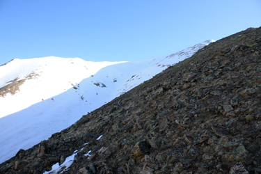 knew that we were in for the steepest climbing option on Lackawanna. We pulled to the side of the road and parked across from the base of the avalanche chute that points to a false summit, beyond which lies the hidden 13,800+ summit of the peak. Gear was for a few minutes and we left behind the majority of the cold weather garb and debated whether those extra pounds called crampons were really needed. knew that we were in for the steepest climbing option on Lackawanna. We pulled to the side of the road and parked across from the base of the avalanche chute that points to a false summit, beyond which lies the hidden 13,800+ summit of the peak. Gear was for a few minutes and we left behind the majority of the cold weather garb and debated whether those extra pounds called crampons were really needed.
I had no doubt that crampons would be a necessity if we were to take a snow route up but I also figured that if there was no overnight ice in sight, the warmer temps to come would allow a plunge stepping descent down a snow field from on high. We attached our axes to the packs and were off across the road and summit bound. The first 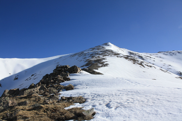 segment of the climb is up through patches of willows that cover the alluvial fan that has formed at the base of the draw/avalanche chute. We found a series of climber and game trails that led through gaps in the willows, allowing us to avoid any willow bashing to get to the start of the south slope. Once at the base of the ridge, we left the willows behind and worked our way up along the ridge that forms the eastern flank of the avi chute, aiming for a turret of rock that seemed to indicate the southern terminus of the ridge we were planning to climb. segment of the climb is up through patches of willows that cover the alluvial fan that has formed at the base of the draw/avalanche chute. We found a series of climber and game trails that led through gaps in the willows, allowing us to avoid any willow bashing to get to the start of the south slope. Once at the base of the ridge, we left the willows behind and worked our way up along the ridge that forms the eastern flank of the avi chute, aiming for a turret of rock that seemed to indicate the southern terminus of the ridge we were planning to climb.
 We found the trees to be full of deep and steeply sloping snow hummocks so instead of attacking them straight on, we trended to the ridge crest proper and with one short steep section, we were able to bypass most of the snow and only had to kick steps up one short steep section to gain the rocky slope above tree line. Once on the rock, we took a traversing path along the side of the ridge, steadily climbing but avoiding the ridge crest proper as we were on the lee side of the ridge. Once above tree line, the route was obvious, climb to the summit, though we knew that the "summit" we were aiming for was really a false summit guarding another slope that would lead us to the true highpoint. We found the trees to be full of deep and steeply sloping snow hummocks so instead of attacking them straight on, we trended to the ridge crest proper and with one short steep section, we were able to bypass most of the snow and only had to kick steps up one short steep section to gain the rocky slope above tree line. Once on the rock, we took a traversing path along the side of the ridge, steadily climbing but avoiding the ridge crest proper as we were on the lee side of the ridge. Once above tree line, the route was obvious, climb to the summit, though we knew that the "summit" we were aiming for was really a false summit guarding another slope that would lead us to the true highpoint.
We made the saddle like hump that is about midway up the ridge and took our first break. It was early in the season and though we had been to Argentina earlier in the year, I was carrying about 5 pounds more than I wished to and G had been focusing his training toward martial arts, setting the stage for both of us being a bit slow and out of "mountain shape." We stopped for about 5 minutes, drank some Cytomax, shot a Gu and then 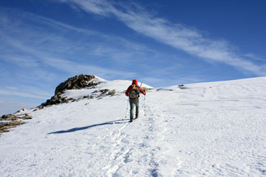 we were again on our way. We climbed steadily up the ridge, staying in the wind shadow before making the false summit and beginning the final trek to the top. The geometry is such that one does not really get a view of the final summit until another false summit or better stated, a pre-summit flat spot is achieved from which the summit proper is suddenly obvious. we were again on our way. We climbed steadily up the ridge, staying in the wind shadow before making the false summit and beginning the final trek to the top. The geometry is such that one does not really get a view of the final summit until another false summit or better stated, a pre-summit flat spot is achieved from which the summit proper is suddenly obvious.
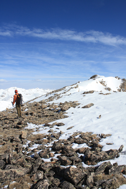
We climbed on and on as this portion of the climb had downgraded to a slog as the remaining elevation to the summit flat was only slowly ticking away. The slope just went on and on until finally, it flattened out and we spotted the summit hump just a hundred yards away. We walked to the summit proper and after all of 30 seconds, we backtracked a short distance and dropped 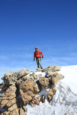 down the flank of the west side of the ridge to find a spot out of the wind. Now it was time for a break for some food and drink before we headed back down. We probably sat for no more than 15 minutes, including the time it took me to scamper back to the crest of the ridge to take a photo or two and sample the 60 mph wind gust that took my ball cap into the next valley and signaled that the weather forecast was not wholly inaccurate. Our hands were now getting cold so it was clearly time to move on. down the flank of the west side of the ridge to find a spot out of the wind. Now it was time for a break for some food and drink before we headed back down. We probably sat for no more than 15 minutes, including the time it took me to scamper back to the crest of the ridge to take a photo or two and sample the 60 mph wind gust that took my ball cap into the next valley and signaled that the weather forecast was not wholly inaccurate. Our hands were now getting cold so it was clearly time to move on.
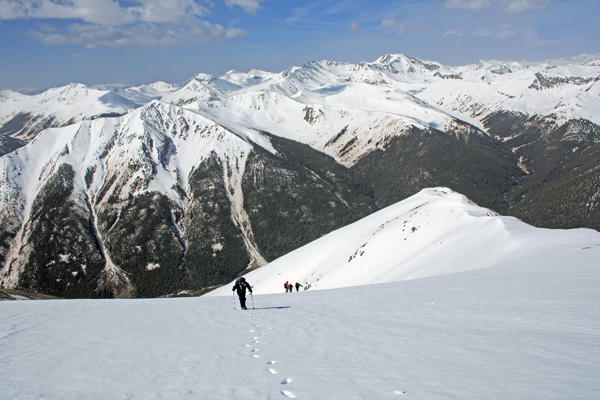
Our ascent up the ridge was off snow but the avi track/gully that one sees from the road extends almost to the summit and that was to be our route down. As we descended the ridge to the top of the snow, the first of a party of four was nearing the ridge so we took the opportunity to inquire of the snow, kind of an important matter as we opted to not bring the crampons along. Their lead noted that the snow was hard in a spot or two but that the sun was doing the trick . . . that sounded like a plunge step descent to us. We passed the remainder of the party as we dropped onto the steeper portion of the snowfield and exchanged a bit of info as to what else . . . the distance 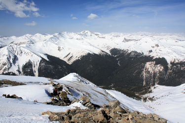 to the summit. Our drop down the wide gully was the easiest and best way down as the snow took a solid heel but little more until we hit about 500 feet of vertical where the warm valley air made for postholing conditions. to the summit. Our drop down the wide gully was the easiest and best way down as the snow took a solid heel but little more until we hit about 500 feet of vertical where the warm valley air made for postholing conditions.
We post holed for 400 or 500 vertical feet, not bad . . . mid shin . . . and then we were on compact snow remaining from a slide sometime during the winter. The broken branches, tree trunks and other debris poked up through the still very compact snow that was our course to nearly the edge of the road. Our Lackawanna climb was short and sweet, taking only 4:30 hours from start to finish and only 2:45 to summit.
|
