Mt. Blaurock
January 20, 2012 - South Ridge from Winfield Townsite
The weekend forecast was screaming that something had to be on our climbing schedule, but what would it be? Well, how often can one access the Winfield Townsite in mid winter . . . not often. This year however, the snow has been light in that part of the Sawatch so the opportunity to score another Bicentennial seemed to be available, not a given in winter, but a possibility.
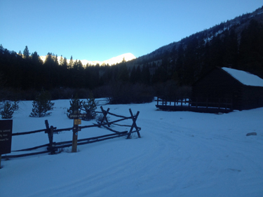 The departure from Cheyenne was too early, 3 a.m. but having lived on the east coast, I know the loss of a climbing weekend missed in Colorado . . . if a dark 30 departure is in the cards then that is the hand I play. We pulled into Winfield, the road was open as alleged, and did the final gear sort. Our next move was as always . . . a final five minutes or so in the heat of the vehicle . . . at least until the big hand hits a round number, which requires us to depart for the mountain. Our route took us out of Winfield on the road leading up valley and past the cemetery that holds some of this mining communities earlier residents. The road continued, well beaten down by snow machines and a four wheeler or two. The departure from Cheyenne was too early, 3 a.m. but having lived on the east coast, I know the loss of a climbing weekend missed in Colorado . . . if a dark 30 departure is in the cards then that is the hand I play. We pulled into Winfield, the road was open as alleged, and did the final gear sort. Our next move was as always . . . a final five minutes or so in the heat of the vehicle . . . at least until the big hand hits a round number, which requires us to depart for the mountain. Our route took us out of Winfield on the road leading up valley and past the cemetery that holds some of this mining communities earlier residents. The road continued, well beaten down by snow machines and a four wheeler or two.
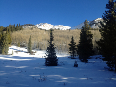 I'd spotted a point on the map, just past Gray Copper creek, that in my humble map reading opinion, would yield a relatively open route upward to the ridge leading to the summit. The ridge offered the chance to get windblown but so far the wind was not an issue and the slopes were bathed in warm sunlight. We crossed the frozen creek and headed up, first crossing a small meadow before going into the sparse aspen and then bushwhacking onward through pines. I assume there is a summer trail, but until we broke the snow line onto the bare portions of the ridge, there was no sign of a clearly defined route. However, that is the reason we climb the "lesser" peaks for their lack of herd paths and cotton. I'd spotted a point on the map, just past Gray Copper creek, that in my humble map reading opinion, would yield a relatively open route upward to the ridge leading to the summit. The ridge offered the chance to get windblown but so far the wind was not an issue and the slopes were bathed in warm sunlight. We crossed the frozen creek and headed up, first crossing a small meadow before going into the sparse aspen and then bushwhacking onward through pines. I assume there is a summer trail, but until we broke the snow line onto the bare portions of the ridge, there was no sign of a clearly defined route. However, that is the reason we climb the "lesser" peaks for their lack of herd paths and cotton.
 One of the attractions for this climb was that it was going to be a shorter distance from car to summit. But the math associated with that distance advantage must necessarily tell the other side of the equation, 4000 feet of vertical must still be achieved, regardless. We'd started off in snowshoes but after gaining no more than 200 vertical feet from the road, we strapped the shoes to the pack and found it easier going for a while . . . After gaining our first 600 feet we came into thinner trees and rather than moving up the nose of the slope proper, we cut to the right and figured to come onto the ridge from the side. The snow got deeper and we thought about going back to the shoes, but the need to bust a 2" slab with every step just did not seem to offer any really good options. One of the attractions for this climb was that it was going to be a shorter distance from car to summit. But the math associated with that distance advantage must necessarily tell the other side of the equation, 4000 feet of vertical must still be achieved, regardless. We'd started off in snowshoes but after gaining no more than 200 vertical feet from the road, we strapped the shoes to the pack and found it easier going for a while . . . After gaining our first 600 feet we came into thinner trees and rather than moving up the nose of the slope proper, we cut to the right and figured to come onto the ridge from the side. The snow got deeper and we thought about going back to the shoes, but the need to bust a 2" slab with every step just did not seem to offer any really good options.
 We came around the side of the ridge and saw that we had screwed up a bit. The ridge, from anywhere on the right side, offered slopes with avi potential. We stopped and gauged the terrain and the snow. The vistas far and wide offered no sign of other slides, but that does not mean that we cannot initiate the virgin event for any given slope. Our solution was to pick the shortest and most shallow line possible, meaning that our total gain was no more than about 40 vertical feet but we paid a steep price for our route selection. Our exercise of care, caution, spacing, or the lack thereof, meant slow going, we spent an hour, no lie, covering 150 feet through surface crust and facets. We ended up atop the slope, beat nearly to exhaustion having done battle with the crappy snow. We came around the side of the ridge and saw that we had screwed up a bit. The ridge, from anywhere on the right side, offered slopes with avi potential. We stopped and gauged the terrain and the snow. The vistas far and wide offered no sign of other slides, but that does not mean that we cannot initiate the virgin event for any given slope. Our solution was to pick the shortest and most shallow line possible, meaning that our total gain was no more than about 40 vertical feet but we paid a steep price for our route selection. Our exercise of care, caution, spacing, or the lack thereof, meant slow going, we spent an hour, no lie, covering 150 feet through surface crust and facets. We ended up atop the slope, beat nearly to exhaustion having done battle with the crappy snow.
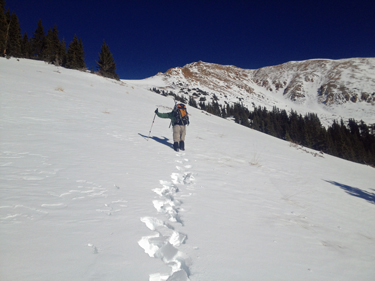
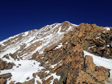 Our reward was a gentle rolling slope that extended for about 200 yards before the slope took a more upward tack and then, after the first bump, added the challenge of loose snow covered talus, not frozen but rocking and ready fto challenge our our travel upward. In the mean time, I am trying my hardest to get some of the climbing mojo back, and even after downing 3 Gu's and a half quart over 15 minutes, I was still fighting the fatigue from the slope below. We pushed on upward, I was in the lead but my arms were limp from the fight and Bob was no faring much better. We gained elevation albeit slowly until we broke through the most difficult portion of the ridge (all of Class 2 and no more) and hit a gravelly course up a gully leading to the upper frank of the saddle connecting Blaurock to Ervin in the distance. Our reward was a gentle rolling slope that extended for about 200 yards before the slope took a more upward tack and then, after the first bump, added the challenge of loose snow covered talus, not frozen but rocking and ready fto challenge our our travel upward. In the mean time, I am trying my hardest to get some of the climbing mojo back, and even after downing 3 Gu's and a half quart over 15 minutes, I was still fighting the fatigue from the slope below. We pushed on upward, I was in the lead but my arms were limp from the fight and Bob was no faring much better. We gained elevation albeit slowly until we broke through the most difficult portion of the ridge (all of Class 2 and no more) and hit a gravelly course up a gully leading to the upper frank of the saddle connecting Blaurock to Ervin in the distance.
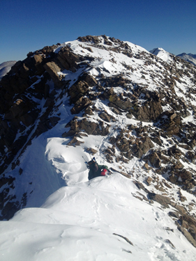
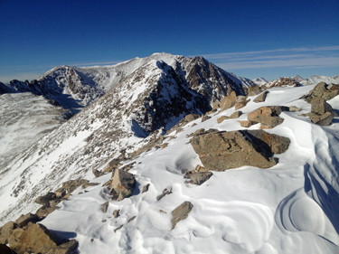
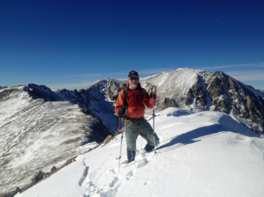
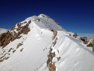 We took a breather and then both of us started up for the summit ridge, knowing that we had no less than a quarter mile traverse along the ridge to get the highest point. The snow that dogged us below continued to play the same game up high. Where one usually finds a ridgeline snowfield behind the cornice wind hammered and hard, we found more of the two foot quicksand that we wanted no part of. Our only viable route option was to hug the rock/snow interface until we finally got to the ridge line proper where the snow hardened to the consistency we wanted, i.e. something that would take a good well kicked step. Finally, the fun part arrived as we crossed a knife edge and then came to the high point, or was it? We took a breather and then both of us started up for the summit ridge, knowing that we had no less than a quarter mile traverse along the ridge to get the highest point. The snow that dogged us below continued to play the same game up high. Where one usually finds a ridgeline snowfield behind the cornice wind hammered and hard, we found more of the two foot quicksand that we wanted no part of. Our only viable route option was to hug the rock/snow interface until we finally got to the ridge line proper where the snow hardened to the consistency we wanted, i.e. something that would take a good well kicked step. Finally, the fun part arrived as we crossed a knife edge and then came to the high point, or was it?
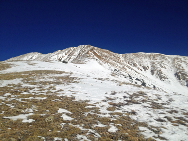
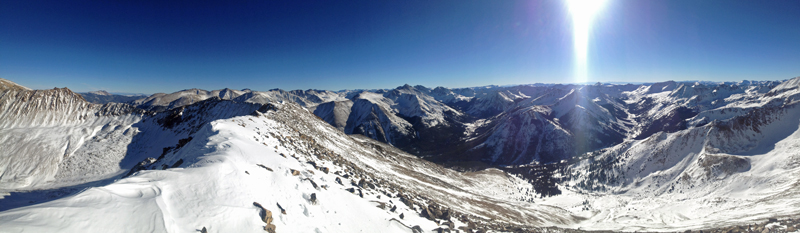
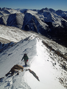 I knew that the center high point was not quite the summit because the juncture of the ridge connecting this peak to Rinker in the far distance would mark the proper point, an arete. That meant not just traversing a bit further but dropping down 75 feet or so and working our way through more garbage snow and loose talus, all focused on cranking one of us the right way, in a musculo-skeletal way that I did not want any part of. Regardless, we had to move along and after dropping and re-climbing, we scored the summit of Mt Blaurock, just 3 miles from the truck in the lighting time of 6 1/2+ hours. The snow sucked. I knew that the center high point was not quite the summit because the juncture of the ridge connecting this peak to Rinker in the far distance would mark the proper point, an arete. That meant not just traversing a bit further but dropping down 75 feet or so and working our way through more garbage snow and loose talus, all focused on cranking one of us the right way, in a musculo-skeletal way that I did not want any part of. Regardless, we had to move along and after dropping and re-climbing, we scored the summit of Mt Blaurock, just 3 miles from the truck in the lighting time of 6 1/2+ hours. The snow sucked.
 We spent a half hour on the top knowing that the sun that made us so warm would soon be replaced by the wind that Pachamama sends along to remind all climbers not to tarry too long atop the highest point. We left at 3 p.m., knowing that we would arrive at the truck under headlamp but also knowing there would be no serious route finding issues. Rather than do an up and down back traverse of the ridge line, we did the side slope traverse that I always hate, the one usually cliffs out and the one that is always so alluring and always makes one wonder why am I doing this again? We got our just reward, the need to climb up 50 feet to avoid a cliff sided gully but then, with no further major effort, we regained the saddle point that marked the end of our earlier ridge climb. We spent a half hour on the top knowing that the sun that made us so warm would soon be replaced by the wind that Pachamama sends along to remind all climbers not to tarry too long atop the highest point. We left at 3 p.m., knowing that we would arrive at the truck under headlamp but also knowing there would be no serious route finding issues. Rather than do an up and down back traverse of the ridge line, we did the side slope traverse that I always hate, the one usually cliffs out and the one that is always so alluring and always makes one wonder why am I doing this again? We got our just reward, the need to climb up 50 feet to avoid a cliff sided gully but then, with no further major effort, we regained the saddle point that marked the end of our earlier ridge climb.
 Now for the trip back through the rock and roll world of unfrozen talus, for about 1500 vertical feet. Expensive, the drop set me back $120 as I first bent one BD elliptical shaft hiking pole into a gonna break sooner than later curve . . . followed by a no nonsense slip and snap job on the other pole. Bob mentioned that he needed a set of baskets for his poles and by the end of the climb, he got what he wanted, from my now ruined poles. We finally made the smoother rolling part of the ridge and I noted that we would drop right off the nose of the ridge, no fooling around with any side slopes. We did just that but not before I stopped to repair my snowshoe, the one that broke on the way up when a rivet pulled through, leaving the foot bound on one side only. Now for the trip back through the rock and roll world of unfrozen talus, for about 1500 vertical feet. Expensive, the drop set me back $120 as I first bent one BD elliptical shaft hiking pole into a gonna break sooner than later curve . . . followed by a no nonsense slip and snap job on the other pole. Bob mentioned that he needed a set of baskets for his poles and by the end of the climb, he got what he wanted, from my now ruined poles. We finally made the smoother rolling part of the ridge and I noted that we would drop right off the nose of the ridge, no fooling around with any side slopes. We did just that but not before I stopped to repair my snowshoe, the one that broke on the way up when a rivet pulled through, leaving the foot bound on one side only.
 I'm a ten essentials kind of guy, so the cord fix was made before we hit the snow and then down we went. I did not know if I would need the shoe but I sure wasn't going to jury rig the thing standing in two feet of facets with cold hands in the dark. We never did use the shoes as we made our beeline course to the road below and not soon enough dropping out of the trees onto the well compacted road at the onset of headlamp time. The rest of the hike out was made by the light of the lamp and we arrived at the truck at a bit after six, in the dark, and wondering who came up with the idea that this climb would be short and sweet. I'm a ten essentials kind of guy, so the cord fix was made before we hit the snow and then down we went. I did not know if I would need the shoe but I sure wasn't going to jury rig the thing standing in two feet of facets with cold hands in the dark. We never did use the shoes as we made our beeline course to the road below and not soon enough dropping out of the trees onto the well compacted road at the onset of headlamp time. The rest of the hike out was made by the light of the lamp and we arrived at the truck at a bit after six, in the dark, and wondering who came up with the idea that this climb would be short and sweet.
|
