The Jagged, Pigeon & Turret Mts. Attempt
August 8-9, 2012 - Upper Noname Basin to Needleton via Noname Creek
Day 1 . . .
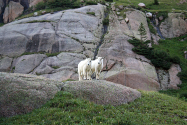
We woke the next morning with a herd of goats having invaded during the night, making themselves busy looking for some pee to paw or some other mischief. We paid little attention to them as we broke camp and re-divided the contents of our packs. I took the sleeping bag pads and a lot of other light goods and the weight went to G and Bob. I may not have liked the idea but realized that I could not get down to the meadow below, nor the river much further on, with a full load.
 We had some breakfast and then I headed out with the agreement that I would only go half way down to the Noname meadow, crossing the upper open and lightly willowed portion of the descent but not dropping into the trees where I would be invisible to G and Bob coming from behind. I knew that I would be slow but getting a head start would be my chance to gauge the condition of the ankle and develop a sense of confidence, or losing the same, of my ability to travel. The night had been long and even with another quick icing, that foot was really hurting, ace bandage or not. The serious swelling had started and I was faced with two obvious lumps and pretty much no stability as to movement in the same direction as the roll. We had some breakfast and then I headed out with the agreement that I would only go half way down to the Noname meadow, crossing the upper open and lightly willowed portion of the descent but not dropping into the trees where I would be invisible to G and Bob coming from behind. I knew that I would be slow but getting a head start would be my chance to gauge the condition of the ankle and develop a sense of confidence, or losing the same, of my ability to travel. The night had been long and even with another quick icing, that foot was really hurting, ace bandage or not. The serious swelling had started and I was faced with two obvious lumps and pretty much no stability as to movement in the same direction as the roll.
 I left, crossed the stream, and at first stayed high before finding a game trail and following it on down through a series of grass and willow covered slopes, moving with deliberation and watching foot fall of the right leg. I really did not want to re-roll or worse yet, crank the ankle so it would not allow me to continue. I made the lowest, pre-tree grassy area and within a minute or two the others caught up. G took the lead, ranging out ahead and picking the route on through the trees and cliff bands, skirting granite outcrops in a slow descending traverse intended to rejoin the creek after it appeared to fall over a cliff band. I was really glad to have him scouting ahead as I really did not want to get cliffed out and have to climb back up. I left, crossed the stream, and at first stayed high before finding a game trail and following it on down through a series of grass and willow covered slopes, moving with deliberation and watching foot fall of the right leg. I really did not want to re-roll or worse yet, crank the ankle so it would not allow me to continue. I made the lowest, pre-tree grassy area and within a minute or two the others caught up. G took the lead, ranging out ahead and picking the route on through the trees and cliff bands, skirting granite outcrops in a slow descending traverse intended to rejoin the creek after it appeared to fall over a cliff band. I was really glad to have him scouting ahead as I really did not want to get cliffed out and have to climb back up.
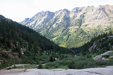
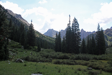
 G picked the route well and we broke into a side drainage that was willow choked but offered a route down to the main creek just a hundred yards or below its course through a vertical slot. The next adventure as to follow the stream down across boulders and talus to the flats below, where I knew that the trail from the Animas River to Jagged would be found. I again picked my way down, depending wholly upon the hiking poles for support and watching for rockers and other pitfalls that I knew were waiting to nail me. We made the head of the meadow and I stopped to ice the foot again in the creek. G picked the route well and we broke into a side drainage that was willow choked but offered a route down to the main creek just a hundred yards or below its course through a vertical slot. The next adventure as to follow the stream down across boulders and talus to the flats below, where I knew that the trail from the Animas River to Jagged would be found. I again picked my way down, depending wholly upon the hiking poles for support and watching for rockers and other pitfalls that I knew were waiting to nail me. We made the head of the meadow and I stopped to ice the foot again in the creek.
 Our game plan called for breaking the trip into pieces and the first, and I felt most major, was getting from the upper valley to Noname meadow. We'd pulled that off and it was only 10:30 in the morning. Our next plan called for getting to the Jagged Cabin and deciding again to stop or proceed on down. We knew that the cabin represented a committal point as we would lose the open ground necessary for a PLB pick-up without a major ground effort. We made the cabin without too much trouble and discussed the next step. Our game plan called for breaking the trip into pieces and the first, and I felt most major, was getting from the upper valley to Noname meadow. We'd pulled that off and it was only 10:30 in the morning. Our next plan called for getting to the Jagged Cabin and deciding again to stop or proceed on down. We knew that the cabin represented a committal point as we would lose the open ground necessary for a PLB pick-up without a major ground effort. We made the cabin without too much trouble and discussed the next step.
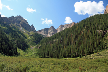
 I felt good and really wanted to get as much distance under me as I could. We committed to going for the river. The trail led on through some dead fall and then we missed an up and over move that caused us to drop into the creek proper to get around a creek side cliff. We found the group error trail, climbed back up and made the descent through the thick woods. We covered the distance to the first campsite found if one is coming up and called that the lunch spot. The packs got a bit lighter and after 1/2 hour, we were on the move again. The valley opened up a bit and, here and there, we would lose the trail, picking it up again without too much trouble a dozen or fifty yards later. I felt good and really wanted to get as much distance under me as I could. We committed to going for the river. The trail led on through some dead fall and then we missed an up and over move that caused us to drop into the creek proper to get around a creek side cliff. We found the group error trail, climbed back up and made the descent through the thick woods. We covered the distance to the first campsite found if one is coming up and called that the lunch spot. The packs got a bit lighter and after 1/2 hour, we were on the move again. The valley opened up a bit and, here and there, we would lose the trail, picking it up again without too much trouble a dozen or fifty yards later.
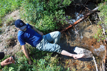
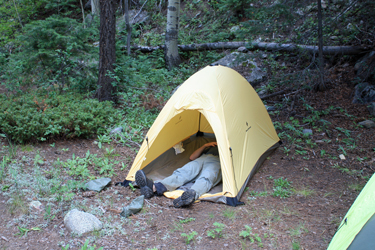 The trail then took to climbing the north flank of the canyon, which we assumed was required due to a jumble of falls below in the canyon bottom. Such is the case and for a mile or two as the trail first climbs and then drops like heck to the vicinity of the river. At this point there are no route finding issues as the trail is well cairned. About 45 minutes later, I hobbled into the camp adjacent to the river. It was now 3:30 and this would be it for the day. I set up my tent and lay down for a moment, that was all it took. Later, we all headed for the river, though my main goal was to ice the foot as the others bathed in the intervals between D&S trains making their return trip to Durango. Later, we ate well, figuring to further lighten the packs, and called it a night. The trail then took to climbing the north flank of the canyon, which we assumed was required due to a jumble of falls below in the canyon bottom. Such is the case and for a mile or two as the trail first climbs and then drops like heck to the vicinity of the river. At this point there are no route finding issues as the trail is well cairned. About 45 minutes later, I hobbled into the camp adjacent to the river. It was now 3:30 and this would be it for the day. I set up my tent and lay down for a moment, that was all it took. Later, we all headed for the river, though my main goal was to ice the foot as the others bathed in the intervals between D&S trains making their return trip to Durango. Later, we ate well, figuring to further lighten the packs, and called it a night.
Day 2 . . .
Our plan for the next morning was to get out early enough to catch the morning train to Silverton in lieu of waiting at Needleton for the afternoon return. The game plan did not call for medical attention but for a good burger before the ride back to Durango. Really, we were all betting on a serious sprain and I figured to ice the hell out of the ankle until I could get back home. To accomplish the hot meal goal, we left camp at 7:00 a.m. and hoped that the river trail would be obvious and quick. It was anything but that . . . the river's flanks get all the water they need and the trail goes from obvious to a trace as it crosses all manner or terrain . . . river edge cobbles to rocky slopes well up on the hillside, all granting plenty of dead fall. We knew we had to cover about 3 miles, more or less, including the infamous Watertank Hill. However all the segments fell into place as we crossed Noname Creek (feet wet) and moved on for another hour along the not always obvious trail to Ruby Creek, a steeply falling torrent that was crossed rather high above the river. From there it was up and over WT Hill, which I found to be a non event, perhaps due to the terrain already negotiated earlier on the descent. Next was Pigeon Creek and then the flats and meadows leading to Needleton.
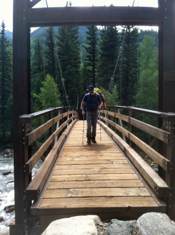 As the first train trundled through Needleton, I passed the rusty truck body and made my way past the cabins to the bridge. I crossed the bridge, very happy to be down and took a spot track side to wait for the next train and the hope of a hot lunch. Twenty minutes later, the next train stopped and after letting everyone off, the Conductor told us that it was fine if we rode up to Silverton and back to Durango as well. We rode into Silverton, having each had a beer en route, and very much looking forward to a hot lunch. Then G and Bob wandered around town a bit as I hobbled along 25 feet, 50 feet, 100 feet, working hard on the promise of a hot chocolate if I could just make it another block. I got to the coffee shop and let me assure you, hot chocolate in hand, I was more than ready catch the train to Durango and the promise of an end to the back country portion of the trip. As the first train trundled through Needleton, I passed the rusty truck body and made my way past the cabins to the bridge. I crossed the bridge, very happy to be down and took a spot track side to wait for the next train and the hope of a hot lunch. Twenty minutes later, the next train stopped and after letting everyone off, the Conductor told us that it was fine if we rode up to Silverton and back to Durango as well. We rode into Silverton, having each had a beer en route, and very much looking forward to a hot lunch. Then G and Bob wandered around town a bit as I hobbled along 25 feet, 50 feet, 100 feet, working hard on the promise of a hot chocolate if I could just make it another block. I got to the coffee shop and let me assure you, hot chocolate in hand, I was more than ready catch the train to Durango and the promise of an end to the back country portion of the trip.
Durango offered a great dinner and a Walgreens where I bought an ankle brace. We got a room and I iced the ankle some more that evening and the following morning. Our plan for the next day was Ouray, the hot springs, and catching up on some more decent eats. We accomplished that goal and early the following morning made our way to the 2WD trailhead for Sneffels from which G and Bob made a climb of Teakettle while I waited at the car. They scored another summit, I read and iced, and then we headed for Cheyenne, getting home at about 8:30 that evening.
Epilogue . . .
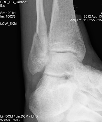 We got home late on Saturday night and I spent Sunday on the couch with a bag of ice on the ankle. I called the doctor on Monday morning, described the injury and had a appointment to get the ankle x-rayed one half hour later. The doctor visit followed a few hours later at which time he read the films and examined the foot to declare that my distal fibula was fractured but stable. He was curious as to the age of the injury and a bit amused when told that it was six days old and that I'd walked out the better part of 8 miles and 3000 vertical on it. Thankfully it was a stable fracture. The foot was in a boot for four weeks and the promise of completing the Centennials was gone for the year . . . as was any opportunity to make those September hikes through the aspen groves that make Fall climbing the best season in the Colorado high country. We got home late on Saturday night and I spent Sunday on the couch with a bag of ice on the ankle. I called the doctor on Monday morning, described the injury and had a appointment to get the ankle x-rayed one half hour later. The doctor visit followed a few hours later at which time he read the films and examined the foot to declare that my distal fibula was fractured but stable. He was curious as to the age of the injury and a bit amused when told that it was six days old and that I'd walked out the better part of 8 miles and 3000 vertical on it. Thankfully it was a stable fracture. The foot was in a boot for four weeks and the promise of completing the Centennials was gone for the year . . . as was any opportunity to make those September hikes through the aspen groves that make Fall climbing the best season in the Colorado high country.
Regardless, I close with the remark that even though we missed Pigeon, Turret and Jagged, I think we all had a good time, G finished the 14'ers and they both picked up the summit of Teakettle, one of the harder Centennials. G and Bob proved their mettle as climbing partners and have my thanks for bearing too much weight on the way out. All in all . . . but for one mishap . . . had a good trip and we now know where we will be going back to and how to (or not to) get there!
|

