-
Mt. Bierstadt Group Summit - Front Range, Colorado
-
A rest before the summit push on Dallas Peak - San Juan Range, Colorado
-
Broken Ankle + 6 Miles = Tired
-
The classic San Juan approach - San Juan Range, Colorado
-
Overlooking Noname Basin from Twin Thumbs Pass - San Juan Range, Colorado
-
Upper Noname Basin - San Juan Range, Colorado
-
Nearing Noname Cabin - San Juan Range, Colorado
-
Twin Thumbs Twins - San Juan Range, Colorado
-
Nearing the summit of Pt. 13,736 - Sawatch Range, Colorado
-
Blustery day on Iowa Peak - Sawatch Range, Colorado
-
Morning snow at 15k, Cerro Ramada - Cordillera Ramada
-
Artesonraju from the summit of Nevado Pisco - Cordillera Blanca, Peru
-
February crowds on Gray's Peak - Front Range, Colorado
-
Kicking steps on Cerro Lliani - Cordillera Vilcanota, Peru
-
Final traverse to the summit of Wheeler Mountain - Ten Mile Range, Colorado
-
The long walk to Pachanta - Cordillera Vilcanota, Peru
- banner31
Afternoon at 17k on Cerro Ramada - Cordillera Ramada, Argentina
- banner22
The final ridge on Iowa Peak - Sawatch Range, Colorado
-
Summer summit on Longs Peak - Front Range, Colorado
-
A rest day at the Pachanta Hot Springs - Cordillera Vilcanota, Peru
-
Mind over matter on Mt. Parnassas - Front Range, Colorado
-
Rest stop on Cerro Lliani - Cordillera Vilcanota, Peru
- banner30
Post nap surprise on Cerro Ramada - Cordiller Ramada, Argentina
-
Summit on Cerro Lliani - Cordillera Vilcanota, Peru
- banner23
Ridge walking on Grizzly Peak - Sawatch Range, Colorado
-
Enroute the summit via the West Ridge on Pacific Peak - Ten Mile Range, Colorado
-
Mule train bound for Chilca - Cordillera Vilcanota, Peru
-
Taking in the view from Fletcher Peak - Ten Mile Range, Colorado
-
Hiking on Silverheels - Mosquito Range, Colorado
-
Traversing! Gladstone Peak - San Juan Range, Colorado
- banner24
The best of times at Willow Lake - Sangre de Christo Range, Colorado
- banner29
High Altitude Cerebral Edema? - Cordillera Ramada, Argentina
-
Bound for Chilca - Vilcanota Range, Peru
-
Going alpine light, Holy Cross Ridge - Sawatch Range, Colorado
-
Cumbre! Campa I - Cordillera Vilcanota, Peru
-
Roadside lunch with the best of company - Cordillera Vilcanota, Peru
- banner25
Long ridge walk to the summit of California Peak - Sangre de Christo Range, Colorado
- banner28
Crossing el Rio Colorado . . . in the afternoon - Cordillera Ramada, Argentina
- banner37
Dealing with Fall snows high on Casco Peak - Sawatch Range, Colorado
-
Moonrise over Mercedario - Cordillera Ramada, Argentina
-
Still climbing at 20,900 on Cerro Ramada - Cordiller Ramada, Argentina
-
Talus on Halo Ridge, Mt. of the Holy Cross - Sawatch Range, Colorado
- banner26
Deteriorating conditions on Mt. Arkansas - Ten Mile Range, Colorado
- banner27
After the climb - Cordillera Ramada, Argentina
- banner38
Taking in the view from the summit of Crystal Peak - Tenmile Range, Colorado
-
Topping out on Mt. Arkansas' North Couloir - Mosquito Range, Colorado
-
Glissade on Mt. Arkansas - Mosquito Range, Colorado
-
Hard snow morning on Teakettle Mountain - San Juan Range, Colorado
-
Spring snow announces the start of the climb on Dallas Peak - San Juan Range, Colorado
-
Crossing the Eolus Catwalk - San Juan Range, Colorado

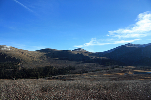
 I got a late start from Cheyenne and arrived at Guanella Pass at about 8 in the morning. Worry not, I thought to myself as it is October and there was not a hint of any need for an alpine start. I left the truck, carrying a prudent minimum light pack and looking forward to a 6 mile solo trip to the summit and back. I took the regular trail to the last rise above Scott Gomer Creek and then cut up creek, connecting hummocks to avoid the bogs and aiming for the trees at the base of the climb proper. The bog that I did have to crosss was still a bit frozen so I managed the traverse with my feet dry, not a bad stunt through this particular piece of terrain.
 I scored a strong trail on the far side, which I knew was there from prior descents from Evans, Spaulding and the Sawtooth. Not wishing to re-invent the route, I took the trail up through the trees, avoiding dead fall here and there and eventually breaking the short cliff band that rises just beyond a small lake perched out of sight above the trees. I was feeling lucky as the weather forecast called for a blustery day but so far there was not a hint of wind. I set a general course upward figuring to break the visible ridge line and then moving up ridge to the summit. The last of the willows had petered out as had the trail that I'd come up on, but no matter, nothing but a gentle rise to the skyline.
 Breaking the ridge left me looking at the hump in front of me and another one far off in the distance. Ordinarily, I would just pull out the map but not today as I'd left it on the arm of the sofa as I packed for the next day's climb. But I did have the right map for a climb of Tweeto . . . the other peak I contemplated climbing . . . really helpful. Regardless, when in doubt, climb the closest summit and then skip the other unless it is higher, that's my theory. Actually, I'd pretty much memorized the map but as I learned the summit of Gray Wolf is a bit deceptive, not seeming high enough compared to Spaulding, but ending up plenty high at the end.
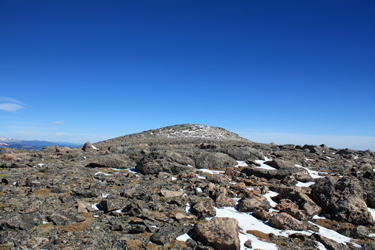 Rather than going left to the ridge, I decided to make a climbing traverse of the face, connecting paths of easy grade until I had to climb a bit of talus. I'll admit to babying the foot, taking it easy and as the MD said . . . "not doing anything stupid." I hopped a bit of talus to score the summit and found that I was not there yet and that yes, this peak was as high as Spaulding, especially as I had to cross a short flat and then climb another mound to officially summit. At that point, the wind came up, bringing the cold with it and sapping any desire on my part to spend any more time on top than needed for a photo and the usual offering. I snapped my usual solo summit shot of the pack and hiking poles, left the single gummy bear for Pachamama and then started down.
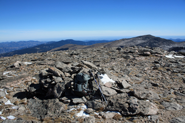 I made a rather direct line from the summit down to the upper most reach of the gully that separates Gray Wolf from Spaulding. I avoided the bottom proper, staying far enough on the flank to ensure no boggy ground. Soon enough, I was back at the short cliff band and the solid trail that cuts through the draw above the perched lake and then onward to the willows. I knew that this trail could peter out in the willows and it did just that when I was opposite the big lake not that far down from the car park. I took a few game trails, crossed one bog using the "think light" method, and was soon enough on the Bierstadt trail and headed for the truck. Overall about a 5 1/2 hour round trip and a bit of a tired foot, but still on the upswing for sure.
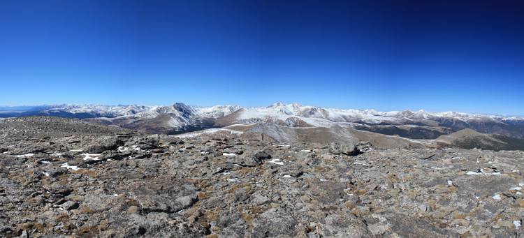