-
Mt. Bierstadt Group Summit - Front Range, Colorado
-
A rest before the summit push on Dallas Peak - San Juan Range, Colorado
-
Broken Ankle + 6 Miles = Tired
-
The classic San Juan approach - San Juan Range, Colorado
-
Overlooking Noname Basin from Twin Thumbs Pass - San Juan Range, Colorado
-
Upper Noname Basin - San Juan Range, Colorado
-
Nearing Noname Cabin - San Juan Range, Colorado
-
Twin Thumbs Twins - San Juan Range, Colorado
-
Nearing the summit of Pt. 13,736 - Sawatch Range, Colorado
-
Blustery day on Iowa Peak - Sawatch Range, Colorado
-
Morning snow at 15k, Cerro Ramada - Cordillera Ramada
-
Artesonraju from the summit of Nevado Pisco - Cordillera Blanca, Peru
-
February crowds on Gray's Peak - Front Range, Colorado
-
Kicking steps on Cerro Lliani - Cordillera Vilcanota, Peru
-
Final traverse to the summit of Wheeler Mountain - Ten Mile Range, Colorado
-
The long walk to Pachanta - Cordillera Vilcanota, Peru
- banner31
Afternoon at 17k on Cerro Ramada - Cordillera Ramada, Argentina
- banner22
The final ridge on Iowa Peak - Sawatch Range, Colorado
-
Summer summit on Longs Peak - Front Range, Colorado
-
A rest day at the Pachanta Hot Springs - Cordillera Vilcanota, Peru
-
Mind over matter on Mt. Parnassas - Front Range, Colorado
-
Rest stop on Cerro Lliani - Cordillera Vilcanota, Peru
- banner30
Post nap surprise on Cerro Ramada - Cordiller Ramada, Argentina
-
Summit on Cerro Lliani - Cordillera Vilcanota, Peru
- banner23
Ridge walking on Grizzly Peak - Sawatch Range, Colorado
-
Enroute the summit via the West Ridge on Pacific Peak - Ten Mile Range, Colorado
-
Mule train bound for Chilca - Cordillera Vilcanota, Peru
-
Taking in the view from Fletcher Peak - Ten Mile Range, Colorado
-
Hiking on Silverheels - Mosquito Range, Colorado
-
Traversing! Gladstone Peak - San Juan Range, Colorado
- banner24
The best of times at Willow Lake - Sangre de Christo Range, Colorado
- banner29
High Altitude Cerebral Edema? - Cordillera Ramada, Argentina
-
Bound for Chilca - Vilcanota Range, Peru
-
Going alpine light, Holy Cross Ridge - Sawatch Range, Colorado
-
Cumbre! Campa I - Cordillera Vilcanota, Peru
-
Roadside lunch with the best of company - Cordillera Vilcanota, Peru
- banner25
Long ridge walk to the summit of California Peak - Sangre de Christo Range, Colorado
- banner28
Crossing el Rio Colorado . . . in the afternoon - Cordillera Ramada, Argentina
- banner37
Dealing with Fall snows high on Casco Peak - Sawatch Range, Colorado
-
Moonrise over Mercedario - Cordillera Ramada, Argentina
-
Still climbing at 20,900 on Cerro Ramada - Cordiller Ramada, Argentina
-
Talus on Halo Ridge, Mt. of the Holy Cross - Sawatch Range, Colorado
- banner26
Deteriorating conditions on Mt. Arkansas - Ten Mile Range, Colorado
- banner27
After the climb - Cordillera Ramada, Argentina
- banner38
Taking in the view from the summit of Crystal Peak - Tenmile Range, Colorado
-
Topping out on Mt. Arkansas' North Couloir - Mosquito Range, Colorado
-
Glissade on Mt. Arkansas - Mosquito Range, Colorado
-
Hard snow morning on Teakettle Mountain - San Juan Range, Colorado
-
Spring snow announces the start of the climb on Dallas Peak - San Juan Range, Colorado
-
Crossing the Eolus Catwalk - San Juan Range, Colorado

 The trail started as a two-rut vehicle track but soon turned to a single walking path heading up creek. Not far above tree line, I climbed over a dam of avalanche debris, snow, rock, and small trees, deposited into the creek bed from the large avalanche run coming down the western flank of Sunshine Peak. On up the valley the trail winds and eventually I arrived at the elevation 13,020 saddle below the north shoulder of Redcloud Peak. I rested at the saddle and watched a fox attempting to catch a pika amongst the rocks. Given the amount of fur filled scat on the trail, I think the fox had a good batting average in his game.
  It was early in the season but there was little snow left on the peak below the 13,000-foot level. However, there was snow to climb starting just above the saddle and it sure looked better than the scree covered switchbacks leading to the false summit of Redcloud. I made my way up the snow to the false summit and then walked dry trail to the true top of Redcloud Peak. From the summit, the San Juan range lay before me, which was the good news. The bad news was the building thunderstorm over the Weminuche that seemed to be headed my way . . . I still had one summit to go.
  If you have read my other trip reports, I have tried to give honest descriptions of the various stupid or bonehead moves I have managed to commit over the experience of climbing Colorado’s 14’ers. Well . . . as you can guess, I am about to do it again. The storm did not seem to be moving too fast so I set off for Sunshine Peak. The connecting saddle is not a short hop but a good mile hike each way with an appreciable climb down and up in each direction. I got to within about 200 vertical feet of the summit of Sunshine when the storm began to leave no doubt of its next planned stop, Sunshine Peak. Now before you condemn me as a total putz, it is not close yet but the fact that it is coming my way has just become a substantial possibility. I dropped the pack at trailside and made a scramble for the summit, tagged it and got back to my pack. I then set off for the summit of Redcloud once again.
 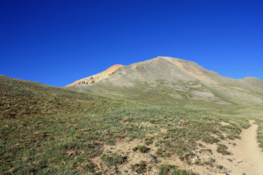 In hindsight, a drop into the gulch and departure via the South Fork of Silver Creek would have been the wisest move but I was not completely sure of the route. The climb up the flank of Sunshine makes its way through a narrow cleft in a cliff band and I was unsure if I would hit the cleft without error when approaching from above the cliff line. I think that I set a record crossing the saddle and soon enough I was headed back down the north shoulder of Redcloud for the saddle below. I made steady time down the trail and made tree line about the time the storm hit, the sky opening up with rain, hail and lightning. As I write this report, I’m almost done the 14’ers but in hindsight, climbing the 14’ers from easy to hard is a great way to become a decent intermediate climber and rack up enough experiences to
 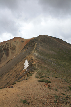 end up marginally mountain smart. This trip provided the lesson of having respect for an approaching storm, even one far away, and the importance of turning a climb before you must consider the possibility of a fast retreat or worse.