|
||||||||||||||
|---|---|---|---|---|---|---|---|---|---|---|---|---|---|---|
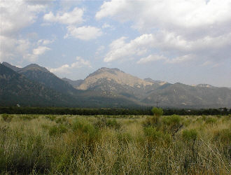
Challenger Point and Kit Carson Peak –Willow Creek and Lake - August 1, 2000
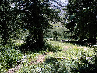
After completing a climb of San Luis Peak, I headed back down to Saguache and across the San Luis Valley to the town of Crestone. I was planning to combine San Luis with an attempt of Kit Carson via the scenic Willow Lake approach but it was late in the day so I opted first for dinner in Alamosa. After a decent feed, I went back to Crestone and camped for the night at the forest service campground just north of town. The next day I drove to the trailhead on the edge of the Baca and started the trek toward Willow Lake. The trail began with a series of switchbacks reminiscent of what for me are the “switchbacks from hell” that lead up into the basin below Belford and Missouri Mountains. Once atop the back and forth climb, I passed the large open meadow, noted on the map, and then climbed up the headwall into the upper part of the valley. From a distance, I questioned how the trail would surmount this headwall but the path took another switch backing route and soon enough I had covered the miles to Willow Lake.
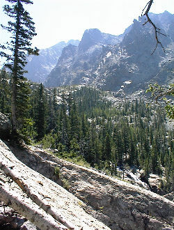
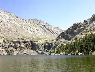
Willow Lake lies in a hanging valley and is fed by a small stream draining the northern flanks of Challenger and Kit Carson Peaks. I camped in the designated area below the lake outfall and was joined by bighorns and scurrying white weasels, a mountain animal I had never seen on a climb before. I settled in for the afternoon with a decent book, ate dinner, hung the food in a tree and awaited nightfall.
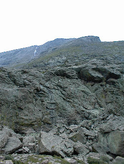
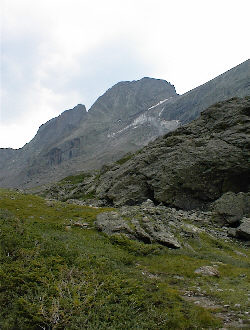
The next morning, I left at daybreak and took the trail around the north shore of the lake to the upper valley. My plan was to first climb the northern flank of Challenger Point and then, depending on the difficulty of the crossing to Kit Carson, make the connection and score both peaks in one day. The climb up Challenger was over big talus, washing machine size rock, similar to the summit cone on Pike’s Crags route and I kept close to the eastern edge, as that route appeared to be the easiest ascent to the Challenger Ridge. The route turned out to be a scramble, rather than a hike, and route finding was required for most of the way, as the climb was not cairned. Toward the top, the terrain was solid class 3 climbing but I eventually reached the ridgeline and started toward the Point proper. Once atop the ridge, I round a trail but perhaps half way down the ridge to the point, I followed the trail over the ridge to the Baca side. This turned out to be a bad move because as I went on the trail petered out and the terrain went from Class 3, to 4 and then 5+ along the steepening west side of the ridge.
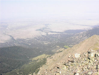
I realized I had made a bust in route finding and backtracked to my cross over point to find the right path to the Point. I found the route and made my way to Challenger Point, which provides a great view of the Baca and the San Luis Valley below. Adjacent to Challenger Point, is Kit Carson Peak, which is reached via the well-known Kit Carson Avenue. I walked down the flank of Challenger Point to the saddle that connects with Carson and forms the top of the Kirk Couloir. Then it is up an obvious trail and through a gap onto the Avenue, which was not what I expected of a ledge. It might be more appropriately called a highway, fully ten or more feet wide and steadily descending as it leads around Carson’s south face to the couloir one has to climb to gain the summit. The break left for the couloir climb was fairly obvious, perhaps due to a piece of flagging that caught my eye and the occasional cairns that mark the route up through the loose, typical Crestones type couloir climb.
The couloir led to a scrambling ridge traverse to the summit where I met two other climbers but did not spend much time there as the sky was clouding up. I retraced my climb down the couloir, caught the cut off for the Carson ledge, a turn that might not be completely obvious to all but if missed will lead one down the flank of Carson instead of up the Avenue toward Challenger. Once back at the top of the Kirk Couloir, I spoke to another climber who was considering a descent down the couloir. I noted the obvious blue ice and steep slopes and asked if he had an ice axe. He did not and I gave my opinion of what should have been obvious, that his life expectancy for such a descent would be measured in seconds rather than minutes. I did not stick around to witness his decision but did get to talk to him later at the Lake, where he related that the slope did in fact look a bit on the dicey side. Good decision on his part.
I skirted the north side of Challenger Point, making my way back in the direction I had ascended. Rather than down climb my ascent route, I chose a rocky couloir, which appeared to provide a Class 3 downclimb to the valley below. My choice was correct and I was pleased with my read of the topography though it was a descending scramble almost the entire way. Once I neared the valley floor, I intersected the lower climber’s trail and took that route to the creek and on down to my camp.
I gave some thought to overnighting again at Willow Lake but it was still early in the afternoon, so I broke camp and headed for the truck. The route out was long and my feet were killing me by the time I stopped to look down onto into the large meadow near the top of the switchbacks. However, like the Belford switchbacks, these too were indicative of nearing trail’s end and that means the boots would come off soon enough. I enjoyed the climb of Challenger Point and Carson Peak from the Willow creek drainage, having seen the traditional route during an earlier climb of Humboldt Peak. Something about those false summits just did not pull at my heartstrings and the opportunity to see weasels and bighorn sheep in camp made the trip even more worthwhile.
|
