Dallas Peak
May 5, 2012 - East Face Classic - Attempt
For three years, Ed and I have taken the first weekend of May as a long weekend to climb peaks that are more distant from Cheyenne. The program started out as a way for Ed to have a partner for some of the harder 14'ers, which I had completed but was willing to repeat. Now he is almost done with the 14'ers and we have changed the plan to cover harder 13'ers that we both want to climb. This weekend's plan was a true turbo trip, a Friday morning departure from Cheyenne, a climb of Dallas and Teakettle, and an arrival home on Sunday night.
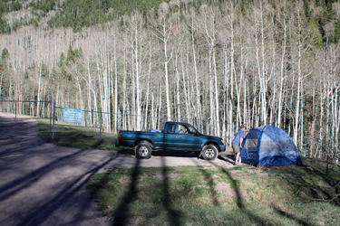 I left Cheyenne at 8:00 a.m. and after picking Ed up in Thornton, we were San Juans bound at 10 a.m. and arrived in Telluride at a bit after 5 p.m. Our immediate goals were finding the trailhead, finding a camp spot and finding dinner . . . in that order. We found the trailhead with ease and were happy to find that it was open, dry and featured a flat spot right next to the gate of the Telluride water treatment plant. We had dispensed with both the trailhead and camp spot locating need, the tent was up and we were on our way to town for dinner. Telluride was more than a bit sleepy in the 'tween season so we headed to a place we had eaten at the summer before when we did the Wilsons. The food was mediocre at best, the crowd was beautiful and hip (grain of salt . . .) but the fare fit the bill enough to fuel the following day's climbing effort. I left Cheyenne at 8:00 a.m. and after picking Ed up in Thornton, we were San Juans bound at 10 a.m. and arrived in Telluride at a bit after 5 p.m. Our immediate goals were finding the trailhead, finding a camp spot and finding dinner . . . in that order. We found the trailhead with ease and were happy to find that it was open, dry and featured a flat spot right next to the gate of the Telluride water treatment plant. We had dispensed with both the trailhead and camp spot locating need, the tent was up and we were on our way to town for dinner. Telluride was more than a bit sleepy in the 'tween season so we headed to a place we had eaten at the summer before when we did the Wilsons. The food was mediocre at best, the crowd was beautiful and hip (grain of salt . . .) but the fare fit the bill enough to fuel the following day's climbing effort.
 We planned to take the standard route on Dallas but we were unsure where the snow line would be, i.e. how much pre dawn route finding we'd be stuck with before we got out of the trees and into the light of day. We had to get an early start as we wanted enough time to make the summit climb and that meant bringing the rope, protection, and slowing the climb down a bit due to the extra weight on our backs. We climbed Sneffels the year before on the same weekend and figured that if we had a long snowy approach, we would be on snow shoes and struggling with posthole hell all the way out. Accordingly, we left the campsite at 3 a.m. We planned to take the standard route on Dallas but we were unsure where the snow line would be, i.e. how much pre dawn route finding we'd be stuck with before we got out of the trees and into the light of day. We had to get an early start as we wanted enough time to make the summit climb and that meant bringing the rope, protection, and slowing the climb down a bit due to the extra weight on our backs. We climbed Sneffels the year before on the same weekend and figured that if we had a long snowy approach, we would be on snow shoes and struggling with posthole hell all the way out. Accordingly, we left the campsite at 3 a.m.
 The trail was thankfully clear of snow for the first half mile and we arrived at the first well signed junction and turned left to head for the eventual connection to the Sneffels Highline trail. The meadow mentioned in the guidebook was traversed in the dark and then we met our first snow. The trail was covered but the tree cut was obvious and the coverage was in fact only about 200 yards long and well tracked by prior hikers. No doubt as to the route and after just a few few minutes we were on clear trail once again. We next came to the Highline trail junction, still very much in the dark but recognizable by the signs. The next segment was the series of switchbacks that would take us nearly to tree line and deal us our first frustration of the day. The trail was thankfully clear of snow for the first half mile and we arrived at the first well signed junction and turned left to head for the eventual connection to the Sneffels Highline trail. The meadow mentioned in the guidebook was traversed in the dark and then we met our first snow. The trail was covered but the tree cut was obvious and the coverage was in fact only about 200 yards long and well tracked by prior hikers. No doubt as to the route and after just a few few minutes we were on clear trail once again. We next came to the Highline trail junction, still very much in the dark but recognizable by the signs. The next segment was the series of switchbacks that would take us nearly to tree line and deal us our first frustration of the day.
 All the switchbacks but the last one were clear, the last one was covered in snow, about 18" deep and we went past the cut back by perhaps 100 feet before coming to the solid conclusion we had missed a turn. We have both climbed enough to know where the trail ought to be and we were not where our minds were telling us that we wanted to be. We turned the headlamps to high, painted the woods and had no luck at spotting the tree cut. So, we simply turned 180 degrees and went back 50 yards and cut up slope, figuring to cut the trail if we were lucky. We were lucky and cut a brief segment of dry trail that gave us the contour we needed to follow in order to pick up the trail on the correct side of the hill. We got our trail and at the same time, our light, all just about 15 minutes too late to avoid the initial frustration. All the switchbacks but the last one were clear, the last one was covered in snow, about 18" deep and we went past the cut back by perhaps 100 feet before coming to the solid conclusion we had missed a turn. We have both climbed enough to know where the trail ought to be and we were not where our minds were telling us that we wanted to be. We turned the headlamps to high, painted the woods and had no luck at spotting the tree cut. So, we simply turned 180 degrees and went back 50 yards and cut up slope, figuring to cut the trail if we were lucky. We were lucky and cut a brief segment of dry trail that gave us the contour we needed to follow in order to pick up the trail on the correct side of the hill. We got our trail and at the same time, our light, all just about 15 minutes too late to avoid the initial frustration.
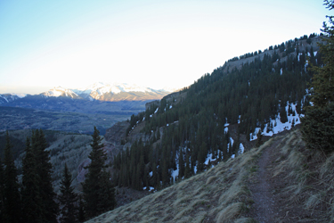
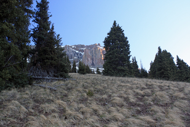
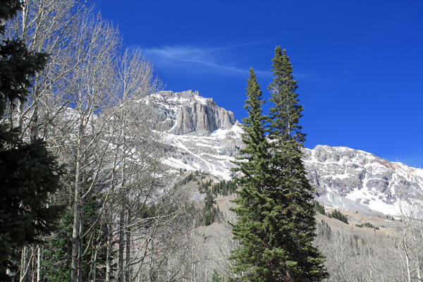
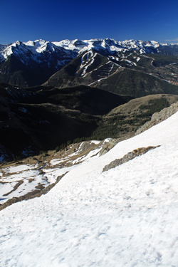 We skirted the hill and came into the valley that lies below "West Dallas" and the last trees of the route. Unfortunately, this last area of trees held some great puffy pillow soft snow, pillows that took us in to the waist in more than a few spots. The stretch is not long, perhaps 200 yards at most, but it beat us up the right way as there was no way to spot the route and keep from wading. We simply held our contour and figured to fight to the bare slopes on the far side of the shallow draw where we knew we could regain the trial. The trail was soon in hand again and we hiked for 10 or 15 minutes around the nose shown on the map in search for the grassy slope spoken of in the Roach guide. The grassy slope proved to be obvious so we left the trail to climb the couple hundred feet of vertical We skirted the hill and came into the valley that lies below "West Dallas" and the last trees of the route. Unfortunately, this last area of trees held some great puffy pillow soft snow, pillows that took us in to the waist in more than a few spots. The stretch is not long, perhaps 200 yards at most, but it beat us up the right way as there was no way to spot the route and keep from wading. We simply held our contour and figured to fight to the bare slopes on the far side of the shallow draw where we knew we could regain the trial. The trail was soon in hand again and we hiked for 10 or 15 minutes around the nose shown on the map in search for the grassy slope spoken of in the Roach guide. The grassy slope proved to be obvious so we left the trail to climb the couple hundred feet of vertical 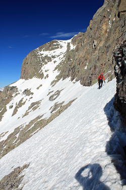 needed to get to the basin from which the climb would start in earnest. needed to get to the basin from which the climb would start in earnest.
The basin was mostly full of snow and we cut for a shallow couloir that would get us up and through the first cliff band. The traverse from the top of the grassy slope to the start of the couloir was about 1/2 mile at most and then we were moving upward. The slope is steep enough to justify an axe so we made the switch knowing that the next segment of the climb would involve crossing side slopes until we transited the next rib. The snow was hard neve and once we got to the top, we side hilled to the next rib, negotiating a 45 degree slope on points alone, it was time to be a bit more cautious as to our foot placements. The first rib placed us at the top of a cliff and at the start of another snowfield traverse to the next rib.
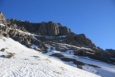
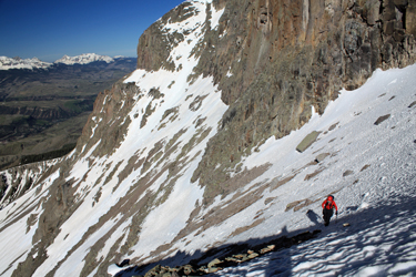 The second rib put us on the east face, a bit of a mazy area of pinnacles that we crossed looking for the route west that should place us at the summit tower. We passed a direct route to the tower that would have allowed a diversion from the described route and in hindsight let us skip a section of rock climb that proved a bit time consuming in crampons. We stuck to the program and gained the top of the cliff band on class 3 rock, made a bit tougher by the crampons, but we were now within reach of the summit tower. Our next move was to gain about 100 more vertical feet and slip up through a slot adjacent to the one holding the chock stone. The route up was class 4, even with the snow, but it did place us where we needed to be, at the top of the chock and ready to move onto the north face. The second rib put us on the east face, a bit of a mazy area of pinnacles that we crossed looking for the route west that should place us at the summit tower. We passed a direct route to the tower that would have allowed a diversion from the described route and in hindsight let us skip a section of rock climb that proved a bit time consuming in crampons. We stuck to the program and gained the top of the cliff band on class 3 rock, made a bit tougher by the crampons, but we were now within reach of the summit tower. Our next move was to gain about 100 more vertical feet and slip up through a slot adjacent to the one holding the chock stone. The route up was class 4, even with the snow, but it did place us where we needed to be, at the top of the chock and ready to move onto the north face.
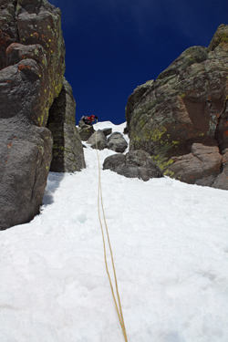
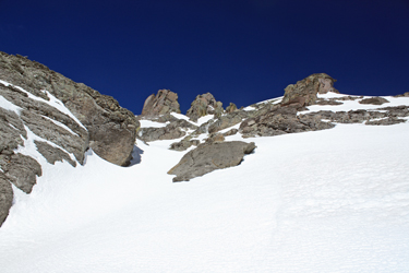 Well, not on this climb . . . the move to the north face was there for the taking, all nicely covered with snow, tough to protect, showing signs of a bit of ice, and lots of opportunity to make ne of those eternity moves to the valley below. I've got 160 14'ers and 13'ers under my belt and my alarm bells were ringing, that uncomfortable feeling was there, that sense of not the right time nor the right place. I told Ed that my climb had just concluded and that the summit would have to wait for another day. Ed was of like mind, so we shot a Gu and went back to the top of the pitch that placed us at our present locale. I didn't like the look of the climb down, so i rigged the rope for a fast rappel, which placed us both on the more mellow slope Well, not on this climb . . . the move to the north face was there for the taking, all nicely covered with snow, tough to protect, showing signs of a bit of ice, and lots of opportunity to make ne of those eternity moves to the valley below. I've got 160 14'ers and 13'ers under my belt and my alarm bells were ringing, that uncomfortable feeling was there, that sense of not the right time nor the right place. I told Ed that my climb had just concluded and that the summit would have to wait for another day. Ed was of like mind, so we shot a Gu and went back to the top of the pitch that placed us at our present locale. I didn't like the look of the climb down, so i rigged the rope for a fast rappel, which placed us both on the more mellow slope 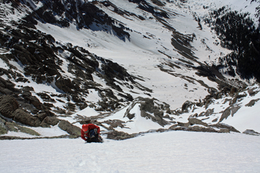 below and to a bit of surprise, sinking in snow to our knees where we had left but point marks one half hour before. below and to a bit of surprise, sinking in snow to our knees where we had left but point marks one half hour before.
We were at 13,700 with the promise of post holes on a bunch of side slopes, just my idea of a fun way to come off a mountain. Fortunately for us, we had just found a soft spot and the slope below was still hard enough to descend on the heels and descend we did. I opted not to repeat the rock band but instead chose the direct descent down through the draw that caught my attention as we climbed. Heel after 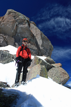 heel allowed me to cut our ascent trail in just a few minutes and then we were off to traverse the slopes down along the top of the cliff bands, across the smaller ridges and to the top of the draw that cut the first cliff band. Our descent of the last couloir was quickened by a glissade that left me wet of butt but glad of velocity. We were soon off the snow and hiking back down the grassy slope to cut the trail and headed back for the snow of the woods. heel allowed me to cut our ascent trail in just a few minutes and then we were off to traverse the slopes down along the top of the cliff bands, across the smaller ridges and to the top of the draw that cut the first cliff band. Our descent of the last couloir was quickened by a glissade that left me wet of butt but glad of velocity. We were soon off the snow and hiking back down the grassy slope to cut the trail and headed back for the snow of the woods.
 I was dreading the 200 yard hike through the woods to the next section of open trail because I'd gone in up to my waist right after dawn . . . it was now 2 p.m. and I knew I was about to take a beating. I thought the lightest of thoughts, I used my poles to spread my weight, and I told myself it was going to be over with sooner and then we would just walk out on dry trail. All that was true, but I still had to just about swim one stretch of the passage through the trees. I did however spot a marker cliff and, once I was I was dreading the 200 yard hike through the woods to the next section of open trail because I'd gone in up to my waist right after dawn . . . it was now 2 p.m. and I knew I was about to take a beating. I thought the lightest of thoughts, I used my poles to spread my weight, and I told myself it was going to be over with sooner and then we would just walk out on dry trail. All that was true, but I still had to just about swim one stretch of the passage through the trees. I did however spot a marker cliff and, once I was 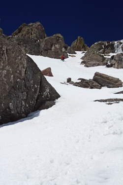 standing on dry trail, I yelled out to Ed that there was hope after all and that I had found it in the form of dirt under foot. standing on dry trail, I yelled out to Ed that there was hope after all and that I had found it in the form of dirt under foot.
We hiked the remaining 2.5 miles or so without incident, passing folks enjoying spring flowers and asking if we had summitted. We told them it was one of those close but no cigar climbs and kept moving along with determination. We hit the truck at 4 pm. and soon had the tent down and were on our way. Why the hurry . . . well the food is better in Ouray and even better, this 51 year old body needed a good hot soak in the pool as our schedule called for an early start the next morning in hope of summitting Teakettle Mountain, the next Centennial on our list.
|
