Grizzly Peak
July 25, 2010 - McNasser Gulch
Bob and I tried to summit Grizzly Peak via the Grizzly Couloir snow climb at the start of June but failed due to lousy snow conditions brought on by warm overnight temps. We ended up post holing in the snow, up to our bums and finally gave up about a half mile from the start of the couloir. We knew that we'd have been bushed when we got to the climb proper and that if the snow was that bad on the approach, we really didn't need to be testing a possibly tender slope with nothing else to do that day but bury a couple of fools who should ahve known better.
 For this trip, the couloir was clearly not an option as I had no interest in climbing up through a ragged shooting gallery of summer scree possibly highlighted by some patches of summer ice. The alternate western side offered nothing of interest as I knew it was steep and I again had no interest in a steep and endless scree slog. This left the NcNasser Gulch approach to the east ridge of the peak, a route that would also have scree but beyond which promised what I'd heard was a good ridge traverse as well as the opportunity to check out a new drainage I'd never ventured into before. For this trip, the couloir was clearly not an option as I had no interest in climbing up through a ragged shooting gallery of summer scree possibly highlighted by some patches of summer ice. The alternate western side offered nothing of interest as I knew it was steep and I again had no interest in a steep and endless scree slog. This left the NcNasser Gulch approach to the east ridge of the peak, a route that would also have scree but beyond which promised what I'd heard was a good ridge traverse as well as the opportunity to check out a new drainage I'd never ventured into before.
 We left Cheyenne when Bob got off on Saturday afternoon and made it to Leadville by about 10 p.m. The weather forecast had been talking of evening storms with possible heavy downpours but those storms had fully cleared out before our arrival. We bought some trail food and drink at the Safeway and then were off to camp at the campground flats above Clear Lake on the road to Winfield. I figured there might be commando spots near the McNasser Gulch road and trail head but it was late and I just didn't feel like hunting them up in the dark. Given that it was mid July, the thought of a USFS camp spot along the Independence Pass road seemed pointless, so we didn't even bother looking. We left Cheyenne when Bob got off on Saturday afternoon and made it to Leadville by about 10 p.m. The weather forecast had been talking of evening storms with possible heavy downpours but those storms had fully cleared out before our arrival. We bought some trail food and drink at the Safeway and then were off to camp at the campground flats above Clear Lake on the road to Winfield. I figured there might be commando spots near the McNasser Gulch road and trail head but it was late and I just didn't feel like hunting them up in the dark. Given that it was mid July, the thought of a USFS camp spot along the Independence Pass road seemed pointless, so we didn't even bother looking.
 We made it to the Clear Lake Camp and had the tent up by 11 p.m. amid the gentle din of campers settling in for the night. This is not campground with any degree of formality but simply a big flat spot with seemingly no sites in particular. Just a pull in and pitch the tent in some spot that seems not to invade the space of anyone nearby. Its easy, free and offered just what I wanted . . . a place to sleep for six hours until we awoke, struck the tent and moved out in the direction of McNasser Gulch. We made it to the Clear Lake Camp and had the tent up by 11 p.m. amid the gentle din of campers settling in for the night. This is not campground with any degree of formality but simply a big flat spot with seemingly no sites in particular. Just a pull in and pitch the tent in some spot that seems not to invade the space of anyone nearby. Its easy, free and offered just what I wanted . . . a place to sleep for six hours until we awoke, struck the tent and moved out in the direction of McNasser Gulch.
The alarm went off on time and by 5:20 a.m. we were driving along Clear Lake and almost to the main highway. We headed north a bit, 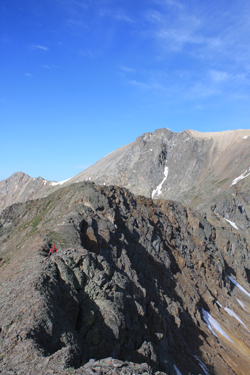 passing through the hamlet of Granite, and then were off on Colorado 82 toward Twin Lakes and the trail head for La Plata Peak. There were already 8 or 10 cars in the La Plata parking lot and, given good weather, clearly there were some folks looking to bag a 14'er on what, so far, was a beautiful day. We took the dirt track on past the La Plata registration point and through another mile and a half of private land passing through the hamlet of Granite, and then were off on Colorado 82 toward Twin Lakes and the trail head for La Plata Peak. There were already 8 or 10 cars in the La Plata parking lot and, given good weather, clearly there were some folks looking to bag a 14'er on what, so far, was a beautiful day. We took the dirt track on past the La Plata registration point and through another mile and a half of private land 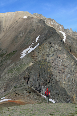 before coming back into the National Forest. We came to and passed through the guide book described junctions and decided to take a shot at the final 1.2 miles of so of 4WD road that would lead to the upper or 4WD trail head for McNasser Gulch. before coming back into the National Forest. We came to and passed through the guide book described junctions and decided to take a shot at the final 1.2 miles of so of 4WD road that would lead to the upper or 4WD trail head for McNasser Gulch.
The 4WD track, but for one 100 foot stretch was no more difficult than the course that lead to that last segment. We drove to the 4WD trail head and parked next to one other vehicle. I swapped duds and we were off toward the peak, albeit at about 6:45 a.m., which we acknowledged was a bit later than desired but the drive up McNasser Gulch took a bit longer than expected. It is not a bad road but that is coming from someone what has done the Colony Lake road in his everyday use and quite stock Toyota Tacoma and not given it much thought. I didn't think the road to the upper trailhead to be all that bad.
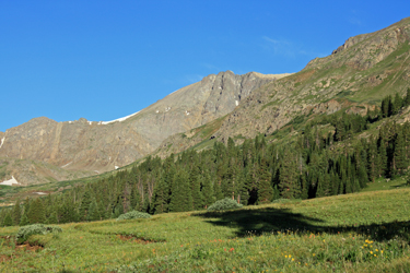
 We walked the old mine road, passing through the quite sturdy gate and then easily followed the road that is degrading to a single track with the passage of time. The course took us through trees along a gentle grade before we broke out into the open and passed an old mine trailer and other gear off to the right side of the track. We hiked on, now through the open, to the mine pad as described in a guidebook. The mine provided a good place to stop, drink a bit and shoot a GU before we took on the next segment of the climb. We walked the old mine road, passing through the quite sturdy gate and then easily followed the road that is degrading to a single track with the passage of time. The course took us through trees along a gentle grade before we broke out into the open and passed an old mine trailer and other gear off to the right side of the track. We hiked on, now through the open, to the mine pad as described in a guidebook. The mine provided a good place to stop, drink a bit and shoot a GU before we took on the next segment of the climb.
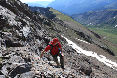
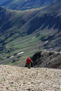 We climbed the bank behind the mine excavation and old portal and I knew from the guide that the route described would take us another half mile up the valley before we turned to the right and started climbing the scree slope to the East Ridge. But . . . to our immediate right was a sedate grassy slope that seemed to offer a course of lesser grade and the opportunity to walk the ridge line for an extra half mile in lieu of the valley. I'd read a trip report that spoke of a scree battle and the more sedate slopes seemed to offer a better route. We climbed the bank behind the mine excavation and old portal and I knew from the guide that the route described would take us another half mile up the valley before we turned to the right and started climbing the scree slope to the East Ridge. But . . . to our immediate right was a sedate grassy slope that seemed to offer a course of lesser grade and the opportunity to walk the ridge line for an extra half mile in lieu of the valley. I'd read a trip report that spoke of a scree battle and the more sedate slopes seemed to offer a better route.
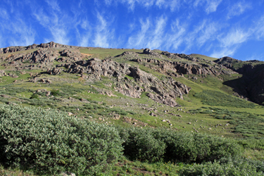
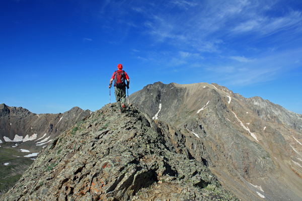
We took on the green slope, splitting our tracks and not following any defined track, until we broke the ridge and looked down into the opposite valley at the now green area that had stopped us dead in our tracks just six weeks before. The trip to the ridge was really not that bad but did consume every bit of an hour as we gained no less than 1000 feet to get the worst of the climb over with. We shot a GU and were off along the ridge that although narrow in spots but offered a really nice ridge walk of the Class 1 to 1+ variety for the whole of its length.
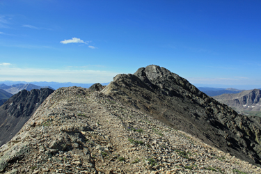 The ridge dipped to the saddle mentioned in the guide book and this was where we each stashed one of the hiking poles in the respective packs and took on the ridge to the sub summit. The ridge was mostly Class 2 to 2+ climbing with some Class 3 routes intentionally selected for the heck of it. Though the ridge looked to be challenge, it provided non technical work arounds to each spot that, from a distance, looked to be a little on the tougher side. The ridge included a number of pinnacles, all of which were skirted on the south side and, after about one half hour of climbing, we started up troughed serpentine trail worn into the lighter colored band of rock that from a distance seemed perched like a buff colored cap on the summit ridge of the peak. The ridge dipped to the saddle mentioned in the guide book and this was where we each stashed one of the hiking poles in the respective packs and took on the ridge to the sub summit. The ridge was mostly Class 2 to 2+ climbing with some Class 3 routes intentionally selected for the heck of it. Though the ridge looked to be challenge, it provided non technical work arounds to each spot that, from a distance, looked to be a little on the tougher side. The ridge included a number of pinnacles, all of which were skirted on the south side and, after about one half hour of climbing, we started up troughed serpentine trail worn into the lighter colored band of rock that from a distance seemed perched like a buff colored cap on the summit ridge of the peak.
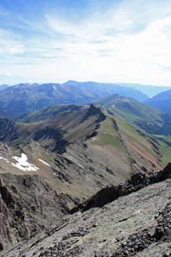 We stepped onto the sub summit and were able to look down the Grizzly Couloir, which was substantively melted out and clearly not in any condition to climb. From the sub summit the route is clearly no more than a traverse along the dirt track to the summit proper and a few Class 2 moves to the high point. We arrived on the summit about 3 hours after leaving the truck, a time that I was content with regardless of the fact that I didn't really find my hiking/climbing groove until we were more than half way up the slopes to the original ridge line. In an unusual move, I sat on the summit for a half hour with Bob who normally must tolerate me hefting my pack at about the 5 minute mark to head for the barn. I'm usually looking to building clouds or some other reason to move out but on this climb, there was no reason, we had a blue sky and it was barely 10 a.m. We stepped onto the sub summit and were able to look down the Grizzly Couloir, which was substantively melted out and clearly not in any condition to climb. From the sub summit the route is clearly no more than a traverse along the dirt track to the summit proper and a few Class 2 moves to the high point. We arrived on the summit about 3 hours after leaving the truck, a time that I was content with regardless of the fact that I didn't really find my hiking/climbing groove until we were more than half way up the slopes to the original ridge line. In an unusual move, I sat on the summit for a half hour with Bob who normally must tolerate me hefting my pack at about the 5 minute mark to head for the barn. I'm usually looking to building clouds or some other reason to move out but on this climb, there was no reason, we had a blue sky and it was barely 10 a.m.
We reversed our route to the sub summit and then on back down the ridge to the low point saddle. Bob was in the lead and instead of taking the ridge back to our ascent point, he made for lower elevation right from the saddle. I followed unsure of whether he had a plan or had wishfully thought himself 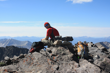 past the need to re climb the first part of the ridge to get down via our ascent route. Regardless, this put us onto the guidebook route and, with just a little thought and route finding, we skirted one cliffy section, made a grassy slope our target and were soon hoofing our way out through the bottom of the valley. We ended up with a climb time of five hours truck to truck, not bad for someone who just couldn't get the groove until having ascended a good 1500 feet. past the need to re climb the first part of the ridge to get down via our ascent route. Regardless, this put us onto the guidebook route and, with just a little thought and route finding, we skirted one cliffy section, made a grassy slope our target and were soon hoofing our way out through the bottom of the valley. We ended up with a climb time of five hours truck to truck, not bad for someone who just couldn't get the groove until having ascended a good 1500 feet.
|
