Rinker Peak
December 2, 2012 -Big Willis Trail
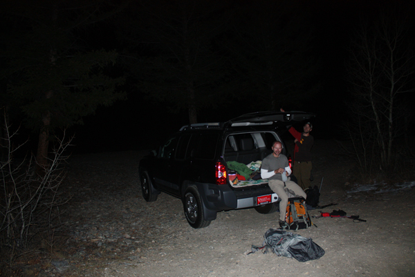
"I don't know how early in the morning I'm good for . . . " texted Calvin. The next morning Bob remarked that a 4 a.m. departure was not what he expected when I said we needed an "alpine start." Bob is more used to the 2 a.m. alpine departure from Cheyenne to arrive in Leadville early enough for a full day. Regardless of the difference of opinion, we were headed south at 4:20 and passing through Leadville three hours later en route to Twin Lakes.
 We did not know what we were going to climb when we left but opted for Rinker via Big Willis Gulch to mostly keep us below the forecast winds. We discussed going for a Grizzly, Carbonate, Cyclone triple play but with the forecast of 45 mph gusts and zero degree wind chills, that ridge jaunt was off the table. We were soon at the Willis Gulch trailhead and headed across the bridge at 8 a.m. sharp, headed downstream in the wrong direction. We ran out of trail after 100 yards and then went back to spot the correct route that circles around the beaver pond before starting to climb. We did not know what we were going to climb when we left but opted for Rinker via Big Willis Gulch to mostly keep us below the forecast winds. We discussed going for a Grizzly, Carbonate, Cyclone triple play but with the forecast of 45 mph gusts and zero degree wind chills, that ridge jaunt was off the table. We were soon at the Willis Gulch trailhead and headed across the bridge at 8 a.m. sharp, headed downstream in the wrong direction. We ran out of trail after 100 yards and then went back to spot the correct route that circles around the beaver pond before starting to climb.
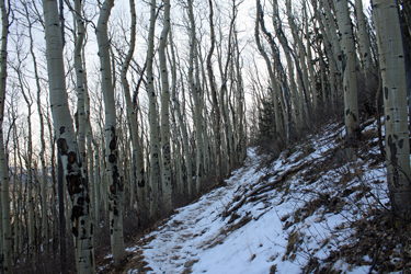
 Every year I try to do at least one trip where I have the route wired and then proceed to screw up every navigational aspect in order to climb the wrong peak or otherwise waste time that could be saved but for a short read of the guidebook or a look at the map in my pocket. This was to be that trip for 2012. Now that we were on the correct trail, we made good time to the first junction and the correct turn uphill (duh) to head for Big WIllis Gulch. The trail snaked its way up through the woods, which were cold and dark this morning. They had an almost Appalachian feel to them, that skiff of snow, the creaking trees and kind of a dark eastern "hollow" feel. I kind of liked it. Every year I try to do at least one trip where I have the route wired and then proceed to screw up every navigational aspect in order to climb the wrong peak or otherwise waste time that could be saved but for a short read of the guidebook or a look at the map in my pocket. This was to be that trip for 2012. Now that we were on the correct trail, we made good time to the first junction and the correct turn uphill (duh) to head for Big WIllis Gulch. The trail snaked its way up through the woods, which were cold and dark this morning. They had an almost Appalachian feel to them, that skiff of snow, the creaking trees and kind of a dark eastern "hollow" feel. I kind of liked it.
 We came to the bridge that crossed Willis Creek so I looked at the map and turned back to look at the slope that in my muddled mind should have held the trail to Big Willis Gulch. Was I reading the map correctly, no . . . the cut off to Big Willis is another mile or so up the valley. Well, my gut told me that the dearth of clear passage on the hill would make any kind of a bushwhack a senseless proposition. But, but, but . . . I'd read another person's trip report about some degree of difficulty in finding the Big Willis cut off so I had it in my mind that I'd better keep a keen eye on the right side of the trail, you know so I could spot the trace in the snow. We came to the bridge that crossed Willis Creek so I looked at the map and turned back to look at the slope that in my muddled mind should have held the trail to Big Willis Gulch. Was I reading the map correctly, no . . . the cut off to Big Willis is another mile or so up the valley. Well, my gut told me that the dearth of clear passage on the hill would make any kind of a bushwhack a senseless proposition. But, but, but . . . I'd read another person's trip report about some degree of difficulty in finding the Big Willis cut off so I had it in my mind that I'd better keep a keen eye on the right side of the trail, you know so I could spot the trace in the snow.
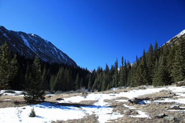
 So we walked another mile and there is the sign post that says Big Willis Gulch and the trail is another old mining road, not tough to find or to follow through the woods. We soon crossed back to the other side of the creek, now fully frozen, and made our way up Big Willis proper. No route finding issues at all and after maybe a mile or so, we broke out of the trees into an open field where the road skirted the toe of a talus slope before cutting back to light pines and heavy willows. Fortunately, another group had come out just a few days before and had tracked a nice path through one or two of the more obscure trail cuts. So we walked another mile and there is the sign post that says Big Willis Gulch and the trail is another old mining road, not tough to find or to follow through the woods. We soon crossed back to the other side of the creek, now fully frozen, and made our way up Big Willis proper. No route finding issues at all and after maybe a mile or so, we broke out of the trees into an open field where the road skirted the toe of a talus slope before cutting back to light pines and heavy willows. Fortunately, another group had come out just a few days before and had tracked a nice path through one or two of the more obscure trail cuts.
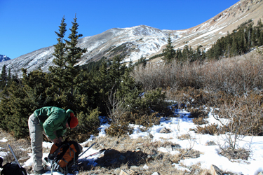
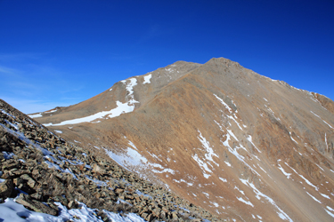 Once we put the trees behind us, we knew we were at the base of Rinker, all we had to do was climb the highest point and we'd score the summit. We started up and the wind met us with growing force as we advanced up the slope. There was no trail that we'd found (unlike the trail we would come down a little while later) so we aimed for a direct line up the ridge that led to the summit. Calvin took the lead and Bob and I dragged ass well behind him. Bob had worked out hard that week and I had cut a cord of wood the day before and then gone to a client Xmas party until 10:30. Go figure why were were feeling great. Once we put the trees behind us, we knew we were at the base of Rinker, all we had to do was climb the highest point and we'd score the summit. We started up and the wind met us with growing force as we advanced up the slope. There was no trail that we'd found (unlike the trail we would come down a little while later) so we aimed for a direct line up the ridge that led to the summit. Calvin took the lead and Bob and I dragged ass well behind him. Bob had worked out hard that week and I had cut a cord of wood the day before and then gone to a client Xmas party until 10:30. Go figure why were were feeling great.
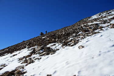
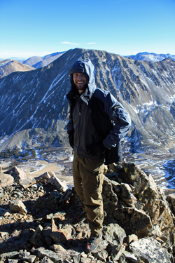
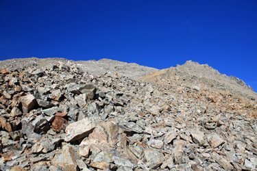 Calvin made the summit while Bob and I were still a good 200 feet of vertical below him. But my wealth of climbing experience, including over 100 14'ers told me something that Calvin had not quite tuned into yet . . . we were on the wrong part of the peak. Calvin raised his arms to rejoice on reaching the summit and I noted that there was a point in the other direction that was about 500 feet higher still. I waved Calvin in our direction and we sidehilled to the saddle that separates the 13,200 foot sub summit of Calvin's Rinker from the real thing off to the east a bit. We made the saddle and Calvin joined us for a trudge up the talus to the real summit. Calvin made the summit while Bob and I were still a good 200 feet of vertical below him. But my wealth of climbing experience, including over 100 14'ers told me something that Calvin had not quite tuned into yet . . . we were on the wrong part of the peak. Calvin raised his arms to rejoice on reaching the summit and I noted that there was a point in the other direction that was about 500 feet higher still. I waved Calvin in our direction and we sidehilled to the saddle that separates the 13,200 foot sub summit of Calvin's Rinker from the real thing off to the east a bit. We made the saddle and Calvin joined us for a trudge up the talus to the real summit.
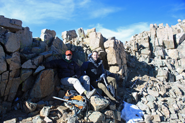
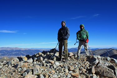 Were we really headed in he right direction? Yes, I knew we were because I came up with the bright idea to read the map. See, if you draw a line through the summit of Mt. Hope and then connect that to the summit of Rinker, it goes through that round lake in the valley. All you gotta do is look at Hope and turn about face and yes, you too can climb the right peak. We scored the high point before taking shelter from the wind that was making the summit bid an experience in wind chill. Lunch was served in a cleft that was facing the sun and gave enough relief to break the wind. Fifteen minutes later we were well chilled and packed up to head for the truck. We knew one thing and that was we would descend to the floor of the gulch from the Rinker-Twin Peaks saddle . . . that was downwind. Were we really headed in he right direction? Yes, I knew we were because I came up with the bright idea to read the map. See, if you draw a line through the summit of Mt. Hope and then connect that to the summit of Rinker, it goes through that round lake in the valley. All you gotta do is look at Hope and turn about face and yes, you too can climb the right peak. We scored the high point before taking shelter from the wind that was making the summit bid an experience in wind chill. Lunch was served in a cleft that was facing the sun and gave enough relief to break the wind. Fifteen minutes later we were well chilled and packed up to head for the truck. We knew one thing and that was we would descend to the floor of the gulch from the Rinker-Twin Peaks saddle . . . that was downwind.
 The route down to the saddle was steep and offered good trail segments before dropping us at the start of this winter's cornice. I opted to circle high and skip the snow in the boots before heading down the broad gully leading back to the floor of Willis Gulch. The terrain was more sand and scree than anything and the feet clicked off quickly but I was still on the tired side so slow was the game, at least with regard to sparing a repeat of my San Juan ankle treatment. Once at the base of the Gulch, we shot a few Gu's and hydrated before heading out the trail. It was now 3:40 and it gets dark early in December. No sweat, we had 2 headlamps among 3 people, hence the urge to hustle. The route down to the saddle was steep and offered good trail segments before dropping us at the start of this winter's cornice. I opted to circle high and skip the snow in the boots before heading down the broad gully leading back to the floor of Willis Gulch. The terrain was more sand and scree than anything and the feet clicked off quickly but I was still on the tired side so slow was the game, at least with regard to sparing a repeat of my San Juan ankle treatment. Once at the base of the Gulch, we shot a few Gu's and hydrated before heading out the trail. It was now 3:40 and it gets dark early in December. No sweat, we had 2 headlamps among 3 people, hence the urge to hustle.
 I was not worried about the trip out (simple deduction . . . I was one of the two who had a headlamp) but I was pleased to get down across a section of the trail that was totally iced over for about 100 feet in the upper part of the gulch. Once past that obstacle, we were soon on the old road and from there it was not more than a case of follow the leader to the main trail, over the bridge, along the ditch and then down to the truck for a 5:30 p.m., in the dark, arrival. I was not worried about the trip out (simple deduction . . . I was one of the two who had a headlamp) but I was pleased to get down across a section of the trail that was totally iced over for about 100 feet in the upper part of the gulch. Once past that obstacle, we were soon on the old road and from there it was not more than a case of follow the leader to the main trail, over the bridge, along the ditch and then down to the truck for a 5:30 p.m., in the dark, arrival.
Needless to say, you get one of these trips every year. You have the map but elect to not read it, you read the map but do not do so correctly, you have less than one lamp per person but know you won't come out in the dark. Such trips are avoidable, but in hind sight, they are, with luck, generally harmless and fun once a year among good friends.
|
