Mount Sherman
March 21, 2010 - via Leavick ("winter")
I'll start with a confession . . . this was not a winter climb but actually occurred on March 21st, the first full day of calendar Spring . . . however you sure couldn't tell by looking at the place. Bob and I wanted to get out on the AT skis, wanted to avoid the I-70 traffic, and just couldn't get enthusiastic about the Park for no particular reason. Our alternative was a ski of Mount Sherman, where I knew we'd have terrain tame enough not to do me in and where we could get some altitude with no more than a mile of easy road approach from the car. It was a good plan.
 We were southbound from Cheyenne at 4:10 a.m. and made it through Denver and on to Fairplay by about 7:00. The road from 285 to the trail head was rumored to be plowed to the Hilltop Mill at the Leavick town site but there had been inches to feet of snow in the Denver area just a day or so before . . . hmm. The county road was snow covered for the first couple of miles and then it was really snow covered, like anywhere from four inches to a foot in places. There had been one vehicle ahead of us and my hat is off to the driver of that BMW SUV for he cut a perfect set of tracks, tracks that I took full advantage of. We got to just a quarter mile past the Fourmile Campground and there sat the BMW with four climbers making their final preparations for a day on Sherman. I drove past them, figuring to see why they quit where they did and after going another 100 yards and using my avi shovel to pay for my vanity, I backed up and parked where they had elected to call it quits. We were southbound from Cheyenne at 4:10 a.m. and made it through Denver and on to Fairplay by about 7:00. The road from 285 to the trail head was rumored to be plowed to the Hilltop Mill at the Leavick town site but there had been inches to feet of snow in the Denver area just a day or so before . . . hmm. The county road was snow covered for the first couple of miles and then it was really snow covered, like anywhere from four inches to a foot in places. There had been one vehicle ahead of us and my hat is off to the driver of that BMW SUV for he cut a perfect set of tracks, tracks that I took full advantage of. We got to just a quarter mile past the Fourmile Campground and there sat the BMW with four climbers making their final preparations for a day on Sherman. I drove past them, figuring to see why they quit where they did and after going another 100 yards and using my avi shovel to pay for my vanity, I backed up and parked where they had elected to call it quits.
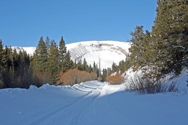 We briefly debated the skis and though I did not know exactly how much further we would have to walk as a result of the drifted road, I guessed we were still 2 miles from the Leavick terminus. Now the question was do we want to haul the skis for an extra 4 miles, or more rightly, did Bob want to haul his non AT binding skis that distance plus the extra mile to the summer trail head and real start of the climb. That need plus the avi forecast led us to opt for booting it as far as we could go and then switching to snowshoes when boot travel was no longer an option. Regardless we were blessed with a bluebird day, not a cloud in the sky and a temp not so low that there was not hope that the forecast of a 45 degree day was discounted without a second thought. We briefly debated the skis and though I did not know exactly how much further we would have to walk as a result of the drifted road, I guessed we were still 2 miles from the Leavick terminus. Now the question was do we want to haul the skis for an extra 4 miles, or more rightly, did Bob want to haul his non AT binding skis that distance plus the extra mile to the summer trail head and real start of the climb. That need plus the avi forecast led us to opt for booting it as far as we could go and then switching to snowshoes when boot travel was no longer an option. Regardless we were blessed with a bluebird day, not a cloud in the sky and a temp not so low that there was not hope that the forecast of a 45 degree day was discounted without a second thought.
 The drifted over section of road was perhaps 100 yards long but as we walked through it, there remained no doubt in my mind that I had gotten as far as I could that morning. Once past this section, the snow as rutted by prior traffic and most of the time we had a hard rut to walk in and there was no need to got to the snowshoes until we got to the Leavick terminus, two miles from the truck. At Leavick, we met the four climbers from the BMW and chatted about the fact that it The drifted over section of road was perhaps 100 yards long but as we walked through it, there remained no doubt in my mind that I had gotten as far as I could that morning. Once past this section, the snow as rutted by prior traffic and most of the time we had a hard rut to walk in and there was no need to got to the snowshoes until we got to the Leavick terminus, two miles from the truck. At Leavick, we met the four climbers from the BMW and chatted about the fact that it 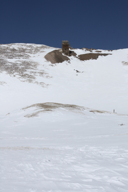 was time for us to take the lead. So we did, for all of 25 yards where we concluded that the snowshoes were required. The other folks passed us as we stopped and put on the shoes to once again follow in their track. Snowshoes on, we got moving again and within 300 yards, we were out in front, breaking trail, doing our part as the others had beaten a good track wherever the road did not have sufficient ruts to preclude a trek through six or eight inches of snow. was time for us to take the lead. So we did, for all of 25 yards where we concluded that the snowshoes were required. The other folks passed us as we stopped and put on the shoes to once again follow in their track. Snowshoes on, we got moving again and within 300 yards, we were out in front, breaking trail, doing our part as the others had beaten a good track wherever the road did not have sufficient ruts to preclude a trek through six or eight inches of snow.
The distance from the Hilltop Mill (Leavick) to the summer trail head is a bit over a mile and after the trees stop, there is little protection from the wind. I told Bob that Sherman would likely be a windy affair but the wind was warm, i.e. no ice in the beard. We trekked on through the open stretch and I thought that we would likely go to the summer trail head and 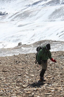 then make a 180 for the truck, now three miles distant. The wind was not blowing that hard, but I'd been up Sherman before and I knew that if we went for the summit, the extra distance on the approach would add a full six miles to the climb. Winter climbs on snowshoes are hard and I did not figure either of us really needed the extra mileage. then make a 180 for the truck, now three miles distant. The wind was not blowing that hard, but I'd been up Sherman before and I knew that if we went for the summit, the extra distance on the approach would add a full six miles to the climb. Winter climbs on snowshoes are hard and I did not figure either of us really needed the extra mileage.
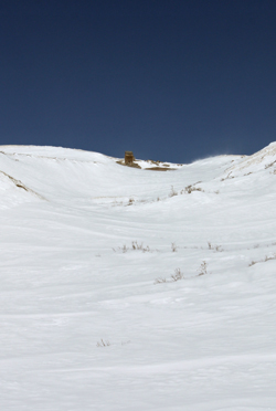
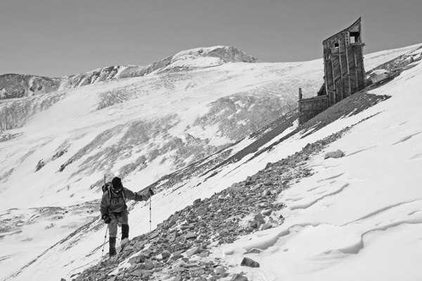
We arrived at the summer trail head and instead of sticking with the mine road that leads to the Boston Mine ruins, I just cut straight up the gulch, aiming for the ruins of the Hilltop Mine oh so far away. The gulch was shallow enough that I was not worried about avi slopes or terrain traps but I knew that would not be the case as we approached the slope below the Hilltop and then again the slope leading to the Sherman - Sheridan saddle. Anyway, those slopes were not that important as the wind was blowing right well and I'd scored enough physical trailing to justify the day should a turn around be in order. We moved up the center of the gully and onto the hill that abuts the slope upon which the Hilltop mine works sit.
 Whoompf! I thought I'd heard one before but then I wasn't sure. This time I stopped dead in my tracks. Bob looked at me with the "what the hell look" and I explained that a layer of the snowpack had just collapsed, as a result of our passage, and that we were now at a point where avalanche was an operative condition. The route up to the mine had two significant swales and a shallow divide in the center where there was a swath of rock exposed. I advised Bob that I'd make the climb while he observed and then he could follow me. But for the rock swath, our climb would have terminated then and there. We crested the slope without any further avi signs and took shelter in the lee of a mine building to shoot a Gu and drink some water before taking on the slope leading to the saddle. Whoompf! I thought I'd heard one before but then I wasn't sure. This time I stopped dead in my tracks. Bob looked at me with the "what the hell look" and I explained that a layer of the snowpack had just collapsed, as a result of our passage, and that we were now at a point where avalanche was an operative condition. The route up to the mine had two significant swales and a shallow divide in the center where there was a swath of rock exposed. I advised Bob that I'd make the climb while he observed and then he could follow me. But for the rock swath, our climb would have terminated then and there. We crested the slope without any further avi signs and took shelter in the lee of a mine building to shoot a Gu and drink some water before taking on the slope leading to the saddle.
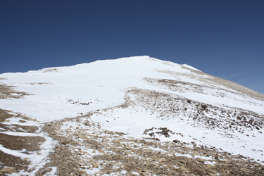
 The saddle had a substantial cornice and the main slope of Sherman seemed well loaded, hence neither offered a route to the ridge that would lead us to the summit. However, there was another narrow band of rock, actually, a couple of rock showings that I felt could be connected safely. I again led and set a cautious track to the upper flank of the saddle, much of which was bare. We connected bare spots until we reached a shallow snowfield that was the end of the saddle and the start of the ridge proper. No instability at this point and we were soon enough on the ridge proper. I reminded Bob that the ridge was deceptive and that we had more than one false summit to cross before we arrived at the flattish shoulder that is the true summit. The saddle had a substantial cornice and the main slope of Sherman seemed well loaded, hence neither offered a route to the ridge that would lead us to the summit. However, there was another narrow band of rock, actually, a couple of rock showings that I felt could be connected safely. I again led and set a cautious track to the upper flank of the saddle, much of which was bare. We connected bare spots until we reached a shallow snowfield that was the end of the saddle and the start of the ridge proper. No instability at this point and we were soon enough on the ridge proper. I reminded Bob that the ridge was deceptive and that we had more than one false summit to cross before we arrived at the flattish shoulder that is the true summit.
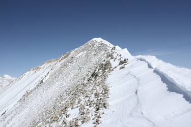
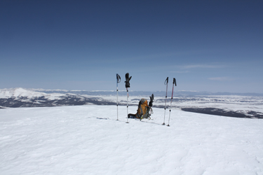
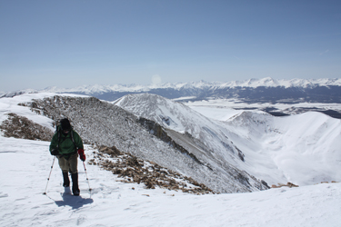 The ridge was well corniced and offered as close a semblance to a knife edge snow line as one will get on the more mellow 14'ers. We stayed to the west edge and climbed steadily up and over the false summits, one then another until we caught sight of the summit mass. The final 100 yards was a tramp from the sharper ridge to the high point, marked by a post with a summit register attached. We dropped the packs at the top, stabbed the poles in and feasted on the beauty of the surrounding ranges and the fact that Pachamama had granted us a respite from the wind upon our arrival. We left the truck at about 8:00 in the morning and reached the summit at 2:15, late by all of my standards but with not a cloud in the sky and the recent delivery of an extra hour of daylight, there was no time crunch or cause for concern. The ridge was well corniced and offered as close a semblance to a knife edge snow line as one will get on the more mellow 14'ers. We stayed to the west edge and climbed steadily up and over the false summits, one then another until we caught sight of the summit mass. The final 100 yards was a tramp from the sharper ridge to the high point, marked by a post with a summit register attached. We dropped the packs at the top, stabbed the poles in and feasted on the beauty of the surrounding ranges and the fact that Pachamama had granted us a respite from the wind upon our arrival. We left the truck at about 8:00 in the morning and reached the summit at 2:15, late by all of my standards but with not a cloud in the sky and the recent delivery of an extra hour of daylight, there was no time crunch or cause for concern.
 We reversed our course down the ridge as we'd elected to leave the snow shoes that we'd used from Leavick to the Hilltop, beside one of the mine buildings, hence we could not make a loop off of the White Ridge. Had the conditions been better, we'd have skied the slope but the pockets of considerable avi terrain were all the warning we needed to retrace our proven course. We arrived back at the Hilltop in short order, stopping on the saddle to greet a lone snow boarder who had made a traverse from Peerless to Sheridan and now was about to summit Sherman before returning to where our cars were parked. We tracked past the Hilltop and on down the slope, one at a time, after which there were no other avi considerations. We We reversed our course down the ridge as we'd elected to leave the snow shoes that we'd used from Leavick to the Hilltop, beside one of the mine buildings, hence we could not make a loop off of the White Ridge. Had the conditions been better, we'd have skied the slope but the pockets of considerable avi terrain were all the warning we needed to retrace our proven course. We arrived back at the Hilltop in short order, stopping on the saddle to greet a lone snow boarder who had made a traverse from Peerless to Sheridan and now was about to summit Sherman before returning to where our cars were parked. We tracked past the Hilltop and on down the slope, one at a time, after which there were no other avi considerations. We 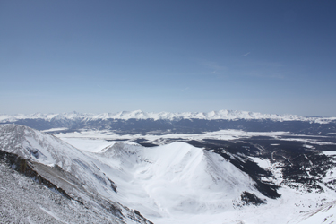 arrived at the summer trail head a half hour later and started the long hike back down to the truck, three miles distant. arrived at the summer trail head a half hour later and started the long hike back down to the truck, three miles distant.
The road march was a bit easier as the fellow with the board most kindly chose the boot track as his course and provided us with a nicely compacted track until we reached Leavick, after which the old ruts made for a fast walk out. We arrived at the truck at about 5:15, making for a winter climb of 9 hours and change, not bad given the extra 6 miles that one snow drift added to an otherwise short winter ascent.
|
