|
||||||||||||||||||||||||||||
|---|---|---|---|---|---|---|---|---|---|---|---|---|---|---|---|---|---|---|---|---|---|---|---|---|---|---|---|---|
Longs PeakJune 5-6, 2004 - Flying Dutchman/Clarks Arrow/North Face
Physical conditioning was the name of the game when we left Cheyenne for a climb of the Notch Couloir on Longs Peak. Our upcoming trip to Peru was but three weeks away and it was time to determine whether the conditioning program was getting the job done or if we should really start sweating getting in shape. What better way to tell than a little circuit hike on Longs Peak?
Our game plan was to climb to the base of Mills Glacier and bivy for the night in the lee of some rock before getting up well before the dawn and climbing the Notch Couloir. Neither of us had been on this route before, not to mention across the Broadway ledges on snow, so the trip would add a touch of exposure to the conditioning effect. We figured to climb the notch on frozen morning snow before the east facing slope took too much sun and then either take a shot at the chimney leading up ridge to the summit or if the muscles were flagging, just drop off the back onto the conclusion of Clarks Arrow and hoof it up to the summit from there.
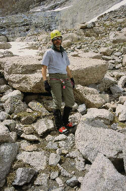
We arrived at the parking lot at about 12:30 in the afternoon, dreading the thought of finding a place to park but being surprised with an open spot right across from the trailhead proper. We were pretty much pre-packed but we still engaged in a now all to familiar weighing of the packs using G’s jumbo fish scale. We scored equally poor grades, 44 pounds. Rock rack, two ropes, minimal bivy gear, all stuffed into two 44-litre packs. What goes? We thought about dropping the extra rope but then the recurring thought of the upcoming trip and the need to condition precluded that move. We left the parking area a bit heavy but figured that at least we would not have to lug all that weight past the bivy. We never seem to get the figuring right . . .
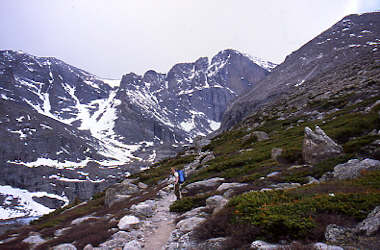
Lets face it . . . I hate carrying a 40+ pound pack and I hate the approach trail to Longs Peak, but you gotta do what you gotta do. One must keep in mind the end goal, the Notch, a plumb climb, good photos, a confidence boost . . . with that goal and some classic gutter conversation, two guys can lug a lot of weight up a trail. We paused at the higher stream crossing, just shy of tree line; to pump water as we have also taken to carrying just enough water to make it between pump stops. We pumped and moved on into the sunlight above tree line and my gosh . . . the warmth and still air. Longs Peak and still air, warm still air? We started to wonder about whether the snow would freeze the next day and what would the Notch’s snow would be like.
We arrived at the cut off to Chasm Lake and as we both looked at our pending route; we saw a mass of snow move down the couloir and into the air. Enough snow moved to make a continuous fall to the ground below and five seconds later the sound of a passing jet overhead. The Notch discharged a layer of warn afternoon snow and left no doubt in our minds that any fool up there on anything but hard frozen snow was risking a short ride to this mountain’s roll of deceased climbers. The time had obviously come for a serious re-assessment of our planned route.
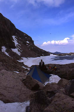
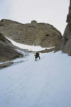
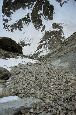
A snowfield eased the trip up the Chasm Lake headwall; however the energy savings achieved was redeposited in the course of a right side traverse of the edge of Chasm Lake. We looked at the left side snow route but after dipping a foot in the lake below Mount Richthofen, I opted for the rock route as a safer option. We soon made our way to the bivy cave we used last September only to find it packed full of snow. No problem . . .dig it out, but for the fact that we saved weight by leaving the avi. shovel back in the truck . . . saved weight, oh yea . . . Oh well, find another overhang, yea right, one without snow? There were none but about 100 feet away there was a hole between some boulders that was full of snow and just waiting to be trampled flat for a bivy site.
We soon had a flat spot and I must confess up went the Megamid to provide a break from the gusts of wind that seemed to come once in while just to remind us that we were indeed in the company of Longs Peak. Next came dinner and then the not so welcome prospect of getting into the sleeping bags to await the alarm at 3 a.m. We discussed the earlier snow slide and whether or not the temperature would drop enough to put a good freeze on the Notch Couloir. We agreed that if the snow was hard frozen at our bivy we would get moving right away in an effort to score the primo route. Otherwise, we would again head up the Flying Dutchman to re-tangle with the ice-covered crux.
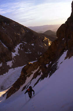
The temperature at 3 a.m. was a balmy 38 degrees and the snow was crusted but not good enough to lead us toward Lamb’s Slide, so the alarm was reset to 4 a.m. and a new plan hatched. We would make the climb up the Flying Dutchman, do the icy crux, wander over to the Loft, meander around the back side of Longs via the Clark’s Arrow route (not that we had done that route before), top out, then take the North Face as a descent route and drop back to the camp via the Camel Couloir on the flank of Mount Lady Washington. A walk in the park but at least we would be carrying lighter packs . . .
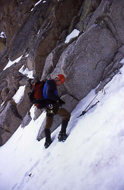
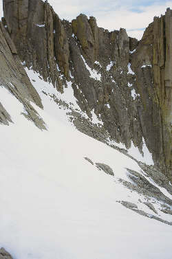
When you take a pack full of gear and remove the water filter, the down sleeping bag and the ultra light shelter it still weighs too much . . . at least on my back it does. We broke down the shelter and pumped two quarts of water for what might be a long day and then stashed the bivy pads and non-climbing gear under a rock overhang. The ascent up the Flying Dutchman calls for about a 1600-foot climb up snow angled at about 50 to 55 degrees. The couloir starts off wide but soon narrows as it winds upward toward the icy crux located but 100 feet from its connection with the upper reach of Lamb’s Slide. We made good time to the crux, giving thanks to the guided group that just the day before had kicked steps all the way up the couloir. Many of the steps were deep but as we went higher they were bare toe holes in a more solidly frozen slope. The crux on the Dutchman is a rock or ice pitch about 25 feet in height. Your actual route will depend on what shape the pitch is in and for us that meant a choice between a crappy mix of rock and ice or a pure ice pitch. G and I had traded banter most of the way up the couloir and finally decided that I would lead the pitch since the last time we did this climb, the pitch was in ratty shape with but a thin layer of ice. The crew we passed the day before on the approach had done this climb and indicated that they had buried 17 cm ice screws to the hilt and the ice was in good shape. We had the same impression as we prepared our gear to make the climb. Gary set a belay anchor in some rock in the east side of the slope and I readied ice screws and slings for the climb.
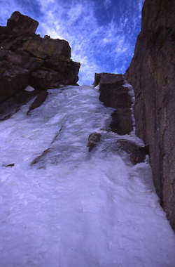
I admit that I’m not much of an ice climber having done one crappy lead right here in the past and a day of top roped climbing as part of an alpine course. This slope looked deceptively shallow and I figured it would be a cakewalk, bearing in mind my prior experience. I started up using two BD Shrike ice tools and after placing a snow picket right at the base, I set my first screw after three abortive attempts that bottomed in rock after, you guessed it . . . just about 17 cm. That is fine but I had four 22 cm screws on my harness for the job. Attempt number four was a success with a really solid placement. The pitch appears low angled in photos but by the time I went for screw number two, I was unable to see my feet because of the ice bulge that transformed the climb into vertical ice. Screw number two went in after I calmed my sewing machine leg and then I was off four number three. I knew that the third would be at the top of the steep section and provide protection for the lesser-angled portion of the pitch.
Screw number four was simply not to be as I could see the water running below the ice and even though I got full penetration, nothing more came from the center of the tube other than toothpaste. Plan two was for rock gear and a cam fit nicely into the crack located just inches from where the screw was not meant to be. Above this point; however we had agreed that I would try sooner than later for a belay point for no other reason than to keep the both of us in some sort of motion. But if you ever do this climb, you might come to the same conclusion I did both times I’ve led . . . there simply is no good place except for the completely obvious rock that lies at nearly a full rope length above the start of the climb. I went there again and with a few remaining slings and a twenty-foot cordelette, I had a station in place from which to protect G’s ascent.
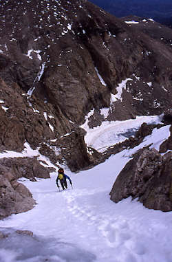
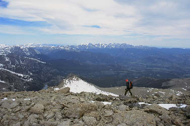
Gary followed easily with just momentary delays, as he pulled pro on the way up. Soon enough he was at the belay and we dumped all the gear helter skelter into our packs to get a move on toward the Loft. The both of use had had some sit time so rather than clean up in the Dutchman Couloir, we opted for the flats of the Loft for food, drink, and housekeeping. We also needed to assess our condition, the weather, and if we were headed down the Loft or onward toward the summit of Longs. Once at the Loft, we encountered strong winds and found a spot in the lee of a large rock to make our decision. We were both pretty tired but we were not ready to call it a day, therefore we opted to head for Longs via Clark’s Arrow. Neither of us had been on the route before and we really only knew that rumor had it you needed to drop down from the Loft’s elevation before making your way north. We headed in that direction and soon enough found ourselves faced with a drop off and no obvious route. Drop down. We did and spotted a pair of cairns and portions of well-worn trail that just had to be the route. Parts had a bit of snow but most was clear as we dropped and traversed, hoping that the effort was not for naught. The route was solid class 3 and in some places class 4 where a climb down was needed to stay along the sloping slabs that form the rear face of Longs. We made it to the low point and then began the climb back up mixed terrain to the base of the Notch. Beyond that point, the route was snow in the form of a 50-degree crescent shaped snowfield hanging above a cliff line. We gave some thought to the warm temps but the snow had been shaded and was still in reasonable shape. We made the traverse of the angled field and cut upward over more snow to intersect the Keyhole route at the base of the Homestretch.
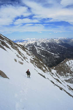
The winds so common to Longs were now in full force as we were buffeted by gusts reaching 60 to 70 mph, i.e. enough for me to stop and hold on to a rock until they passed. The Homestretch was mixed rock; snow and a good bit of ice but still reasonably traversed still using crampons and a single axe. Not soon enough, and after about 4 rest stops, we crossed a final patch of snow and stepped onto the summit plateau, alone. G and I took all of a one-minute break and headed for our descent route down the North Face. We cut across to a good spot and headed first down through snow and rock and then across rapidly warming snow to a point just above the uppermost eyebolt. We dropped our packs and dug out what we would need to make the rappel.
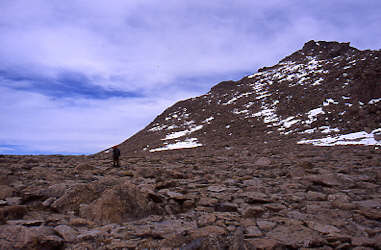
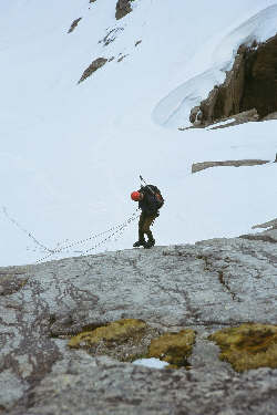
The good news was that we were going to do the whole drop in one long rappel having brought two ropes. The bad news was that during one of my stops to dig about in my pack for my second water bottle, I managed to deposit my climbing harness for some marmot to cherish amongst his assorted treasures. Regardless of where it is, it was not with me at the top of the rappel. As I issued a short string of expletives, G set up the rappel and I took a knife to my 20-foot cordelette. Army ROTC did make one lasting impression on me . . . the proper way to tie a Swiss seat for a rappel. By the time G was ready to make his way down, I had a harness in place and without too much more delay, we were headed down the North Face rock pitch to the snow below. We pulled one rope and soon enough the other came our way at the expected high rate of speed. The two were bundled and secured to our packs and we were off toward Mount Lady Washington and the Camel Couloir we knew would provide a route back to the gear stash above Chasm Lake. Neither of us had used this descent route before so we took a hard look at this from both the bottom the afternoon before and the summit to burn into our joint memories what we figured would be the correct route. Of course I had it in my mind that there would be a climber’s trail but after my last “going to be a trail” escapade this winter, I know better than to believe myself. The start is among huge boulders but after you get perhaps 1/3 of the way down, yes indeed there are trail segments and the pieces pretty clearly unfold with the descent. We reached the cut back point, which marks the final 1/3 of the descent and hoped that the snow was still in fair shape. It wasn’t. We alternated between sinking to our knees and our butts but finally found some harder crust for the bottom half of the descent. Then it was a just a short hike to the gear stash near the previous night’s bivy and an opportunity to pump, hydrate and eat before heading for the parking lot. We drank a quart each, ate some jerky and goo and packed for the five-mile haul to the trailhead. Again, too much weight but at least we chose to avoid the rocks on the north shore of the lake in favor of a snowy and flat transit on the slopes above the southern bank. Then on down the interminable Longs Peak trail to the waiting burgers of Estes Park.
|
