Mount Arkansas
April 22, 2012 - North Couloir Snow Climb
John BB and I had attempted Mts. Arkansas and Tweto two years before and been turned around by whiteout conditions. This time Bob and I were taking a shot at Mt. Arkansas only but we planned to summit via the North Couloir, a steep snow route that leads to within feet of the summit. The winter snows were fading fast, very fast, but a recent storm had added anywhere from 6 to 12 inches to the area around Climax, so we were off to climb this route while it was . . . hopefully . . . in condition.
 We knew we had to be on the trail early as this route would take a fairly early sun hit and I expected the snow conditions might go to hell pretty early in the day. Rather than make the all too early start from Cheyenne proper, we opted to leave at about 6 p.m. the night before and camp at the Mayflower Gulch trailhead, a parking lot that I have camped in many times in the past, both for that trailhead and others in the vicinity. We had the tent up by 10 p.m. and set the alarm for 4:30 the next morning. We knew we had to be on the trail early as this route would take a fairly early sun hit and I expected the snow conditions might go to hell pretty early in the day. Rather than make the all too early start from Cheyenne proper, we opted to leave at about 6 p.m. the night before and camp at the Mayflower Gulch trailhead, a parking lot that I have camped in many times in the past, both for that trailhead and others in the vicinity. We had the tent up by 10 p.m. and set the alarm for 4:30 the next morning.
The alarm came early enough and after some griping we were out of the tent by 4:45 and on the road by 5. We passed the Climax mine and descended the hairpin turn to pull off at the stub for the road that leads up the gulch that 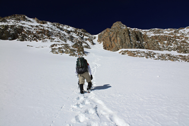 forms the start of the Arkansas River. We packed the gear up for a Spring climb instead of the usual Winter weight, and were on our way by 5:30. The road leading up the gulch avoids the posted mine property and for us was a hassle free route into the upper portion of the gulch. I had made sure to leave the truck on what I felt was CDOT right of way and as we made our way up road, we stayed well clear of the obviously posted mine property. forms the start of the Arkansas River. We packed the gear up for a Spring climb instead of the usual Winter weight, and were on our way by 5:30. The road leading up the gulch avoids the posted mine property and for us was a hassle free route into the upper portion of the gulch. I had made sure to leave the truck on what I felt was CDOT right of way and as we made our way up road, we stayed well clear of the obviously posted mine property.
The Fremont Pass Snowtel site advised of a 43 inch deep snowpack but that must be for the hill opposite the mine gate. Our route was a mix of clear road and patchy snow for the first quarter mile before the we on snow with just a few bare patches here and there. The snow was hard 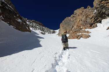 frozen and for the first mile, the postholes were thankfully few and far between. After about a mile, we came to a point where a road continues along the lower flank of the valley and another cuts upward, looking to access the lower shoulder of a spine dropping from the long ridge that forms an alternative route to the summit of Mt. Arkansas. We were not in the market for a long ridge route as our game plan called for a direct approach up the north Couloir, a steep snow route, hence a short hop over the lowest reach of the shoulder with no thought of an ascent. frozen and for the first mile, the postholes were thankfully few and far between. After about a mile, we came to a point where a road continues along the lower flank of the valley and another cuts upward, looking to access the lower shoulder of a spine dropping from the long ridge that forms an alternative route to the summit of Mt. Arkansas. We were not in the market for a long ridge route as our game plan called for a direct approach up the north Couloir, a steep snow route, hence a short hop over the lowest reach of the shoulder with no thought of an ascent.
I recalled much of the route so far from my trip two years before with John BB. John and I had struggled though deep powder, taking turns breaking trail on snowshoes. This time we made it a full mile before I opted to cut off and 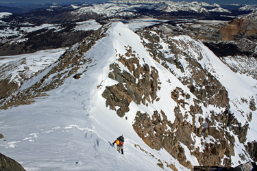 follow a set of ski and boot tracks that were cutting higher, seemingly to attain the higher basin that grants access to the north face of Mt. Arkansas. The snow was still cold but we'd hit a rotten section, so we put on the snowshoes, traversed the collapsing section and then kept the shoes on for some harder snow where the shoes' crampons were handy. We crossed over the spine into the lower basin, arriving up slope from the lake and in position to traverse on snow to the base of the climb proper. follow a set of ski and boot tracks that were cutting higher, seemingly to attain the higher basin that grants access to the north face of Mt. Arkansas. The snow was still cold but we'd hit a rotten section, so we put on the snowshoes, traversed the collapsing section and then kept the shoes on for some harder snow where the shoes' crampons were handy. We crossed over the spine into the lower basin, arriving up slope from the lake and in position to traverse on snow to the base of the climb proper.
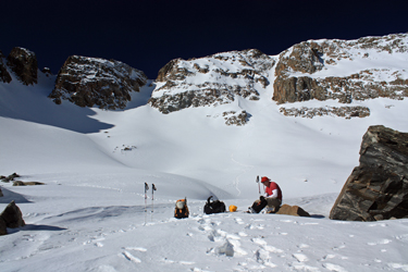
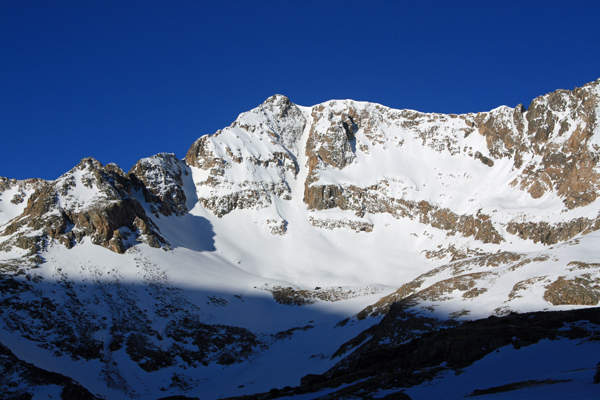
 We went about halfway to the base of the couloir before taking off the snow shoes as the surface was supportive but angled enough that the snow shoes were more trouble than they were worth. The traverse led up and around to the base but in order to get to the base proper, one does have to gain another couple of hundred feet before arriving as a last rock outcrop and the perfect place to put on the crampons and stash the hiking poles. Once the crampons were on, we each took our regular mountain axe and headed upward, swapping off the lead in the lower run out portion before ascending into the throat of the couloir proper. Someone else had taken a shot at the climb but appears to have turned at about the 2/3 mark . . . perhaps the day before. We went about halfway to the base of the couloir before taking off the snow shoes as the surface was supportive but angled enough that the snow shoes were more trouble than they were worth. The traverse led up and around to the base but in order to get to the base proper, one does have to gain another couple of hundred feet before arriving as a last rock outcrop and the perfect place to put on the crampons and stash the hiking poles. Once the crampons were on, we each took our regular mountain axe and headed upward, swapping off the lead in the lower run out portion before ascending into the throat of the couloir proper. Someone else had taken a shot at the climb but appears to have turned at about the 2/3 mark . . . perhaps the day before.
 We followed the prior path, which was filled in with a bit of snow but by the half way mark, we were also having second thoughts as the snow was starting to warm. Not enough to drip water from a fist full but enough that we were not kicking steps but stomping steps to get a base to step up from. I turned to gain the rock on the left side at about the 2/3 mark and found no purchase as all of the rock seemed to be couloir sloping slabs. I took another shot at an exit a bit further up and was again turned back. I told Bob that the snow was crap and we needed to really hustle up or turn the climb. We swapped the lead another time or two, both now focused on making time to the crest, knowing we had less than 10 or 15 minutes before we would turn the climb due to the warming snow. We followed the prior path, which was filled in with a bit of snow but by the half way mark, we were also having second thoughts as the snow was starting to warm. Not enough to drip water from a fist full but enough that we were not kicking steps but stomping steps to get a base to step up from. I turned to gain the rock on the left side at about the 2/3 mark and found no purchase as all of the rock seemed to be couloir sloping slabs. I took another shot at an exit a bit further up and was again turned back. I told Bob that the snow was crap and we needed to really hustle up or turn the climb. We swapped the lead another time or two, both now focused on making time to the crest, knowing we had less than 10 or 15 minutes before we would turn the climb due to the warming snow.
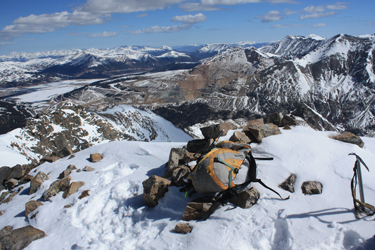
I broke the top of the couloir, exiting on the climber's right to avoid the cornice that blocked about 2/3 of the top of the gully. The snow at the top hardened up nicely, took a fine step and put the alpine back into the climb. I exited and then Bob followed before we took off for the summit. I knew the summit was close to the top of the couloir bit I did not realize it 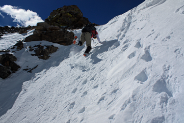 was but a two minute rock hop from the end of the snow. We were on the summit in no time, took a few photos and then headed back to the snow to descend before the day got any hotter. was but a two minute rock hop from the end of the snow. We were on the summit in no time, took a few photos and then headed back to the snow to descend before the day got any hotter.
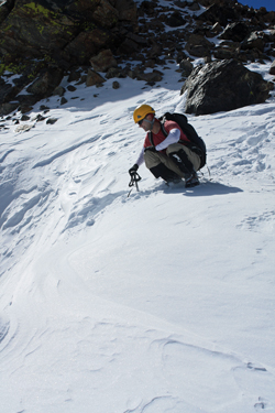
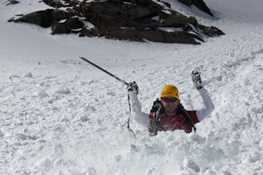
I downclimbed the first 100 feet of the slope before taking the glissade position, figuring to put the route behind me in about 2 minutes flat. The glissade was perfect and within just a minute or two I was at the base. Bob followed and along the way we both practiced our axe arrests, although the dropping of a knee into the snow was more effective.
 Soon enough were were back to the flat rocks and ready for an early lunch. We knew that the snow from here on might get soft but we would be clear of any avi slopes and have to deal only with postholes if were were not sufficiently motivated to put the snow shoes back on. An hour and half later were were back at the truck, having required just a bit over five hours to approach, summit and retreat to the trail head. Soon enough were were back to the flat rocks and ready for an early lunch. We knew that the snow from here on might get soft but we would be clear of any avi slopes and have to deal only with postholes if were were not sufficiently motivated to put the snow shoes back on. An hour and half later were were back at the truck, having required just a bit over five hours to approach, summit and retreat to the trail head.
|
