Mount Oklahoma
Ascent by East Slopes & descent by Southeast Slopes
July 18, 2009 - An "old school" camp
G had his ACL repaired on January 5, 2009 and on July 18th he returned to the mountains. In the tradition of pushing our luck, we selected the Grizzly Couloir on Grizzly Peak as the point of return. When I had my gallbladder removed, we waited 19 days and then took on the Dragontail Couloir of Flattop Mountain. G had a bit more recovery time so we picked a route worthy of the event. Well, maybe there is less to the story, maybe the couloir on Grizzly looked like a good route so we picked it before the close of the snow season. Well, maybe there is a bit of truth in both versions . . .
 We left Cheyenne at 11 a.m. on Saturday morning, headed to Leadville and then on over Independence Pass, headed toward the Grizzly Reservoir and a night of good camping and good food. The only problem is that I really did not conceptualize that Grizzly Peak might as well be in in Aspen, hence the odds of getting a camp spot on Saturday afternoon are zero and, short of a long drive back in the next morning, we were substantively. Trust me, that did not translate into a night under roof but into a quick re-evaluation of the available climbs where I knew I would not get skunked out of a place for the night. We left Cheyenne at 11 a.m. on Saturday morning, headed to Leadville and then on over Independence Pass, headed toward the Grizzly Reservoir and a night of good camping and good food. The only problem is that I really did not conceptualize that Grizzly Peak might as well be in in Aspen, hence the odds of getting a camp spot on Saturday afternoon are zero and, short of a long drive back in the next morning, we were substantively. Trust me, that did not translate into a night under roof but into a quick re-evaluation of the available climbs where I knew I would not get skunked out of a place for the night.
 The 'get a spot" concept eliminates anything between Buena Vista and Salida, wipes out Tigawon, and pretty much leaves you with the open field camp at the far end of the lake on the road to Winfield or something in the dispersed camping area on the Halfmoon Road that lies between Mts. Massive and Elbert. We gave thought to climbs and just did not want to deal with the switchbacks going up into the basin below Missouri and Belford (target: Emerald & Iowa) so it was off to the Halfmoon area and a choice between Oklahoma, French, Casco or something that did not have a 14 as the first number in its elevation. 14'ers without a good helping of snow attract too much Cotton for my tastes, hence the climb would be a Centennial or Bicentennial . . . minimal trail and with luck . . . little if any Cotton. The 'get a spot" concept eliminates anything between Buena Vista and Salida, wipes out Tigawon, and pretty much leaves you with the open field camp at the far end of the lake on the road to Winfield or something in the dispersed camping area on the Halfmoon Road that lies between Mts. Massive and Elbert. We gave thought to climbs and just did not want to deal with the switchbacks going up into the basin below Missouri and Belford (target: Emerald & Iowa) so it was off to the Halfmoon area and a choice between Oklahoma, French, Casco or something that did not have a 14 as the first number in its elevation. 14'ers without a good helping of snow attract too much Cotton for my tastes, hence the climb would be a Centennial or Bicentennial . . . minimal trail and with luck . . . little if any Cotton.
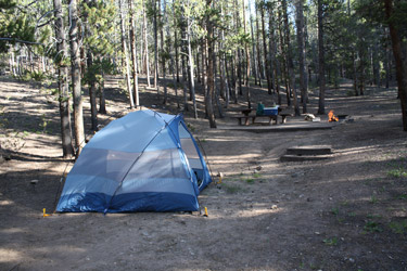
We settled on Mount Oklahoma under the presumption that we would find a camp spot, it would be in the trees, and we would be fairly close to the trail head the next morning. We returned over Independence Pass to Leadville and then out the Halfmoon Creek Road to Halfmoon West Campground. Yes, there was an open spot, a nice flat spot and no neighbors 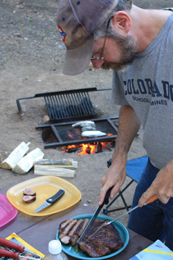 who felt the need to bring their cellular, car alarmed, technologic, amplified bass worlds with them to the woods to keep their otherwise vacant craniums filled with something as well as to entertain all those who might be seeking some peace and quiet. It was summer, we were in Colorado, and we found a quiet spot . . . simply a miracle. who felt the need to bring their cellular, car alarmed, technologic, amplified bass worlds with them to the woods to keep their otherwise vacant craniums filled with something as well as to entertain all those who might be seeking some peace and quiet. It was summer, we were in Colorado, and we found a quiet spot . . . simply a miracle.
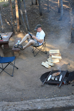
We pitched the tent, sans fly, in an effort to bring on a rain squall but instead we were later greeted by a sky full of stars. However, before the stars came out, I was on a mission as I billed this trip as an"old school car camping climb." Back in the day, when we had 14'er lists and we were a peak bagging crew, there was nothing greater than packing the camping gear, a supply of firewood, a cooler of good campfire food and the illustrious "tetanus grill" for a weekend of climbing and hanging out around the camp fire. This was to be an old school trip and I made sure that the firewood was plentiful and dry, that we had slab of beef, potatoes and corn on the cob. Add to that a bottle of Bailey's for after dinner sipping and you have an old school climbing trip of the highest grade.
July 19, 2009 - the climb . . .
 We set the alarm for 5:30 to accommodate an alpine start of dubious merit and jointly decided to add another half hour when the buzzer went off. Breakfast was minimal and within minutes the tent was down and stuffed and the camp checked for any gear not destined to be abandoned to the campground host who would surely pass through before the passing of the noon hour. We went up the road toward the Halfmoon trail head and when we got to the junction one half mile before what I remembered as the end of the road, nothing was familiar from my past trips up Mt. Massive from the back side. We went right and after just a bit came to a substantial 4WD obstacle that I did not remember from previous trips. I re-read the description and I was just plain puzzled. We backtracked to the Mt. Massive trail head and set the trip odometer but sure enough this right hand fork was the right route, unfamiliar as it was. We set the alarm for 5:30 to accommodate an alpine start of dubious merit and jointly decided to add another half hour when the buzzer went off. Breakfast was minimal and within minutes the tent was down and stuffed and the camp checked for any gear not destined to be abandoned to the campground host who would surely pass through before the passing of the noon hour. We went up the road toward the Halfmoon trail head and when we got to the junction one half mile before what I remembered as the end of the road, nothing was familiar from my past trips up Mt. Massive from the back side. We went right and after just a bit came to a substantial 4WD obstacle that I did not remember from previous trips. I re-read the description and I was just plain puzzled. We backtracked to the Mt. Massive trail head and set the trip odometer but sure enough this right hand fork was the right route, unfamiliar as it was.
We went right and within 1/4 mile were faced with a good 4WD obstacle that I did not take quite right and was left with rear tires spinning, unable to surmount the crest of the difficulty. I backed up and after another try was able to get past 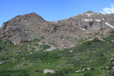 this point, only to come onto another Colony Lake grade hole/rock combination that some prior party had, to a minimal extent, tried to fill in enough to take some of the bite out of it. I gave the Toyota the gas and with some deft maneuvering, we were past this barrier as well and back onto smooth dirt track to the trail head proper. I just did not remember these two obstacles but I was feeling pretty confident of my 4WD prowess until I got to the trail head and there was a Subaru sedan, not an Outback or Forester but a low clearance sedan with flattish low rider style tires. What the @#&%, I was put firmly in my place, for there before us was the chariot of someone who was either the biggest fool in Lake County that day or a true God of the 4WD track. this point, only to come onto another Colony Lake grade hole/rock combination that some prior party had, to a minimal extent, tried to fill in enough to take some of the bite out of it. I gave the Toyota the gas and with some deft maneuvering, we were past this barrier as well and back onto smooth dirt track to the trail head proper. I just did not remember these two obstacles but I was feeling pretty confident of my 4WD prowess until I got to the trail head and there was a Subaru sedan, not an Outback or Forester but a low clearance sedan with flattish low rider style tires. What the @#&%, I was put firmly in my place, for there before us was the chariot of someone who was either the biggest fool in Lake County that day or a true God of the 4WD track.
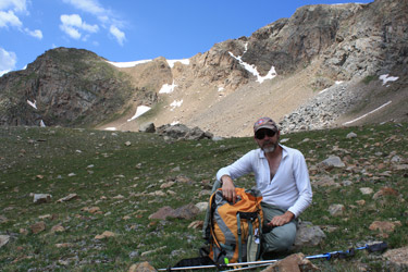
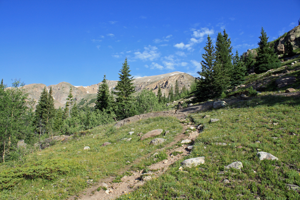
 We got to the trail head for a less than stellar alpine start, we were leaving the trail head at 7 a.m. but I'd been up the trail before and I knew we would make good time along the back side of Massive on the route to the Halfmoon Lakes. I'd soloed the route when I did Massive for the first time, taken Ed up the same route to traverse massive from Massive Green to the Massive/South Massive saddle, so I felt confident of the trail. We packed light and for the first time this year I was wearing my desert hiker/approach shoes for the day's climbing. My pack was without crampons and we split the overnight gear, figuring that the injured party would be set while #2 made for assistance. We were off and on our way on the trail, which is clear as day and giving no opportunities to get turned around. After a mile of so, we hit the junction where the trail to Mount Massive cuts 90 dgrees to the right, leading one up a series of headwalls to what I remember, from descents only, as a scree hell opportunity. We got to the trail head for a less than stellar alpine start, we were leaving the trail head at 7 a.m. but I'd been up the trail before and I knew we would make good time along the back side of Massive on the route to the Halfmoon Lakes. I'd soloed the route when I did Massive for the first time, taken Ed up the same route to traverse massive from Massive Green to the Massive/South Massive saddle, so I felt confident of the trail. We packed light and for the first time this year I was wearing my desert hiker/approach shoes for the day's climbing. My pack was without crampons and we split the overnight gear, figuring that the injured party would be set while #2 made for assistance. We were off and on our way on the trail, which is clear as day and giving no opportunities to get turned around. After a mile of so, we hit the junction where the trail to Mount Massive cuts 90 dgrees to the right, leading one up a series of headwalls to what I remember, from descents only, as a scree hell opportunity.
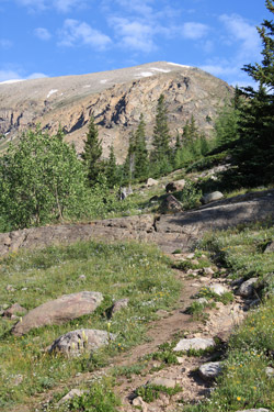
 The Roach route up Mount Oklahoma calls for a departure from the trail to the Halfmoon Lakes at about 11,600 or so . . . but we saw no reason to bushwhack through any terrain below tree line and after getting to about 11,800, really saw no reason to take the Roach route at all. To do so, we would have to skirt the nose of Mount Oklahoma and I just did not want to lose the elevation needed to get across the creek coming from the lakes. Instead we went to the lowest Halfmoon Lake and cut around it to get a look at a grassy east flank slope just to the west of the lowest lake. Yes, that would be our route, in lieu of the suggested course on the opposite side of the ridge. From a distance it looked quite doable and once we circumnavigated the lake, we saw that it would indeed provide a route ranging from class 1 to class 2+, at most, all the way to the ridge. We were off and climbing . . . The Roach route up Mount Oklahoma calls for a departure from the trail to the Halfmoon Lakes at about 11,600 or so . . . but we saw no reason to bushwhack through any terrain below tree line and after getting to about 11,800, really saw no reason to take the Roach route at all. To do so, we would have to skirt the nose of Mount Oklahoma and I just did not want to lose the elevation needed to get across the creek coming from the lakes. Instead we went to the lowest Halfmoon Lake and cut around it to get a look at a grassy east flank slope just to the west of the lowest lake. Yes, that would be our route, in lieu of the suggested course on the opposite side of the ridge. From a distance it looked quite doable and once we circumnavigated the lake, we saw that it would indeed provide a route ranging from class 1 to class 2+, at most, all the way to the ridge. We were off and climbing . . .
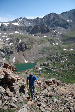
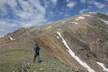
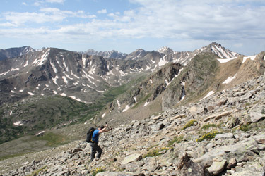 The grassy swale that marks the route we took made for a gentle climb, heading directly toward the ridge and effectively topping out at the high point of a cleft that marks the southern flank of the peak. From the top of the cleft, the route zigs north a bit and climbs to the false ridge line, after which we climbed another 75 feet of vertical to land atop the smooth ridge just shy of the point where Roach's Southeast slopes route gains the ridge from the opposite side. We were observed for part of our climb by a solitary mountain goat who departed for the Mt. Massive connecting ridge in lieu of waiting to form a photogenic backdrop to a shot of Mount Oklahoma's summit. We walked the gentle ridge to the start of the summit slope, the start of the last hump between us and the summit proper. The grassy swale that marks the route we took made for a gentle climb, heading directly toward the ridge and effectively topping out at the high point of a cleft that marks the southern flank of the peak. From the top of the cleft, the route zigs north a bit and climbs to the false ridge line, after which we climbed another 75 feet of vertical to land atop the smooth ridge just shy of the point where Roach's Southeast slopes route gains the ridge from the opposite side. We were observed for part of our climb by a solitary mountain goat who departed for the Mt. Massive connecting ridge in lieu of waiting to form a photogenic backdrop to a shot of Mount Oklahoma's summit. We walked the gentle ridge to the start of the summit slope, the start of the last hump between us and the summit proper.
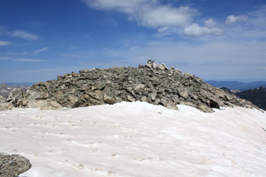 The last 400 to 500 feet of climb was little more than a class 1+ hike with some rock hopping here and there to keep the terrain from being without character whatsoever. I think we both stopped 5 or 6 times over the course of the climb, I was in no hurry and taking pictures while G worked to get his mountain feet back and begin the process of regaining what we both refer to as being in "mountain shape." We reached the apparent summit, which is in fact a false summit but after crossing 25 feet of compact snow, we added an extra eight or ten feet of vertical to stand atop the summit proper. No trail on our route, no cotton and we'd done it in just 3 hours from the truck. We took a short break and left the salutary gummy worm atop the summit to ensure the grace of Pachamama for our trip back to the truck. The last 400 to 500 feet of climb was little more than a class 1+ hike with some rock hopping here and there to keep the terrain from being without character whatsoever. I think we both stopped 5 or 6 times over the course of the climb, I was in no hurry and taking pictures while G worked to get his mountain feet back and begin the process of regaining what we both refer to as being in "mountain shape." We reached the apparent summit, which is in fact a false summit but after crossing 25 feet of compact snow, we added an extra eight or ten feet of vertical to stand atop the summit proper. No trail on our route, no cotton and we'd done it in just 3 hours from the truck. We took a short break and left the salutary gummy worm atop the summit to ensure the grace of Pachamama for our trip back to the truck.
 We reversed our course to the saddle but then opted to take the Roach route back to the base of the peak. The track off the summit ridge is a braided scree trail and I was very content that we opted not to use that route for the ascent. I would have cussed it the whole way up without a doubt as two steps up and one down would have been the best description. Once below the scree slope, we walked the gentle green slopes until we hit the tree line and started to bushwhack through light forest and then through heavy dead fall to intersect the trail somewhere below. We made two stream crossings on rocks and logs and generally traversed toward Mt. Massive to intercept the trail at a point where it runs atop a rounded hump of granite. No route finding issues, just a case of dropping until the woods got thick and then traversing to a known trail . . . Boy Scout stuff. From our trail intercept, it was just a didy bop to the truck and on back down the track to Leadville, to Dillon and to a 2 hour traffic back-up that evaporated, as usual, at the far end of the Idaho Springs tunnels. We reversed our course to the saddle but then opted to take the Roach route back to the base of the peak. The track off the summit ridge is a braided scree trail and I was very content that we opted not to use that route for the ascent. I would have cussed it the whole way up without a doubt as two steps up and one down would have been the best description. Once below the scree slope, we walked the gentle green slopes until we hit the tree line and started to bushwhack through light forest and then through heavy dead fall to intersect the trail somewhere below. We made two stream crossings on rocks and logs and generally traversed toward Mt. Massive to intercept the trail at a point where it runs atop a rounded hump of granite. No route finding issues, just a case of dropping until the woods got thick and then traversing to a known trail . . . Boy Scout stuff. From our trail intercept, it was just a didy bop to the truck and on back down the track to Leadville, to Dillon and to a 2 hour traffic back-up that evaporated, as usual, at the far end of the Idaho Springs tunnels.
|
