|
|---|
St. Vrain PeakFebruary 3, 2008 & February 2007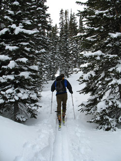
We have skied St. Vrain Peak twice, once from the summit and later from the edge of the krumholz not far above the edge of the trees. It is a great ski and climb, located not a far out of Lyons, Colorado in the Indian Peaks Wilderness. The trail takes off from just above the hamlet of Allen's Park on the road between Lyons and Estes Park. The route is rated as intermediate, more or less, and provides a good ski, if you have decent ski legs. I had my ski legs for one trip but not for another. On both trips we took off from Cheyenne at between 6 and 7 in the a.m. and made the leisurely drive down the Interstate to just north of Longmont and cut west to the town of Lyons. We passed through town and took the dozen plus mile trip on up into the foothills to the cut off to Allen's Park, then on through Allen's Park to the trail head above town. The trail head is lower than the one for the summer trial and is located at a Y intersection where the signage directs one to go further up to the summer start of the trail. We parked at the Y and took the left branch which first descends and then climbs steadily toward tree line.
Admittedly, our second cross country route took a bit more effort as there was no packed trail, just the ski tracks of another group ahead of us. After a few hundred yards of skinning along the other's track, we realized their track was a descending track through the trees and that to continue we would have to take on some serious hill climbing. No problem, we were in no hurry and a little leg burning exercise was not outside the anticipated program. We had been to the tree line of the peak before and we knew that our upward track would cut the regular trail, somewhere up above.
The ski out the road/trail is a pleasure as there is sufficient room for tight turns and opportunities for shortcuts through the relatively open trees for those interested. Our run was over soon enough as we were too quickly back at the end of the road turnaround, after which the grade lessens and one can pole along the road at 15 mph with little effort at all. A few minutes at that pace delivered us back to the base of the short climb to the car and the close of both St. Vrain ski days.
|

 The left branch is a summer road and after the first drop, it makes a hairpin turn before starting to steadily climb. Until the summer road block berm is reached, after a half mile or so, the road is wide and I've always found it well packed and a good skin or ski. No challenge actually in either direction but a good way to warm up for the steeper sections to come. After the road block berm, in a hard to miss turnaround, the road narrows and starts a steeper climb toward the tree line a good distance away. We skinned the road on both trips, sticking to the road proper on the first climb and then on our second climb, we cut off a number of hair hairpin turns in the upper reaches by cutting cross country through the trees.
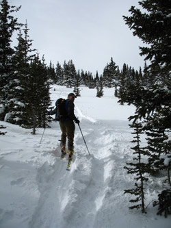
  We bushwhacked along our predecessor's route and eventually cut the standard route, which we took for a few hundred yards to the tree line above. The pine forest gave way on both trips to a tree studded and very deep powder filled glade that we skinned through to the flatter krumholz above. This is the decision point where one seems to choose a rocky traverse across a rock strewn plateau or turn the climb to enjoy the ski back down on legs left un-drained by the climb to the summit proper. On our first trip we took the summit challenge and crossed the expanse of rock and juniper to the head of the draw one first crossed at the bottom road just after leaving the parking area.
 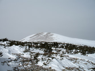 From the top of the draw, the route to the summit is clear, just climb along the ridge to the summit proper which is really not that far above. The summit proper is just a bit past what you may think is the top but soon enough, one is on the true summit. On our first trip, we took a bite to eat, pulled the skins off the skis and made our way slightly to the north to ski along the edge of the large bowl that would deliver us back to the rocky plateau. On our second ascent, the wind was blowing hard and the avalanche conditions were not favorable to skiing the bowl below the summit, so we turned the ski and settled for a wonderful ski back down through he powder filled meadow and onto the well traveled trail below.