Pacific & Atlantic Peaks (combination)
August 2, 2008 - Pacific Peak West Ridge (ascent) & Atlantic West Ridge (descent) from Mayflower Gulch
I had the west ridge of Pacific Peak on my tick list for a number of years but had not had the opportunity to yet make the climb. Two weeks before, G and I did a great ridge climb on Mount Bancroft; but Bob did not have the opportunity to come along for that wonderful bit of class 4 climbing with an 80 foot rappel thrown in for good measure. I wanted to get out again and Bob was recently back from a climbing trip in Kentucky that whetted his appetite for a pitch or two of airy rock above tree line. I thought that the combination of Atlantic and Pacific would provide just the right amount of climbing for a day out with some class 3 and 4 rock thrown in. I thought there might be a chance to add Crystal Peak into the mix but it turned out the the Pacific/Atlantic/towering clouds/thunder combination kept us to two peaks that day.
 I'm getting older and I readily admit that my alpine start is slowly failing so I suggested to Bob that we not leave Cheyenne at an unreasonable hour in the morning but instead leave at 6 pm the night before and pitch the tent in the parking lot at the start of the 4wd track up Mayflower Gulch. We did just that and by 9:45 the tent was up, the air mattress inflated and my sleeping bag was lofting. The night sky had a touch of mixed clouds but the big dipper was overhead and all seemed to promise good climbing weather the next morning. I set the alarm for 5 am. I'm getting older and I readily admit that my alpine start is slowly failing so I suggested to Bob that we not leave Cheyenne at an unreasonable hour in the morning but instead leave at 6 pm the night before and pitch the tent in the parking lot at the start of the 4wd track up Mayflower Gulch. We did just that and by 9:45 the tent was up, the air mattress inflated and my sleeping bag was lofting. The night sky had a touch of mixed clouds but the big dipper was overhead and all seemed to promise good climbing weather the next morning. I set the alarm for 5 am.
 The air mattress seems to have a pinhole leak and by 4:59 I was suffering from a bit of back ache from the softening mattress. My butt was not touching the pavement, but it was soft enough to either put in a bit of air or get up. As I considered the possibilities, the alarm went off and I think we both were ready to get going. The packs were put in order the prior night and the morning was so warm that a layer beyond a poly tee was really not necessary. We were off on our way by 5:30, hoofing our way up the dark 4wd track to a point just over a mile up the gulch where I planned to cut east to begin the slog to the base of Pacific's west ridge. We chatted and walked as the sun started to come up and the skies lightened enough to stow the headlamps. The air mattress seems to have a pinhole leak and by 4:59 I was suffering from a bit of back ache from the softening mattress. My butt was not touching the pavement, but it was soft enough to either put in a bit of air or get up. As I considered the possibilities, the alarm went off and I think we both were ready to get going. The packs were put in order the prior night and the morning was so warm that a layer beyond a poly tee was really not necessary. We were off on our way by 5:30, hoofing our way up the dark 4wd track to a point just over a mile up the gulch where I planned to cut east to begin the slog to the base of Pacific's west ridge. We chatted and walked as the sun started to come up and the skies lightened enough to stow the headlamps.
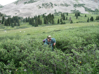
 We made the cut east just beyond the mile mark, same place as G and I cut east six years before on our attempt to climb the west ridge of Atlantic Peak in December. The snow took care of the traverse through the willows many years before but today we had to negotiate a track through the head high willows. But before we got to the willows, we had to cross several marshy areas where my only goal was to ensure that I got across to the other side with dry feet. I was using my low top approach shoes and what I sure did not want was to dip one into some mud hole at the start of the climb. We bushwhacked through the willows and happened to hit the stream at a spot where there were a few perfectly placed rocks. We were across with dry feet. it was not over, however, as we then bushwhacked through more willows for the nearest pine tree, where I knew the willows would relent and we could work our way up through the forest. We made the cut east just beyond the mile mark, same place as G and I cut east six years before on our attempt to climb the west ridge of Atlantic Peak in December. The snow took care of the traverse through the willows many years before but today we had to negotiate a track through the head high willows. But before we got to the willows, we had to cross several marshy areas where my only goal was to ensure that I got across to the other side with dry feet. I was using my low top approach shoes and what I sure did not want was to dip one into some mud hole at the start of the climb. We bushwhacked through the willows and happened to hit the stream at a spot where there were a few perfectly placed rocks. We were across with dry feet. it was not over, however, as we then bushwhacked through more willows for the nearest pine tree, where I knew the willows would relent and we could work our way up through the forest.
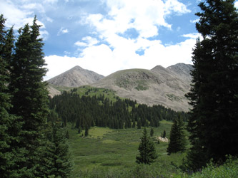
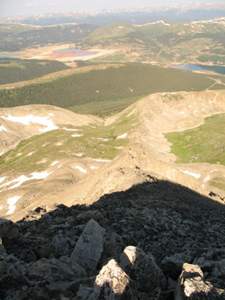 The route to the base of the west ridge of Pacific does not require any navigation skill as you are looking right at the ridge from the very point where you drop off the road. Once across the gulch and creek, the idea is to cut up through the narrower gully that brings Pacific Creek down from a snowfield at the base of the peak's west ridge. Rather than negotiate the stream course, we worked our way up the left flank of the draw and gained elevation quickly rather than by chasing the stream. This strategy allowed for us to get onto the high meadow and make an unencumbered traverse to the base of the ridge. After gaining the upper reaches of the meadow, we took a Goo break, looked at the route up the ridge, and hypothesized about the correct line. The route to the base of the west ridge of Pacific does not require any navigation skill as you are looking right at the ridge from the very point where you drop off the road. Once across the gulch and creek, the idea is to cut up through the narrower gully that brings Pacific Creek down from a snowfield at the base of the peak's west ridge. Rather than negotiate the stream course, we worked our way up the left flank of the draw and gained elevation quickly rather than by chasing the stream. This strategy allowed for us to get onto the high meadow and make an unencumbered traverse to the base of the ridge. After gaining the upper reaches of the meadow, we took a Goo break, looked at the route up the ridge, and hypothesized about the correct line.
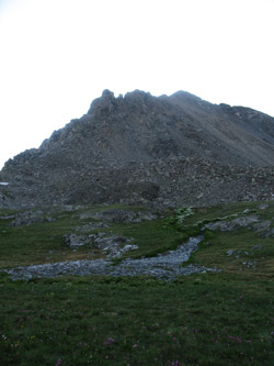
 I'd read a few trip reports that gave some hints but the route seemed pretty straight forward. We looped north to gain the toe of the ridge and started up the first section by boulder hopping and picking our way through large talus that skirted the southern edge of the ridge. I'd read of a dirty trough that was not to be followed to the ridge crest proper or one would end up on the ridge proper proper but cut off by much terrain higher than the class 3 difficulty advertised for this climb. We climbed for about 20 minutes and found ourselves in that previously described dirty red trough . . . faced with a down climb to traverse below the ridge line or a climb up another hundred feet or so the the gap we had seen from below. The gap was indeed the ridge line but the uphill side presented a clear class 4/5 exit . . . we took it and decided that we would make a go of the ridge line proper unless forced off by overly technical terrain. I'd read a few trip reports that gave some hints but the route seemed pretty straight forward. We looped north to gain the toe of the ridge and started up the first section by boulder hopping and picking our way through large talus that skirted the southern edge of the ridge. I'd read of a dirty trough that was not to be followed to the ridge crest proper or one would end up on the ridge proper proper but cut off by much terrain higher than the class 3 difficulty advertised for this climb. We climbed for about 20 minutes and found ourselves in that previously described dirty red trough . . . faced with a down climb to traverse below the ridge line or a climb up another hundred feet or so the the gap we had seen from below. The gap was indeed the ridge line but the uphill side presented a clear class 4/5 exit . . . we took it and decided that we would make a go of the ridge line proper unless forced off by overly technical terrain.
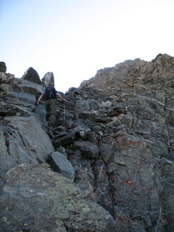
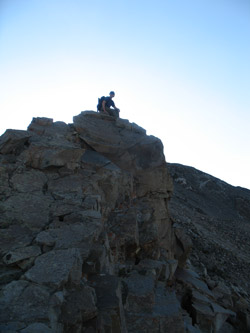
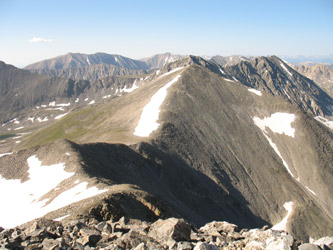 We made our way up the ridge, climbing up and over the pinnacles as we came to them. We had a few solid class 4/5 moves with serious exposure to a long fall to either side. There were go around routes off to the south side of the ridge, but we were comfortable and stuck to the ridge proper. The terrain has a lot of knife edge terrain and there were numerous small bumps that presented class 4 terrain, with substantial exposure in the event of a slip. The ridge remained challenging until there is but perhaps 300 feet of gain left to summit, at which point the difficulty lessens to class2+ and the exposure became an insubstantial issue for us. Then, just before the summit we came to a cleft that is actually the exit of the north couloir where for a moment I wondered just how we would ross the last gulf. But a second glance yielded a simple down climb from the false summit before the last 50 feet of climb to the rounded true summit. We made our way up the ridge, climbing up and over the pinnacles as we came to them. We had a few solid class 4/5 moves with serious exposure to a long fall to either side. There were go around routes off to the south side of the ridge, but we were comfortable and stuck to the ridge proper. The terrain has a lot of knife edge terrain and there were numerous small bumps that presented class 4 terrain, with substantial exposure in the event of a slip. The ridge remained challenging until there is but perhaps 300 feet of gain left to summit, at which point the difficulty lessens to class2+ and the exposure became an insubstantial issue for us. Then, just before the summit we came to a cleft that is actually the exit of the north couloir where for a moment I wondered just how we would ross the last gulf. But a second glance yielded a simple down climb from the false summit before the last 50 feet of climb to the rounded true summit.
 Pacific in hand . . . it was time for the ceremonial gummi worms, a sip of Cytomax, and a few minute's rest before we started the crossing to Atlantic. The local marmot came to scope us out and we left the obligatory gummi worm on the highest rock for Pachamama. I suspect she may have taken the form of a marmot that morning . . . We had made the summit in just 3 1/2 hour from the car and after a bit of lounging, we stowed the gorp and hefted the packs to head for Atlantic's summit, perhaps 3/4 mile distant. Pacific in hand . . . it was time for the ceremonial gummi worms, a sip of Cytomax, and a few minute's rest before we started the crossing to Atlantic. The local marmot came to scope us out and we left the obligatory gummi worm on the highest rock for Pachamama. I suspect she may have taken the form of a marmot that morning . . . We had made the summit in just 3 1/2 hour from the car and after a bit of lounging, we stowed the gorp and hefted the packs to head for Atlantic's summit, perhaps 3/4 mile distant.
The connecting ridge is just class 1 & 2 territory and there is more or less a trail between the summits. I expected the crossing would take an hour and that is just about how long it took us. The route dropped off from the summit of Pacific, down through a talus slope then up and over two intermediate points before arriving at the lowest point between the peaks. From there is was a steady uphill on talus to the second summit of the day. Another sip and Goo but we also took time to scope out the very rugged ridge that connects Atlantic to Fletcher. I've never read any reports of folks crossing this gendarme 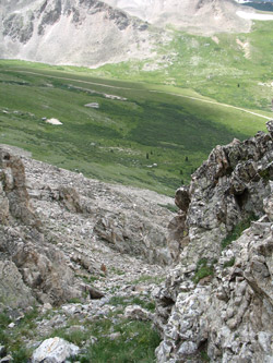 studded ridge but of course I know folks have done it. Bob and I looked at the route and thought there has to be a doable class 4 route between those two summits, if you have the time to pick your way across and the weather cooperates. studded ridge but of course I know folks have done it. Bob and I looked at the route and thought there has to be a doable class 4 route between those two summits, if you have the time to pick your way across and the weather cooperates.
We descended Atlantic via its west ridge and within just 100 yards came to the stopping point of the winter attempt G and I had made almost six years earlier. This time there was just a remnant of the cornice and avalanche slope that so effectively stopped our upward progress on that cold December morning. We made good time down the ridge, sticking to the ridge proper for the whole of the descent to the rounded over hummock that forms the lowest part of the ridge. Our morning crossing through the willows was a traverse I did not really want to repeat so I suggested dropping off to the south side of the ridge to cross the most narrow section of willows and arrive at the mine cabins at the summer 4wd road closure gate.
 I knew to be cautious of cliffs as I remembered that most of the west ridge is cliffy at the base but I figured we had descended enough to avoid the worst of the vertical terrain. Not so, instead I managed to find that one point where a narrow and jagged cleft allows passage down through the cliff band to land us on a steep talus fan rather than a some more easily negotiated slope. I should have known to just come all the way off the ridge and then cut back up to gain the easier willow traverse but no we slogged our way down that seemingly endless and very loose talus fan. Finally, we hit the grass just in time for a bit of rain and far away thunder. We crossed to the cabin and then hoofed our way down the mile and a quarter of road without a second thought. Total trip time was about 7 1/2 hours portal to portal. I knew to be cautious of cliffs as I remembered that most of the west ridge is cliffy at the base but I figured we had descended enough to avoid the worst of the vertical terrain. Not so, instead I managed to find that one point where a narrow and jagged cleft allows passage down through the cliff band to land us on a steep talus fan rather than a some more easily negotiated slope. I should have known to just come all the way off the ridge and then cut back up to gain the easier willow traverse but no we slogged our way down that seemingly endless and very loose talus fan. Finally, we hit the grass just in time for a bit of rain and far away thunder. We crossed to the cabin and then hoofed our way down the mile and a quarter of road without a second thought. Total trip time was about 7 1/2 hours portal to portal.
|
