Mt. Wilson & El Diente Peak
Mt. Wilson North Face & Connecting to El Diente
July 6, 2002 and August 22, 2011
I've made this climb and traverse twice, once with G when I was working my way through my final 14'ers and again nine years later with Ed as he worked his way through his final 14'ers. The routine was the same both times as G and I had climbed Wilson Peak the day before and Ed and I knocked off both Gladstone and Wilson Peak on our pre traverse conditioning climb. Our climbs were functionally identical, hence I'll cover the more recent climb for no reason other than the photos from the more recent climb are better.
 We left the new Silverpick trail head at 2:30 in the a.m. figuring to cover the 3.7 miles from trail head through the Rock of Ages saddle and beyond in the dark. No need to waste daylight on this familiar track and on the previous day, the clouds had started to build by 9 a.m. We knew we'd have to cover ground if we wanted to ensure that we'd not get caught out on the ridge to El Diente with thunderheads looming above us. We were blessed with a warm morning and a total lack of wind. I do not normally expect such conditions; I've been living in Wyoming for 12 years now and I am just conditioned to every day being a cold and windy day. So with that in mind . . . I go to the mountains, forget my shorts and assume a cold wind to We left the new Silverpick trail head at 2:30 in the a.m. figuring to cover the 3.7 miles from trail head through the Rock of Ages saddle and beyond in the dark. No need to waste daylight on this familiar track and on the previous day, the clouds had started to build by 9 a.m. We knew we'd have to cover ground if we wanted to ensure that we'd not get caught out on the ridge to El Diente with thunderheads looming above us. We were blessed with a warm morning and a total lack of wind. I do not normally expect such conditions; I've been living in Wyoming for 12 years now and I am just conditioned to every day being a cold and windy day. So with that in mind . . . I go to the mountains, forget my shorts and assume a cold wind to 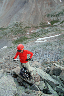 be part of every climbing day, even a summer day. Well, the predawn weather was perfect and we hiked the familiar route in just about 2 and a half hours, putting us at the Rock of Ages saddle at a bit after 5 in the a.m. be part of every climbing day, even a summer day. Well, the predawn weather was perfect and we hiked the familiar route in just about 2 and a half hours, putting us at the Rock of Ages saddle at a bit after 5 in the a.m.
No sense wasting time on the saddle, we set out immediately to drop into the basin that lies below Mt. Wilson and El Diente. I'd considered a traverse to avoid losing elevation but by the time one hops from rock to rock for all too long, you might as well just take the trail to the creek at the bottom of 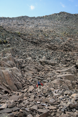 the valley, cross a bit of a boggy stretch and then just take on the most direct route up Mt. Wilson. We hiked down to the mine pad and greeted the two fellows in the tent pitched on the waste pile. We had spoken at length with them the night before as we came out from Wilson Peak and as they were preparing to hike in to spend a day or two in the upper basin ticking the Wilsons off their own 14'er lists. the valley, cross a bit of a boggy stretch and then just take on the most direct route up Mt. Wilson. We hiked down to the mine pad and greeted the two fellows in the tent pitched on the waste pile. We had spoken at length with them the night before as we came out from Wilson Peak and as they were preparing to hike in to spend a day or two in the upper basin ticking the Wilsons off their own 14'er lists.
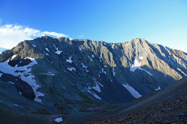
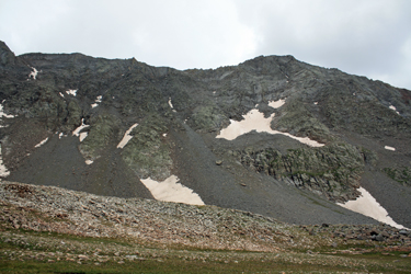
We took the standard trail from the saddle to nearly the bottom before we cut off and across relatively flat ground to the stream below. We had decided to go light as to water so we both filled our camel backs and moved off toward the base of a wide ridge that lead up toward the summit of Mt. Wilson, probably every bit of 1800 feet above us. I assumed there was a trail as I did not recall any real route finding issue from years before so I just led right up the crest of the ridge figuring to intercept the trail along the way.
 The route started out as one of hummocks and grass and after just a short bit, I hit the trail I now recalled would lead across this lower angled ground to the rocky part of the climb above. We cut back and forth, staying on strong trail segments until we hit the challenging part of the ridge. The ridge transitioned from grass and hummocks to a boulder strewn flank where boulder hopping was the means of gaining altitude. There were cairns here and there but the center third of the climb up the flank of the pek was pretty much a boulder pile interspersed with stronger pitches where class 3 and a bit of class 4 climbing came into play. We scrambled through the tougher sections, picking and choosing a traverse here or there to hold the ground to class 3 before the slope lessened and the climb again changed character. The route started out as one of hummocks and grass and after just a short bit, I hit the trail I now recalled would lead across this lower angled ground to the rocky part of the climb above. We cut back and forth, staying on strong trail segments until we hit the challenging part of the ridge. The ridge transitioned from grass and hummocks to a boulder strewn flank where boulder hopping was the means of gaining altitude. There were cairns here and there but the center third of the climb up the flank of the pek was pretty much a boulder pile interspersed with stronger pitches where class 3 and a bit of class 4 climbing came into play. We scrambled through the tougher sections, picking and choosing a traverse here or there to hold the ground to class 3 before the slope lessened and the climb again changed character.
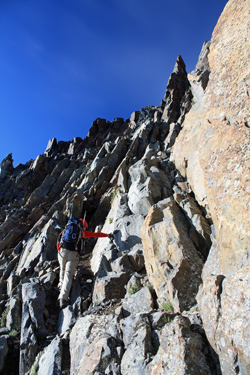 We nexte encountered trail segments mixed with scree runnels, offered up with an occasional boulder pile. This was the name of the game for another couple of hundred vertical feet before the route achieved the ridge top proper and we began the climber's right traverse toward the summit. The fact that we were nearing the elevation of the summit did little to make for easier ground, instead we traversed along the side of the ridge, at one point climbing through a narrow pass and then around on a short ledge to bring us to the notch that separates the approach portion of the ridge from the summit climb proper. We nexte encountered trail segments mixed with scree runnels, offered up with an occasional boulder pile. This was the name of the game for another couple of hundred vertical feet before the route achieved the ridge top proper and we began the climber's right traverse toward the summit. The fact that we were nearing the elevation of the summit did little to make for easier ground, instead we traversed along the side of the ridge, at one point climbing through a narrow pass and then around on a short ledge to bring us to the notch that separates the approach portion of the ridge from the summit climb proper.
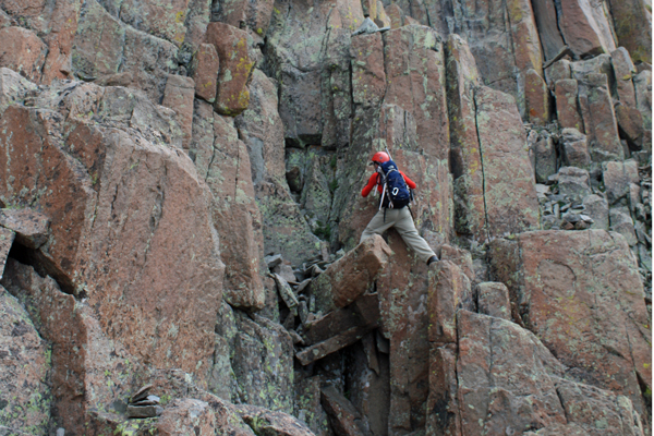
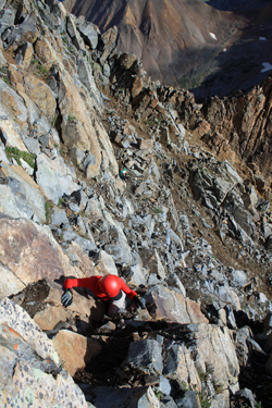 The summit was going to be reached by a class 4 climb pretty much no matter what route we took. Ed scoped out the ridge running option but with well over 100 feet of exposure if one slips, he opined that the cat crawl method of summiting was not his bag. So I suggested that we drop down a short gully that grants passage across a fin to a class 4 pitch that works up through a series of ledges and short pitches to the summit. We dropped the packs and scrambled to the top, ticking another 14'er summit from Ed's list and giving me yet another second trip up one of the harder 14'ers. We spent perhaps 3 minutes on the summit before reversing our route down and back through the ledgy area to the gap in the summit ridge that gives the first view of El Diente and the connecting ridge. The summit was going to be reached by a class 4 climb pretty much no matter what route we took. Ed scoped out the ridge running option but with well over 100 feet of exposure if one slips, he opined that the cat crawl method of summiting was not his bag. So I suggested that we drop down a short gully that grants passage across a fin to a class 4 pitch that works up through a series of ledges and short pitches to the summit. We dropped the packs and scrambled to the top, ticking another 14'er summit from Ed's list and giving me yet another second trip up one of the harder 14'ers. We spent perhaps 3 minutes on the summit before reversing our route down and back through the ledgy area to the gap in the summit ridge that gives the first view of El Diente and the connecting ridge.
 I'd crossed the ridge from Wilson to El Diente nine years before and remembered most of the route, at least as to the general concept of what to expect. I recalled that the traverse really came in three parts. The first was the ridge from Mt. Wilson to a notch at about the one third mark. The guide book tells of a 70 or so foot rappel at the far end of this ridge that will allow one to stay on the ridge proper. I didn't have a rope before and I didn't have one this time either but for a 50 foot "oh crap" save your tail shorty. The game plan therefore called for us to take the descending slot down to the base of the ridge, a drop of a hundred or, at the most, two hundred feet, from which we would traverse along the lower edge of the ridge's verticality until we came to the slot, where we would climb back up to the ridge proper. I'd crossed the ridge from Wilson to El Diente nine years before and remembered most of the route, at least as to the general concept of what to expect. I recalled that the traverse really came in three parts. The first was the ridge from Mt. Wilson to a notch at about the one third mark. The guide book tells of a 70 or so foot rappel at the far end of this ridge that will allow one to stay on the ridge proper. I didn't have a rope before and I didn't have one this time either but for a 50 foot "oh crap" save your tail shorty. The game plan therefore called for us to take the descending slot down to the base of the ridge, a drop of a hundred or, at the most, two hundred feet, from which we would traverse along the lower edge of the ridge's verticality until we came to the slot, where we would climb back up to the ridge proper.
 The route was a bit muddy so we took care in descending down the narrows, hugging one side or the other to allow for some grips here and there in addition to the judicious use of our hiking poles. The descent was a bit steep but at the bottom it mellows and drops one at the upper end of a few year long snowfields that we skirted the upper edges of. The ground along the base of the ridge is class 2 and presented us with little challenge but for a short hump back up to the notch mentioned earlier. The route was a bit muddy so we took care in descending down the narrows, hugging one side or the other to allow for some grips here and there in addition to the judicious use of our hiking poles. The descent was a bit steep but at the bottom it mellows and drops one at the upper end of a few year long snowfields that we skirted the upper edges of. The ground along the base of the ridge is class 2 and presented us with little challenge but for a short hump back up to the notch mentioned earlier.
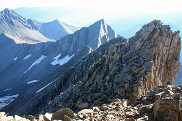
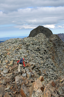 The notch represents what I'd call the middle third of the traverse, where the route follows the ridge top proper for a bit. From the notch we picked our own class 3 scramble to the ridge proper and then we ridge walked, or more properly, ridge hopped from boulder to boulder until we crossed this very straight forward section. The last third of the ridge is the section where one must skirt a series of gendarmes that force you to drop to the climber's left for anywhere from fifty to perhaps 150 feet from the ridge proper. This section is solid class 4 climbing with a number of short ledgy traverses that do not allow one the option to fall and come away unscathed. A mishap in this section will pretty much put you out of action for a long time or forever. We followed a good set of cairns that I remembered from a decade before. The notch represents what I'd call the middle third of the traverse, where the route follows the ridge top proper for a bit. From the notch we picked our own class 3 scramble to the ridge proper and then we ridge walked, or more properly, ridge hopped from boulder to boulder until we crossed this very straight forward section. The last third of the ridge is the section where one must skirt a series of gendarmes that force you to drop to the climber's left for anywhere from fifty to perhaps 150 feet from the ridge proper. This section is solid class 4 climbing with a number of short ledgy traverses that do not allow one the option to fall and come away unscathed. A mishap in this section will pretty much put you out of action for a long time or forever. We followed a good set of cairns that I remembered from a decade before.
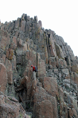 With little trouble we worked our way around the base of the gendarmes, mixing class 3 gully down climbs with class 4 traverses and squeeze arounds until we worked our way back up to the ridge proper, just to arrive at the last notch that defines the start of the El Diente summit block. Our route now took another non ridge top traverse to the climber's right where a well worn trail worked its way through class 3 ground about 50 below the ridge proper. We worked that path until we thought we were below the summit and then we moved upward through a class 3 muddy gully that led us to the ridge proper but still shy of the summit by one down and up climb. We made our last short ten foot down climb into the small pre summit notch and then scrambled up the last bit of ground to the summit blocks. With little trouble we worked our way around the base of the gendarmes, mixing class 3 gully down climbs with class 4 traverses and squeeze arounds until we worked our way back up to the ridge proper, just to arrive at the last notch that defines the start of the El Diente summit block. Our route now took another non ridge top traverse to the climber's right where a well worn trail worked its way through class 3 ground about 50 below the ridge proper. We worked that path until we thought we were below the summit and then we moved upward through a class 3 muddy gully that led us to the ridge proper but still shy of the summit by one down and up climb. We made our last short ten foot down climb into the small pre summit notch and then scrambled up the last bit of ground to the summit blocks.
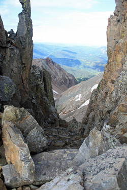
I do not think we were on the summit for more than about 3 or 4 minutes due to the darkening sky that was coming in from the west. I knew that since were not going to traverse back to Mt. Wilson, that we would be down climbing the Colonic Couloir and I wanted no part of that ground in rainy weather. I had been down that gully once before and I knew that since it already 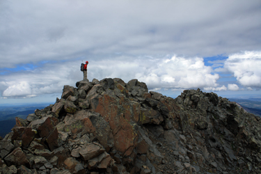 had wet sections of its own making, I didn't want to partake of it with rain added into the mix. We left the summit and climbed back down into the last small notch but did not re-climb to the ridge. Instead we dropped about 30 vertical feet to a notch in a fin that otherwise forms the side of a steep cleft leading downhill and is filled with summer ice. had wet sections of its own making, I didn't want to partake of it with rain added into the mix. We left the summit and climbed back down into the last small notch but did not re-climb to the ridge. Instead we dropped about 30 vertical feet to a notch in a fin that otherwise forms the side of a steep cleft leading downhill and is filled with summer ice.
I knew the summer ice was not our route but I recalled cutting down the gash toward the gap in the fin, after which we would do a short up and down traverse of perhaps 100 yards to bring us to the top of our descent couloir. G and I call this the Colonic Couloir due to the fact that given a choice between down climbing this rubble strewn gully or going into Telluride and 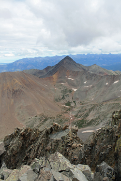 having some dirty braided armpit hair hippie chick give us a Swiss almond mocha (heavy on the shells) colonic, I'd choose the colon flush over another descent down this gully. Regardless, it was descend or re-traverse and I either really did not want to tangle with more class 4 ground that was not required to complete the course like 'em with extra shells. Either way, this descent is painful. having some dirty braided armpit hair hippie chick give us a Swiss almond mocha (heavy on the shells) colonic, I'd choose the colon flush over another descent down this gully. Regardless, it was descend or re-traverse and I either really did not want to tangle with more class 4 ground that was not required to complete the course like 'em with extra shells. Either way, this descent is painful.
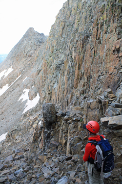
 The descent first crosses fractured granite "slick rock" then degrades into a wide rubble filled couloir that just goes down and down and down. The feet slip left, the feet slip right and the rock seems to all be loose under foot. It is just a damned hard way to lose 1500 feet . . . The descent first crosses fractured granite "slick rock" then degrades into a wide rubble filled couloir that just goes down and down and down. The feet slip left, the feet slip right and the rock seems to all be loose under foot. It is just a damned hard way to lose 1500 feet . . .
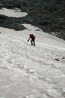
We lost 1000 of those feet before I took the opportunity to cut to the descending right to intercept the top of a snowfield that I figured would be soft at this point in the day. The snow was soft enough to let an elbow and knee arrest be fully functional but still just steep enough to offer a lively run out in the event no arresting effort is made at all.
 I went 50 feet before I got to practice my arrest, a nice fall on teh back/roll to the belly model, actually only the second unanticipated slide in my climbing career. I say unanticipated as I was ready for action but I did not know when along the way that chance would come. Ed followed and got to practice his arrest four times as compared to my one effort. For Ed, it was his first actual arrest on snow, so now he does know that he has a technique that will likely work for him in the event of sudden need. I went 50 feet before I got to practice my arrest, a nice fall on teh back/roll to the belly model, actually only the second unanticipated slide in my climbing career. I say unanticipated as I was ready for action but I did not know when along the way that chance would come. Ed followed and got to practice his arrest four times as compared to my one effort. For Ed, it was his first actual arrest on snow, so now he does know that he has a technique that will likely work for him in the event of sudden need.
At the bottom of the snow we traversed right and then boulder hopped down another 200 vertical feet of talus choked slope before coming to the rock filled base of the valley. I cut further right to find a spot of mixed grass and rock, where I could pick my way through grass to make the short climb to the trail that runs 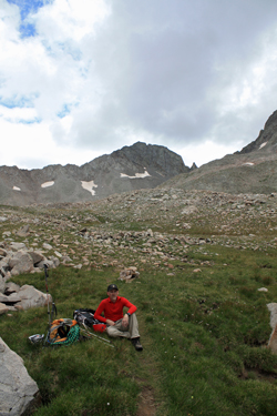 up through the valley to the Rock of Ages saddle. The rain we wanted to avoid was now starting to fall but never really exceeded a light drizzle and even that did not last long. Trust me, had we been in the Colonic Couloir, we'd have gotten dumped on for sure just for the heck of it. We stopped for a short lunch now that our remaining climb would be nothing but class 1 trail hiking and after 15 minute respite, we headed up toward the saddle. up through the valley to the Rock of Ages saddle. The rain we wanted to avoid was now starting to fall but never really exceeded a light drizzle and even that did not last long. Trust me, had we been in the Colonic Couloir, we'd have gotten dumped on for sure just for the heck of it. We stopped for a short lunch now that our remaining climb would be nothing but class 1 trail hiking and after 15 minute respite, we headed up toward the saddle.
At the base of the 1000 foot climb up to the Rock of Ages saddle, we retrieved our water filter, pumped two quarts for each of us and were off for the saddle. We pushed through the 1000 foot climb without stopping and then stopped at the top only long enough to shoot a Gu and then move on to cover the last 3.7 miles to the truck. We'd crossed these same miles 3 times in the last day and a half and were not interested in taking a slow walk to enjoy the course. No, our minds were focused on dinner in Ouray and the sooner we got down the trail to the trail head, the sooner that event would happen. We made good time, arriving back at the trail head at about 5 p.m., having made a non stop power hike all the way.
|
