Emory Peak
Pinnacles/Emory Peak Trail - December 30, 2011
Chisos South Rim Trail - December 31, 2011
Emory Peak Climb . . .
I encountered up to two feet of snow in the Guadalupe Range and after kicking paths and postholing for two days on Guadalupe and Hunter Peaks, I'd had enough as I simply had not gone all the way to Texas to climb in the snow. I had been to Big Bend Park back around1985 but did not have the chance to climb in the Chisos range while there. Seemed like a good place to bail to on the hope that the winter storm that gave Guadalupe its snowy mantle did not make it that far south.
 I drove south from Guadalupe and was pleased to snag a campsite in the Chisos Basin Campground for the New Year's weekend. I figured getting a site might be iffy but the ranger at the gate advised there were 8 left when I came through at about 2 in the afternoon. The campground host wandered over after a while and gave a darned good description of the hikes and trails, followed by a weather commentary that for Texans it would be cold but "beins how you are from Wyomin', don't reckon 30 degrees at night is going to bother you too much." He was correct, I really was not worried about getting cold. I drove south from Guadalupe and was pleased to snag a campsite in the Chisos Basin Campground for the New Year's weekend. I figured getting a site might be iffy but the ranger at the gate advised there were 8 left when I came through at about 2 in the afternoon. The campground host wandered over after a while and gave a darned good description of the hikes and trails, followed by a weather commentary that for Texans it would be cold but "beins how you are from Wyomin', don't reckon 30 degrees at night is going to bother you too much." He was correct, I really was not worried about getting cold.
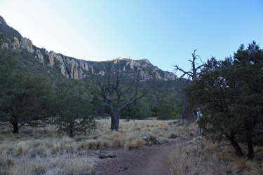
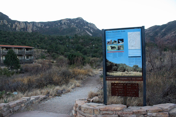
 The trail to Emory Peak leaves from the parking lot for the Chisos Lodge, but I tacked an extra half mile on the front and back of the hike by starting from the campground and hiking on up to the trailhead proper. I got started at about 8 a.m. and knew that it would about an 11 mile day over well maintained trail. I went all of 100 yards before stopping to talk to two guys from the Austin area and we hiked together for the next 3.5 miles, all the way to the juncture of the Emory Peak Trail and the Pinnacles Trail after which we would go our separate ways. The trail to Emory Peak leaves from the parking lot for the Chisos Lodge, but I tacked an extra half mile on the front and back of the hike by starting from the campground and hiking on up to the trailhead proper. I got started at about 8 a.m. and knew that it would about an 11 mile day over well maintained trail. I went all of 100 yards before stopping to talk to two guys from the Austin area and we hiked together for the next 3.5 miles, all the way to the juncture of the Emory Peak Trail and the Pinnacles Trail after which we would go our separate ways.
 These guys had hiked all over the southwest and had a good number of Colorado 14'er under their belts as well. We swapped hiking stories and suggested routes for the next hour and a half. The trail initially looped around the staff residences for the Lodge before coming to the upper most part of the developed area, where the hike really began. The trail never offered a steep section but just gently climbed first through piney woods and meadows and then up along the flank of Emory Peak. There was a CCC camp located in the Chisos Basin from 1933 through 1942 and I have the strongest of hunches that is the reason why the trail is so well constructed and graded. These guys had hiked all over the southwest and had a good number of Colorado 14'er under their belts as well. We swapped hiking stories and suggested routes for the next hour and a half. The trail initially looped around the staff residences for the Lodge before coming to the upper most part of the developed area, where the hike really began. The trail never offered a steep section but just gently climbed first through piney woods and meadows and then up along the flank of Emory Peak. There was a CCC camp located in the Chisos Basin from 1933 through 1942 and I have the strongest of hunches that is the reason why the trail is so well constructed and graded.
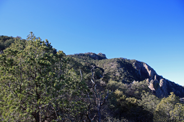
 We made steady time up the path for about two hours before arriving at the final switchbacks before the start of the trail to the summit of the peak and the cut off for the trail to the South Rim of the Chisos Range. At this point, we parted company and I was off for the summit, solo. The summit trail appears to have been recently relocated to the opposite flank of the mountain and once again, a steady grade rather than steep climb is the name of the game. Once the trail cut to the back side of the peak, the summit, with its radio towers, came into view and within perhaps 45 minutes, I was at the base of the granite outcrop that forms the summit proper. Gaining the summit takes a class 3 move or two, but with a reasonable degree of climbing ability, one is soon atop the peak. We made steady time up the path for about two hours before arriving at the final switchbacks before the start of the trail to the summit of the peak and the cut off for the trail to the South Rim of the Chisos Range. At this point, we parted company and I was off for the summit, solo. The summit trail appears to have been recently relocated to the opposite flank of the mountain and once again, a steady grade rather than steep climb is the name of the game. Once the trail cut to the back side of the peak, the summit, with its radio towers, came into view and within perhaps 45 minutes, I was at the base of the granite outcrop that forms the summit proper. Gaining the summit takes a class 3 move or two, but with a reasonable degree of climbing ability, one is soon atop the peak.
 There was a group of four ahead of me but they left after a bit and I had the top to myself. I took some photos, ate lunch, and upon the arrival of three "he man rah-rah boys", figured the bullshit would soon cover the summit so it was time to go back down. I descended the granite pitch and soon enough was on my way back to camp, a hike of 5.1 miles or so. A bit over two hours later, I was back at the truck, sitting in the late afternoon sun and killing time until dinner and the oh too early sunset which is the bane of the winter camping scene. There was a group of four ahead of me but they left after a bit and I had the top to myself. I took some photos, ate lunch, and upon the arrival of three "he man rah-rah boys", figured the bullshit would soon cover the summit so it was time to go back down. I descended the granite pitch and soon enough was on my way back to camp, a hike of 5.1 miles or so. A bit over two hours later, I was back at the truck, sitting in the late afternoon sun and killing time until dinner and the oh too early sunset which is the bane of the winter camping scene.
Chisos South Rim Hike . . .
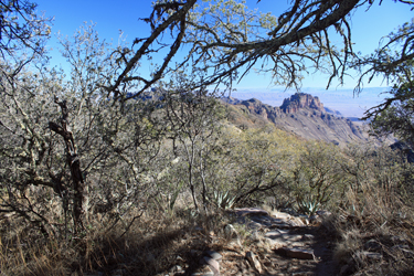
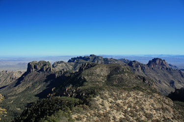
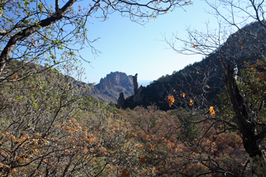 While not a climb proper, the South Rim Trail in the Chisos puts the climb of Emory Peak to shame. The South Rim trail system skirts the edge of the south rim of the Chisos escarpment, providing views of the south of the park as well as across the river into Mexico. The hike begins at the Chisos Lodge parking lot and I chose to start the hike on the now familiar Pinnacles Trail, once again leading to the juncture with the Emory Peak Trail. Like the fellows I started off with the prior morning, I then cut off on the Boot Canyon Trail that skirts the northwest flank of Emory Peak and provides a great view of Boot Rock, an outcrop that appears in the shape of an upturned boot. The trail passes the juncture of the Juniper Canyon Trail and then leads through the upper reaches of Juniper Canyon until reaching the lower juncture with the Northeast Rim Trail. While not a climb proper, the South Rim Trail in the Chisos puts the climb of Emory Peak to shame. The South Rim trail system skirts the edge of the south rim of the Chisos escarpment, providing views of the south of the park as well as across the river into Mexico. The hike begins at the Chisos Lodge parking lot and I chose to start the hike on the now familiar Pinnacles Trail, once again leading to the juncture with the Emory Peak Trail. Like the fellows I started off with the prior morning, I then cut off on the Boot Canyon Trail that skirts the northwest flank of Emory Peak and provides a great view of Boot Rock, an outcrop that appears in the shape of an upturned boot. The trail passes the juncture of the Juniper Canyon Trail and then leads through the upper reaches of Juniper Canyon until reaching the lower juncture with the Northeast Rim Trail.
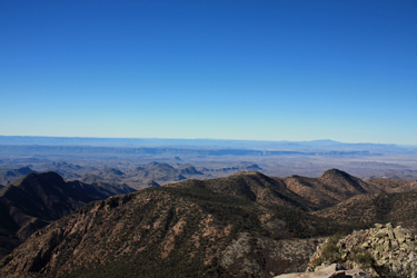
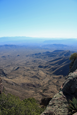 The Northeast Rim Trail climbed for about a mile and a half before coming to the rim proper. Now the scenery gets good as the trail skirts the edge of the rim, granting views of the Chihuahuan desert plains, Rio Grande and the mountains of northern Mexico. The hike extends along the cliffs for about 1.5 miles before coming to the terminus of the Boot Canyon Trail. I The Northeast Rim Trail climbed for about a mile and a half before coming to the rim proper. Now the scenery gets good as the trail skirts the edge of the rim, granting views of the Chihuahuan desert plains, Rio Grande and the mountains of northern Mexico. The hike extends along the cliffs for about 1.5 miles before coming to the terminus of the Boot Canyon Trail. I 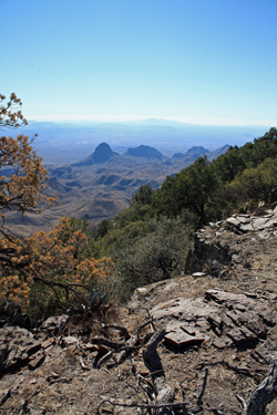 chose to extend the rim walk so I took the Southwest Rim Trail another half mile to the northernmost point on the rim. I'd now covered a bit over 8 miles miles and stopped for lunch at about 11:30, having the entire southern expanse of the park laid out before me. chose to extend the rim walk so I took the Southwest Rim Trail another half mile to the northernmost point on the rim. I'd now covered a bit over 8 miles miles and stopped for lunch at about 11:30, having the entire southern expanse of the park laid out before me.
Rather than repeat the route already covered, I continued on the Northwest Rim Trail to its juncture with the Laguna Meadows Trail and then down to the Chisos Lodge parking lot.The hike was about 15 miles in total length and took 8 hours with stops for lunch and just plain taking in the views. If one goes to the effort to climb Emory Peak, one should not miss this perfect second day activity.
|
