|
||||
|---|---|---|---|---|
Humboldt PeakWest Ridge – June 1, 2000Every climbing season has a death march where the miles just will not stop and by the end, you must question the sanity of the climbing obsession. Humboldt and the Colony Lake Road fit the bill for that description in 2000. Every guidebook tells of the Colony Lake Road and the challenge it presents to the intrepid 4WD operator. I had read of all the horrors and upon reaching the 2WD parking lot, I stopped to talk to a few climbers about to heft their loads for the long walk up the road. “How hard is it really, have you been up there before?” Oh, yea, its impossible, toughest road in Colorado, got a friend who did it but he tore his truck up.” I only have one set of wheels and since I wanted to drive home in lieu of thumbing my way, I took their advice and parked the truck. The guide books talk of getting to the forest service sign, oh say a mile and a half above the 2WD parking lot and being able to park there. Well, yes I guess one can do so, but in hindsight, if I drove that far, then I would have already surmounted a “cruxy” move or two and would likely go all the way. I walked, and walked, and walked and about 5.3 miles later, I arrived at the truck park at the top of the road. All that said, there was a lot to be gained by walking a serious 4WD track of this repute before driving it and to be honest, I am glad I did. That said, I drive a stock Toyota Tacoma and I have since driven to the trail’s end three times. I’ll stop jabbering about the road with a final, it is 4WD, it was not impossible for me, but if you’ve never walked in from the desert, you might be missing out on the opportunity to brag about a true death march to the Crestones. From the end of the road, I cut up and over the rise, following the trail through the woods and eventually onto the talus slopes below the flank of Humboldt Peak. The well-cut trail leads up and around and over and then finally, to a cut off just short of Upper Colony Lake, where a really nice CFI restored trail heads for the Humboldt summit. I climbed the 800 feet or so and met a solitary kid, as in four legs and fluffy white fur, who had watched my steady progress up the trail. After exchanging curious and suspicious glances, we parted, he in the direction of Carson and me heading up the trail toward the summit of Humboldt. The trail is advertised as going up the ridge but I found myself taking an ascending traverse of the north flank, though still following traffic and more than a few cairns. The trail did lead steadily upward and was obviously summit bound so on I went, soon arriving at a small cliff band composed of the knobby conglomerate the for which the Crestones are famous. I scrambled the small band and hit the summit ridge for an easterly walk toward the true summit. Two more short scrambles and I was on the summit with a view of the magnificent Crestones and no company at all. I had hoped for a snowy descent down Humboldt’s south flank (don’t say it . . . I know that only a “rocket scientist” would hope for snow on a south facing slope in the Sangre de Cristos in June) but the snow cover was negligible. Rather than contribute to erosion, I took the trail on back to the saddle and down to the Colony Lakes, the right trail this time, as it is an easier find on the downhill trip. Then I faced the true agony of the day, a slog back down the Colony lake road to the 2WD park below. Sure enough, a Toyota 4WD similar to mine was parked at the top but that’s OK, I knew mine would park in the same spot in the future as the remainder of the Crestones were begging to be climbed at some future date and . . . future skill level on my part. On down the road I went and sure enough, no passing trucks to thumb a ride with, only the early season bugs each maintaining my quickened pace as any stop of more than a second’s duration soon became a festival of flies for which I was obviously the honored guest. In the end, Humboldt was done and it was a death march of something over 15 miles in about 10 hours. My feet hurt, my back complained about carrying an ice axe and crampons, but my stomach was OK . . . ‘cause that pizza joint in Silvercliffe does serve a decent post Crestone feed.
June 24, 2001 - West Ridge
Change of plans, we were going to postpone the Needle for another weekend and go on to climb Humboldt via the standard route. We left a bit later and retraced our route from the previous day up to Upper Colony Lake and off on the trail leading up to the saddle below Humboldt. The trail up to the saddle is in excellent shape, I believe courtesy of the CFI, and it is 800 feet of vertical pleasure. We then took the cairned route up the flank of Humboldt and pulled the same stunt that I had done a year before, got off route toward the north side of the peak instead of staying on the ridge proper. For some reason, I have proven capable of not only missing that trail both times I climbed the peak, even after descending the proper route after my first Humboldt climb. Another neat trick.
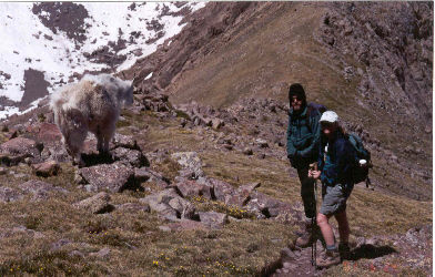
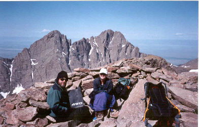
I am certainly not the only one to do this as there is lots of traffic on the north flank and it really is not that much more effort to pick ones route up that way instead. We continued, actually on trail segments, coming close to the ridgeline and then climbing up a short cliff band (just a bit of cairned hand and foot). From there, we walked the summit ridge to anther hand and foot pitch, which is the summit proper. Pick your windbreak and pick your view, Marble Mountain, the Wet Mountain valley below, Carson to the west or perhaps the Crestones? Humboldt may be a walk up but it is a walk up worth doing for the view alone. We took the proper cairned route down the ridge of the peak and came upon a mountain goat at the saddle. My wife always says leave the wildlife alone and I obey; this goat came to us as noted in the photos. Sorry goat, the good news is we are all three from Wyoming AND we are not salivating at the thought of shooting you, the bad news is we are not from California so there will be no granola handout. We retraced our route to the Upper Lake and on back to camp. The weather was coming in and after the rain began to threaten in earnest, we broke camp and headed on down the road to the valley below and dinner in Westcliffe. For those interested, the pizza joint in the old building, likely in Silvercliffe proper, does a good feed before you head on back to the Front Range. |
