Mount Rainier
Approach - Base to Camp Schurman - June 15, 2008
 After spending the first two days in Seattle and consequently, at sea level, we had played toursit, eaten fresh sea food and taken in a ball game. We had little other reason to stay in the Seattle area other than to shed more of the valuable red blood cells we had brought from Cheyenne, elevation 6000 feet. We set off for Mount Rainier. After spending the first two days in Seattle and consequently, at sea level, we had played toursit, eaten fresh sea food and taken in a ball game. We had little other reason to stay in the Seattle area other than to shed more of the valuable red blood cells we had brought from Cheyenne, elevation 6000 feet. We set off for Mount Rainier.
Rainier would be a different sort of climb than we are accustomed to in Colorado. We generally leave home and park at a trail head at elevation 9,000 or 10,000 feet. We climb to the summit of a high 13'er or a 14'er and gain 3500 to 5000 feet. This climb would be different as we would see the full 14,411 height of the peak from sea level, drive to a snow bound trail head at elevation 5000 feet and then, of course, climb to the elevation we 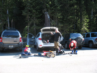 were accustomed to achieving. Oh yea, did I mention that glaciers are not a factor in Colorado whereas in this case we would be roping up at the 7500 foot mark and have to travel as a rope team all the way to the summit? were accustomed to achieving. Oh yea, did I mention that glaciers are not a factor in Colorado whereas in this case we would be roping up at the 7500 foot mark and have to travel as a rope team all the way to the summit?
We left Seattle proper and headed toward Enumclaw. We would not start our climb on this day but we would acquire the food for the days on the mountain and check in at the ranger station to get our permit and note any observations they might have as to the trail conditions. We stopped at a large Safeway off the Maple Valley highway, got the food for the climb and a quick lunch at a nearby McDonalds. Then it was onward to Mt. Rainier Park, where we checked in at the ranger station to pick up our climbing permit. The 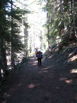 ranger told us that the trail from the parking area was snow covered more or less from the start, that the trail to the summit was not yet boot packed, that a crevasse was starting to open up on the Interglacier, and that the forecast called for good weather . . . for a couple days. ranger told us that the trail from the parking area was snow covered more or less from the start, that the trail to the summit was not yet boot packed, that a crevasse was starting to open up on the Interglacier, and that the forecast called for good weather . . . for a couple days.
 We could not camp at the trail head as the White River Campground was still snowed in so it was back to a National Forest campground just a few miles outside of the park. We found a good camp spot and broke out all the gear. The group gear got put in one pile, we gathered what personal gear were going to take and each of us selected that piece of "pussy gear" that might make the time at Camp Shurman a bit more comfortable. As usual the filled packs were too damn heavy and unfortunately, we were not going to lug the 45 to 50 pound packs up some well graded trail . . . but instead we would have to travel across snow drifted trail and then up 2500 feet of glacier to get to the high camp. If you ask me, 5000 feet of vertical on the approach does not seem like a good way to start any climb. We could not camp at the trail head as the White River Campground was still snowed in so it was back to a National Forest campground just a few miles outside of the park. We found a good camp spot and broke out all the gear. The group gear got put in one pile, we gathered what personal gear were going to take and each of us selected that piece of "pussy gear" that might make the time at Camp Shurman a bit more comfortable. As usual the filled packs were too damn heavy and unfortunately, we were not going to lug the 45 to 50 pound packs up some well graded trail . . . but instead we would have to travel across snow drifted trail and then up 2500 feet of glacier to get to the high camp. If you ask me, 5000 feet of vertical on the approach does not seem like a good way to start any climb.
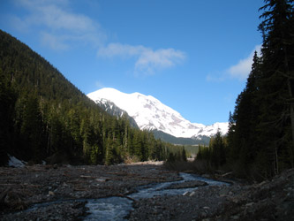
 The next morning we piled into the Santa Fe and headed back to the park to get the climb underway. We arrived at the White River trail head at 8:30, broke out the gear and thought about the size of this 14'er as compared to ones where you start out at a higher elevation. The drive in had one scenic pull out that really put the peak in perspective. Simply put, it was going to be a long walk in to this climb and then it was going to be a long way up to the top. Of course, this was no real surprise, we all knew the tale of the tape before we left Denver. The next morning we piled into the Santa Fe and headed back to the park to get the climb underway. We arrived at the White River trail head at 8:30, broke out the gear and thought about the size of this 14'er as compared to ones where you start out at a higher elevation. The drive in had one scenic pull out that really put the peak in perspective. Simply put, it was going to be a long walk in to this climb and then it was going to be a long way up to the top. Of course, this was no real surprise, we all knew the tale of the tape before we left Denver.
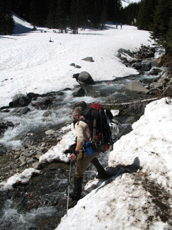 A climbing group left just ahead of us and a couple of skiers soon followed. We grabbed the hiking poles and hefted the packs, it was about 9 in the morning. The start of the trail head is not actually at the parking lot where climbers park but up at the tip of the campground proper. We walked the campground road for a short bit and then cut right and onto the snow. The trail was obvious by the trail cut but it was also obvious that we were here early in the season and we would have a snowy approach. We planned to take a slow pace, stop for some water and a gu every hour or so and trudge our way to Camp Shurman. The first portion of the trail has easy to follow but when we hit the creek, the effect of winter snows, spring runoff and some obvious flooding had necessitated the park service flagging the trail with ribbons of yellow caution tape to mark the path through dead fall and washed out trail sections. A climbing group left just ahead of us and a couple of skiers soon followed. We grabbed the hiking poles and hefted the packs, it was about 9 in the morning. The start of the trail head is not actually at the parking lot where climbers park but up at the tip of the campground proper. We walked the campground road for a short bit and then cut right and onto the snow. The trail was obvious by the trail cut but it was also obvious that we were here early in the season and we would have a snowy approach. We planned to take a slow pace, stop for some water and a gu every hour or so and trudge our way to Camp Shurman. The first portion of the trail has easy to follow but when we hit the creek, the effect of winter snows, spring runoff and some obvious flooding had necessitated the park service flagging the trail with ribbons of yellow caution tape to mark the path through dead fall and washed out trail sections.
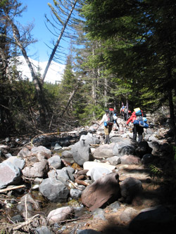
 Route finding was not really hard but seemed a pain as we wandered, just here and there, and then dropped into the gravel stream course for a bit of climbing over knocked down tree trunks before hitting the intact trail again. The summer trail is, of course, obvious and a back country highway but we were just a few weeks early and the trail crew just had not gotten to this point of their punch list yet. After going for perhaps 45 minutes we cleared the dead fall and washouts and were onto the trail which now was more open to the sky and the snow cover was now just patchy. Route finding was not really hard but seemed a pain as we wandered, just here and there, and then dropped into the gravel stream course for a bit of climbing over knocked down tree trunks before hitting the intact trail again. The summer trail is, of course, obvious and a back country highway but we were just a few weeks early and the trail crew just had not gotten to this point of their punch list yet. After going for perhaps 45 minutes we cleared the dead fall and washouts and were onto the trail which now was more open to the sky and the snow cover was now just patchy.
 Our next obstacle came at about 1:15 into the approach where the trail turned left and crossed through a serious swath of avalanche debris. Broken trees and the smell of freshly melted out evergreen splinters filled the air. The trail cut up and over and then back down through the swath of broken forest over a distance of one to two hundred feet before we were back on solid ground once again. The path next cut through a wonderful stand of old growth forest, called the Sherwood Forest. Moss covered trees, thick verdant ground cover and again the smell of evergreens filled the air. But, it was dark and again a snowy path but the route from here to tree line was never in question. Coming from Cheyenne, it is Our next obstacle came at about 1:15 into the approach where the trail turned left and crossed through a serious swath of avalanche debris. Broken trees and the smell of freshly melted out evergreen splinters filled the air. The trail cut up and over and then back down through the swath of broken forest over a distance of one to two hundred feet before we were back on solid ground once again. The path next cut through a wonderful stand of old growth forest, called the Sherwood Forest. Moss covered trees, thick verdant ground cover and again the smell of evergreens filled the air. But, it was dark and again a snowy path but the route from here to tree line was never in question. Coming from Cheyenne, it is 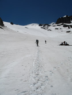 nice to walk amongst the old growth forest as we euphemistically call our Wyoming environment a "high prairie." nice to walk amongst the old growth forest as we euphemistically call our Wyoming environment a "high prairie."
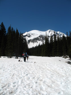
The trail parallels the White River coming down from the toe of the Emmons Glacier until the valley containing the glacier splits off to the left and the trail continues up a lesser drainage. The climbing to this point has been steady, but never steep, and after another mile or so we break out of the forest into the area called Glacier Meadows. We made a stream crossing and it was clear that we were now going to be on snow for the duration of the climb. We had a few hours under our belt, perhaps three and change but we still had about 3000 feet to climb and my pack, if not that of the others, was as heavy as it was at the start and there seemed to be no relief in sight for shoulders starting to tire.
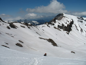 Once across the creek, the route curves off to the right and starts to climb in earnest. There were many skiers climbing as well as they seemed to be headed for a run down the Interglacier, if the contours on the map were telling a predictable skier's tale. We took an ascending course and trudged on through what was now softening snow, exposed to the full effect of the sun in the clear sky overhead. We'd heard tales of horrid foggy days and over cast but we were not seeing such conditions on this approach. No. . . we were in the sun and starting to bake on the white expanse of snow that promised only to get hotter as the afternoon wore on. We stopped however, at a rock outcropping at the well camouflaged toe of the Interglacier, ate a good lunch, drank up and Once across the creek, the route curves off to the right and starts to climb in earnest. There were many skiers climbing as well as they seemed to be headed for a run down the Interglacier, if the contours on the map were telling a predictable skier's tale. We took an ascending course and trudged on through what was now softening snow, exposed to the full effect of the sun in the clear sky overhead. We'd heard tales of horrid foggy days and over cast but we were not seeing such conditions on this approach. No. . . we were in the sun and starting to bake on the white expanse of snow that promised only to get hotter as the afternoon wore on. We stopped however, at a rock outcropping at the well camouflaged toe of the Interglacier, ate a good lunch, drank up and 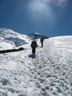 roped up for the climb up the first of the two glaciers we would have to cross to get to Camp Shurman. roped up for the climb up the first of the two glaciers we would have to cross to get to Camp Shurman.
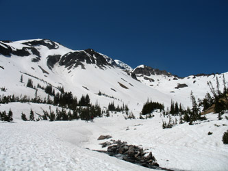
Where the Interglacier really started I am unsure as all one can really see is the expanse of a large snow field steadily rising up before you. At some point in the summer the valley snow obviously melts out and exposes the toe but we were too early. Instead, we just figured to rope up before the slope really stated it climb to be on the safe side. The skiers were, to a man or woman, not roping up but of course my engineer's mind tells me that they were spreading their weight out over a larger surface area, likely substantially decreasing their odds of a crevasse fall. Of course, a weak snow bridge on a crevasse running in their direction of travel might make for a challenging afternoon. Regardless, I was a visitor to their turf, they knew the terrain far better than I.
 But I did not really care too much about the progress of the skiers as I was more interested in just how many rolls were on this glacier and how each one would translate into a false summit. A fellow we had met in Peru had sent me an email just before we left, warning of the false summit effect and I knew it was coming. We trudged upward, me bringing up the tail end of the rope. We were a good rope team and the pace was just dead on for a gentle climb with but a stop here and there for a sip of water. The rest step was the name of the game and the gears were all connecting just fine as we steadily gained the vertical feet needed to get to Camp Shurman. The first roll came and went, the second came and went and the third was topped by a fin of rock, a generally good sign that the glacier is either petering out or there will at least be a change of climbing scenery. But I did not really care too much about the progress of the skiers as I was more interested in just how many rolls were on this glacier and how each one would translate into a false summit. A fellow we had met in Peru had sent me an email just before we left, warning of the false summit effect and I knew it was coming. We trudged upward, me bringing up the tail end of the rope. We were a good rope team and the pace was just dead on for a gentle climb with but a stop here and there for a sip of water. The rest step was the name of the game and the gears were all connecting just fine as we steadily gained the vertical feet needed to get to Camp Shurman. The first roll came and went, the second came and went and the third was topped by a fin of rock, a generally good sign that the glacier is either petering out or there will at least be a change of climbing scenery.
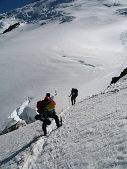
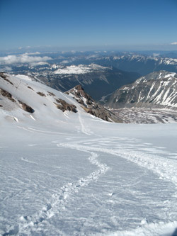 The topo map and our elevation told a predictable story as we were nearing the top of the Interglacier and we would soon drop down onto the much larger Emmons Glacier for the final climb of perhaps 500 vertical feet to Camp Shurman, not in a straight line of course. The rocky ridge was a rest point for our group as we noted that we would drop onto the Emmons, losing perhaps 200 feet of vertical progress into the process. We would then follow a herd path of tracks up the glacier and then swing wide of a gaping crevasse before cutting back to the left to what we knew would be Camp Shurman around the side of the next rock ridge. We lost the elevation, all too easily, and then took on the hot and sunny trudge on up the wide snowy terrain to to Camp Shurman. Yes, there it was as promised on the map, a ranger's hut perched on another rocky fin dividing the bulk of the Emmons from the Winthrop Glacier. The topo map and our elevation told a predictable story as we were nearing the top of the Interglacier and we would soon drop down onto the much larger Emmons Glacier for the final climb of perhaps 500 vertical feet to Camp Shurman, not in a straight line of course. The rocky ridge was a rest point for our group as we noted that we would drop onto the Emmons, losing perhaps 200 feet of vertical progress into the process. We would then follow a herd path of tracks up the glacier and then swing wide of a gaping crevasse before cutting back to the left to what we knew would be Camp Shurman around the side of the next rock ridge. We lost the elevation, all too easily, and then took on the hot and sunny trudge on up the wide snowy terrain to to Camp Shurman. Yes, there it was as promised on the map, a ranger's hut perched on another rocky fin dividing the bulk of the Emmons from the Winthrop Glacier.
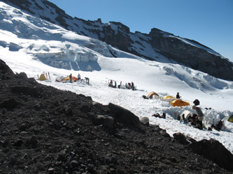 Camp Shurman is kind of Denali-esque, a flat area with shoveled out tent pads, some with wind walls surrounding them. We looked at the open spaces and chose one that was big enough to take our two tents. However, we would still have to do some more shoveling to widen the pad out to get into and out of the tents and to make a spot to set the stove for some serious snow melting. The tents went up, the sleeping bags were set to lofting and we gathered a big garbage bag of snow for melting. Soon enough we had water for the night and a ramen dinner spruced up with salami and fresh broccoli. Camp Shurman is kind of Denali-esque, a flat area with shoveled out tent pads, some with wind walls surrounding them. We looked at the open spaces and chose one that was big enough to take our two tents. However, we would still have to do some more shoveling to widen the pad out to get into and out of the tents and to make a spot to set the stove for some serious snow melting. The tents went up, the sleeping bags were set to lofting and we gathered a big garbage bag of snow for melting. Soon enough we had water for the night and a ramen dinner spruced up with salami and fresh broccoli.
The question now was whether we should climb the next day or lay in for one day of rest, given that we had 5000 feet of vertical on our bodies and that we would need to gain another 5000 to make the summit of the peak. The weather window turned out to be the controlling 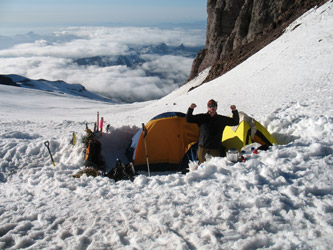 factor as we knew the next day would be good but we were also clued into the following day's forecast being less than favorable. We were early in the season and we had food for two nights, this night and the following evening. We could stay but the second day would be a climb or retreat day, calling for a new approach later in the week if we retreated after a failed summit bid or after being held down by weather. We also did not have a lot of reserves in the event the weather pinned us down but we knew that the forecast was not for a hard storm but really more a case of greater winds on the peak. factor as we knew the next day would be good but we were also clued into the following day's forecast being less than favorable. We were early in the season and we had food for two nights, this night and the following evening. We could stay but the second day would be a climb or retreat day, calling for a new approach later in the week if we retreated after a failed summit bid or after being held down by weather. We also did not have a lot of reserves in the event the weather pinned us down but we knew that the forecast was not for a hard storm but really more a case of greater winds on the peak.
Though we had spent 9 hours getting to Camp Shurman, we decided to set the alarm for 1:00 am and take a shot at an 2:00 am departure for the summit. With that decision made, we melted sufficient water for the next day and took to the tents at around 8:30, knowing that the alarm would go off all too soon.
|
