California Peak
May 1, 2010 - North Ridge
I packed the truck on Friday morning, as I was leaving directly from work to meet Ed at his place between 4 and 5 in the afternoon. It was an early season climb and I packed what I considered a most important item, an item absent from later season travels . . . a chainsaw for the likely aspen across the road. We loaded Ed's gear and were off to the Sangre de Christos, heading for Walsenburg and then up the long approach that, if the last two weeks of warm weather had any effect, might land us somewhat close to the lower Huerfano trail head from which we would attempt California Peak.
 Ed and I last climbed in the Fall when I accompanied him on a climb of the South Bell, a 14'er he needed and he went with me the next day to the summit of Cathedral Peak, a Centennial in the same neighborhood. We pulled off a Spring climb last year when we scored Wetterhorn and Uncompahgre, knocking two more 14'ers from his shopping list in spring snow form. Our plan for this weekend was the same thing, a new 14'er for him and the target was Sneffels, but the weather was having no part of our plan. Snow was called for on the Front Range the Sawatch and in Ouray, the starting point for a Sneffels climb. That meant that we would have to deal with snow not only in getting to a high trail head but also in getting to the jumping off point. Ed and I last climbed in the Fall when I accompanied him on a climb of the South Bell, a 14'er he needed and he went with me the next day to the summit of Cathedral Peak, a Centennial in the same neighborhood. We pulled off a Spring climb last year when we scored Wetterhorn and Uncompahgre, knocking two more 14'ers from his shopping list in spring snow form. Our plan for this weekend was the same thing, a new 14'er for him and the target was Sneffels, but the weather was having no part of our plan. Snow was called for on the Front Range the Sawatch and in Ouray, the starting point for a Sneffels climb. That meant that we would have to deal with snow not only in getting to a high trail head but also in getting to the jumping off point.
 Ouray is a solid 7 hours from Cheyenne in good weather, I really did not think we could pull off a turbo weekend in bad weather . . . so we changed the plan. It seemed like the only mountain range that would get away with a minimal effect of the weekend snow was the Sangres, so we picked a trail head that might be open and a peak that neither of us had been on before. We headed south with a dinner stop in Colorado Springs, gas in Walsenburg, and then off to Gardner, Ouray is a solid 7 hours from Cheyenne in good weather, I really did not think we could pull off a turbo weekend in bad weather . . . so we changed the plan. It seemed like the only mountain range that would get away with a minimal effect of the weekend snow was the Sangres, so we picked a trail head that might be open and a peak that neither of us had been on before. We headed south with a dinner stop in Colorado Springs, gas in Walsenburg, and then off to Gardner, 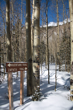 the turnoff point to the last 20+ miles that we hoped would land us at the trail head. We got about 12 miles before the first sign of snow but that was OK because it was just a skiff on the road from a passing squall, no problem, our luck was holding. We got to the Singing River Ranch and we had a white road but still little more than a dusting. the turnoff point to the last 20+ miles that we hoped would land us at the trail head. We got about 12 miles before the first sign of snow but that was OK because it was just a skiff on the road from a passing squall, no problem, our luck was holding. We got to the Singing River Ranch and we had a white road but still little more than a dusting.
The trail head is at mile 21.2 and we forced our way through a drift at about mile 18 on an uphill that took four attempts but landed us smooth sailing on the other side. We found our next drift at mile 19.1 and that one brought our vehicular approach to an end. We were two miles shy of the trail head, meaning an 8+ mile climb just went to 12+ and we were still shy of the Forest Service boundary. We did have a convenient pull off so that was it for the night. I made sure the truck would allow another to pass and we made a quick camp for 6 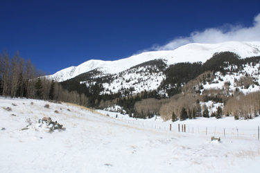 hours, no fire, no disturbance, and the tent was packed and in the truck before we left the next morning. Just one of those fast end of the road, hope we don't get hassled, leave less than no trace camps. hours, no fire, no disturbance, and the tent was packed and in the truck before we left the next morning. Just one of those fast end of the road, hope we don't get hassled, leave less than no trace camps.
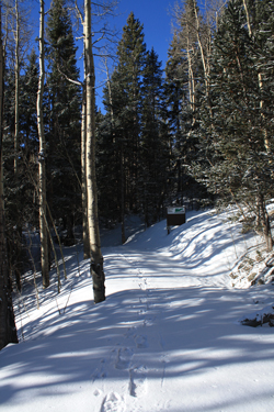
The alarm went off the next morning at 5:30 and our camp was down and packed by six. We took advantage of the warm truck for 45 minutes while we garnered our gear for what became a 7 a.m. start two extra miles from the official starting point. We debated crampons and snowshoes, the snowshoes got a thumbs up and the crampons a down vote. The morning was cold so the shoes were cinched to the pack and off we went up the road, walking atop the drifts and snowpack. We got to about mile 19.4 and the trees stopped as we entered a 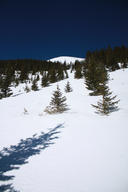 long open space. The wind was howling, the snow as blowing and though we did not admit it until later, we both gave serious thought to bagging the climb just 15 minutes form the truck. long open space. The wind was howling, the snow as blowing and though we did not admit it until later, we both gave serious thought to bagging the climb just 15 minutes form the truck.
The wind was whipping down the valley at 30 mph and the outside temp was cold, down around 15 I'd guess. My toes were cold and my hands were starting to chill, I almost hoped that Ed would call out a willingness to turn but then again I think we both figured if we could get to the trees, we'd have enough of a break to keep going in some sort of moderately positive frame of mind. We progressed to the trees after a 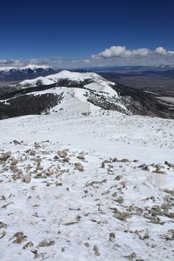 half mile or so where the wind was held back by the forest. We walked atop ever deeper snow with some 4 and 6 foot deep hummocks here and there before arriving at the forest service boundary at about mile 1 of the climb. The snow was quite deep at this point and there was no doubt that the road would not open for few weeks, but we were really just thankful for having gotten as far as we did the night before. half mile or so where the wind was held back by the forest. We walked atop ever deeper snow with some 4 and 6 foot deep hummocks here and there before arriving at the forest service boundary at about mile 1 of the climb. The snow was quite deep at this point and there was no doubt that the road would not open for few weeks, but we were really just thankful for having gotten as far as we did the night before.
Perhaps two hundred yards past the forest boundary, there is a sign board where we stopped to look at the map. We knew that we were looking for the Zapata trail but also knew from the Roach guide that there was a "small sign" marking the trail cut off. Depending upon the size of the sign, we thought this might be our junction and the topography looked perfect for a course leading to Zapata Pass, our access point to the ridge that would lead us to the summit of California Peak. We looked at the map and came to the conclusion that, though the topography was looking great for a course to the saddle, the trailhead must be further long the snow covered road. It was and about 15 minutes later, we found a not so small sign that announced our arrival at the juncture with the Zapata/Huerfano trails.
 We stopped for some water and food before heading up toward the Zapata saddle and what we figured would be a cold and windy ridge walk to the summit. The trail cut was obvious at first, then fell out of sight but the direction we had to go was clear and the topography told us where the trail should be. Sure enough, we came around a bend and there was the trail once again, covered by snow but obvious in the fact that it was cut into the side of the hill, leaving a tell tale trace. We climbed and even got a section of dry path for a few yards here and there before coming out into an open meadow that gave us a view of the saddle we were aiming for. We discussed route selection and instead of making for the pass, We opted instead to cut a southerly course to intercept a fin that would take us to a point on the ridge beyond the first few bumps, give us more time in the lee of the high ground, but our gain would be at the cost of having to climb steeper ground to get there. We stopped for some water and food before heading up toward the Zapata saddle and what we figured would be a cold and windy ridge walk to the summit. The trail cut was obvious at first, then fell out of sight but the direction we had to go was clear and the topography told us where the trail should be. Sure enough, we came around a bend and there was the trail once again, covered by snow but obvious in the fact that it was cut into the side of the hill, leaving a tell tale trace. We climbed and even got a section of dry path for a few yards here and there before coming out into an open meadow that gave us a view of the saddle we were aiming for. We discussed route selection and instead of making for the pass, We opted instead to cut a southerly course to intercept a fin that would take us to a point on the ridge beyond the first few bumps, give us more time in the lee of the high ground, but our gain would be at the cost of having to climb steeper ground to get there.
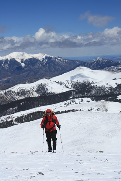 We cut across the flat of this perched basin and attacked the fall line to gain ground at a fast pace. We steered clear of any obvious avi issues but also knew that we'd had a hard freeze and there was little chance of getting into too much trouble at this early hour. We gained rock where possible and after a very hard fought hour and a half to two hours, we gained the ridge and . . . the wind. Fortunately, the sun was high in the sky and the wind had elected to grant us a brief respite for at least a portion of the ridge walk to come. We rested briefly and noted that the rest of the climb would be a matter of climbing to a false summit, dropping a short distance off the back side and then climbing to the next false summit, repeating the action. But it would not be that bad, we only had to do this a few times and we would be on the summit, in good time. We cut across the flat of this perched basin and attacked the fall line to gain ground at a fast pace. We steered clear of any obvious avi issues but also knew that we'd had a hard freeze and there was little chance of getting into too much trouble at this early hour. We gained rock where possible and after a very hard fought hour and a half to two hours, we gained the ridge and . . . the wind. Fortunately, the sun was high in the sky and the wind had elected to grant us a brief respite for at least a portion of the ridge walk to come. We rested briefly and noted that the rest of the climb would be a matter of climbing to a false summit, dropping a short distance off the back side and then climbing to the next false summit, repeating the action. But it would not be that bad, we only had to do this a few times and we would be on the summit, in good time.
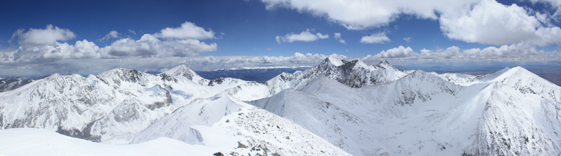
 We climbed the first two false summits and with a sigh made it to our third ridge hump, the summit of the peak. But something was very wrong, we could see Blanca and Ellingwood but there was a tall peak between us and those known summits. Now I knew that there were no other high 13'ers between us and Ellingwood, high ridge points, but nothing higher than the summit of California. Ed checks his altimeter and it reads 13,450 . . . something was really out of whack here . . . We climbed the first two false summits and with a sigh made it to our third ridge hump, the summit of the peak. But something was very wrong, we could see Blanca and Ellingwood but there was a tall peak between us and those known summits. Now I knew that there were no other high 13'ers between us and Ellingwood, high ridge points, but nothing higher than the summit of California. Ed checks his altimeter and it reads 13,450 . . . something was really out of whack here . . .
What was out of whack was our spatial perception of where we were and the fact that we had achieved the high point we saw from below but not the true summit that was what looked like another mile along the ridge. We had a pow-wow and admitted that it was now 12:30 in the afternoon and that we were still a good way from the summit. We agreed to go one more false summit and then decide again as to continue or retreat.
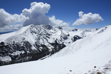
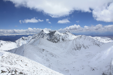 We scored our next false summit, or actually, I'd like to call it a maliciously deceptive summit and saw that we were closer but still had a good couple of hundred feet of vertical and a half mile to score the true summit, or more accurately, the fore-summit bump. We were tired but making good time . . . however the storm that we knew was bringing snow to the Sawatch, was sending squalls south to play with the Crestones to the north of our location. We had light until 8 p.m. and a ridge that led to an obvious pass and drop to the road below. Route finding would not be an issue if we continued to the summit. We dropped into the trough between the false summit and the fore-summit bulge, climbed to the fore-summit and then easily walked on over to the summit proper. The wind was blowing nicely and the tendrils of a squall were starting to advance upon us from the San Luis Valley to our west. We scored our next false summit, or actually, I'd like to call it a maliciously deceptive summit and saw that we were closer but still had a good couple of hundred feet of vertical and a half mile to score the true summit, or more accurately, the fore-summit bump. We were tired but making good time . . . however the storm that we knew was bringing snow to the Sawatch, was sending squalls south to play with the Crestones to the north of our location. We had light until 8 p.m. and a ridge that led to an obvious pass and drop to the road below. Route finding would not be an issue if we continued to the summit. We dropped into the trough between the false summit and the fore-summit bulge, climbed to the fore-summit and then easily walked on over to the summit proper. The wind was blowing nicely and the tendrils of a squall were starting to advance upon us from the San Luis Valley to our west.
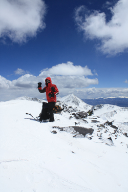 We took the required summit shots and spent all of 5 minutes on top before heading back toward the truck. The wind picked up and we got a shot of snow here and there as we reversed out route back down the long ridge line. Though I hate false summits, this ridge had provided short drops off the uphill sides of each false summit that proved not enough to cause me to lament that "these up-hills are going to kill me." The distance down the ridge is not short by any means and I was glad that we elected to take our own course to intercept the ridge at about the 1/2 point instead of climbing to Zapata pass proper and then doing the whole of the ridge. it would have been a miserable climb. We took the required summit shots and spent all of 5 minutes on top before heading back toward the truck. The wind picked up and we got a shot of snow here and there as we reversed out route back down the long ridge line. Though I hate false summits, this ridge had provided short drops off the uphill sides of each false summit that proved not enough to cause me to lament that "these up-hills are going to kill me." The distance down the ridge is not short by any means and I was glad that we elected to take our own course to intercept the ridge at about the 1/2 point instead of climbing to Zapata pass proper and then doing the whole of the ridge. it would have been a miserable climb.
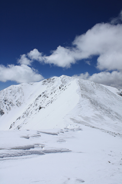
We descended to Zapata Pass and for the last half mile or so, I tested the snow fields to get a feel for the effect of the sun on the snow. I knew that the drop off the east side of Zapata Pass would cause us to make a step descent to the perched flat below and I needed to have an idea of whether we were now going to have avi worries above and beyond just being tired. The snow was taking a heel but not allowing any post holing so we skirted the cornice that guarded the lowest portion of the saddle and cut a wide sweeping course through sparse trees to ensure 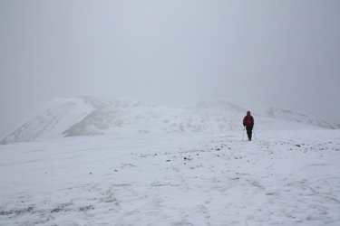 that we would land right at the meadow and not have a foot of ascent to get to that checkpoint. From the meadow we regained our ascent trail and dropped into the trees to descend to the road below. this was where we found that the warm temps had been hiding all day as the snow had truly gone to hell and we were soon post holing knee deep with every other step. that we would land right at the meadow and not have a foot of ascent to get to that checkpoint. From the meadow we regained our ascent trail and dropped into the trees to descend to the road below. this was where we found that the warm temps had been hiding all day as the snow had truly gone to hell and we were soon post holing knee deep with every other step.
We opted to skip the trail when we came to a draw that has a melted bank and from there we cut to the valley floor choosing the most direct course to connect the bare spots here and there, or the darker shadowed sections where the odds of finding harder snow were better. Soon enough we cut the road and were outbound. The road was a bit better snow-wise but after perhaps a quarter mile, we donned the snowshoes and from that point on made better time.  We hit the open area that had been so cold that morning and were confronted with a road where before there was just a trace of the route across a white snow covered field. Now we had a road, so the snowshoes came off and to our surprise we walked on dirt almost all the way of the truck. But for a hundred yards of now fully saturated drifts, the road had melted out for fully an additional half mile over what we experienced on the way in, just 8 hours before. We hit the open area that had been so cold that morning and were confronted with a road where before there was just a trace of the route across a white snow covered field. Now we had a road, so the snowshoes came off and to our surprise we walked on dirt almost all the way of the truck. But for a hundred yards of now fully saturated drifts, the road had melted out for fully an additional half mile over what we experienced on the way in, just 8 hours before.
We got to the truck and drove back down past the Singing River Ranch to the state game land camping area on the far side of the ranch property. We picked a camp spot back in the trees and set up camp for the night. Our original plan was to take a shot at Huerfano the next day but after this climb, we did not have much enthusiasm for the plan. Reaching Huerfano would 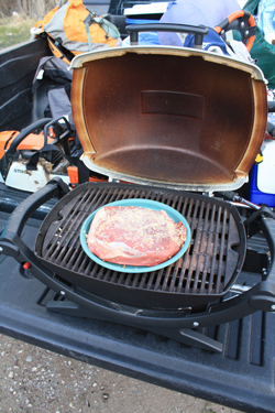 have been a matter of busting our way up the drifted Huerfano trail switchbacks and then executing a cross country approach or, alternatively,having to ascend the Mount Lindsey route and skirting the Iron Nipple to access Huerfano. Given the forecast of deteriorating weather, we opted to eat a good dinner, sip some Baileys and then call it a day without setting the alarm for the next morning. have been a matter of busting our way up the drifted Huerfano trail switchbacks and then executing a cross country approach or, alternatively,having to ascend the Mount Lindsey route and skirting the Iron Nipple to access Huerfano. Given the forecast of deteriorating weather, we opted to eat a good dinner, sip some Baileys and then call it a day without setting the alarm for the next morning.
Sure enough 7:30 a.m. came around and we broke camp by 8:00 and wandered north, one summit in hand and a appetite still satisfied from the pound and half of Pacanya (Brazilian style steak) and potatoes cooked on the grill perched on the tailgate the night before.
Huerfano came later with a summer climb . . .
|
